Showing 3732 items matching "dd-08"
-
 Bendigo Historical Society Inc.
Map - RESURVEY, PARISH OF SANDHURST, 1/08/1891
... 1/08/1891 ...Map: Resurvey , Parish of Sandhurst sheet 3. Parish plan ( number 203 in Map Cupboard 1)map, bendigo, parish plan, parish of sandhurst resurvey -
 Bendigo Historical Society Inc.
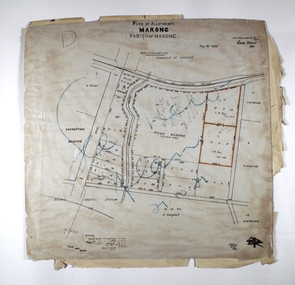
Map - MARONG ALLOTMENTS, 25/08/1906
... 25/08/1906 ...Map: Plan of Allotments at Marong, Parish of Marong, County of Bendigo. Hand draughted mapmap, bendigo, parish plan, marong, parish of marong -
Bendigo Historical Society Inc.
Map - FOSTERVILLE MAP, 19/08/1897
... 19/08/1897 ...Map: Township of Fosterville, Parish of Ellesmere, County of Bendigo. Parish plan (number 277 in map cupboard 1)map, bendigo, township, fosterville, ellesmere -
 Bendigo Historical Society Inc.
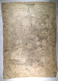
Map - NERRING, 25/08/1903 ?
... 25/08/1903 ? ...Map: Parish of Nerring, County of Bendigo. Parish plan Canvas backedmap, bendigo, rural, nerring, county of bendigo -
Bendigo Historical Society Inc.
Map - BAMAWM ESTATE, 12/.08/1912
... 12/.08/1912 ...Map: Bamawm Estate, Acquired under Closer settlements Acts 1904, County of Bendigo. Parish Plan Canvas backed. ( number 130 in Map Cupboard 1)map, bendigo, rural, bamawm estate, closer settlement acts 1904, county of bendigo -
Bendigo Historical Society Inc.
Map - TARNAGULLA, 8/08/1912
... 8/08/1912 ...Map: Tarnagulla sheet 2. Parish plan ( number 241 in Map Cupboard 1)map, talbot, parish plan, tarnagulla -
Bendigo Historical Society Inc.
Map - TARNAGULLA SHEET 1, Examined 25/08/1926
... Examined 25/08/1926 ...Map: Tarnagulla Sheet 1, Counties of Gladstone and Bendigo. Parish plan (number 304 in map cupboard 1)map, gladstone, parish plan, tarnagulla -
Bendigo Historical Society Inc.
Map - ELMORE, 7/08/1911
... 7/08/1911 ...Map: Township of Elmore, Parish of Elmore, County of Bendigo ( number 159 in Map Cupboard 1)map, bendigo, township, elmore, county of bendigo -
Bendigo Historical Society Inc.
Map - GOORNONG, 21/08/1888
... 21/08/1888 ...Map: Parish of Goornong, County of Bendigo. Parish plan (number 345 in map cupboard 1)map, bendigo, parish plan, goornong -
Bendigo Historical Society Inc.
Map - CALAVIL, 28/08/1874
... 28/08/1874 ...Map: Country Lands, Parish of Calavil, County of Bendigo. Parish plan (number 334 in map cupboard 1)map, bendigo, country lands, country lands, parish of calavil -
Bendigo Historical Society Inc.
Map - AVAILABLE ALLOTMENTS, 10/08/1908
... 10/08/1908 ...map: Available Allotments, Parishes of Whirrakee, Bagshot and Egerton, County of Bendigo. Parish plan (coloured) (number 330 in map cupboard 1)map, bendigo, allotments, available allotments, whirrakee, bagshot, egerton -
Bendigo Historical Society Inc.
Map - MARONG, 16/08/1881
... 16/08/1881 ...Map: Parish of Marong, County of Bendigo. Parish plan (number 328 in map cupboard 1)map, bendigo, parish plan, marong -
 Bendigo Historical Society Inc.
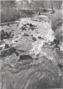
Photograph - BENDIGO ADVERTISER COLLECTION: BULLOCK CREEK LOCKWOOD SOUTH, 10/08/1993
... 10/08/1993 ...Lockwood South Bullock Creek in flood. On rear of image Lockwood Sth 10/8/93. PART OF THE SMALL TOWNS WITH BIG HEARTS SERIESregion, small towns, lockwood south -
 Bendigo Historical Society Inc.
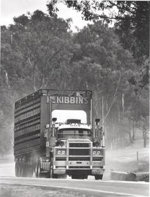
Photograph - BENDIGO ADVERTISER COLLECTION: MCKIBBINS CATTLE TRUCK LOCKWOOD SOUTH, 10/08/1993
... 10/08/1993 ...McKibbins cattle truck Lockwood South. Mack truck. Written on back of image Lockwood South 10/8/93.Bill Hawkinsregion, small towns, lockwood south -
 Bendigo Historical Society Inc.
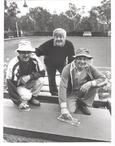
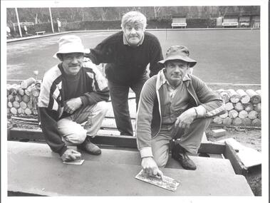
Photograph - BENDIGO ADVERTISER COLLECTION: VIC JOHNSON, GEORGE MANALLACK, ALF MANALLACK LOCKWOOD SOUTH, 10/08/1993
... 10/08/1993 ...Vic Johnson, George Manallack and Alf Manallack at Lockwood South Bowling Club. Written on rear of image Lockwood Sth 10/8/93Bill Hawkinsregion, small towns, lockwood south -
 Bendigo Historical Society Inc.
Photograph - BENDIGO ADVERTISER COLLECTION: ALF MANALLACK, VIC JOHNSON, GEORGE MANALLACK LOCKWOOD SOUTH, 10/08/1993
... 10/08/1993 ...Alf Manallack, Vic Johnson and George Manallack at Lockwood South Bowling Club. Written on rear of image Lockwood Sth 10/8/93Bill Hawkinsregion, small towns, lockwood south -
 Bendigo Historical Society Inc.
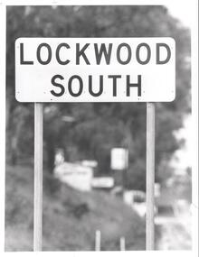
Photograph - BENDIGO ADVERTISER COLLECTION: ROAD SIGN OF LOCKWOOD SOUTH, 10/08/1993
... 10/08/1993 ...Road sign of Lockwood South.Bill Hawkinsregion, small towns, lockwood south -
 Bendigo Historical Society Inc.
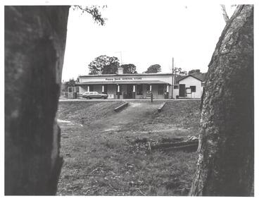
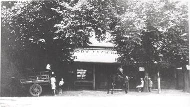
Photograph - BENDIGO ADVERTISER COLLECTION: HAPPY JACK GENERAL STORE LOCKWOOD SOUTH, 10/08/1993
... 10/08/1993 ...Happy Jack general store at Lockwood South, originally a pub. Photo is part of "Small Towns With Big Hearts" article. On rear of photo is written Lockwood Sth 10/3/93.Bill Hawkinsregion, small towns, lockwood south -
 Bendigo Historical Society Inc.
Photograph - BENDIGO ADVERTISER COLLECTION: CAR ON ROAD AT LOCKWOOD SOUTH, 10/08/1991
... 10/08/1991 ...Car travelling along a road at Lockwood South. About to cross a bridge. On rear of image is written Lockwood Sth 10/8/91. Photo appeared in Small Towns With Big Hearts article.Bill Hawkinsregion, small towns, lockwood south -
 Bendigo Historical Society Inc.
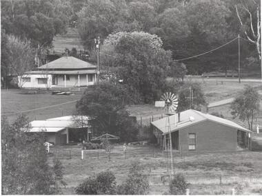
Photograph - BENDIGO ADVERTISER COLLECTION: TWO HOUSES AT LOCKWOOD SOUTH, 10/08/1993
... 10/08/1993 ...Two houses and shedding at Lockwood South. A windmill in foreground. On rear of image is written Lockwood Sth 10/8/93Bill Hawkinsregion, small towns, lockwood south -
 Bendigo Historical Society Inc.
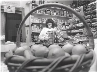
Photograph - BENDIGO ADVERTISER COLLECTION: DENISE RYAN IN THE HAPPY JACK STORE LOCKWOOD SOUTH, 10/08/1993
... 10/08/1993 ...Denise Ryan in the Happy Jack store. Photograph appeared in the article Small Towns With Big Hearts. Written on rear of image Lockwood Sth 10/8/93.Bill Hawkinsregion, small towns, lockwood south -
 Bendigo Historical Society Inc.
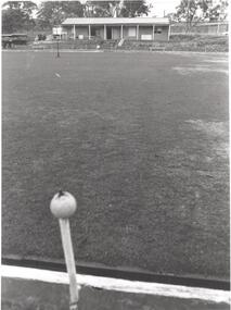
Photograph - BENDIGO ADVERTISER COLLECTION: BOWLING CLUB AT LOCKWOOD SOUTH, 10/08/1993
... 10/08/1993 ...Looking across the greens towards the Lockwood South Bowling Club. On the rear of image is written Lockwood Sth 10/8/93.Bill Hawkinsregion, small towns, lockwood south -
 Bendigo Historical Society Inc.
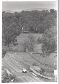
Photograph - BENDIGO ADVERTISER COLLECTION: VIEW OF HOUSES AND TREES AT LOCKWOOD SOUTH, 10/08/1993
... 10/08/1993 ...View of houses and trees at Lockwood South. Photograph has been taken from a high point. On rear of image is written Lockwood Sth 10/8/93.Bill Hawkinsregion, small towns, lockwood south -
 Bendigo Historical Society Inc.
Photograph - BENDIGO ADVERTISER COLLECTION: HAPPY JACK HOTEL IN EARLY 1900S AT LOCKWOOD SOUTH, 10/08/93
... 10/08/93 ...Happy Jack Hotel at Lockwood South. Photograph taken in early 1900s. In front of hotel are six people including one on a horse. The hotel later became the Happy Jack General Store. This information is from the article Small Towns With Big Hearts. On rear of image is written Lockwood Sth 10/8/93.Bill Hawkinsregion, small towns, lockwood south -
 Bendigo Historical Society Inc.
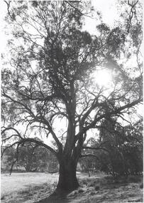
Photograph - BENDIGO ADVERTISER COLLECTION: LARGE GUM TREE AT LOCKWOOD SOUTH, 10/08/1993
... 10/08/1993 ...Large gum tree at Lockwood South. On rear of image is written Lockwood Sth 10/8/93.Bill Hawkinsregion, small towns, lockwood south -
 Bendigo Historical Society Inc.
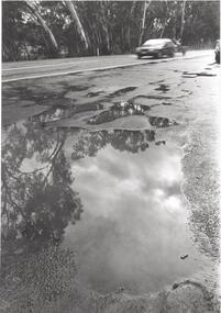
Photograph - BENDIGO ADVERTISER COLLECTION: WATER LAYING ON A ROAD AT LOCKWOOD SOUTH, 10/08/1993
... 10/08/1993 ...Water laying on a road at Lockwood South. The water is reflecting trees and sky. Written on rear of image is Lockwood Sth 10/8/93Bill Hawkinsregion, small towns, lockwood south -
The Beechworth Burke Museum
Audio - Oral History, Jennifer Williams, Mr Tom Carey, 3/08/2000
... 3/08/2000 ...Mr Tom Carey was born in 1940 in Beechworth to family from Beechworth and Woolshed. His family had strong associations with Australia's Gold Rush, with grandparents having followed the rush from town to town, and parents in Beechworth. Tom has strong associations with Beechworth and its surrounds, with his family having some connection to the Kelly Gang. Tom worked in many industries in Beechworth, from the Bridge Road, Price’s Store, tannery, post office, the Kiewa Murray Water Authority, and the Beechworth Council. This oral history recording was part of a project conducted by Jennifer Williams in the year 2000 to capture the everyday life and struggles in Beechworth during the twentieth century. This project involved recording seventy oral histories on cassette tapes of local Beechworth residents which were then published in a book titled: Listen to what they say: voices of twentieth century Beechworth. These cassette tapes were digitised in July 2021 with funds made available by the Friends of the Burke. Mr Tom Carey account of his life in Beechworth and the local area during the 20th century is historically and socially significant to the cultural heritage of the region. He details important historical events and hardships in the region's history that had a lasting local, regional and national impact, including Australia during war time, economic struggles, and women's and men’s societal roles in a rural area. This oral history account is socially and historically significant as it is a part of a broader collection of interviews conducted by Jennifer Williams which were published in the book 'Listen to what they say: voices of twentieth-century Beechworth.' While the township of Beechworth is known for its history as a gold rush town, these accounts provide a unique insight into the day-to-day life of the town's residents during the 20th century, many of which will have now been lost if they had not been preserved. This is a digital copy of a recording that was originally captured on a cassette tape. The cassette tape is black with a horizontal white strip and is currently stored in a clear flat plastic rectangular container. It holds up 40 minutes of recordings on each sideMr Tom Carey/ beechworth, oral history, burke museum, tannery, beechworth council, kelly gang, bridge road, price’s store, post office, the kiewa murray water authority, woolshed, gold rush, carey, tom carey, listen to what they say -
 The Beechworth Burke Museum
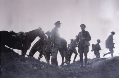
Photograph, 31/08/1918
... 31/08/1918 ...Taken on the 31st of August ,1918, this photograph depicts Gunner Wilson, Lieutenant Driscoll, and Lieutenant Clark (facing camera) of the 12th Battery of Australian Field Artillery, choosing a site for new battery positions, as members of the 52nd Australian Battalion move past to a new sector north of the Somme, before Mont St Quentin.The Battle of Mont St Quentin commenced on the 31st of August 1918 and ended on the 3rd of September 1918. The battle saw Australian troops storm, seize and hold the key height of Mont St Quentin (overlooking Peronne), a pivotal German defensive position on the line of the Somme.Black and white rectangular reproduced photograph on matte photographic paperReverse: 5144/military album, beechworth, burke museum, ww2, world war two, france, somme, 12th battery of australian field artillery, 52nd australian battalion, military, mont st quentin -
 Ballan Shire Historical Society
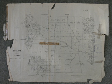
Map - Map. Ballark, Department of Lands and Survey, Ballark. County of Grant, 31/08/1915
... 31/08/1915 ...A map of the Ballark area within the County of Grant showing roads, waterways, property boundaries and property owners in 1915.Significant to people researching land usage and ownership. Also those researching families in the area at that time.A map of Ballark in the County of Grant. Black printing on buff coloured paper. Extra notations by hand and various coloured highlighting of certain features. Details roads, rivers, property boundaries and names of property owners and districts. The map is easily readable although there is some physical damage to the borders and some sellotape residue. Shows a scale in Chains and the number L.6030Various numbers and directional arrows added to map.bungal, borhoneyghurk, bungeeltap, ballark, beremboke, moreep, meredith, morrisons, moorarbool river -
 Ballan Shire Historical Society
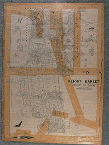
Map - Map. Kerrit Bareet, Department of Lands and Survey, Kerrit Bareet. County of Grant, 08/1944
... 08/1944 ...A map of the Kerrit Bareet area within the County of Grant showing properties and names of owners in 1944.Significant to people researching land usage and ownership. Also those researching families in the area at that time.A map of Kerrit Bareet in the County of Grant. Black printing on buff coloured paper. Details roads, rivers, railways, property boundaries and names of property owners and towns and villages. The map is easily readable although there is some physical damage and that and the borders have been reinforced with sellotape. Shows a Scale in Chains and Price 2/.gordon, bungal, kerrit bareet, lal lal, moorarbool river, warrenheip, bungaree, wallace, moorarbool west