Showing 1372 items matching "east side"
-
 Buninyong & District Historical Society
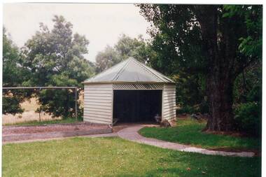
Photograph - Colour photograph, Six sided shelter shed of the former Yendon Primary School 1994
Yendon Primary School operated as a State School from 1877 and ceased operating in 1993. The School initially operated as the Buninyong East Common School from 1864.The children of railway workers from the Ballarat- Geelong railway would have formed much of the opening enrolment of the school.Colour photograph of a six sided shelter shed in the grounds of the former Yendon Primary School 1994Shelter shed Yendon Primary School 1994 6 sidededucation, yendon, state schools -
 Eltham District Historical Society Inc
Photograph - Digital Photograph, Marguerite Marshall, Stuchbery Farm dairy, 14 March 2008
Stuchbery Farm was situated on the Plenty River bounded by Smugglers Gully to the north and La trobe Road, Yarrambat, to the east. Alan and Ada Stutchbery moved to the valley in 1890, first living in a tent where four children were born. Alfred built a home and outbuildings around 1896. They planted an orchard, then a market garden and developed a dairy. Published: Nillumbik Now and Then / Marguerite Marshall 2008; photographs Alan King with Marguerite Marshall.; p179 The dramatic steep-sided Plenty Gorge lies along the divide of two geological areas, and separates the Nillumbik Shire and the City of Whittlesea. On the Nillumbik side are undulating hills and sedimentary rock, and in Whittlesea, lies a basalt plain formed by volcanic action up to two million years ago. This provides the Plenty Gorge Park with diverse vegetation and habitats, making it one of Greater Melbourne’s most important refuges for threatened and significant species. The park, established in 1986, consists of around 1350 hectares, and extends 11 kilometres along the Plenty River, from Greensborough to Mernda. It provides a wildlife corridor for around 500 native plant and 280 animal species. The area’s plentiful food and water attracted the Wurundjeri Aboriginal people and then European settlers. By 1837 squatters had claimed large runs of land for their sheep and cattle. The Plenty Valley was among the first in the Port Phillip District to be settled - mainly in the less heavily timbered west - and was proclaimed a settled district in 1841. But by the late 1880s, the settlers’ extensive land clearing for animal grazing, then agriculture, depleted the Wurundjeri’s traditional food sources, which helped to drive them away. Many Wurundjeri artefacts remain (now government protected), and so far 57 sites have been identified in the park, including scarred trees, burial areas and stone artefacts. Pioneer life could be very hard because of isolation, flooding, bushfires and bushrangers. Following the Black Thursday bushfires of 1851, basalt was quarried to build more fire-resistant homes. Gold discoveries in the early 1850s swelled the population, particularly around Smugglers Gully; but food production made more of an impact. In the late 1850s wheat production supplanted grazing. In the 1860s the government made small holdings available to poorer settlers. These had the greatest effect on the district, particularly in Doreen and Yarrambat, where orchards were established from the 1880s to 1914. Links with a prominent early family are the remains of Stuchbery Farm, by the river’s edge bounded by Smugglers Gully to the north and La Trobe Road, Yarrambat, to the east. The Stuchberys moved to the valley in 1890, and the family still lives in the area. In 1890, Alfred and Ada first lived in a tent where four children were born, then Alfred built the house and outbuildings around 1896. They planted an orchard, then a market garden, and developed a dairy. The family belonged to the local Methodist and tennis communities. Their grandson Walter, opened the Flying Scotsman Model Railway Museum in Yarrambat, which his widow, Vi, continues to run. Wal was also the Yarrambat CFA Captain for 22 years until 1987. Walter sold 24 hectares in 1976 for development - now Vista Court - and in 1990, the remaining 22.6 hectares for the park. Remaining are an early stone dairy and remnants of a stone barn, a pig sty and a well. Until it was destroyed by fire in 2003, a slab hut stood on the Happy Hollow Farm site, at the southern end of the park. The hut is thought to have been built in the Depression around 1893. This was a rare and late example of a slab hut with a domestic orchard close to Melbourne. Emmet Watmough and his family first occupied the hut, followed by a succession of families, until the Bell family bought it around 1948. There they led a subsistence lifestyle for 50 years, despite encroaching Melbourne suburbia. The Yellow Gum Recreation Area includes the Blue Lake, coloured turquoise at certain times of the year. Following the 1957 bushfires, this area was quarried by Reid Quarries Pty Ltd for Melbourne’s first skyscrapers, then by Boral Australia. However in the early 1970s water began seeping into the quarry forming the Blue Lake and the quarry was closed. The State Government bought the site in 1997 and opened it as a park in 1999.This collection of almost 130 photos about places and people within the Shire of Nillumbik, an urban and rural municipality in Melbourne's north, contributes to an understanding of the history of the Shire. Published in 2008 immediately prior to the Black Saturday bushfires of February 7, 2009, it documents sites that were impacted, and in some cases destroyed by the fires. It includes photographs taken especially for the publication, creating a unique time capsule representing the Shire in the early 21st century. It remains the most recent comprehenesive publication devoted to the Shire's history connecting local residents to the past. nillumbik now and then (marshall-king) collection, ada stuchbery, alan stuchbery, dairy, stuchbery farm, farm buildings, yarrambat, plenty gorge park -
 Buninyong & District Historical Society
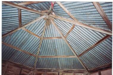
Photograph - Colour photograph, Colour photograph of the rear of the Yendon Primary School 1994
Yendon Primary School operated as a State School from 1877 and ceased operating in 1993. The School initially operated as the Buninyong East Common School from 1864.The children of railway workers from the Ballarat- Geelong railway would have formed much of the opening enrolment of the school.Colour photograph showing the internal roof structure of a six sided shelter shed in the grounds of the former Yendon Primary School 1994Yendon Primary School 1994 Shelter Shed Roof (internal)education, yendon, state schools -
 Bendigo Historical Society Inc.
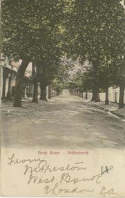
Postcard - Alice McGregor Postcard Collection, 1900 - 1920
Alice McGREGOR Born: 1908; unknown parents. Possibly adopted by the Salter family? Electoral Roll 1936: Highland Terrace Kangaroo Flat. Alice Mary Salter and William Robert Salter living together; presumed to be sister and brother. William Robert Salter was killed in a MVA in Bendigo in 1937 aged 26. In Victoria in 1938, Alice Mary Salter married James Thomas McGregor (born Victoria 1917, died Victoria 1983, buried Fawkner Cemetery) Lived: 1968; 22 Wade Street Golden Square Alice McGregor Died: 1999 aged 91 at Anne Caudle Centre, Bendigo Buried: Kangaroo Flat Cemetery See additional research. Postcard Album of Alice McGregor contained 86 post cards.Postcard Album of Alice McGregor containing 86 post cards. See 1400 Colour photo of Herte Street, Stellenbosch, South Africa. Tree lined avenue with houses either side. Addressed to Miss A. Stapleton, Arcade, Bendigo, Victoria, Australia Sender - M. Preston, West Bank, East London, S.A. Stamp date Sept. 28, 1905 postcard, collector, alice mcgregor -
 Port Fairy Historical Society Museum and Archives
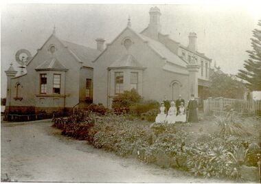
Photograph, Pt Fairy Hospital looking east 1890, 1890
The land for this building was granted to the Benevolent Society by James Atkinson in 1850. Tenders were called for a new "Benevolent Asylum" in 1855, the foundation stone having been laid and by 1856 the first part of the Hospital was completedBlack and white photograph New addition to the hospital with i’ts bay windows. 5 women and two men posed to the sidehospital, health service, nurses, bay window -
 Bendigo Historical Society Inc.
Photograph - T C WATTS & S0N COLLECTION: RUSSELL AND OLINDA STREETS, BENDIGO, 1930
In 1931 electoral rolls, Eric Robert Kevil (1901- 23/5/1980) and his wife lived at 129 Russell St. He had married Edna May Cornish in 1921. By 1943 they had both moved to 77 Valley Pde., Camberwell.Black and white photograph mounted on rectangular brown board. House, pale weatherboard with rough cast above. Corrugated iron roof, one chimney, shingles in gable over verandah, diamond leadlights, bow window L.H., recessed front door rough east surround and pillars to verandah, concave top to verandah wall. Paling side and rear woven wire front and near boundary, lintel over front gate, letterbox. Written on back of photoboard ' Mr. Kevill's Russell and Olinda St., built to order £850 sold, 15.6.34' Date Stamp on back '11 April 1930'Frank A. Jeffree, Bendigorussell street, e.r. kevil, russell street bendigo, t.c. watts and son -
 Ballarat Tramway Museum
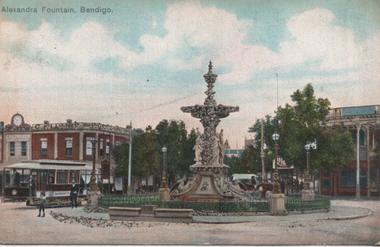
Postcard, "Alexandra Fountain Bendigo", 1900s
Printed postcard with a coloured image of the Alexandra Fountain, Bendigo, Charing Cross looking North East. An ESCo tram is on the left side, but the number is not visible. In the background are the building for J R Edwards which has a large clock on top and C Plumbe.Demonstrates a Bendigo postcard featuring the Alexandra Fountain and buildings at Charing Cross.Postcard colour - divided back - used addressed to a person at the Diorama Coy. Glitter or sparkles have been added to the postcard around the base of the fountain and on the fountain itself.tramways, trams, bendigo, alexandra fountain, charing cross, esco -
 Moorabbin Air Museum
Map (Item) - AAF Cloth Map- Southwest Pacific Area: Nos. 22,25 & 26
-
 Ballarat Tramway Museum
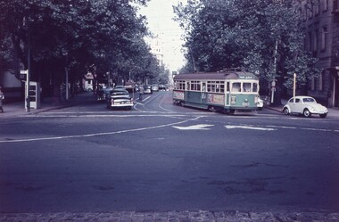
Photograph - Colour Photograph/s, Carolyn Dean, 3/11/1990 12:00:00 AM
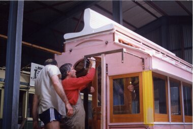
Colour photo of Horse Tram No. 1 within depot with John Phillips and Warren Doubleday working on the fitting of the east end sliding door. The staircase support bracket has been fitted as well. Not known who was holding the door on the other side. Tram body has been undercoated and some yellow paint has been applied to one of the corner pillars. Taken on 3.11.1990, Carolyn Dean, on Fujicolour paper.On rear "159.1 3.11.1990, Carolyn Dean Photo" in blue inkhorse tram no. 1, tramcars, reconstruction, btps, tram 1 -
 Bacchus Marsh & District Historical Society
Photograph, Court House Main Street Bacchus Marsh 1883
The Court House in Main Street Bacchus Marsh was built in 1858 using local sandstone. It opened in 1859. It has been used for jury trials, a Court of Petty Sessions, a County Court and a Crown Land sales office. Other uses included an office for the Registrar of Births and Deaths, a Dairy Inspectors office from 1863-1865, and as meeting rooms for the Bacchus Marsh Roads Board, a forerunner of the Shire Council. It was also used by the Bacchus Marsh Shire Council for its offices until at least 1884. In more recent years it has functioned as a Magistrates Court with weekly court sessions. Small sepia unframed photograph on card with gold border framing photograph. Housed in the album, 'Photographs of Bacchus Marsh and District in 1883 by Stevenson and McNicoll'. The view of the Court House building is seen from the northern side of Main Street looking south or south-east. Three men are standing in the street in front of the building. The men on the left and the right wearing police helmets appear to be police officers. The man in the middle is in civilian clothes and might be an officer or employee of the Court House. He has his dog with him. A white picket fence runs along the front of the building. The front courtyard of the building has been renovated since, but this building still operates as a court house.On the front: Stevenson & McNicoll. Photo. 108 Elizabeth St. Melbourne. COPIES CAN BE OBTAINED AT ANY TIME. On the back: LIGHT & TRUTH inscribed on a banner surmounted by a representation of the rising sun. Copies of this Portrait can be had at any time by sending the Name and Post Office Money Order or Stamps for the amount of order to STEVENSON & McNICOLL LATE BENSON & STEVENSON, Photographers. 108 Elizabeth Street, MELBOURNE. stevenson and mcnicoll 1883 photographs of bacchus marsh and district, courthouses, bacchus marsh court house -
 Kew Historical Society Inc
Work on paper - Sepia Wash & Ink, G B Richardson, Creek and Old Watering Stage, on the Yarra, East Collingwood, 1854, 1854
Blind Creek was located between the Abbotsford Convent and what is now the Collins Bridge in Studley Park. In an 1858 map of East Collingwood by Clement Hodgkinson, in the State Library of Victoria, one can see how the creek was originally a significant landmark in Collingwood; remaining vacant land until a barrel drain enclosed it. The area was later filled in, surveyed and developed. The position where Blind Creek entered the Yarra was in the immediate vicinity of Hodgson’s Punt, which had linked Kew to the other side of the Yarra from 1839. The Punt was purchased by the Colonial Government in 1852 and was in use until the opening of the Studley Park Road (Johnston Street) Bridge in 1858 made its continued use redundantThe point of view selected by the artist for the watercolour is from the banks of Blind Creek in East Collingwood, looking across the Yarra to the Kew side of the river.Inscribed verso 'Creek and Old Watering stage, on the Yarra East Collingwood 1854 / Trees, stage, &c have long since disappeared / [Artist Signature] / FT 110 / Creek itself now being filled in 1903.gb richardson, blind creek - abbotsford, yarra river - abbotsford (vic) - kew (vic), colonial artists, australian art - 19th century, george bouchier richardson -
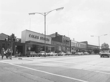 Ringwood and District Historical Society
Photograph, Maroondah Highway Central, Ringwood. Shops in Maroondah Highway looking east from Ringwood Street. c1974
Black and white photographImage shows shops on north side of the road including Coles Stores, State Savings Bank, and Midway Arcade. -
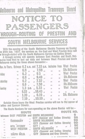 Melbourne Tram Museum
Document - Photocopy, Melbourne & Metropolitan Tramways Board (MMTB), "Notice to Passengers - Through routing of Preston and South Melbourne Services", Originals - 1937
Set of three photocopied notices onto foolscap, heat sensitive paper, c1937, with details of alterations due to revised or new tram routes. All signed S. M. Richardson as Manager. .1 - "Notice to Passengers - Through routing of Preston and South Melbourne Services" Gives new route numbers. Dated 10th July 1937. .2 - "Notice to Passengers - Extension of Brighton Cemetery tramway via Hawthorn Road, to Point Nepean Rd, East Brighton" - November 1937, part of copy missing on left hand side. Opening date to be 5th December 1937. .3 - "Notice to Passengers - Collingwood cable tramway bus service on Sunday mornings", gives details of bus times and frequency - and commencement times for the cable trams. Dated 3rd November 1937.trams, tramways, preston, south melbourne, east brighton, hawthorn rd, opening, routes, buses, cable trams, collingwood -
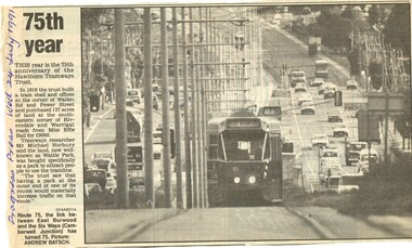 Melbourne Tram Museum
Newspaper, Burwood Press, "75th year", 24/07/1999 12:00:00 AM
Newspaper clipping - from the Progress Press, 24th July 1991, titled "75th year" reporting on the 75th anniversary of the Hawthorn Tramway Trust - HTT. Refers to notes supplied by Michael Norbury, Has a photo of Z15 on route 75 to East Burwood in Burwood Highway. Photo by Andrew Batsch.On left hand side in ink "Progress Press Wed 24 July 1991"trams, tramways, htt, burwood highway, z class, tram 15 -
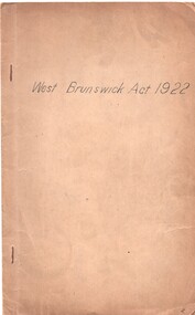 Melbourne Tram Museum
Document - Personal Papers, Victorian Parliament, "West Brunswick Act 1922", 1922
Folder - brown card cover, stapled with a copy of the Victorian Act of Parliament No. 3243 that authorised the construction of the Electric tramway to West Brunswick (East Coburg line). Dated 21/12/1922."H. S. McComb" written on the top right hand corner in ink, underlining of various words in red ink and two sets of hand written notes on the right hand side of page 3.trams, tramways, tramways, acts of parliament, mmtb, east coburg, construction -
 Melbourne Tram Museum
Photograph - Set of two Colour Prints, Lloyd Rogers, 8/02/1998 12:00:00 AM
Set of two colour prints of Opening of East Burwood tramway extension to Blackburn Road, 8/7/1993. .1 - Opening ceremony with local Mayor, Alan Brown (Minister of Transport) and Ian Dobbs (CEO of Public Transport Corp.) .2 - general scene - at the opening with 180 and other vintage trams at the event. Includes Carolyn Dean and John Phillips on the left hand side of the photograph.Each photo has written in ink on the rear the details and date of the photograph and the negative number - see image i3, have the photo number on the rear.trams, tramways, east burwood, opening, blackburn rd, vintage trams, tram 180 -
 Melbourne Tram Museum
Document - Personal Papers, John Prideaux, "Details of the Comeng Trams", 1975
Handwritten draft on ruled Foolscap folio sheet, folded in half and written on three of the four sides, titled "Details of the Comeng Trams". Could have been written by John Prideaux for the AETA Electric Traction. Gives details of the tram, designer, seating, doors, ASEA Equipment, motors, control equipment, braking, resilient wheels, testing. The final page is about the history of the East Preston and East Brunswick Routes.trams, tramways, z class, new trams, w7 class, 1041, prototype tramcar, bogies, trucks, asea, brakes, comeng, electric traction, aeta -
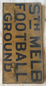 Melbourne Tram Museum
Sign, Melbourne & Metropolitan Tramways Board (MMTB), "Fitzroy Football Ground", "Sth Melb Football Ground", 1950's
Sign, painted onto a MMTB auxiliary destination board of the type that could hang on the front of a Melbourne tram car with the words "Fitzroy Football Ground" and "Sth Melb Football Ground" Black letters on a yellow background. The bottom right hand corner of the Sth Melbourne face has the letters "E.P." indicating the depot that it belonged to - East Preston. South Melbourne Football Ground Metal sign, fitted with metal hanging brackets, riveted to sign on both sides. Manufactured by rolling the outer edges over a 4mm diameter steel rod.trams, tramways, football, fitzroy, south melbourne, signs, auxiliary board -
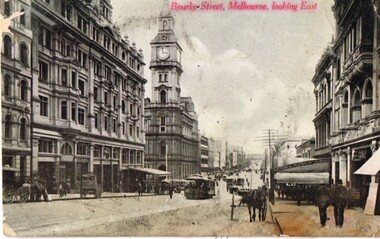 Melbourne Tram Museum
Postcard, Marlborough Series, "Burke St Melbourne Looking East", c1910
Postcard photo of Bourke St looking east from about half way between Elizabeth and Queen St with the Melbourne GPO, Post Office in the middle of the photograph, along with a number of horse drawn vehicles and cable trams. mid 1900's (c1905). Divided back with spaces for Correspondence, address and stamp. On right hand side in red "Marlborough Series" (Printed in Australia)trams, tramways, cable trams, bourke st, horse drawn vehicle -
Melbourne Tram Museum
Newspaper, The Herald, “Special tram gets a lift”, 1967
... , windows flanked with white fretwork with advertising on both sides... Trams tramways Advertising trams East Preston tram 1024 “Special ...“Special tram gets a lift” The Herald – 1967 Photo and text Tram # 1024. 150th anniversary of Bank of NSW One of the Tramway's most modern vehicles. Roof and wheels painted white, windows flanked with white fretwork with advertising on both sides. Running on East Preston - City route (88) Tram rented for 1 month at undisclosed cost.trams, tramways, advertising trams, east preston, tram 1024 -
 Melbourne Tram Museum
Administrative record - Depot List, Public Transport Corporation (PTC), "PTC Allocation of tramcars as at 01 December 1994", 1/12/1994
Gives tram allocations for Brunswick, Camberwell, East Preston, Kew, Glenhuntly, Essendon, Malvern and South Melbourne. Also provides notes on tram with poles and pantographs.Yields information about tramcar allocation between various depots and workshops.Set of five double sided A4 photocopied sheets titled "PTC Allocation of tramcars as at 01 December 1994", trams, tramways, tramcars, ptc, lists, depots, depot allocation -
 Melbourne Tram Museum
Photograph - Black and white - Flinders St, looking west from Swanston St, c1905
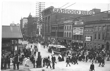
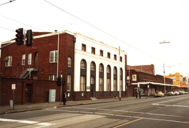
Photograph of Flinders St looking east from Swanston St - shows the entrance to Flinders St station prior to the construction of the current building. In the view are one cable tram, many pedestrians and some horse-drawn vehicles. A hoarding on the left hand side possibly indicates work is underway on the new station building. A sign on the pole advises that cable trams went to Spencer St for a penny and for 3d to Port Melbourne or South Melbourne. In the background are buildings for Sargood Bros, Thomas Whitelaw Home Decorators, The Hub, a sign on the Young & Jackson Hotel advertising a Women's Exhibition. There is a telephone pole line on the south side of Flinders St.Yields information about Flinders St, c1905.Black and white photograph on paper.In pencil on rear "163 OB"trams, tramways, cable trams, flinders st, flinders st station -
 Melbourne Tram Museum
Slide - Set of 3, Keith Caldwell, 9/03/1960 12:00:00 AM
Set of 3 Agfa Colour slide, cardboard mount, by Keith Caldwell of:- .1 - SW6 889 turning from Collins St into Gisborne St, route 42, Month Albert. Has a Stonefell advert on the sides and others which are not readable. Dated 10 March 1960. .2 - W5 767 east bound in Collins St, east of Swanston St showing East Preston - Bell St, route 91A and SW6 895 westbound, showing Hanna St Depot?. Moomba Street decorations in the view. Has the Town Hall and the Manchester Unity Building. Dated 9 March 1960. .3 - W2 475 east bound, as for .2 showing East Preston Bell St, route 9A. Note the tramcar number is above the headlight. Three other trams are inbound, the last one showing route 47, City. Dated 9 March 1960.hand stamped "9 Mar '60"trams, tramways, collins st, mont albert, route 42, gisborne st, town hall, route 9a, hanna st depot, east preston, moomba, w2 class, w6 class, sw6 class, w5 class, tram 889, tram 767, tram 895, tram 475 -
 Melbourne Tram Museum
Map, Melbourne & Metropolitan Tramways Board (MMTB), Set of 15 tram route maps, 1977 to 1979
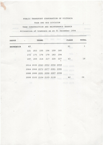
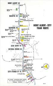
Series of 15 colour route maps for various tram lines or groups of tram lines for the MMTB. Some have the Transport Information Centre telephone printed on them, others have a label stuck on. Some are finished with a plastic laminate finish on either one or both sides. Show the major cross streets, parks, schools, other tram routes, major stop numbers and railway lines. Two copies of each held unless noted otherwise. .1 - Mont - Albert City - R11/77, shows routes 43. 47. 45. 44 .2 - Malvern, East Malvern, Carnegie and East Brighton Tram Routes (from St Kilda Junction) - R1/79 - shows routes 5, 3, 67, 66, 61, 62 and 64. .3 - Swanston St tram guide - R1/79 - lists all routes and route numbers that branch or cross Swanston St between Grattan St and St Kilda Junction. .4 - St Kilda Rd Tram Routes R12/77 - details South Melbourne Beach, route 1 and route 2 and St Kilda Beach routes 15, 16 and 55 otherwise shows were the various routes branch off St Kilda Road. Copy 1 has "P14909" in pencil in the bottom right hand corner. .5 - Kew - St Kilda Beach - R1/79 - Route 69. .6 - Footscray - Moonee Ponds - R3/81 - Route 82 .7 - Flinders St tram routes - R5/78 - North Balwyn, East Burwood, routes 48, 40, 41, Hartwell, 28, 74 and 75 .8 - William St tram routes - Route 55, 56 and 63 - South Melbourne Depot and Domain. copy 2 has "P14913" in bottom right hand corner. .9 - Toorak Camberwell and Glen Iris tram routes with Camberwell Junction and Malvern Town Hall, R1/79, routes 8, 7, 6, 72 and 73 shown. .10 - Swanston St tram routes - R12/77 - shows all the Swanston St routes, including East Coburg and Moreland. .11 - Bourke St tram routes - R4/77 - East Brunswick Blyth St and East Preston Tyler St and intermediate routes, routes 95, 96, 97, 90, 89 and 88. .12 - as for .11, dated 1/85, showing extension to La Trobe University - has Metropolitan Transit logo. Only 1 copy held. Also shows route 92 and 87. .13 - Batman Ave tram routes - R9/77 - Wattle Park, North Richmond and Prahran - routes 70, 71, 78 and 79. .14 - City route guide - R9/77 - showing all route numbers and destinations that passed through the CBD. .15 - Elizabeth St tram routes - R12/77 - Essendon Airport, West Maribyrnong, North Coburg lines, routes 50, 58, 60, 54, 57, 52. 49, 59, 18, 20 and 19. Copy 1 has "P14905" in pencil in bottom left hand corner.trams, tramways, maps, route guide, route numbers, routes, mont albert, route 43, route 47, route 45, route 44, route 42, malvern burke rd, east preston, carnegie, east brighton, south caulfield, route 5, route 3, route 67, route 62, route 64, route 66, glenhuntly tram depot, swanston st, st kilda rd, south melbourne beach, st kilda beach, route 1, route 2, route 15, route 16, route 55, kew- cotham road, route 69, route 79, route 82, footscray, moonee ponds, flinders st, north balwyn, kew, east burwood, burwood, hartwell, richmond, route 48, route 40, route 41, route 28, route 74, route 75, route 56, route 63, william st, west coburg, toorak, camberwell, glen iris, malvern town hall, route 72, route 73, route 7, route 8, bourke st, route 6, route 95, route 96, route 97, route 90, route 89, route 89, east preston, east brunswick, la trobe university, clifton hill, route 92, route 87, route 70, route 71, route 78, route 79, north richmond, prahran, wattle park, essendon airport, west maribyrnong, north coburg, route 50, route 58, route 60, route 54, route 57, route 52, route 49, route 59, route 18, route 20, route 19, batman ave -
 Melbourne Tram Museum
Map, Melbourne & Metropolitan Tramways Board (MMTB), Set of 8 bus route maps, 1977 to 1979
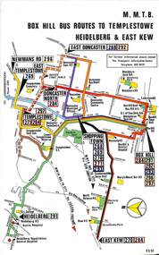
Series of colour route maps for various bus or groups of tram lines for the MMTB. Some have the Transport Information Centre telephone printed on them, others have a label stuck on. Some are finished with a plastic laminate finish on either one or both sides. Show the major cross streets, parks, schools, other tram routes, major stop numbers and railway lines. .1 - Box Hill bus routes to Templestowe - R38/82, Heidelberg and East Kew, includes Doncaster, Shoppingtown and Newmans Road. .2 - Clifton Hill - R2/79 - Elsternwick, Point Ormond and St Kilda Junction .3 - Footscray, Sunshine, Deer Park, Nth Altona, Fishermen's Bend, Highpoint and Williamstown Road - R2/79. .4 - Bulleen - City - Port Melbourne - Garden City Bus Route, including Kew, Collingwood - R6/78 .5 - City - Warrandyte and East Doncaster including Newmans Road, Templestowe, East Doncaster, Donvale, Shopping town, and Kew. R3/82. .6 - West Heidelberg, La Trobe University, Northland - R3/81 .7 - Box Hill, Ringwood to East Doncaster and Warrandyte, Park Orchards, North Blackburn R3/82. .8 - Geelong - Herne Hill, Rollins Road, Donnybrook Rd, North Shore and Corio Villagetrams, tramways, maps, route guide, route numbers, routes, buses, box hill, templestowe, doncaster, east kew, heidelberg, clifton hill, point ormond, elsternwick, footscray, sunshine, deer park, north altona, fishermen's bend, highpoint, williamstown rd, bulleen, kew, collingwood, port melbourne, garden city, warrandyte, donvale, la trobe university, northland, ringwood, park orchards, mitcham, blackburn, geelong -
 Melbourne Tram Museum
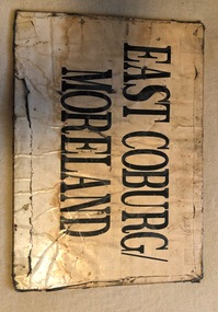
Sign, Melbourne & Metropolitan Tramways Board (MMTB), "Sth Melb Beach" & "East Coburg / Moreland", c1990?
Sign - sheet of plywood, with paper destinations taped to the sheet for an auxiliary destination board - "Sth Melb Beach" & "East Coburg / Moreland" on each side. Appears to be "depot made". Has two small holes in the top corners.trams, tramways, destination indicators, south melbourne beach, east coburg, moreland, auxiliary board -
 Melbourne Tram Museum
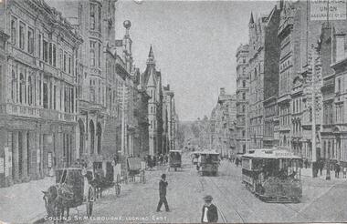
Postcard, "Collins St Melbourne looking East", 1900's
Postcard - silver finish known as "Collotype" - view of looking east along Collins St from near the intersection of Market St. Has a number of cable cars in the view, the first one having the destination of Spencer St. Has a number of horse drawn vehicles, parked or tethered on the wrong side of the road. Card titled "Collins St Melbourne looking East" Postcard has a divided back with space for stamp, address and correspondence. In the top centre is a start with an "O" in the centre. .1 - reproduction black and white photograph, collected by Keith Kings3392.1 - has "20c" in pencil in the top left hand corner and a TMSV Sales stamp on the rear.trams, tramways, cable trams, market st, collins st, buildings, horse drawn vehicle -
 Melbourne Tram Museum
Photograph - Set of 16 Colour Photograph/s, Public Transport Corporation (PTC), May. 1991
Set of 16 colour prints of tram depots and/or associated land holdings. All dated May 1991, unless noted otherwise. .1 - Brunswick depot looking from Sydney Road. .2 - ditto - car parking area adjacent to depot .3 - ditto - from railway line looking at the depot car shed .4 - East Preston depot from the south east. .5 - East Preston depot car park cnr. David St and Plenty Rd. .6 - Building adjacent to the car park, BTR automatic Transmission specialists which was owned by the PTC. .7 - House at 63 David St Preston, assumed owned by the PTC - dated 13-3-1986 .8 - Camberwell depot - car shed. .9 - ditto - entry and office. .10 - Office from the depot side. .11 - Malvern depot - No. 1 shed and office .12 - Malvern depot - No. 2 shed .13 - Coldblo road with tram track .14 - House at 28 Stanhope St which was PTC owned. .15 - rear of above. .16 - Stanhope St tramway hall.1 - .3 -"Brunswick Tram depot May 1991" in ink on the rear. .4 - "East Preston Tram Depot May 1991" .5 - "East Preston depot car park cnr. David St and Plenty Rd. May 1991" .6 - "Factory at 261 - 267 Plenty Rd Preston Tramways owned building" .7 - "63 David St Preston 13-3-86 (1pm) .8 - 10 - "Camberwell Depot May 1991" 11 - 13 "Malvern Depot May 1991" .14 and .15 - 28 Stanhope St Malvern May 1991" .16 - "Stanhope St Hall Malvern May 1991"trams, tramways, camberwell depot, east preston depot, malvern depot, brunswick depot, property, stanhope st -
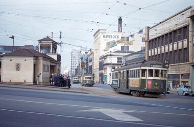
 Melbourne Tram Museum
Slide, Keith Caldwell, 10/03/1966 12:00:00 AM
Agfa colour blue white plastic mount, photo by Keith Caldwell of SW6 947, in Swanston St, about to cross Collins St, running a route 64 to the city. In the side a W2 southbound. IN the photo is the building that was later demolished for the City Square. A white van is completing a hook turn. Street decorations for the Moomba festival. Queen Victoria Building on the south east corner of Collins and Swanston. 10/3/1966In ink "10 iii 66"trams, tramways, collins st, sw6 class, swanston st, route 64, moomba, hook turn, tram 947 -
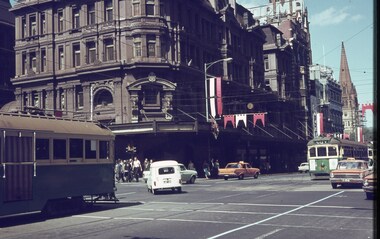
 Melbourne Tram Museum
Slide - Set of 2, John Webster, 21/07/1959 12:00:00 AM
Set of two Colour slides, Kodak, white cardboard of trams of trams at the Victoria St / Swanston St shunt. 21-7-59. .1 - W2 340 showing East Malvern Darling road opposite the signal box followed by W2 showing route 4. Has a large number of men and school boys at the stop. In the view is a "No Entry" sign. In the background is the Ansett ANA building and a building advertising Havelock Tobacco. The tram has a Pimms No. 1 advert. .2 - W2's 550 (with a Castrol sign), 340 - as above and 358 (route 8, Toorak - Glenferrie Road) in the Victoria St shunting area. Has the Army hall behind the trams.Hand writing on rear in ink; "21-7-59 - KFB2 - TRACK - KEV - Swanston St near Victoria St Melbourne" "21-7-59 - KFB3 - TRACK - KEV - Trams in Victoria St Melbourne" Both slides have the speed and the f reading on the left hand side.trams, tramways, victoria st, swanston st, signal box, route 4, route 8, route 4d, east malvern, tram 550, tram 358, tram 340