Showing 31857 items matching "franfurt-am-main"
-
 Stawell Historical Society Inc
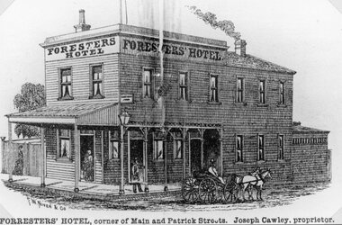
Drawing, Mr J Crawley Foresters’ Hotel at the corner of Main Street Stawell & Patrick Street from the P.C. News Supplement 1888 -- Sketch
Foresters’ Hotel J. Cawley corner 186 Main Street and Patrick Street from P.C. News Supplement 1888stawell businesses -
 Stawell Historical Society Inc
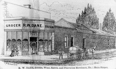
Drawing, Mr R. W. Dane Grocer & Baker on the corner Main Street Stawell & Layzell Street from the P.C. News Supplement 1888-- Sketch
R. W. Dane Grocer & Baker corner Main Street and Layzell Street from P.C. News Supplement 1888stawell businesses -
 Greensborough Historical Society
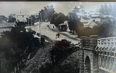
Photograph - Photograph (Framed), Blue stone bridge looking up Main Street Greensborough
Blue stone bridge looking up Main Street Greensborough. Bridge lower right and Marble Hall upper left.From the John Mackey collection. this item was displayed at the offices of Ryan, Mackey and Kelly, solicitors, Main Street Greensborough.Timber-framed photograph of view of Greensborough, black and white.greensborough, john mackey, blue stone bridge, marble hall -
 Stawell Historical Society Inc
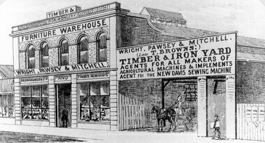
Drawing, Wright, Pawsey & Mitchell in Main Street Stawell from the P.C. News Supplement 1888 -- Sketch
Wright. Pawsey & Mitchell Main Street Stawell from P.C. News Supplement 1888 Later years occupied by Coles.stawell businesses -
 Stawell Historical Society Inc
Drawing, Mr W. Whiteside & Co., Tailors in Main Street Stawell from the P.C. News Supplement 1888 -- Sketch
W. Whiteside & Co. Tailors Main Street beside Town Hatt Hotel from P.C. News Supplement 1888Line Drawing of three fronted shop with four bay verandah. Four wheel, two horse buggy in front and number of people on verandah. stawell businesses -
 Stawell Historical Society Inc
Photograph, Telford Family Photograph Album including the Telford family business of Hay Provisions and General Grocer in Main Street Stawell
Telford Family Photograph Album. Telford family had business Hay Provisions and General Grocer main Street Stawellstawell -
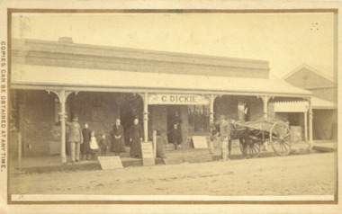 Bacchus Marsh & District Historical Society
Photograph, George Dickie Bakery Main Street Bacchus Marsh 1883
George Dickie arrived in the Bacchus Marsh area around 1857. In 1863, he married Ellen Ross Anderson, and after five years of farming in Coimadai, they moved into Bacchus Marsh and established a business. In 1866 he bought the bakery business which had been established by James Boatwood and later conducted by William Watson. This business was in Main Street and is shown in this image during the time it was owned and operated by George Dickie. Ellen and George Dickie had seven children, two sons and five daughters. In his later years he changed the business into a general store and also engaged in grain dealing. He died in 1904 but the business was carried on by his sons until sold in March 1916 to a Charles Medling from Numurkah. The building was later demolished in 1927 to make way for four new shops.Small sepia 'carte de viste' style unframed photograph on card with gold border framing photograph. Housed in the Jeremeas Family Album which contains photographs of Bacchus Marsh and District in 1883 by the photographers Stevenson and McNicoll. The picture shows the business of George Dickie which was located in Main Street Bacchus Marsh. The building is a brick or stone structure with a verandah along the entire frontage of the building. Standing in front of the building is a group of adults and children. On the far left is a man wearing a dress coat and hat. He is possibly Mr. George Dickie the owner of this business. To his left are some younger and older children, and a woman, possibly Mrs DIckie. In the background in the doorway is a young boy with woman behind him. On the right of the picture on the street is a man standing alongside a horse and cart. Some advertising signs are leaning against the shop, footpath and verandah pillar. One of them says 'Chaff, Oats, Bran'. Printed On the front: Stevenson & McNicoll. Photo. 108 Elizabeth St. Melbourne. COPIES CAN BE OBTAINED AT ANY TIME. On the back: LIGHT & TRUTH inscribed on a banner surmounted by a representation of the rising sun. Copies of this Portrait can be had at any time by sending the Name and Post Office Money Order or Stamps for the amount of order to STEVENSON & McNICOLL LATE BENSON & STEVENSON, Photographers. 108 Elizabeth Street, MELBOURNE. stevenson and mcnicoll 1883 photographs of bacchus marsh and district, bakeries, shops bacchus marsh, george dickie 1831-1904, dickie family bacchus marsh -
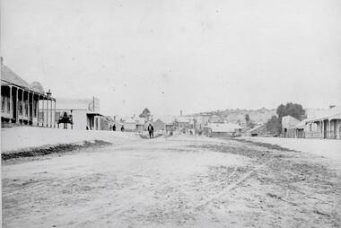 Stawell Historical Society Inc
Photograph, Upper Main Street Reefs looking East towards Big Hill from the front of Joyce's Hibernian Hotel 1866
Upper Main Street Reefs looking East towards Big Hill taken from front of Joyce's Hibernian Hotel . Part of a collection of Photographs by Mr. O.G. Armstrong as commissioned by the Shire of Stawell for the Inter-colonial and Paris Exhibition in Melbourne in 1866. This scene was taken in 1866 in Main Street from in front of Joyce’s Iberian Hotel on the left, the site of the present townhall. It is looking uphill and eastward with Big Hill in the far background. The Hibernian Hotel was built on Commercial Street Pleasant Creek Goldfields in 1858 and was moved to Main Street Reefs, the present site of the Town Hall by Mr. & Mrs. Joyce. It was later destroyed by fire and the Town Hall built on its location. Street scene with buildings in distance and Big Hill in far distance.stawell streetscape -
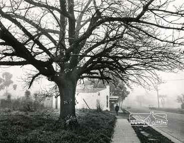 Eltham District Historical Society Inc
Photograph, Old Oak Tree near cnr of Franklin Street and Main Road, Eltham
Black and white photograph looking south down Main Road at a fog-shrouded view of an old large oak tree which still stands at the entrance to the Eltham Hotel car park. Antiques store in centre now Cafe Zen Den (2017) and across the road is the Mobil Service Station, now a commercial business centrepioneers and painters, main road, franklin street, eltham -
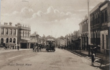 Kew Historical Society Inc
Postcard, Main Street, Kew, c.1890
The Kew Historical Society's Pictures Collection is comprised of photographs, postcards and original works of art. The postcards include original (mainly) images dating from the 1900s to the present. A number of postcards, some of which have numerous variants, were published as parts of series. Others are original images customised as postcards. Many of the postcards in the collection depict places within the suburbs of Kew and Kew East. Others depict locations in Victoria or internationally. A monochrome postcard showing Main Street [High Street], Kew, looking south west from near its junction with Cotham Road, showing: Ryan’s Council Family Hotel, T. G. Jellis (baker, confectioner), Herbert King (undertaker), L. Merritt (boot warehouse), horse tram, horse drawn vehicles and pedestrians.Post card text addressed to Miss Newell of Balmain.high street - kew, cotham road - kew, tramways - kew -
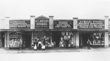 Ringwood and District Historical Society
Photograph, Maroondah Highway Central, Ringwood. Beilby Stores - Main Street, Ringwood (Opposite Railway Station),1924
Black and white photograph Printed below photograph: "A.C. Beilby. General Stores. Ringwood. Telephone 4", and "Beilby Stores, Main St. (Opposite Railway Station) 1924". Image shows a group of shops with 'A.C. Beilby Stores' written above veranda. -
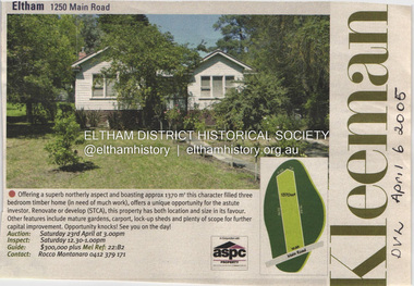 Eltham District Historical Society Inc
Document - Property Binder, 1250 Main Road, Eltham
Newspaper advertisement: Diamond Valley Leader, 6 April 2005, Kleeman real estate sale of 1250 Main Road Eltham.main road, eltham, property, kleeman real estate -
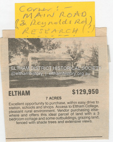 Eltham District Historical Society Inc
Document - Property Binder, 1480 Main Road, Eltham
Home of the Dodkins family Newspaper advertisement: undated, Sale of 1480 Main Road, 7 acres, for $129,950, photograph of existing cottage.main road, eltham, property, research (vic), dodkins family home -
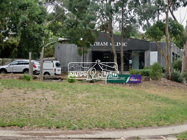 Eltham District Historical Society Inc
Photograph, Jim Connor, Avenue of Honour, Main Road, Eltham, 14 Jan 2017
Eltham Gateway, Eltham Clinic, 700 Main Road, Elham viewed from Wingrove Park Trail opposite Dalton StreetTomorrow's history documented todayeltham, jim connor collection, main road, eltham gateway, avenue of honour, dalton street, eltham clinic -
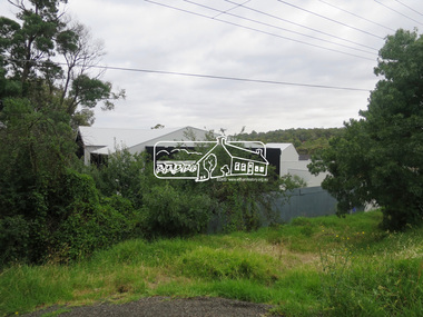 Eltham District Historical Society Inc
Photograph, Jim Connor, Main Road, Eltham, 14 Jan 2017
Eltham Gateway, View of development at 825 Main Road, Eltham The development commenced in early 2017 and is still in progress as of August 2021Tomorrow's history documented todayeltham, jim connor collection, main road, eltham gateway -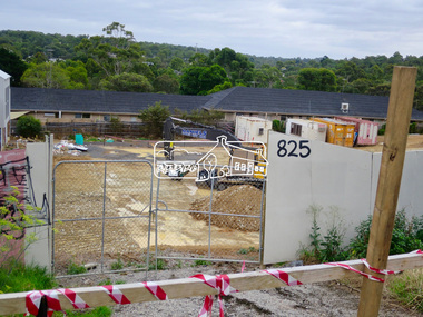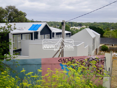
 Eltham District Historical Society Inc
Photograph, Jim Connor, Main Road, Eltham, 14 Jan 2017
Eltham Gateway, Our Lady Help of Christians - Eltham, 866 Main Rioad, Eltham viewed from corner of Panther PlaceTomorrow's history documented todayeltham, jim connor collection, main road, eltham gateway, henry street, our lady of help christians church -
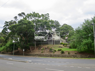
 Eltham District Historical Society Inc
Photograph, Jim Connor, Main Road, Eltham, 14 Jan 2017
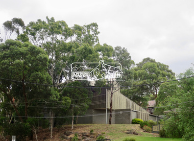
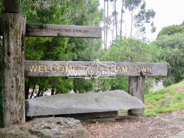
Eltham Gateway, Eltham Town Sign in front of former Eltham Shire Council Office carpark, 895 Main Road, ElthamTomorrow's history documented todayeltham, jim connor collection, main road, eltham gateway, eltham town, sign, welcome sign -
 Eltham District Historical Society Inc
Photograph, Jim Connor, Main Road, Eltham, 14 Jan 2017
Eltham Gateway, Unit complex, 836 Main Road, Eltham at corner of York Street - site of the original old bakehouse and shopTomorrow's history documented todayeltham, jim connor collection, main road, eltham gateway, york street -
 Eltham District Historical Society Inc
Photograph, Construction of new bridge over the Plenty River, Main Road, Lower Plenty, c.Aug. 1966
Construction of the Main Road bridge over the Plenty River. Includes structural members, construction personnel, vehicles and a Clarke mobile crane.Local significanceBlack and white printlower plenty, main road, plenty river, bridge, bridge construction, civil engineering, cranes, mobile cranes -
 Eltham District Historical Society Inc
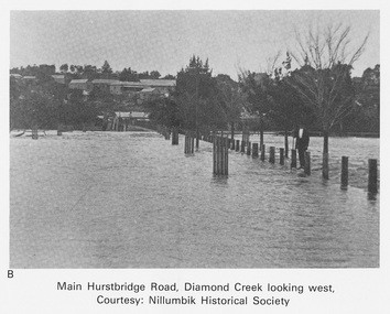
Work on paper (Sub-Item) - Photograph, Main Hurstbridge Road, Diamond Creek looking west
Undated black and white photograph of Main Hurstbridge Road, Diamond Creek in flood looking west. Nillumbik Historical Society collectionflood, diamond creek, nillumbik historical society -
 Greensborough Historical Society
Photograph - Photograph - Digital Image, Main Street bridge Greensborough 1970s, 1970s
A colour photograph of the corner of Para Road and Main Street Greensborough in the 1970s, during the duplication and construction of the bridge over the Plenty River.Digital copy of colour photograph.main street greensborough, para road greensborough, plenty river bridge -
 Greensborough Historical Society
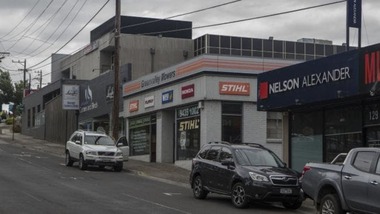
Photograph - Digital Image, Sandy Anton, Lower Main Street, March 2019, 2019_03
Photograph of lower Main Street area, taken in March 2019. Shows the Greensborough RSL, Green Valley Mowers and Nelson Alexander. Digital copy of colour photographmain street greensborough, greensborough rsl -
 Greensborough Historical Society
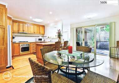
Advertising Leaflet, 4/415 Main Road Montmorency, 2013_04
4/415 Main Road Montmorency. 3 bedroom home on shared block, private sale, sold April 2013 for $515,000Real estate advertising leaflet, 1 sheet, printed in colour both sidesmain road montmorency -
Greensborough Historical Society
Memoir, O'Neill's Greengrocers Main Street Greensborough / Nancy Fowkes (nee O'Neill), 1953-1969
Nancy Fowkes (nee O'Neill) tells the story of her father's greengrocers shop in Main Street Greensborough from 1953 to 1969.A personal story of life in Greensborough.One page of text.bill oneill, oneill family, nancy fowkes, main street greensborough -
 Greensborough Historical Society
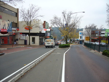
Photograph - Digital image, Noel Withers, Main Street Greensborough, looking North 2010, 04/06/2010
View of Main Street Greensborough near Para Road, looking North. Photograph taken by GHS member Noel Withers in 2010.Digital copy of colour photograph.main street greensborough, para road -
 Greensborough Historical Society
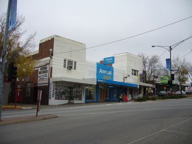
Photograph - Digital image, Noel Withers, Main Street looking east, 2010, 04/06/2010
View of Main Street Greensborough, near Para Road, looking East. Photograph taken by GHS member Noel Withers, 2010.Digital copy of colour photograph.main street greensborough, para road