Showing 5786 items matching "location"
-
 Mission to Seafarers Victoria
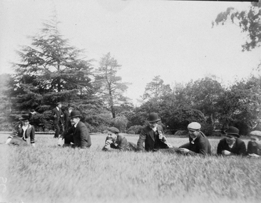
Photograph, Seamen laying on the grass
Same location as item 1843 and 1848Small monochrome photograph (faded) depicting outdoor gathering of seamen and LHLG member.picnic, lhlg -
 Mission to Seafarers Victoria
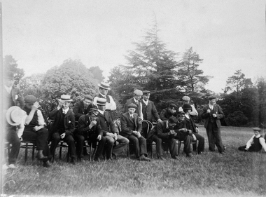
Photograph, Sailors' picnic
Same location as item 1843 and 1845 Small monochrome photograph (faded) depicting outdoor gathering of seamen.picnic, lhlg -
 Greensborough Historical Society
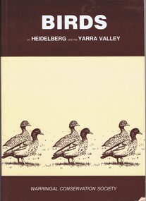
Book, Birds of Heidelberg and the Yarra Valley, 1981_
Bird lists and locations in the Heidelberg area115 p. paperback, buff-coloured paper, brown text and illustrations.native fauna, heidelberg, birds -
 Greensborough Historical Society
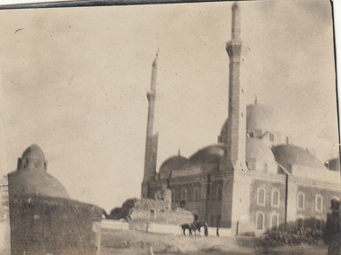
Photograph - Digital image, Charles Marshall et al, Mosque, 1918_
This photographs shows a mosque, location unknown.Digital copy of black and white photograph. No caption on this photographcharles marshall, world war 1 -
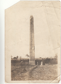 Greensborough Historical Society
Photograph - Digital image, Charles Marshall et al, Obelisk, 1918_
This photographs shows an obelisk, location unknown.Digital copy of black and white photograph. No caption on this photographcharles marshall, world war 1 -
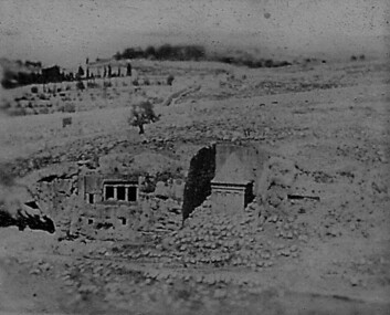 Greensborough Historical Society
Photograph - Digital image, Charles Marshall et al, Ruins along the way, 1917_
This photograph shows ruins (location not known)Digital copy of black and white photograph. No caption on this photographcharles marshall, world war 1 -
 Tatura Irrigation & Wartime Camps Museum
Photograph, Tatura picnic c 1935, 2001
Picnic of Tatura people in unknown location.tatura picnic c1935, photograph, people -
Clunes Museum
Map, Surface Geology Plan
Plans show various shaft locations.1 Photocopy of Plan Block 23/19 Scale 1 inch = 100 feet .2 Photocopy of Plan Block 19/19 Scale 1 inch = 100 feet .3 AERIAL PHOTOGRAPH WITH WORKINGS MARKED - LAMINATED.1 C-21 North Broken Hill Ltd Clunes Block 23/19 .2SOUTH CLUNES MINE Ltd Clunes Block 19/19north broken hill ltd, surface geology plan -
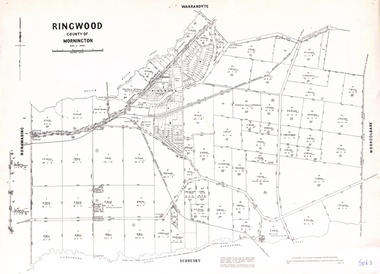 Ringwood and District Historical Society
Map - Parish of Ringwood, County of Mornington, Victoria, Original Land Owners
Laminated Parish map of Ringwood detailing original Land Owners' names, property locations and acreages. Details reproduced in 1957 by the Department of Lands and Survey, Melbourne, from original surveys of varying dates. -
 Eltham District Historical Society Inc
Flyer, 2018 Rotary Eltham Festival, 2018
Colour flyer promoting the 2018 Eltham Rotary Eltham Festival with dates, location and description of activities, logos of partners and internet links. The flyer also includes a prominent fireworks warning for pet ownerseltham festival -
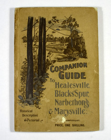 Marysville & District Historical Society
Book, The Atlas Press, Companion Guide to Healesville, Blacks' Spur, Narbethong & Marysville, 1904
A companion guide to Healesville, Blacks' Spur, Narbethong & Marysville. With photographs, information and a pull-out map.Paperback. Front cover has a drawing of a countryside outlook. The book contains 65 photographs and information relating to the locations listed on the front cover. There is a pull-out map located on the inside of the back cover.non-fictionA companion guide to Healesville, Blacks' Spur, Narbethong & Marysville. With photographs, information and a pull-out map.healesville, black spur, narbethong, marysville, victoria, history -
 Marysville & District Historical Society
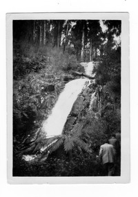
Photograph (item) - Black and white photograph, 1969
A black and white photograph of Steavenson Falls in Marysville in Victoria.A black and white photograph of Steavenson Falls in Marysville in Victoria. The Steavenson Falls is named after the Victorian Assistant Commissioner of Road and Bridges, John Steavenson who arrived in Victoria in the early 1860s.Stephen's/ Falls/ 1969 85-steavenson falls, stephen's falls, waterfalls, marysville, victoria, john steavenson -
 Marysville & District Historical Society
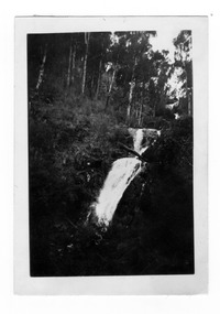
Photograph (item) - Black and white photograph, 1969
A black and white photograph of Steavenson Falls in Marysville in Victoria.A black and white photograph of Steavenson Falls in Marysville in Victoria. The Steavenson Falls is named after the Victorian Assistant Commissioner of Road and Bridges, John Steavenson who arrived in Victoria in the early 1860s.Stephen's/ Falls/ 1969steavenson falls, stephen's falls, waterfalls, marysville, victoria, john steavenson -
 Marysville & District Historical Society
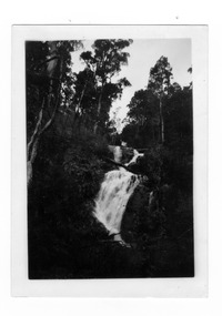
Photograph (item) - Black and white photograph, 1969
A black and white photograph of Steavenson Falls in Marysville in Victoria.A black and white photograph of Steavenson Falls in Marysville in Victoria. The Steavenson Falls is named after the Victorian Assistant Commissioner of Road and Bridges, John Steavenson who arrived in Victoria in the early 1860s.Stephen's/ Falls/ 1969steavenson falls, stephen's falls, waterfalls, marysville, victoria, john steavenson -
 Marysville & District Historical Society
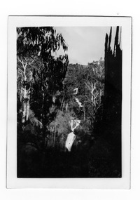
Photograph (item) - Black and white photograph, 1969
A black and white photograph of Steavenson Falls in Marysville in Victoria.A black and white photograph of Steavenson Falls in Marysville in Victoria. The Steavenson Falls is named after the Victorian Assistant Commissioner of Road and Bridges, John Steavenson who arrived in Victoria in the early 1860s.Stephen's Falls/ 1969steavenson falls, stephen's falls, waterfalls, marysville, victoria, john steavenson -
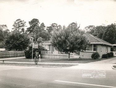 Eltham District Historical Society Inc
Photograph, A.R. Warren's house, Main Road, Eltham
Black and photograph of A.R. Warren (Fuel Merchant) house, taken from across Main Road to front of house. Present day location of Le Pine Funerals, 848 Main Road, Eltham.a.r warren, main road, eltham, houses -
 Bendigo Historical Society Inc.
Photograph - CASTLEMAINE GAS COMPANY COLLECTION: PHOTO PADDOCK, 20/07/1999
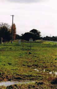
Photo of a paddock, sign ''Caution gas main'' at the centre, on the right hand side a road and on the left a fence and a power pole. Date stamp at bottom left 20/07/1999. location unknown.Kodakplace, land, paddock -
 Bendigo Historical Society Inc.
Photograph - CASTLEMAINE GAS COMPANY COLLECTION: PHOTO PEOPLE
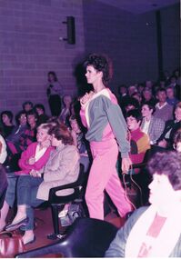
Gas and Fuel Fashion,Food,Fitness. A female model in a pink tracksuit pants and pink, grey and white top walking down the aisle of the theatre she is holding a rope. Date and location unknown.event, social, gas & fuel fashion, food, fitness -
 Bendigo Historical Society Inc.
Photograph - CASTLEMAINE GAS COMPANY COLLECTION: PHOTO PEOPLE
Gas and fuel Fashion,Food,Fitness. Photo of two blonde hair females in white tops, white and blue skirts holding plates of seafood on the right a bouquet of roses. Date and Location Unknownevent, social, gas & fuel fashion, food, fitness -
 Bendigo Historical Society Inc.
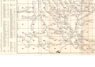
Document - RAILWAY MAP: VICTORIAN LINES 1973
Railway map - Victorian lines 1973 with list of stations and grid reference for location of stations. Inset for detail of Ballarat and Melbourne lines and stations. Shows distance from Melbourne (Spencer Street station).railways, bendigo to melbourne, stations -
 Bendigo Historical Society Inc.
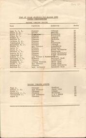
Document - BADHAM COLLECTION: VICTORIAN RAILWAYS EXAMINATION PASSES
Victorian Railways examination passes for 1932 Annual Examinations. Engine working senior showing name, position, location, marks, J Badham- Fireman with 91 marks. Foolscap paper slightly torn.document, memo, railway -
 Port Melbourne Historical & Preservation Society
Photograph - Spur line to Princes Pier, Port Melbourne, Glen Stuart, 1987
From set of nine colour photographs of various locations on the Port Melbourne Railway Line from Port Melbourne to Montague Stations, 1987: Spur line to Princes Pier from Swallow Streettransport - railways, glen stuart -
 Port Melbourne Historical & Preservation Society
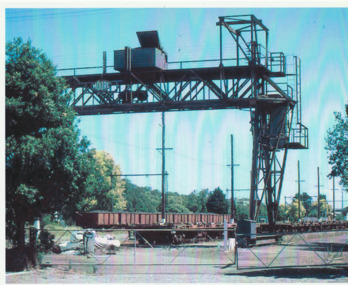
Photograph - Overhead crane in sidings on Evans Street, Port Melbourne, Glen Stuart, 1987
From set of nine colour photographs of various locations on the Port Melbourne Railway Line from Port Melbourne to Montague Stations, 1987: Enlarged view of overhead crane in the sidings at Evans Streettransport - railways, glen stuart -
 Bendigo Historical Society Inc.
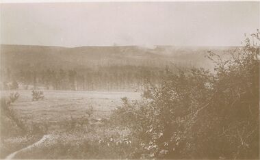
Postcard - ACC LOCK COLLECTION: SEPIA PHOTO OF AN OPEN FIELD AND FOREST, POSTCARD, 1914-1918
Postcard,WW1, sepia photo of what could have been a battle field with a forest in the background. Smoke is seen rising above the trees. Location not known. Handwritten in pencil on the back - G37 and GSpostcard, ww1, france, battlefield -
 Bendigo Historical Society Inc.
Postcard - ACC LOCK COLLECTION: SEPIA PHOTO OF A CANAL, POSTCARD, 1914-1918
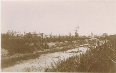
Postcard, WW1, sepia image of a canal, location not identified. Four figures walking along the left bank in front of ruined buildings. Marsh looking landscape. Handwritten in pencil on the reverse, "G44" and "GS''postcard, postcard, ww1, canal -
 Bendigo Historical Society Inc.
Postcard - ACC LOCK COLLECTION: SEPIA PHOTO OF RUINED BUILDINGS, POSTCARD, 1914-1918
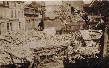
Postcard, WW1, sepia image of some ruined buildings, bricks and timber rubble. Some buildings facade at left seem relatively undamaged. Location not identified. Written in pencil on the back is G8 and GS.postcard, postcard, ww1, france, ruins -
 Bendigo Historical Society Inc.
Photograph - ACC LOCK COLLECTION: B&W PHOTO OF WW1 TRENCHES, 1914-1918
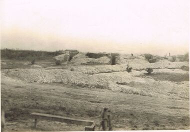
Photo, WW1, B&W image of some trenches called 'the terrace'. Location not known. A periscope (?) protruding at rear right. Handwritten in pencil on the back - M.Ds dug out on the Terraces S985 34postcard, photo, ww1, trenches, france -
 Bendigo Historical Society Inc.
Container - CLAY CRUCIBLE
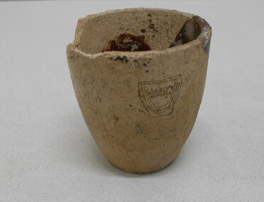
Clay gold crucible used for smelting, assaying and refining gold. Inside of crucible discoloured with brown and pale green mark. Maker's name on side: 'Juleff, number 78, (location indecipherable) England.Juleffgold mines, mining equipment, gold crucible -
Clunes Museum
Map, CHARLES FENTON, TRADERS OF FRASER STREET CLUNES
4 X SHETS OF PAPER COMMECTED WITH STICKY TAPE SHOWING SHOPS OF FRASER STREET CLUNES WITH THE NAMES OF TRADERS AT EACH SHOP LOCATION. ALTHOUGH UNDATED IT IS EXPECTED THAT THIS MAP DATES TO APPROX 1870C1870fraser street, traders of clunes