Showing 2441 items matching "orchard"
-
 Eltham District Historical Society Inc
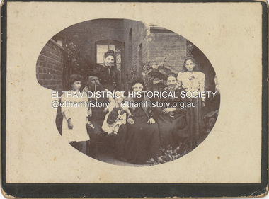
Photograph - Cabinet Photograph, William Ingram family, Birmingham, England, c.1880
William Ingram with possibly his wife Pamela Thomas and family members. William is second from left with pipe, the others unidentified. The family lived in Birmgham, England. William, a baker died in 1905. William and Pamela had six children; William George Grove (1861-1939), Elizabeth (1865), Evan Thomas (1867-1956), Joseph (1868-1934), Louis (1870-1941) and John (1872-1958). John Ingram learnt his trade from his father but following a quarrel with his father, he ran away and worked his passage to Australia as a ships baker. His elder brother Evan was already in Australia living in Malvern. It was here that he met Ada Key. John and Ada were married in Fremantle, Western Australia. They travelled to England then Cape Town, a family already started. They returned to Melbourne and in 1901 bought land at Research where he worked to establish an orchard and worked at night asa baker in Eltham. The fashion and hairstyles appear trypical of around 1880ingram family, birmingham, william ingram, baker, pam thoonen (nee ingram) collection -
 Eltham District Historical Society Inc
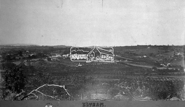
Negative - Photograph, Eltham, Vic, c.1890
View looking northeast from present day Ely Street (near intersection of present day Cronus Court and Porter Street) across what will become the site of Eltham High School towards Main Road showing the Eltham Courthouse and Police station. View is very similar to the sketch of Eltham published in 'The Illustrated Australasian News', December 26, 1884, p212. Note the large bluestone cell block behind police house and stable. George Knapman's Shoeing Forge next to the courthouse and the concentration of buildings around the Evelyn Hotel and Watson's Eltham Hotel on opposite sides of Main Road at Pitt street. Also note George Stebbing's cottage (c.1860) on Pitt Street behind the courthouse and 'Sunnyside' (home of W.J. Taylor built c.1885) at the top of the hill on Bible Street. In the foreground are orchards running up to the main street, Maria Street and also between Brougham Street and Dalton Street bordered by Bible Street.This photo forms part of a collection of photographs gathered by the Shire of Eltham for their centenary project book,"Pioneers and Painters: 100 years of the Shire of Eltham" by Alan Marshall (1971). The collection of over 500 images is held in partnership between Eltham District Historical Society and Yarra Plenty Regional Library (Eltham Library) and is now formally known as the 'The Shire of Eltham Pioneers Photograph Collection.' It is significant in being the first community sourced collection representing the places and people of the Shire's first one hundred years.Digital image 4 x 5 inch B&W Negshire of eltham pioneers photograph collection, eltham, 1890, bible street, brougham steet, dalton street, eltham courthouse, eltham hotel, evelyn hotel, franklin street, grant house, knapmans forge, main road, maria street, orchards, police residence, police station, pre 1900, stebbing cottage, sunnyside, w.b. andrew corn store, watsons hotel, little eltham -
 University of Melbourne, Burnley Campus Archives
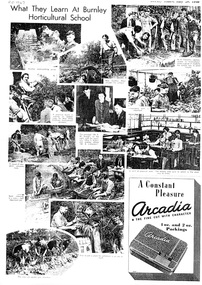
Newspaper - Newspaper Cutting, The Weekly Times, What They Learn at Burnley Horticultural School, 1940
Photocopy of a page of photographs from "The Weekly Times" July 20, 1940. A variety of activities. the weekly times, burnley horticultural college, p trevaskis, cynthia allen, hilda kirkhope, s kirby, plant potting, liliums, ploughing, pruning roses, a w jessep, e littlejohn, nursery, botany class, seed cleaning, vegetable garden, orchard -
 Eltham District Historical Society Inc
Document - Folder, Partington family
Charles Partington married Ellen Whatmough; they and their children, Robert and James, came to Australia in 1857 because Ellen's brother, Robert Whatmough, had come here in 1841. Whatmough was Melbourne's first lamplighter while also working in John Batman's Spencer Street orchard; he moved in 1842 to establish an orchard in Greensborough. Both Partington boys died soon after the family arrived at Greensborough but later two daughters were born, Prudina and Maria, and five sons, including William . On arrival Charles Partington began work for Mr Flintoff at Black Hills and was later toll keeper on what is now Watsonia Road. He was later a successful orchardist. William Partington married Annie-May Medhurst, daughter of David Medhurst and Martha Ruston, daughter of Peter Ruston who had settled in Greensborough in the 1850s after working for Mr Hooper in Darebin Creek, then moved to Panton Hill in 1866 working as a carrier. The Rustons had six children, including Martha and James. Martha married David Medhurst in 1882 who was the son of David Medhurst and Charity Jane Pink. After David's death, Charity Jane married George Wescott. David and Martha Medhurst had eight children, including Annie May. They bought land in Main Street, Greensborough and set up as a greengrocer. William and Annie-May Partington's family home, Willis Vale, purchased from Mr Meagher by William's father, Charles; it was built by Meagher in 1839 but destroyed by vandals in 1966 after being compulsory purchased for parkland now called Partington's Flat. Their children were Eva, Grace, Alan, Jessie, and Jack. They attended Greensborough Primary School. Alan married Wyn. Contents Newspaper article: "Link with the past", Diamond Valley News, 21 February 1984. Alan Partington's research on Robert Whatmough, early settler in Greensborough, and his brother-in-law Charles Partington. Newspaper article: "How early families linked up", Diamond Valley News, 28 February 1984. Alan Partington's research into the Ruston and Medhurst families. Newspaper article: "Old days recalled", Diamond Valley News, 13 March 1984. Alan Partington's research in the Partington family.Newspaper clippings, A4 photocopies, etcalan partington, robert whatmough, watmough park greensborough, robert partington, james partington, elen partington nee whatmough, road tolls watsonia road, prudina partington, maria partington, william partington, willis vale, partington's flat greensborugh, mr meagher of greensborough, apollo parkways estate, charles partington, annie-may partington nee medhurst, david medhurst, martha medhurst (nee ruston), jack medhurst, peter ruston, hooper of darebin creek, greensborough hotel, james ruston, charity jane medhurst (nee pink), main street greensborough, eva partington, grace partington, jessie partington, jack partington, orchards in plenty river area, greensborough primary school, wyn partington, flintoff of black hills -
 Mt Dandenong & District Historical Society Inc.
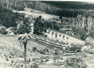
Photograph, The Valley of the Harmony Vale Settlement c1910, 1973
Scene looking across the valley of Harmony Vale from Barbers Road. c1910. Photograph copied by John Lundy-Clarke in 1973. This photograph has a detailed inscription on the back handwritten by John Lundy-Clarke in 1974.The valley of the Harmony Vale settlement on the Olinda Creek from Barbers Road. "Shiloah" on far left centre. John William Richardson's home among trees left of centre. Homestead Harmony Vale above log yard (see below) and among orchard trees. Child Bros sawmill and log yard with logs among trees above flat cultivation right of centre. Bert Childs home beyond "Harmony Vale". Lucas' "Glenrivers" is in gully above main clearing centre top left. Frank Childs home among trees centre of picture. Taken about 1910 by Rose Series. Copied 1974 JLC.kalorama, harmony vale, olinda creek, barbers road, shiloah, sawmill, child, bert child, glenrivers -
Whitehorse Historical Society Inc.
Letter - Correspondence, The Fruitgrowers and Primary Producers Defence League of Australia, 1946
To WG Payne from Reporter Pty Ltd1 4.1946To WG Payne from Reporter Pty Ltd account rendered 2 6.1946Ditto 3 4.1946To WG Payne from G Compton re inconvenience to growers in stands ôKö & ôLö 4 6.1946To WG Payne from HJ Noonan re registration of citrus growers & limit planting 5n.some activities of District Council since last year 6 4.1946To WG Payne from JM Ward re Mr GayfordÆs lecture on pest control measures 7 7.1946To WG Payne from HJ Noonan re notice of AGM 8 4.1946To WG Payne from G Handsyde re meeting concerning citrus growers organizations 9 5.1946To WG Payne from GW Gayford re a suitable date for his lecture 10 6.1946To WG Payne from G Handsyde re an official representation at meeting 11 5.1946To WG Payne from G Handsyde re lecture by Mr Gayford 12 3.1946To WG Payne from G Compton re congestion in sheds ôKö & ôLö 13 3.1946To WG Payne from W McKenzie re registration & licensing of growers 1410.1945To WG Payne from GW Gayford re DDT spray substitute for nicotine-sulphate 1510.1945To RS Ryan from FM Forde re concern of importation of apples from America 16n.d.To M&MDC;DL from W Payne re action of Inspectors condemning bushel cases 1710.1945To WG Payne from JM Ward re neglected orchards due to shortage of labour 1810.1945To MMDC F&PP Defence League from HC Pope re production of Secateurs 1910.1945To WG Payne from JM Ward re transferring of Orchard Supervisors 20 2.1945T0 WG Payne from HJ Noonan re copy of Conference report. To WG Payne from Reporter Pty Ltd clubs and associations, fruitgrowers and primary producers defence league of australia -
 Eltham District Historical Society Inc
Photograph, Liz Pidgeon, Heritage Excursion; East of Eltham, 6 Sep 2014, 20 May 2017
Newsletter No. 218, September 2014 September Excursion - East of Eltham Walk In Newsletter No. 197, March 2011, there was a brief history of Crown Allotment 15 Section 5 Parish of Nillumbik (CA 15) a parcel of land of a quarter of a square mile extending from Eucalyptus Road to Reynolds Road at the eastern extremity of Eltham. From the 1940s it was known as Stokes orchard. In later years it has been subdivided for residential purposes but leaving significant areas as power line and water supply reserves and bushland reserves that are habitat for the threatened For our excursion on 6th September we intend to walk through CA 15 to a bushland reserve east of Reynolds Road. The walk will traverse the boundary between suburban Eltham and the non-urban areas to the south and east. This is a pleasant walk through residential areas and bushland. Along the way we will discuss the early and more recent history of CA 15 as well as local natural history and geology. This walk is about 3.5 km in length and will take 2 to 2.5 hours. It will start at 2pm at the corner of Eucalyptus Road, Pitt Street and Nyora Road.Born Digitaleltham east, eltham district historical society, heritage excursion, activities, nyora road, reynolds road, gum tree road reserve, diosma road, stokes orchard, eucalyptus road -
 Eltham District Historical Society Inc
Photograph, Liz Pidgeon, Heritage Excursion; East of Eltham, 6 Sep 2014, 20 May 2017
Newsletter No. 218, September 2014 September Excursion - East of Eltham Walk In Newsletter No. 197, March 2011, there was a brief history of Crown Allotment 15 Section 5 Parish of Nillumbik (CA 15) a parcel of land of a quarter of a square mile extending from Eucalyptus Road to Reynolds Road at the eastern extremity of Eltham. From the 1940s it was known as Stokes orchard. In later years it has been subdivided for residential purposes but leaving significant areas as power line and water supply reserves and bushland reserves that are habitat for the threatened For our excursion on 6th September we intend to walk through CA 15 to a bushland reserve east of Reynolds Road. The walk will traverse the boundary between suburban Eltham and the non-urban areas to the south and east. This is a pleasant walk through residential areas and bushland. Along the way we will discuss the early and more recent history of CA 15 as well as local natural history and geology. This walk is about 3.5 km in length and will take 2 to 2.5 hours. It will start at 2pm at the corner of Eucalyptus Road, Pitt Street and Nyora Road.Born Digitaleltham east, eltham district historical society, heritage excursion, activities, nyora road, reynolds road, gum tree road reserve, diosma road, stokes orchard, eucalyptus road