Showing 11146 items matching "planning "
-
 University of Melbourne, Burnley Campus Archives
Plan - Photocopy, Plan Research Institute, 1986-1989
Donated by Emma Ferguson and Jo van Berkel for their Oct 1994 Thesis.Photocopy of site plan of the Victorian College of Agriculture and Horticulture. Scale 1:500. Overall plan of garden with main buildings and gardens named. (Also see B11.0711 and B11.0715 for the same plan.)Note on reverse, "Not from Archives."victorian college of agriculture and horticulture, research institute, emma ferguson, jo van berkel -
 Bendigo Historical Society Inc.
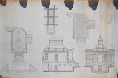
Plan - MARKS COLLECTION: PLAN OF ALTERATIONS TO FORTUNA VILLA
Copy of plan for alterations and additions to Fortuna Villa. Plan shows various elevations of Fortuna entry, plan of basement, ground floor (entry) and ceiling in entry. Signed by W. Beebe, Architect.buildings, house, fortuna villa -
 Bacchus Marsh & District Historical Society
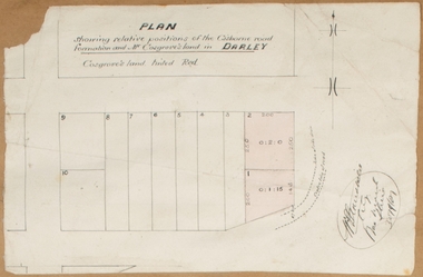
Map, Plan showing relative positions of the Gisborne road formation and Mr. Cosgrove's land in Darley. 1907
No background information about the roadworks referred to in this plan has been found. The portion of land referred to as 'Cosgroves' in this plan is located close to the present day Darley Park Recreation Park in Darley, near Bacchus Marsh. The land indicated appears to be close to the corner of Grey Street and Gisborne Road. James Cosgrove who died in 1923 aged 65 owned a farm of 52 acres in this area of Darley.Single page map showing a proposed deviation of the Gisborne road in Darley and its position relative to land owned by Mr. Cosgrove. The land owned by Cosgrove is shaded in pink. No scale indicated. Part of a set of maps which are pasted into a bound volume containing 76 maps or plans in total. High resolution digital image stored on BMDHS computer network. Signature (illegible), Eng, Bac Marsh Shire, 30/9/07bacchus marsh roads and streets, darley victoria maps -
Bendigo Historical Society Inc.
Document - MARKS COLLECTION: PLAN OF MR. DENNIS'S MINE, NEW CHUM REEF
Mine plan drawn on heavy parchment paper. On top of plan 'Plan of workings for Mr. Dennis' Mine, New Chum Reef' Names on plan : Boundary line Koch & Hildebrandt; boundary line Bonati & Co. Signed on bottom (signature not clear) 14/9/72. -
 Bendigo Military Museum
Plan - MAP, TOURIST, L Joly, A Maunier, WWI
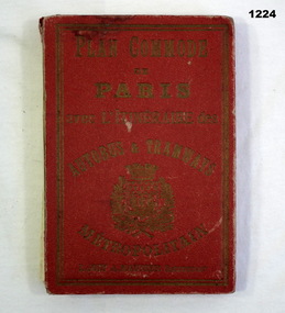
The map belonged to Jack Grinton No 1043 38th Batt AIF. At Wars end extensive leave was granted, Jack journeyed to Paris, Nice, Monte Carlo taking many photos. Part of the Grinton collection which included hundreds of negatives and developed photos that he took during the War. Refer Cat No 1280 for service details. Refer 1317P, 1320P.Map of Paris. Red cardboard or paper hardcover, new edition guide of metropolitan Paris (ministries, tramways, monuments), Index in front, folded paper map attached to back cover. "Plan commode de Paris avec l'itineraire des autobus & tramways metropolitan"documents-maps, french -
 Victorian Aboriginal Corporation for Languages
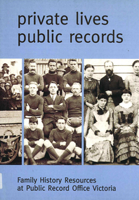
Book, Private lives, public records : family history resources at Public Record Office Victoria, 2003
Intended as a key resource for both first-time and experienced genealogists. It offers an introduction to the role, services and collection of Public Record Office Victoria, and a guide for family history researchers using the archives.colour photographs, b&w photographs, charts, letters, records, maps, plansgenealogy, local history, family history, public records, bibliographies, catalogues, victorian history -
 Robin Boyd Foundation
Slide, Robin Boyd, 1950
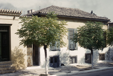
Penleigh Boyd, Robin and Patricia Boyd's son, writes “Prior to 1950 Robin, like most other amateur or hobby photographers, took black and white printed photographs. The oldest slides date from 1950 when Robin and Patricia travelled to Europe on Robin’s Robert Haddon Travelling Scholarship.” In 1948 Robin Boyd was awarded ‘joint first place’ in the Robert Haddon competition for his design of Mildura art gallery. The scholarship helped fund their first overseas trip. Robin and Patricia were passengers on the Greek ship “Cyrenia” departing in May 1950, passing through the Suez Canal and landing in Genoa five weeks later. For six months, they travelled extensively throughout Europe (predominantly driving themselves) - France, Italy, United Kingdom, Sweden, Denmark, Germany, Austria, Switzerland and Spain.Colour slide in a mount. Two-storey house in Piraeus, GreeceGreece / House / House in Pyraeus, 2-Storey Living Plan (All Handwritten)haddon travelling scholarship, haddon, robin boyd, slide -
 University of Melbourne, Burnley Campus Archives
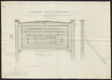
Plan, Proposed Sign for Entrance to Burnley, 1931
(1) Correspondence between Mr Zevan (Government Cool Stores), the Agricultural Superintendent, R. Crowe (Exports Superintendent) and A.W. Jessep re design for new entrance gates at Burnley Gardens, between 31.03.1931 and 09.07.1931. Invoice from signwriter (A. Clegg). (2) Pencil sketch of proposed design with annotations. (3) Coloured drawing to scale.On verso of drawing: "Gate sign & Watering plans" and "File State Public Works"a.w. jessep, burnley gardens, f. zeven, signs, victoria. department of agriculture -
 Old Castlemaine Schoolboys Association Inc.
Poster, Plan now to come back to Castlemaine in 1967
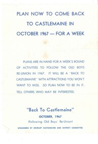
Plan now to come back to Castlemaine in October 1967 - for a week plans are in hand for a week's round of activities to follow the old boys reunion in 1967. It will be a back to Castlemaine with attractions you won't want to miss. So plan now to be in it. Tell others who may be interested. Sponsored by developed Castlemaine and district committee -
 Kew Historical Society Inc
Plan - Subdivision Plan, Boulevard Estate - Boulevard Section, 1930-1936
Pru Sanderson, in her groundbreaking ‘City of Kew Urban Conservation Study : Volume 2 - Development History’ (1988), summarised the periods of urban development and subdivisions of land in Kew. The periods that she identified included 1845-1880, 1880-1893, 1893-1921, 1921-1933, 1933-1943, and Post-War Development. These periods were selected as they represented periods of rapid growth or decline in urban development. An obvious starting point for Sanderson’s groupings involved population growth and the associated economic cycles. These cycles also highlighted urban expansion onto land that was predominantly rural, although in other cases it represented the decline and breakup of large estates. A number of the plans in the Kew Historical Society’s collection can also be found in other collections, such as those of the State Library of Victoria and the Boroondara Library Service. A number are however unique to the collection.The Kew Historical Society collection includes almost 100 subdivision plans pertaining to suburbs of the City of Melbourne. Most of these are of Kew, Kew East or Studley Park, although a smaller number are plans of Camberwell, Deepdene, Balwyn and Hawthorn. It is believed that the majority of the plans were gifted to the Society by persons connected with the real estate firm - J. R. Mathers and McMillan, 136 Cotham Road, Kew. The Plans in the collection are rarely in pristine form, being working plans on which the agent would write notes and record lots sold and the prices of these. The subdivision plans are historically significant examples of the growth of urban Melbourne from the beginning of the 20th Century up until the 1980s. A number of the plans are double-sided and often include a photograph on the reverse. This plan shows a subdivision with two sections: the ‘Boulevard Section’ and the ‘Riverside Section’. The first of these sections bordered Burke Road between Kilby Road and the farm beside the Yarra. Kilby Road, Munro Road, Burke Road and Old Burke Road bordered the 102 lots in the Boulevard Section of the plan. The streets within the Section included Walbundry Avenue, Inverness Way, Riverside Avenue, Cascade Street and Kyora Parade. These street names, at least in this subdivision plan linked the two Sections of the subdivision. At a later date, the City of Kew decided to alter the street names. Walbundry, Inverness, Riverside, Cascade and Kyora were all renamed as ‘Drives’ (e.g. Kyora Drive). The subdivision plan is of interest in that it names High Street in Kew as Doncaster Road. It also shows the location of the wooden church that was later removed to Yarraville on the corner of Kilby Road and High Street. The plan predates later developments such as the S. E. Dickens Supermarket.subdivision plans - east kew, boulevard estate, munro road -- kew east (vic.), kilby road -- kew east (vic.), burke road -- kew east (vic.), walbundry avenue -- kew east (vic.), inverness way -- kew east (vic.), riverside avenue -- kew east (vic.), cascade drive -- kew east (vic.), nyora parade -- kew east (vic.) -
 Whitehorse Historical Society Inc.
Document - Various including maps, titles, posters, Land ownership of 4 Austin Street, Mitcham, 1873 - 2019
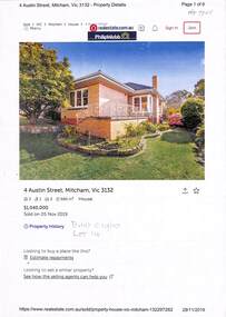
Ownership history of 4 Austin Street, Mitcham.Ownership history of 4 Austin Street, Mitcham between 1873 to 2019, including the plan of the Mellorton Estate, Mitcham (1923), showing some lots priced at one hundred and forty-five pounds and the Charlesworth Estate ((1913). The Austin Street house was purchased by Martin and Shirley Gleeson 1956 and sold in 2019. Subdivision map of area south of Burnett Street to Harrison Street. non-fictionOwnership history of 4 Austin Street, Mitcham.drake real estate, charlesworth estate mitcham, mellorton estate mitcham, austin street mitcham no4, ainger frank -
 Bendigo Historical Society Inc.
Magazine - Magazines and brochures
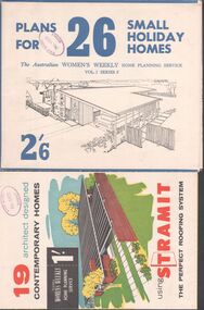
BHS Collection.Eight magazines and brochures. Titles are: Australian House and Garden book of Small Home plans, Best Homes, New horizons in houses, 19 Architect designed contemporary homes, 22 specially selected home plans, Plans for 26 small holiday homes, The Australian Women's weekly's home planning service 28 home plans and an advertising brochure for Daniel Robertson.Phillip Ellison name on several books, and the stamp of the State School No. 1008 Axedale on four others.homes, building -
 Melbourne Tram Museum
Document - Photocopy, "MMTB Proposals for General Scheme, c1970
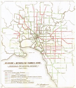
... Planning ...Colour photocopy of a MMTB drawing titled "MMTB Proposals for General Scheme showing a detail plan of tramways proposed for Melbourne 1923. Signed by J. Strickland 27-8-1923. Shows cable trams, existing tramways, authorised tramways, proposed, VR tramways, rail lines and waterways. Not known when colour copy actually made - could have been an AETA or a TMSV reproduction. See Reg Item 2089 for an original of this document.trams, tramways, mmtb, melbourne, cable trams, electric trains, tramways, proposals, planning -
 Federation University Historical Collection
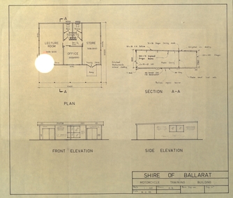
Plan, Shire of Ballarat Motorcycle Training Building, 1983, 24/03/1983
Plan for the Shire of Ballarat Motorcycle Training Building shoing ground plan, Section A-A, Front Elevation and Side Elevation. shire of ballarat, motorcycle, motor bike -
 Federation University Historical Collection
Plan - Plans, Plan of the Ballarat Gaol
Copies of plans of Ballarat Gaol. One has later Ballarat School of Mines buildings drawn onto a plan. ballarat gaol, ballarat school of mines library, e.j. tippett library, learning resource centre, ballarat supreme court, governor's residence, domestic arts, dressmaking -
Port Melbourne Historical & Preservation Society
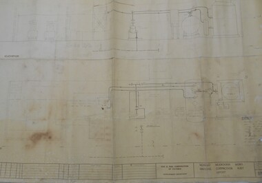
Plan - Port Melbourne Yacht Club reconstruction, Taylor Howden Pty Ltd, Architects, c. 1990
Clubhouse burned 14 February 1990 and was rebuilt with volunteer labour over many years (opened 1998)Plan of Port Melbourne Yacht Club clubhouse reconstruction 1990 Plan of rebuilt clubhouse; faded almost to illegibilitybuilt environment - recreational facilities, societies clubs unions and other organisations, port melbourne yacht club, pmyc, taylor howden pty ltd -
Port Melbourne Historical & Preservation Society
Plan - Port Melbourne Yacht Club reconstruction, Taylor Howden Pty Ltd, Architects, c. 1990
Clubhouse burned 14 February 1990 and was rebuilt with volunteer labour over many years (opened 1998)Plan of Port Melbourne Yacht Club clubhouse reconstruction 1990 - Preliminary sketch plans; faded almost to illegibilitybuilt environment - recreational facilities, societies clubs unions and other organisations, port melbourne yacht club, pmyc, taylor howden pty ltd -
Whitehorse Historical Society Inc.
Pamphlet, Keeping Blackburn Beautiful, 1984
Keeping Blackburn Beautiful, a planning scheme for Blackburn, a circular for residents soliciting comments for Advisory Committee, on a planning scheme.Keeping Blackburn Beautiful, a planning scheme for Blackburn, a circular for residents soliciting comments for Advisory Committee, on a planning scheme.Keeping Blackburn Beautiful, a planning scheme for Blackburn, a circular for residents soliciting comments for Advisory Committee, on a planning scheme.blackburn, advisory committee -
University of Melbourne, Burnley Campus Archives
Work on paper (item) - Student Work, Shane Furlong, Kneebone Habitat Landscape Design, 4th December, 2014
Created as an assignment for HORT90035, 'Landscape Construction and Graphics,' a subject at Burnley Horticultural College coordinated by Andrew Laidlaw. assignment, landscaping, burnley, 'landscape construction and graphics', hort90035, andrew laidlaw -
 Bendigo Historical Society Inc.
Map - BENDIGO WEEROONA GASWORKS MAP/PLAN COLLECTION: COMPRESSOR PLAN LAYOUT, 15.2.1971
Plan showing compressor plan layout at Bendigo Weeroona Gasworks. Prepared by Gas and Fuel Corporation Development Department.plan, bendigo, bendigo weeroona gas works, gasworks, public utility, gas and fuel corporation -
 Melbourne Tram Museum
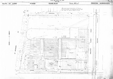
Drawing, Melbourne & Metropolitan Tramways Board (MMTB), "Preston Workshops", c1938
Set of nine photocopied plans or drawings on A3 sheets of the "Preston Workshops" - c1939 .1 - P8491 - Plan of land showing layout and associated drawings including Reservoir railway line - 19-4-1939. .2 - P8492 - Plan of Timber stacks and Hall - 3-2-1939 .3 - P8493 - Plan of Offices and location of sub-station - 13-12-1938 .4 - P8494 - Plan of Store including Oil store - c1939. .5 - P8495 - Plan of Paint Shop and relationship to timber stack - 1-3-1939 .6 - P8496 - Plan of Car building and Repairs shop - 6-12-1938 .7 - P8497 - Plan of machine shop - 10-12-1938 .8 - P8500 - Plan of Blacksmiths shop - 1-12-1938 .9 - P8590 - Plan of Substation - 1-12-1938trams, tramways, drawings, depots, property, preston workshops, workshops, substation -
Kew Historical Society Inc
Plan - Burke Road Junction Estate, East Kew, 1940
Subdivision plans and real estate flyers/brochures reveal a number of aspects of urban development and history. The Kew Historical Society's collection of these plans, as well as advertisements extracted from magazines, cover key aspects of community development and architectural history of Kew and Kew Eat as well as surrounding suburbs. While most of the plans in the collection were gifted to the Society by the former City of Kew, a number of other plans and advertisements have been donated by individuals, of which this is an example.Original 4-page bifold brochure advertising the Burke Road Junction Estate in Kew East. Advertised for sale in 1940, the estate comprised 16 'Central Allotments' fronting High Street, Kilby Road, and Glass Street. Pages 1 & 4, the front and back covers, includes a panoramic photograph of the junction which features a number of shops still extant, but also with buildings long demolished and redeveloped. These include the petrol station and the dairy on the southeast and southwest corners of Burke Road and High Street/Doncaster Road. The dairy includes a statue of a cow on its roof. Pages 2 & 3 include a detailed plan of the estate. subdivisions -- kew east (vic.), burke road junction estate -
Whitehorse Historical Society Inc.
Article, City's Chief Executive Officer goes into retreat, 31/08/1988 12:00:00 AM
After five years as the City's Chief Executive Officer, Les Fell is to retire.After five years as the City's Chief Executive Officer, Les Fell is to retire. He looks back on his term with satisfaction, including his representation of Australia on the International City Management Association. He and his wife plan to run a seminar centre and executive retreat in Campaspe House, Woodend.After five years as the City's Chief Executive Officer, Les Fell is to retire. fell, les, fell, shirley, city of nunawading, local government -
 Federation University Historical Collection
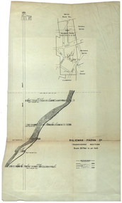
Plan, Sulieman Pasha Co Plan Transverse Section
The Sulieman Pasha is possibly named after the most important Sultan of the Ottoman Empire, Suleiman One, or Suleiman the Magnificent, when the Ottoman Empire was at its peak. Or potentially a number of Ottoman governors, statesmen and military commanders with the same name after, however the spelling is slightly different to the mine name. No Turkish connection was found relating to the formation of the company, and remains unconfirmed. The mine operated from two shafts; No. 1 near the corner of Humffray and Mair streets, and also near where the Welcome Nugget (2217 ounces) was found years earlier; and the controversial No. 2 shaft several blocks south bordering the northern side of the main highway through Ballarat. The company produced 62 666 ounces of gold, the twelfth highest quartz reef gold production for any mine on the Ballarat goldfield. Some crushing figure examples are January-June 1881: 3674 tonnes 1085 ounces; January-June 1885: 2949 tonnes 1281 ounces; July-December 1885: 4459 tonnes 1119 ounces; January-June 1887: 1869 tonnes 730 ounces; July-December 1892: 1450 tonnes 771 ounces; July-December 1896: 4365 tonnes 1372 ounces. Like many mines in the area, gold grades were low. John Watson was noted as mine manager in the 1880s, and John Williams 1890s. The company was re-organised twice increasing the number of shares from 4000 to 24 000, and increasing the capital available. The Sulieman Pasha Company was formed in 1878. David Fitzpatrick was given the honour of turning the first sod of both the No.1 and later No. 2 shafts. The first dividend was given to shareholders in July 1881. The company obtained a prospecting vote (government grant) to start, and was very proud to be the first Victorian gold mining company to pay the funds back to the government. The event was marked by a lavish banquet laid out for ministers and government officials by the company. Leases were purchased to the south in 1885 to the Llanberris Mine boundary, after poor results began accumulating from the small No. 1 shaft. To take advantage of this new land the company planned to sink a second shaft. Initially this was to take place on government land, but the uproar from nearby residents caused the company to purchase land along the Main Road (now Western Highway), and the old Yarrowee Hotel which had occupied the site since the alluvial digger days of the 1850's was demolished. The area had since those days become heavily occupied with a number of shops, houses, a post office, church and two schools in the immediate area. The thought of an underground mine next door drew considerable opposition. The company (before the days of public relations departments) wrote 'most people would have thought that progress as vital as mining would be supported by tradesmen whose business rely on the mining industry. It seems when it comes to mining they are bereft of their senses, and considering the low ebb of mining in Ballarat East, the action of our opponents are unaccountable. (Sarcastically) There are certain engineering difficulties in moving the quartz reefs to a new location, but if we could to appease our opponents we would'. The company also wanted to take over 4 acres of the St Paul's school oval for machinery, but accused the St Paul's Church of wanting extortionate amounts of money upfront, and on a yearly basis for the privilege. It stated the church could not be opposed to mining when several years earlier it had formed its own company to mine the land, only for shareholders to lose their money. In 1886, the company approached the Minister for Mines, and attended heated public meetings on the matter. The local residents, shop owners, and church submitted a 60 person petition to the local council and government authorities. They stated the shaft contravened the mining statutes, which stating no mining could take place within 150 yards of a public building or church. A speech by a resident stated 'mining always comes with glorious pictures of the great benefits which would accrue all parties concerned if their request is granted, but if property is destroyed or depreciated in value, no-one then comes forward and compensates them'. The No. 2 shaft was approved including taking over part of the school oval. In 1888, workers at the company's No. 2 shaft went on strike to try and bring their wages in line with other mines in the district (the No. 1 shaft was operated by tributers). William Madden (26) was killed from a fall of earth underground the same year, while a year later his father John Madden (70) was similarly killed in the Madame Berry Mine elsewhere in the district. In 1897 as the amount of gold being found fell away, it came to light part of the deal to purchase the Yarrowee Hotel site was a 5% royalty on gold found. Shareholders could not understand why they were paying a royalty to the former owners of the property. The mine closed in 1898 due to a lack of gold. In 1902 a boy (age unknown) called Charles Lee was killed from a fractured skull while working to dismantle the Sulieman Pasha plant. The fuss over the No. 2 shaft had a sequel. On the company winding up, the land was purchased by J.S. Trethowan who built a house next to the shaft. In 1907, the shaft caved-in creating a sinkhole immediately at the back of the house. A Mr Chamberlain heard a deep rumbling sound at 5am, and looked out the window to see his fowl house and thirteen chickens disappear down an expanding hole. He then went back to bed, and called the police later in the day. The shaft was 1050 feet deep, and the hole at the surface that developed was 20 feet by 17 feet across, and 20 feet depth. In 1930 it is reported a syndicate had been formed to clean out the old shaft, and re-open the mine. It is assumed this was the No. 1 shaft but no more was found. (https://www.mindat.org/loc-304239.html, accessed 07/08/2019) A transverse section plan of the Sulieman Pasha Mine.sulieman pasha company, plan, mining, united black hill mine, victoria united mine, victoria street, britannia united mine, last chance mine, llanberris mine, ottoman empire, john watson, john williams, david fitzpatrick -
Ringwood and District Historical Society
Documents, 1997 Bushland Management Plans for BJ Hubbard Reserve, Wombolano Park, Loughie's Bushland, and weed control monitoring sheet
Five Bushland Management Documents 1. Bushland Reserve Management Plan 2. Weed Control Monitoring Sheet 3. BJ Hubbard Reserve - Bushland Management Plan 1997 4. Wombolano Park - Bushland Management Plan 1997 5. Loughie's Bushland Management Plan 1997 -
 Bendigo Historical Society Inc.
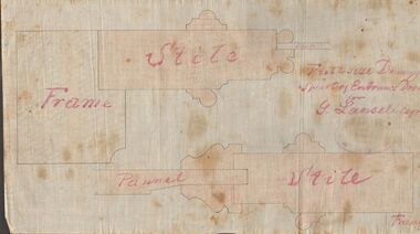
Document - MARKS COLLECTION: DRAWING ENTRANCE DOOR FOR G. LANSELL
Plan drawn on waxed paper. Written on plan 'Full size Drawing of part of entrance door for G. Lansell, Esq' Plan shows line drawings of side elevations of Frame, Stile, Pelmet, Stile, Frame. On bottom of plan purple ink stamp 'Vahland & Getzschmann, Architects, Sandhurst'.Vahland & Getzschmann, Architects, Sandhurst.bendigo, house, fortuna villa -
 Melbourne Tram Museum
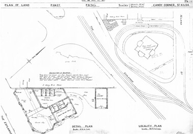
Drawing, Melbourne & Metropolitan Tramways Board (MMTB), "Candy Corner St Kilda", c1938
Set of two photocopied plans or drawings on A3 sheets of "Candy Corner St Kilda" .1 - P8427 - Plan showing locality plan, detail plan and adjacent buildings - 6-12-1938 .2 - ditto, but not the detail of the building in the centre of the island - "Green Knoll" Cafe and Amusement Park.trams, tramways, drawings, depots, property, candy corner, st kilda, turning loops -
 Melbourne Tram Museum
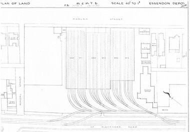
Drawing, Melbourne & Metropolitan Tramways Board (MMTB), "Essendon Depot", c1937
Set of three photocopied plans or drawings on A3 sheet of Essendon Depot - c1937 to 1944 .1 - P? - Plan showing depot block and building plan with adjacent private houses and properties - dated 30-12-1944 .2 - P8008 - Plan showing depot block and building plan with adjacent private houses and properties - dated 27-4-1937 .3 - P8089 - Detail plan of depot and offices, dated 27-4-1937 - prior to new offices being built.trams, tramways, drawings, depots, property, essendon depot -
 Melbourne Tram Museum
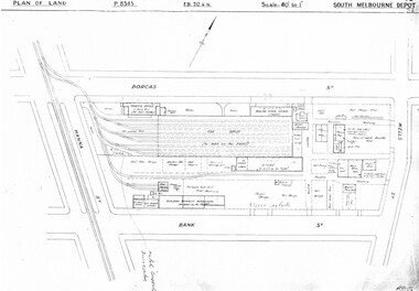
Drawing, Melbourne & Metropolitan Tramways Board (MMTB), "South Melbourne Depot", c1937
Set of five photocopied plans or drawings on A3 sheet of "South Melbourne Depot" - c 1937 .1 - P8345 - Plan of land showing MMTB land and surrounding properties. .2 - P8346 - Plan of land showing detail of offices .3 - P8347 - Plan showing detail of tram shed and adjacent buildings .4 - P8348 - Plan showing detail of buildings along the side of the block. .5 - P8349 - Plan showing details of the per way yard and associated facilities.trams, tramways, drawings, depots, property, south melbourne depot -
Federation University Historical Collection
Photograph, Technical Drawings, 07/11/1990
Examning plans for library revdelopmentbryan miller, shirley falkinder, john thomas, john sharpham