Showing 25597 items matching "plenty-township-estate"
-
 Greensborough Historical Society
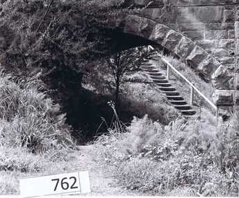
Photograph Collection, Richard Pinn, Plenty River 1979, by Alan Pinn, 1979_
Photographs of the Plenty River Greensborough. One shows Richard Pinn walking his dog (Jah) on track by river, the second photo is a close up of the Greensborough Bluestone Bridge and steps to river. The bridge has since been demolished and the path replaced by a concrete bike/walking path.Shows the river pathways and bluestone bridge in the 1979.2 b&w photographs.plenty river, greensborough, richard pinn -
 Eltham District Historical Society Inc
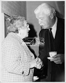
Photograph, His Excellency Sir Rohan Delacombe with a member during his visit to Lower Plenty Elderly Citizens' Club, 19 September 1973
The State Governor Sir Rohan Delacombe and Lady Delacombe visited the Shire of Eltham where they were entertained to a civic luncheon by the Shire President Cr. L. E. Clarke and councilors at the Panton Hill hotel and made a tour of the shire, including the Lower Plenty Elderly Citizens Centre.This photo forms part of a collection of photographs gathered by the Shire of Eltham for their centenary project book, "Pioneers and Painters: 100 years of the Shire of Eltham" by Alan Marshall (1971). The collection of over 500 images is held in partnership between Eltham District Historical Society and Yarra Plenty Regional Library (Eltham Library) and is now formally known as 'The Shire of Eltham Pioneers Photograph Collection.' It is significant in being the first community sourced collection representing the places and people of the Shire's first one hundred years.Digital imagesepp, shire of eltham pioneers photograph collection, eltham, governor of victoria, sir rohan delacombe, lower plenty elderly citizens' club, seniors, older women -
 Ringwood and District Historical Society
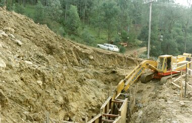
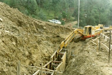
Photograph, Kubis Estate, North Ringwood on 16 June 1978, using the Kato as a crne to de-water final trench
E550 N9 Part of a 51-photo record of the development of the "Kubis" Estate, Ringwood North, including road works to Debbie Place, Kubis Drive, Werac Drive, Manuelo Drive, Iluka Place and Glenvale Road. From the Jack Lundy Clarke collection. -
 Ringwood and District Historical Society
Photograph, Kubis Estate, North Ringwood on 10 June 1978. Temporary end of Kubis Drive at junction with Debbie Place. The car stands at junction with Pamela Place
E550 N8 Part of a 51-photo record of the development of the "Kubis" Estate, Ringwood North, including road works to Debbie Place, Kubis Drive, Werac Drive, Manuelo Drive, Iluka Place and Glenvale Road. From the Jack Lundy Clarke collection. -
 Ringwood and District Historical Society
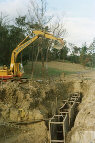
Photograph, Kubis Estate, North Ringwood on 16 June 1978. The Kato lifts a bucket out of the trench
E550 N11 Part of a 51-photo record of the development of the "Kubis" Estate, Ringwood North, including road works to Debbie Place, Kubis Drive, Werac Drive, Manuelo Drive, Iluka Place and Glenvale Road. From the Jack Lundy Clarke collection. -
 Ringwood and District Historical Society
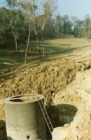
Photograph, Kubis Estate, North Ringwood on 16 June 1978. The concrete wall 27 feet deep at the pumping station in Glenvale Road
E550 N12 Part of a 51-photo record of the development of the "Kubis" Estate, Ringwood North, including road works to Debbie Place, Kubis Drive, Werac Drive, Manuelo Drive, Iluka Place and Glenvale Road. From the Jack Lundy Clarke collection. -
 Ringwood and District Historical Society
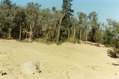
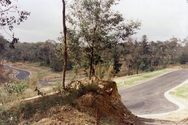
Photograph, Kubis Estate, North Ringwood in February 1978. The site of Loughnan's Lake seen from the north end of the wall. The rope tree was on the hillside on the left
E546 N2 Part of a 51-photo record of the development of the "Kubis" Estate, Ringwood North, including road works to Debbie Place, Kubis Drive, Werac Drive, Manuelo Drive, Iluka Place and Glenvale Road. From the Jack Lundy Clarke collection. -
 Ringwood and District Historical Society
Photograph, Kubis Estate, North Ringwood on 16 June 1978. Kato working on final trench. The hole for the 27 feet deep well is seen beyond the trench
E550 N10 Part of a 51-photo record of the development of the "Kubis" Estate, Ringwood North, including road works to Debbie Place, Kubis Drive, Werac Drive, Manuelo Drive, Iluka Place and Glenvale Road. From the Jack Lundy Clarke collection. -
 Ringwood and District Historical Society
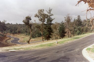
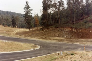
Photograph, Kubis Estate, North Ringwood in April 1978. View east up Kubis Drive from Jenkin Close past the foot of Werac Drive
E549 N16 Part of a 51-photo record of the development of the "Kubis" Estate, Ringwood North, including road works to Debbie Place, Kubis Drive, Werac Drive, Manuelo Drive, Iluka Place and Glenvale Road. From the Jack Lundy Clarke collection. -
 Ringwood and District Historical Society
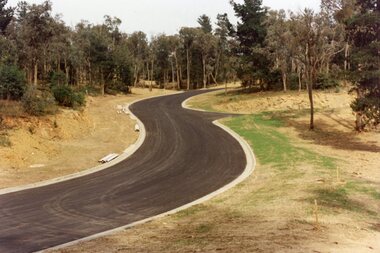
Photograph, Kubis Estate, North Ringwood in April 1978. View east up Kubis Drive over Jenkin Close and intersection with Werac Drive
E549 N18 Part of a 51-photo record of the development of the "Kubis" Estate, Ringwood North, including road works to Debbie Place, Kubis Drive, Werac Drive, Manuelo Drive, Iluka Place and Glenvale Road. From the Jack Lundy Clarke collection. -
 Ringwood and District Historical Society
Photograph, Kubis Estate, North Ringwood in April 1978. Looking west across Kubis and Werac Drives over the full length of Loughnan's Lake site. Main pool was behind the lone pine
E548 N29 Part of a 51-photo record of the development of the "Kubis" Estate, Ringwood North, including road works to Debbie Place, Kubis Drive, Werac Drive, Manuelo Drive, Iluka Place and Glenvale Road. From the Jack Lundy Clarke collection. -
 Ringwood and District Historical Society
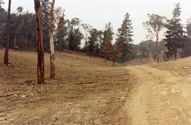
Photograph, Kubis Estate, North Ringwood in April 1978. Looking up the hill in Kubis Drive from the site of headwaters of Loughnan's Lake. Jenkins Close takes off to the right from centre
E548 N31 Part of a 51-photo record of the development of the "Kubis" Estate, Ringwood North, including road works to Debbie Place, Kubis Drive, Werac Drive, Manuelo Drive, Iluka Place and Glenvale Road. From the Jack Lundy Clarke collection. -
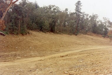
 Ringwood and District Historical Society
Photograph, Kubis Estate, North Ringwood in April 1978. Looking upstream from below the retaining wall of Loughnan's Lake that was where the truck tracks disappear. The wall was extended to the left across what was then a small gorge
E548 N19 Part of a 51-photo record of the development of the "Kubis" Estate, Ringwood North, including road works to Debbie Place, Kubis Drive, Werac Drive, Manuelo Drive, Iluka Place and Glenvale Road. From the Jack Lundy Clarke collection. -
 Ringwood and District Historical Society
Photograph, Kubis Estate, North Ringwood in April 1978. Looking west over site of Loughnan's Lake. The rope tree was on the slope to the right beyond the ridge with the lone pine
E548 N15 Part of a 51-photo record of the development of the "Kubis" Estate, Ringwood North, including road works to Debbie Place, Kubis Drive, Werac Drive, Manuelo Drive, Iluka Place and Glenvale Road. From the Jack Lundy Clarke collection. -
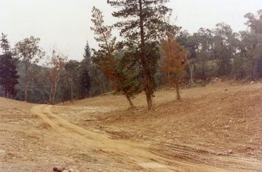
 Ringwood and District Historical Society
Photograph, "Kubis Estate", North Ringwood, in April 1978. Looking north-east over Loughnan's Lake greatest width. The rope tree was on the slope in the centre. The spillway was on the near left of the image
E548 N17 Part of a 51-photo record of the development of the "Kubis" Estate, Ringwood North, including road works to Debbie Place, Kubis Drive, Werac Drive, Manuelo Drive, Iluka Place and Glenvale Road. From the Jack Lundy Clarke collection. -
 Ringwood and District Historical Society
Legal record - Conditions of Sale (C.E. Carter), Ringwood Electric Railway Estate, Lots 98 and 99, Sale to Tilbury and Albon, 1925
Original Particulars and Conditions of Sale document by C.E. Carter & F. H. Patterson & Co, to B.C. Tilbury Esq and A.J.Albon Esq: Lots 98 and 99, Electric Railway estate, Ringwood Plan of Subdivision 9473, Crown Portion 18, Parish of Ringwood. -
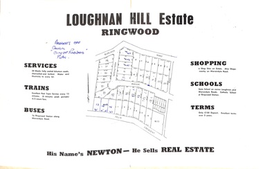 Ringwood and District Historical Society
Document - Folder, Subdivision Map - Loughnan Hill Estate, Ringwood, Victoria - circa 1960
Open centre page of land sale brochure glued to manilla folder. Map of residential and shop sites in Burlock Road (later Burlock Avenue), Adolphson Avenue and Felix Crescent, Ringwood, with summary of estate facilities and local services. Agent - T.G. Newton.(Page glued to manilla folder prevents access to front page for further sale information) -
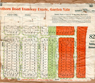 City of Moorabbin Historical Society (Operating the Box Cottage Museum)
Flyer - Hawthorn Road Tramway Estate, Garden Vale, 1920
At the end of World War One, there was a renewed interest in residential land and a number of estates opened up in the Municipality of Moorabbin.Example of the progress of the Municipality of MoorabbinAdvertising flyer for auction of real estate sales - plan of building blocks for saleHawthorn Road Tramway Estate, Auction 6 March 1920, 82 building allotmentshawthorn road, jupiter street, raynes street, saturn street, ludbrook avenue, wawn street, lucas street, garden vale, real estate, acution, moorabbin -
 Greensborough Historical Society
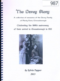
Book, The Davey Story; a collection of memories of the Davey Family of Plenty Farm, Greensborough; by Sylvia Tupper 2013, 1913-2013
This history of the Davey Family of Plenty Farm Greensborough was published to celebrate the 100th anniversary of John Henry Davey, his wife Elizabeth and children settling in Greensborough in 1913. The book contains stories written by many family members, photographs and traces the family line back to England in the 17th century.A thoroughly researched and referenced family history.108 pages, colour and black and white illustrations. Spiral binding. davey family, sylvia tupper, plenty farm, greensborough -
 Eltham District Historical Society Inc
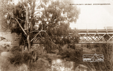
Photograph postcard, River Plenty Bridge, Greensborough
Postcard with view of bluestone bridge over the Plenty River on what is now Main Street, Greensborough. Built in 1860 by a Scottish stonemason, James Neave McKenzie. Most of the bridge was demolished in 1966 with the remaining bluestone arch preserved till 1983 when it was also demolished. This view about 1900.Digital file only Postcards scanned from the collection of Michael Aitken on loan to EDHS, 13 Feb 2018michael aitken collection, postcards, greensborough, plenty river bridge, plenty river -
 Kew Historical Society Inc
Plan - Subdivision Plan, 10 Fine Villa Sites: Ermington Estate, Kew Heights, ca. 1917
Pru Sanderson, in her groundbreaking ‘City of Kew Urban Conservation Study : Volume 2 - Development History’ (1988), summarised the periods of urban development and subdivisions of land in Kew. The periods that she identified included 1845-1880, 1880-1893, 1893-1921, 1921-1933, 1933-1943, and Post-War Development. These periods were selected as they represented periods of rapid growth or decline in urban development. An obvious starting point for Sanderson’s groupings involved population growth and the associated economic cycles. These cycles also highlighted urban expansion onto land that was predominantly rural, although in other cases it represented the decline and breakup of large estates. A number of the plans in the Kew Historical Society’s collection can also be found in other collections, such as those of the State Library of Victoria and the Boroondara Library Service. A number are however unique to the collection.The Kew Historical Society collection includes almost 100 subdivision plans pertaining to suburbs of the City of Melbourne. Most of these are of Kew, Kew East or Studley Park, although a smaller number are plans of Camberwell, Deepdene, Balwyn and Hawthorn. It is believed that the majority of the plans were gifted to the Society by persons connected with the real estate firm - J. R. Mathers and McMillan, 136 Cotham Road, Kew. The Plans in the collection are rarely in pristine form, being working plans on which the agent would write notes and record lots sold and the prices of these. The subdivision plans are historically significant examples of the growth of urban Melbourne from the beginning of the 20th Century up until the 1980s. A number of the plans are double-sided and often include a photograph on the reverse. A number of the latter are by noted photographers such as J.E. Barnes.In November 1917, the Ermington Estate was advertised as an ‘Executor’s Sale’. It included the 10-roomed villa residence, ‘Ermington’, home of the late Mrs. Lorimer, and 10 ‘magnificent allotments’. The plan in the Kew Historical Society Collection is a little more specific. Ermington is described as having 9 Rooms &c. and there are 11 lots shown on the west side of Hillcrest Avenue. In the plan, the latter is named as ‘Hill Crest Avenue’. The plan indicates that the subdivision was based on the surveying work of Johnson & Tait. Opposite Ermington, the existing house ‘Parkhill’ is identified. A faded stamp on two parts of the plan indicates that it was in the possession of Jas. [R.] Mathers, Financial Agent, [136] Cotham Road, Kew.subdivision plans - kew, ermington heights estate - kew heights -
 Kew Historical Society Inc
Plan - Subdivision Plan, Jas R Mathers Son & McMillan, East Kew Tramway Estate, 1915
Pru Sanderson, in her groundbreaking ‘City of Kew Urban Conservation Study : Volume 2 - Development History’ (1988), summarised the periods of urban development and subdivisions of land in Kew. The periods that she identified included 1845-1880, 1880-1893, 1893-1921, 1921-1933, 1933-1943, and Post-War Development. These periods were selected as they represented periods of rapid growth or decline in urban development. An obvious starting point for Sanderson’s groupings involved population growth and the associated economic cycles. These cycles also highlighted urban expansion onto land that was predominantly rural, although in other cases it represented the decline and breakup of large estates. A number of the plans in the Kew Historical Society’s collection can also be found in other collections, such as those of the State Library of Victoria and the Boroondara Library Service. A number are however unique to the collection.The Kew Historical Society collection includes almost 100 subdivision plans pertaining to suburbs of the City of Melbourne. Most of these are of Kew, Kew East or Studley Park, although a smaller number are plans of Camberwell, Deepdene, Balwyn and Hawthorn. It is believed that the majority of the plans were gifted to the Society by persons connected with the real estate firm - J. R. Mathers and McMillan, 136 Cotham Road, Kew. The Plans in the collection are rarely in pristine form, being working plans on which the agent would write notes and record lots sold and the prices of these. The subdivision plans are historically significant examples of the growth of urban Melbourne from the beginning of the 20th Century up until the 1980s. A number of the plans are double-sided and often include a photograph on the reverse. A number of the latter are by noted photographers such as J.E. Barnes.The East Kew Tramway Estate was a subdivision of two separate parcels of land between Adeney Avenue and Normanby Road. The larger section included 54 lots facing Adeney Avenue, Argyle Road, and Campbell, Hunter and Wishart Streets. [Hunter and Wishart Streets were created as part of the subdivision.] A further 17 allotments faced Normanby Road, Hubert and Campbell Streets. [The name of Hubert Street was later to be changed to Cecil Street.] The promotion of the sale referred to the advantages of living between two tram routes, in High Street and Cotham Road. On the plan, quaintly drawn trams mark these routes. Also on the plan is the route of part of the Outer Circle [Railway] Line.east kew tramway estate, subdivision plans - east kew -
 Greensborough Historical Society
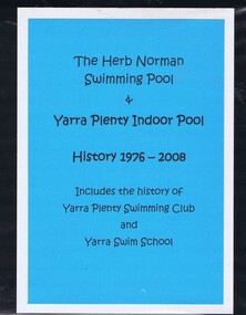
Folder (article and photographs), The Herb Norman Swimming Pool and Yarra Plenty Indoor Pool, history 1976-2008, comp. by Helen Webb, with a foreword by Rosie Bray, 2019_
History of the Herb Norman Swimming Pool, opened in 1978 and originally used by Watsonia High School; acquired by the Balwyn Yarra Swimming Club in 1984, which changed its name to the Yarra Swim School in the late 1980s. Includes the history of the Yarra Plenty Swimming Club and Yarra Swim SchoolLarge folder containing colour photographs, newspaper clippings and textyarra plenty swimming club, yarra swim school, watsonia high school, herb norman -
 Greensborough Historical Society
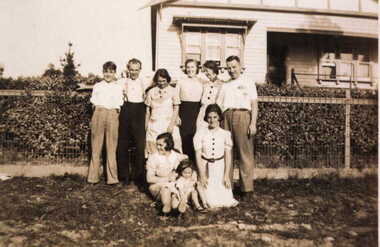
Photograph - Digital image, Barnett family at 122 Main Road Lower Plenty, 1930c
The Barnett family at 122 Main Road Lower Plenty. (Left to right, standing: Mick, Bill, Elsie, Ivy, Amile,Les,(Kneeling) Marg Barnett, Margaret Blackbourn, Margaret Barnett, Photographs from the collection of Peter Blackbourn, a descendant of the Chapman Stock family. Annotations to photos by Peter Blackbourn.Digital copy of black and white photograph.peter blackbourn, barnett family, 122 main road lower plenty -
 Ringwood and District Historical Society
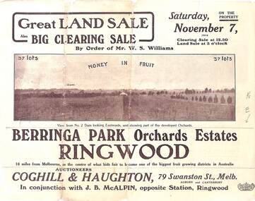
Pamphlet - Auction Sale, Berringa Park Orchards Estate, Ringwood, Victoria - 1914
Multi-fold brochure advertising public auction of 37 lots on Saturday 7th November, 1914. Brochure includes terms of sale, description of subdivision features and local facilities, and photographic images of the area. Three-page Park Orchards Estate Price List attached.Subdivison includes Smedley Road, Oban Road, Berringa Road, and Williams Road, North Ringwood. Auctioneers: Coghill & Haughton, 79 Swanston Street, Melbourne, in conjunction with J.G. McAlpin, Ringwood. Brochure includes Clearing Sale to be held same day for "everything required to work these orchards, from a packing needle to a traction engine ... comprising the most up-to-date and extensive farm & chaffcutting plant in this great district". -
 Ringwood and District Historical Society
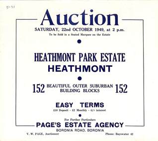
Flyer, Land Auction Sale Brochure, Heathmont Park Estate, Heathmont, Vic. - 1949
Double sided multi-fold advertisement for auction sale of residential allotments, including summary of subdivision features and local facilities. Auction on Saturday, 22nd October, 1949, at 2 p.m.Subdivision includes Great Ryrie Street, Erica Crescent, Neil Street, Frances Street, Viviani Crescent, and Canterbury Road. Agent - Page's Estate Agency, Boronia Road, Boronia. Phone Bayswater 42. -
 Ringwood and District Historical Society
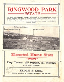
Flyer, Sub-divisional residential land sale advertisement - Ringwood Park Estate, Ringwood, Vic. - circa 1922
Folded double-sided page with black and white photographs of local views with black and red print advertising elevated home sites, including terms of sale, locality map, and description of local facilities and services, with blocks marked as SOLD subsequent to auction sale December 1922. (See Record ID no.5249)Subdivision includes Wonga Road (later Loughnan Road), William Street, Andrew Street, Munro Street and Harrison Street. Estate Agents - Keogh & King, 70 Elizabeth Street, Melbourne, Telephone 6938. -
 Eltham District Historical Society Inc
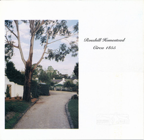
Auction Sale Brochure, Rosehill Homestead, 56 Bonds Road, Lower Plenty
Auction sale brochure, Miles Real Estate Professionals, RosannaBrochurehouses, bonds road, lower plenty, miles real estate, rosehill homestead -
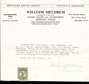 City of Moorabbin Historical Society (Operating the Box Cottage Museum)
Document - Document, deposit receipt 1950, c1950
Mr John Herron and his wife Isa Mary Herron purchased the house at 4 Vickery Street Bentleigh in 1950 from Miss M Marriott. He was a descendant of John James an early settler dairyman in Moorabbin Shire and Miss M Marriott was a descendant of the early settler market gardeners Marriott family. Mr Herron lived there until 1989 and the house was then demolished and turned into a carpark for the busy Shopping precinct of Centre Road, Bentleigh.The Marriott family were early settler market gardeners from 1878 in the area of Dendy’s 1841 Special Survey and John Herron was a descendant of Philip Jones , a chair-maker, who settled in the area of East Brighton, now Bentleigh, in 1852An original paper statement of receipt issued by William Meldrum for £100 deposit paid on March 28th 1950 by Mr John Herron for purchase of the house at 4 Vickery Street BentleighBENTLEIGH ESTATE AGENCY TAXATION & INSURANCE / WILLIAM MELDRUM / ESTABLISHED / 1908 Incorporating W.H.Wood & Co., Next Railway Station,/ SWORN VALUER and GOVERNMENT / APPROVED VALUER 367 a Centre Road / Bentleigh / Telephone XU 1404 / Fellow of the Real Estate and Stock Institute of Victoria / Associate of the Commonwealth Institute of Accountants/ Fellow of the Commonwealth Institute of Valuers Stamp in left bottom VICTORIA STAMP DUTY 3d with signature initials / Letter dated 28th day of March 1950 and signed SP W Meldrum / C Raveand pioneers, early settlers, brighton, moorabbin, bentleigh, market gardeners, dairyman, dairy farmer, jones james, jones mary ann, jones martha, jones elizabeth ann, dendy henry, dendys special survey 1841, elster creek, melbourne, jones ethel may, herron isa mary, herron john, tram conductor, marriott m, solicitors, valuers, taxation, meldrum w, real estate -
 Greensborough Historical Society
Advertisement - Digital image, Diamond Valley Local, Greensborough & Diamond Valley Estate Agent, 15/12/1954
These advertisements were collected from the Diamond Valley Local newspaper. Greensborough & Diamond Valley Estate Agent was a Main Street Greensborough estate agency. Advertisements for this agency occur in TROVE only in the year 1954.This advertisement is for a Greensborough based shop which no longer operates.Digital copy of newspaper advertisement.greensborough and diamond valley estate agent