Showing 112680 items
matching tracks/roads
-
 Ringwood and District Historical Society
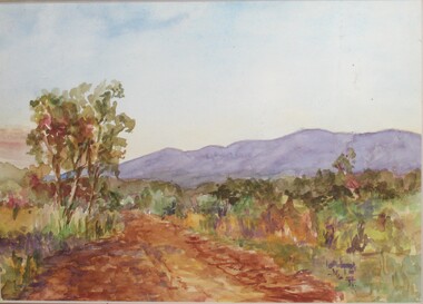
Painting, Winifred Miles, "Mullum Road" (Ringwood) - Water colour on paper by Winifred Miles (1884-1944), Undated, later than 1910
"Alexander Colquhoun [Herald art critic 1914-1922 and feature writer for the Age 1926-1941] ... took private students in the first decade of the century, and one of these was Winifred Miles, who after her marriage in 1910 lived the remainder of her life in Ringwood. ... (She) began by doing charcoal studies of animals when she was in Balranald, but in later years moved to oils and then watercolours, travelling around Ringwood to find places to paint by means of a pony-driven governess-cart. She won prizes for paintings in the Royal Melbourne Shows." - Hugh Anderson - Ringwood, Place of Many Eagles [p.217].Painting with cardboard border in glass-fronted frame. One of two undated paintings by Winifred Miles' viewed from the same vantage point on Mullum Mullum Road in Ringwood. (See Registration Number 4848)Sticker on back of frame - "Ringwood Framing Gallery, 233 Whitehorse Road Ringwood, Phone 8704930" -
 Ringwood and District Historical Society
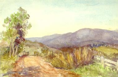
Painting, Winifred Miles, "Mullum Road" (Ringwood) - Water colour on paper by Winifred Miles (1884-1944), Undated, later than 1910
"Alexander Colquhoun [Herald art critic 1914-1922 and feature writer for the Age 1926-1941] ... took private students in the first decade of the century, and one of these was Winifred Miles, who after her marriage in 1910 lived the remainder of her life in Ringwood. ... (She) began by doing charcoal studies of animals when she was in Balranald, but in later years moved to oils and then watercolours, travelling around Ringwood to find places to paint by means of a pony-driven governess-cart. She won prizes for paintings in the Royal Melbourne Shows." - Hugh Anderson - Ringwood, Place of Many Eagles [p.217].Painting with cardboard border in glass-fronted frame. One of two undated paintings by Winifred Miles' viewed from the same vantage point on Mullum Mullum Road in Ringwood. (See Registration Number 4847)Sticker on back of frame - "Ringwood Framing Gallery, 233 Whitehorse Road Ringwood, Phone 8704930" -
 Bendigo Historical Society Inc.
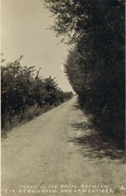
Postcard - ACC LOCK COLLECTION: TRACK TO THE BATHS BETWEEN ERQUINGHEM AND ARMENTIERES, POSTCARD, 1914-1918
Postcard, WW1, B&W image of the track to the baths between Erquinghem and Armentieres. A dirt track with bushes either side. Copy Z 33postcard, postcard, ww1, france, erquinghem, armentieres, baths -
 Bendigo Historical Society Inc.
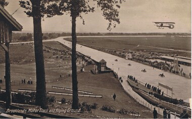
Postcard - BASIL WATSON COLLECTION: POSTCARD. BROOKLANDS MOTOR TRACK AND FLYING GROUND, ca. 1914
On bottom of postcard: 'Brooklands Motor Track and Flying Ground' . Track shown with four racing cars near finish. Biplane flying above this scene.Valentine's Seriesaviation, civilian, brooklands motor track -
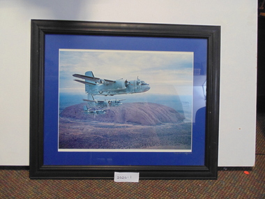 National Vietnam Veterans Museum (NVVM)
Photograph
A framed coloured photograph of three Navy trackers in formation near Ayers Rock (now called Uluru). The numbers on the Trackers are 852, 848, and 849photograph, navy trackers -
 Kew Historical Society Inc
Photograph - Flooding of the Yarra River in North Kew, 1934
North Kew, now divided between Kew and Kew East, bordered the Yarra River. As such, it was a region subject to flooding in the Yarra Valley. Development beyond this point (ie Kellett Grove) was limited by the City of Kew's planning regulations. Prior to urban development, the area since European settlement and the first land sales in the district in the 1840s, had been used for dairy farming. Small sepia snapshot of floodwaters taken from near Willsmere Road, in what was then known as North Kew. The point of view is looking towards Fairfield. In the foreground are two figures viewing a group in a rowboat in the middle of the flooded river. Semi-submerged street lighting indicates that entire streets had been. overwhelmed by the flood waters. Verso: WILLSMERE ROAD NORTH KEW / Stamped 3 163yarra river -- north kew, floods -- yarra valley, floods -- north kew, floods -- 1934, natural disasters -- kew, willsmere road -
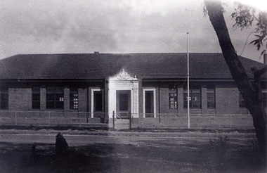 Whitehorse Historical Society Inc.
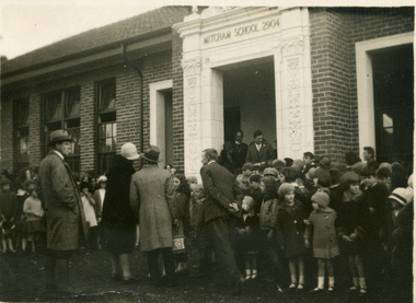
Photograph, Opening of the Mitcham State School No. 2904
The original Mitcham State School was built in 1888 and was closer to Mitcham Road, Whitehorse Road intersection than this 1929 (and present 2005) location. The donor, Helen Driscoll (nee Fitzsimone) was born in 1922 and lived at 20 Haines Street, Mitcham at the time of the opening.Black and white photograph of the opening of the Mitcham State School No 2904, Mitcham Road in 1929mitcham state school no. 2904 -
 Ballarat Tramway Museum
Sign, State Electricity Commission of Victoria (SECV), "CARS TAKE FOLLOWING LINE"
Galvanised sheet steel with top & bottom holes(central) & side mounting brackets & rounded corners. Painted with black base and white letters and lines used to indicate which depot track(Line) trams were to be parked or stabled on when returning to the depot. Depot had four under cover tracks (1 to 4) and one outside track ("0") road. Lettered as shown on the sketch on the original worksheet. Reg. Item No. 1170.1? shows the object in a wooden frame mounted onto a pole opposite the depot, by depot junction point.trams, tramways, depot, secv, ballarat, tramcar operations, operations -
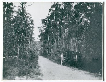 Orbost & District Historical Society
black and white photograph, 1913
This photograph shows the regrowth of vegetation on the road between Genoa and the border - now the Princes Highway.This is a pictorial record of the main road from Orbost to the New South border, The Princes Highway, in the early 20th century.A large black / white photograph of a bush road wwith a vehicle and a man on the side of it.on back - " Princes Highway showing the regrowth.....1913"princes-highway-genoa transport -
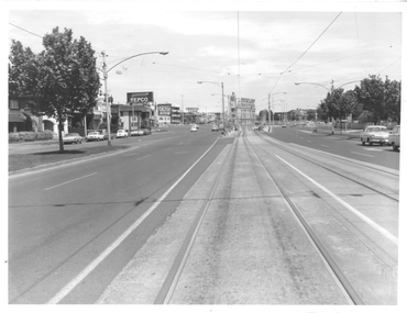 Melbourne Tram Museum
Photograph - St Kilda Road looking south, Melbourne & Metropolitan Tramways Board (MMTB), c1975
Photograph of the south end of St Kilda Road, before the full reconstruction of High Street St Kilda (now St Kilda Road) but after the reconstruction of the Queens Road underpass, photo c1975. Shows the buildings at the junction including the Tower Hotel in the distance. Signs for advertising include Repco, Caltex Astron, UniRoyal Tyres, and Dunlop Tyres. The "Timeline history of Melbourne Tramways etc Barry George et al" gives the date of the opening of the High St section as March 1975.Yields information about the redevelopment of St Kilda Junction.Black and White Photograph with notes on the rear.On rear of photograph in ink "St Kilda Road Junction Stage One complete c1975"trams, tramways, high st, st kilda junction, st kilda rd -
 Whitehorse Historical Society Inc.
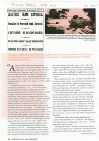
Article, Electric Tram Capsizes, 1917
In 1917, a tram capsized in Norwood (Toorak Road) after gathering too much speed which resulted in the death of a boy and injuries to 18 passengers.norwood road, burwood, toorak road, camberwell, tram services, trams -
 Glen Eira Historical Society
Album - Album page, Neerim Road, Circa 1972
This photograph is part of the Caulfield Historical Album 1972. This album was created in approximately 1972 as part of a project by the Caulfield Historical Society to assist in identifying buildings worthy of preservation. The album is related to a Survey the Caulfield Historical Society developed in collaboration with the National Trust of Australia (Victoria) and Caulfield City Council to identify historic buildings within the City of Caulfield that warranted the protection of a National Trust Classification. Principal photographer thought to be Trevor Hart, member of Caulfield Historical Society. Most photographs were taken between 1966-1972 with a small number of photographs being older and from unknown sources. All photographs are black and white except where stated, with 386 photographs over 198 pages. "Edenkillie" was the home of Frederick Jowett, Caulfield's shire secretary and town clerk from 1887 to 1921. The Outer Circle Railway's Oakleigh section opened 1890 and closed 1895. Victorian Heritage database (as of 26/10/2021) HO45 Edenkillie https://vhd.heritagecouncil.vic.gov.au/places/35545 "Edenkillie" at 37 Neerim Road, Glenhuntly, is a substantial two storeyed polychrome brick villa, built for Frederick Jowett, municipal secretary, in 1890. It has aesthetic, historical and social significance. "Edenkillie's" aesthetic value derives from its survival as a substantially intact example of a common villa form expressed in polychrome brickwork. Its historical significance lies in its association with Frederick Jowett, Shire of Caulfield secretary and town clerk for over three decades. Its social significance is derived from the building's ability to demonstrate the kind of lifestyle which a local government administrator could enjoy during the Land Boom.Page 145 of Photograph Album with four landscape photographs from Neerim Road: two photographs of No 37 and two of the Outer Circle Railway Reserve.Handwritten: Neerim Road [top left] / 37 NEERIM ROAD 1OCT 1972 [under top left photo] / 37 NEERIM RD 1 OCT 1972 [under top right photo] / OUTER CIRCLE RAILWAY RESERVE MURRUMBEENA [under bottom left photo] / 145 [bottom left]trevor hart, neerim road, murrumbeena, caulfield, edenkillie, glen huntly, polychrome brick, mansions, frederick jowett, town clerks, shire of caulfield, outer circle railway, railways, parks and reserves, outer circle railway reserve, cast iron work, verandahs, balconies -
Glenelg Shire Council Cultural Collection
Photograph - Photograph - Bridge Construction, 29/05/1957
Port of Portland Authority ArchivesFront: Back- 'Bridgewater road Bridge (otway street) 29/5/57' - pencilport of portland -
Whitehorse Historical Society Inc.
Map, Proposed shared path network, 2001
Draft plans of proposed shared path networkDraft plans of proposed shared path network for Eastern Freeway Extension, Springvale Road to Ringwood.Draft plans of proposed shared path network plans, eastern freeway extension, city of whitehorse, vicroads, city of maroondah, vicroads bicycle coordinator, footpaths, bicycle paths -
 Whitehorse Historical Society Inc.
Photograph, Opening of the Mitcham State School No. 2904, 1929
The original Mitcham State School was built in 1888 and was much closer to the Mitcham Road-Whitehorse Road intersection than the 1929 (and present 2005) location. The donor, Helen Driscoll (nee Fitzsimone) was born in 1922 and lived at 20 Haines Street, Mitcham at the time of the openingBlack and white photograph of the opening of the Mitcham State School No 2904, Mitcham Road in 1929mitcham state school no. 2904 -
 Melbourne Tram Museum
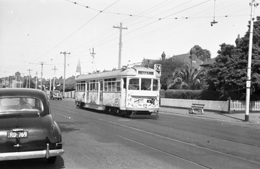
Negative - Tram 915 Centenary Car - Riversdale Road, Wal Jack, 11/02/1951
Photo by Wal Jack, of SW6 915, in Riversdale Road, Camberwell decorated for the 50th anniversary of Federal Government, 1951. Tram in bound to the City, Route 74 passing a stop 29 at Hasings Road. Note the shade in the overhead by the street light. Print dated 11-2-1951, though Wal Jack's album dates it as 9-2-1951. See also Reg Item 5179.Demonstrates a decorated tram.Black and white negative and copy print with photographers details on the rear."MMTB SW6 915 as Centenary Car from Burwood in Riversdale Road, Camberwell at Hastings Road stop no. 29, 11-Feb-1951 and Wal Jack Stamp with neg No. T693 written in,trams, tramways, sw6 class, riversdale road, tram stops, route 74, tram 915 -
 Hume City Civic Collection
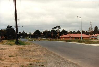
Photograph, early 1990s
The series of 5 photographs feature different views of the Woodlands Housing Development which opened up land bounded by Gap and Anderson Roads, Cornish Street and Elizabeth Drive in the early 1990s. It was a large housing development built close to Sunbury township.A coloured photograph of one of the last housing developments which took place in the old township area. It is a photograph taken at the north end of Anderson Road looking towards Gap Road. One house has been built and there are a number of 'For Sale' signs of blocks fronting Anderson Road. Guttering and driveways have been formed on one side of the road.housing developments, anderson road, george evans collection -
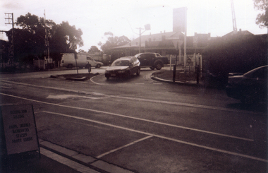 Whitehorse Historical Society Inc.
Photograph, The Railway Crossing from Station Street, 1/06/2009
One of a collection of photographs taken of the Nunawading Railway Station prior to the lowering of the railway line and building of the new railway station on the western side of Springvale Road so that the Springvale Road Rail Crossing can be eliminated.Black & white photograph of he precinct surrounding the Nunawading Station and the Springvale Road Railway crossing. This photograph is of the crossing from Station Street. The liquor on the corner of Springvale Road and Oval way is in the background. See NP 3545 to NP3567 for the complete set of photographsnunawading railway station, springvale road nunawading, redevelopment of railway line/springvale road., oval way nunawading -
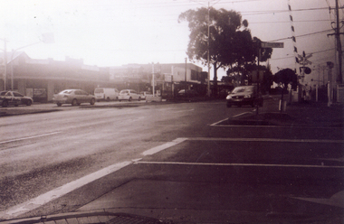 Whitehorse Historical Society Inc.
Photograph, Service Station -Now Works Site Office, 1/06/2009
One of a collection of photographs taken of the Nunawading Railway Station prior to the lowering of the railway line and building of the new railway station on the western side of Springvale Road so that the Springvale Road Rail Crossing can be eliminated.Black & white photograph of he precinct surrounding the Nunawading Station and the Springvale Road Railway crossing. This photograph is former Service Station on west side of Springvale Road. Now works site office. See NP 3545 to NP3567 for the complete set of photographsnunawading railway station, springvale road nunawading, redevelopment of railway line/springvale road. -
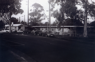 Whitehorse Historical Society Inc.
Photograph, General View of Nunawading Station, 1/06/2009
One of a collection of photographs taken of the Nunawading Railway Station prior to the lowering of the railway line and building of the new railway station on the western side of Springvale Road so that the Springvale Road Rail Crossing can be eliminated.Black & white photograph of he precinct surrounding the Nunawading Station and the Springvale Road Railway crossing. This photograph is view of the Nunawading Railway Station from Walker Road, showing the North an South Platforms. See NP 3545 to NP3567 for the complete set of photographsnunawading railway station, springvale road nunawading, redevelopment of railway line/springvale road., walkers road nunawading -
 Otway Districts Historical Society
Document, Victorian Parliamentary Papers, Minutes of Evidence, Beech Forest Narrow-Gauge Extension, July 1896
From the 9th April until the 8th July 1896 the Victorian Parliamentary Standing Committee on Railways, chaired by Mr. Cameron with members from both houses, took evidence on three narrow gauge extensions from broad gauge railway stations in the area, the Beech Forest Extension from Colac, the McDonald's Track Extension from Warragul, and the Drouin and Poowong East Extension from Drouin.Minutes of Evidence, Beech Forest Narrow-Gauge Extension. Minutes of Evidence, McDonald's Track Narrow-Gauge Extension. Minutes of Evidence, Drouin and Poowong East Narrow-Gauge Extension. Victorian Parliamentary Papers; Melbourne (Vic); April-July, 1896. 60 p. (VPARL1896-97 No 42) -
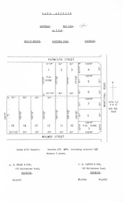 Ringwood and District Historical Society
Document, Auction Flyer - Hill's Estate, Wantirna Road, Ringwood - 1960
Typewritten details of Land Auction, 14th May, 1960, with map showing ten allotments in area bounded by Yarmouth Street, Wantirna Road and Walmer Street. Terms £100 Deposit. Residue £30 qrt including interest 6-1/2% Balance 5 years. (Agents) - A.T. Miles & Son, 175 Whitehorse Road, Ringwood WU.6215. C.E. Carter & Son, 126 Whitehorse Road, Ringwood WU.6024, WU.6830. -
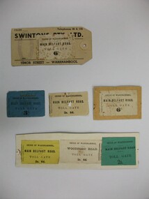 Warrnambool and District Historical Society Inc.
Document - Tickets, Toll road, 1866-1869
In 1866, in an effort to maintain the main roads of the region it was decided to establish toll roads on the Belfast, Woodford Purnim and Allansford roads. Gates were erected and the leases were disposed of by auction. In 1867 the Woodford tollhouse was destroyed by fire suspected to be deliberate. The tolls were removed three years later after much opposition. These tickets are a physical link to one of the earliest attempts to introduce a toll road in the district. Seven toll road tickets five mounted on card. Light paper. Six are for the Main Belfast Road and one for the Woodford road. There are various prices ranging from sixpence to three shillings. Four are cream in colour, one each of blue, yellow and green. They are accompanied by a small newspaper cutting which relates the discovery of one such ticket and the situation of the Belfast tollhouses which were later relocated to 94 and 96 Henna Street near the Alderdice brass foundry.Shire of Warrnambool, Fairfax & Laurie Printers. tollgate, tollgate tickets, woodford toll tickets, shire of warrnambool -
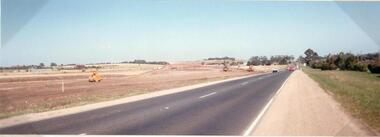 Hume City Civic Collection
Photograph
This photograph is of the duplication of the Calder Highway at Diggers Rest in the vicinity of Plumpton Road.A coloured panoramic view of the construction of the duplication of the Calder Highway in the vicinity of Plumpton Road. It is unmounted.calder highway, diggers rest, highway duplication, road construction and maintenance, plumpton road, george evans collection -
Whitehorse Historical Society Inc.
Document, Certificate of Title - George Albert Smith, 1928, 1934
Certificate of TitleCertificate of Title for Lot 13 Railway Road, Mitcham and correspondence re outstanding rates.Certificate of Title shire of blackburn and mitcham, land titles, rates, smith, george albert, east road, mitcham, creek road, mitcham, railway road, mitcham, lot 13 -
Glenelg Shire Council Cultural Collection
Postcard - Postcard - Portland Harbour, 1930s
Owned by James and Ada Brimblecomber, Heywood, and then by Merle Lewis, Mt. Gambier.Black and white photographic image of a harbour with two long piers running into it and a shorter jetty with a building on it and a circular jetting protruding from it. In the foreground are trees, a dirt road with an RACV sign bridging it to the right and a railway track visible between the trees.Front: THE HARBOUR, PORTLAND (printed, lower centre) -
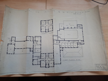 Vision Australia
Plan - Image, Royal Vic Institute for the Blind Hirings Service, 18/12/1943
Plan of the first and second floors of the main building at 557 St Kilda Road, created by the RAAF during it's occupation of the same between 1942-1944.1 architectural plan of St Kilda Road main buildingroyal victorian institute for the blind, plans, raaf -
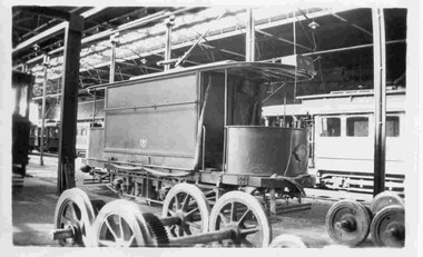 Ballarat Tramway Museum
Photograph - Black & White Photograph/s, Keith Kings, Apr. 1949
Black and White photograph contained with Reg. Item 1902 - Photo Album from Keith Kings to Les Denmead 1970. Photograph of SEC Bendigo - original sprinkler and track cleaning tramcar at the depot, Easter Monday 4/1949. Photographed inside the depot with maximum traction driving wheels in the foreground. Other trams in the background. Keith Kings No. B(y)(6) Scanning: i - image file, p - presentation file, b - back of photograph.Stamp in top left hand corner and handwritten number with "K.S. Kings No. B(y)(6) Copyright reserved". In blue ink "Bendigo / The original Sprinkler and track cleaning car / Depot / Easter Monday / 4/49"trams, tramways, bendigo, sprinkler tram, track cleaner, scrubber tram, depot, tram sprinkler, tram scrubber -
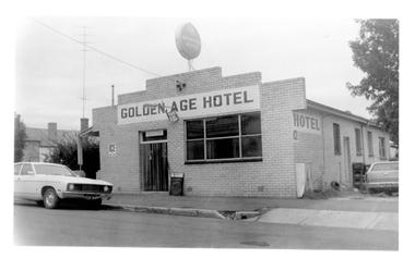 Tarnagulla History Archive
Photograph of the Golden Age Hotel, Tarnagulla, Late 1960s
Murray Comrie Collection. Building is still operating as the Golden Age Hotel on Commercial Road, Tarnagulla.Monochrome photograph depicting the Golden Age Hotel, located in Commercial Road, Tarnagulla.tarnagulla, commercial road, golden age hotel, buildings -
Phillip Island and District Historical Society Inc.
Photograph
Part of collection of Photographs donated to the museum by the family of the late Mr. Jack Jenner (1977)Sepia Postcard - View of bush track, Cowes.Labelled "Lovers Walk, Cowes, Phillip Island".local history, photography, photographs, slides, film, view cowes, sepia photograph, jack jenner, lovers walk cowes, phillip island