Showing 123797 items matching "main-road"
-
 Kew Historical Society Inc
Photograph, Deepdene
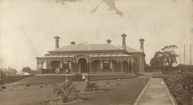
Rare photograph of a significant Melbourne home.Photograph of the historically significant house, Deepdene, which was located before demolition on the southeast corner of Burke Road and Cotham Road. The photograph is on the back of a subdivision plan of the Auburn Heights Estate.deepdene -
 Canterbury History Group
Photograph - Maling Road shops, Jan Pigot, 27/03/1993 12:00:00 AM
Coloured photograph of Shop No.122 Maling Road - Antique, Restorations and Furniture Dealer and Shop No.120 Maling Road - Farren-Price-fashion accessories, with the back of the Canterbury Mansions in view.canterbury, maling road, shops, canterbury mansions, palm tree, street signs -
 Kew Historical Society Inc
Photograph - Construction of the Eastern Freeway (F19), Ron Setford, March 1972
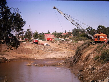
Ron Setford and his wife Grace Setford lived in Tanner Avenue, East Kew, from c.1946 to c.1995. A keen photographer, he recorded the changing face of Kew over a 20 year period. Apart from 30 photographs of built structures and places in Kew dating from 1960 and 1961, 145 of his 35mm colour slides chronicle the development of the F19 (later renamed Eastern) Freeway through the Yarra Valley in Kew over a five year period from c.1972 to c.1977. This important collection was donated to the Society by his granddaughter in 2025.This collection of 175 35mm slides is of local and statewide significance, owing to its subject matter, particularly the major development of road transport infrastructure during the 1970s with the construction of the Eastern Freeway. The photographer also took care to annotate and date most of his slides which enable the researcher to pinpoint temporal and spatial locations.Photograph of works involved in construction of the F19 (now Eastern) Freeway. The photo shows works diverting the former river bed of the Yarra near Kilby Road and Willsmere Road, Kew."Eastern Freeway / Old River Bed / Kilby-Willsmere Rd"ron setford, eastern freeway, f19 freeway -
Canterbury History Group
Photograph - Street view of the corner of Maling Road and Bryson Street depicting the shop No. 92. Maling Road, Jan Pigot, 1994
Coloured photograph of the street view of the corner of Maling Road and Bryson Street depicting Buckley's Supermarket at shop No. 92. Maling Road This is also the corner of the building named The Block 1907.canterbury, maling road, shops, bryson street, buckley family, the block -
 Lakes Entrance Historical Society
Photograph - Bunga Rd. 2008, Wendy Price, 1/08/2008 12:00:00 AM
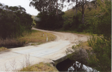
This photograph was used in the 150 year display Lakes Entrance 1858 to 2008 paired with image number 03728 as the after pictureColour photograph of old Bunga Road crossing this was part of the old coach road which went from Lakes Entrance via Lake Tyers to Orbost, Lakes Entrance Victoriaroads and streets, development -
 Ringwood and District Historical Society
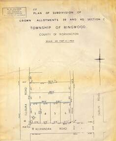
Map - Plan of Subdivision, Part of Crown Allotments 39 and 40 Section C, Township of Ringwood, County of Mornington - (Undated - circa 1930s)
Copy of land title map on light cardboard backing showing layout and size of 6 allotments in Illoura Road (later Illoura Avenue) and Alexandra Road, Ringwood East, Victoria. Rubber stamp imprint in top left corner - D.H. Oliver, Civil Engineer & Licensed Surveyor, Bellevue Street Lilydale, Phone Lilydale 91. -
 Eltham District Historical Society Inc
Photograph - Aerial Photograph, Landata, Lower Plenty, Vic, Apr. 1963
Centred on present day Old Eltham Road near Araluen Centre, Lower Plenty bounded by Cromwell Street to north, Yarra River to south, Main Road at Mount Pleasant Road to east and Panorama Avenue to west. Historic Aerial Imagery Source: Landata.vic.gov.au Aerial Photo Details: Project No :486 Project : MELBOURNE (1963) PROJECT Run : 7 Frame : 231 Date : 04/1963 Film Type : B/W Camera : RC8 Flying Height : 5100 Scale : 9600 Film Number : 1805 GDA2020 : 37°44'03"S, 145°07'56"E MGA2020 : 335420, 5822027 (55) Melways : 21 F10 (ed. 42)aerial photo, neil webster collection, 1963-04, araluen, cromwell street, eltham, lower plenty, main road, melway 21f10, mount pleasant road, old eltham road, panorama avenue, yarra river -
 Phillip Island Conservation Society Inc.
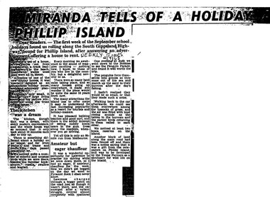
Work on paper - Photocopy of newspaper cutting, Herald and Weekly times, "MIRANDA TELLS OF A HOLIDAY ON/ PHILLIP ISLAND"
Miranda was a very popular journalist of this era, whose homely style appealed to many readers, especially women, her main audience in her writing. Here she talks about renting a new demonstration holiday home (probably a Coldon Home), which, although small, had a 'dream kitchen'. She describes the birds and walk through the wattle to the beach, but also the many blocks for sale and wonders what the island will be like in 10 years time from their visit. Her son drove them to Pyramid Rock where they almost got bogged on the road. They visit the usual spots, which she describes with a combination of curiosity and enjoyment. She also mentions another block fenced off on the main road which was a gift from the ratepayers of Phillip Island, and which the Young Farmers were to plant out for koala trees.This article is significant because thousands of Weekly Times newspaper readers read Miranda’s letter article without fail each edition. She describes renting a house for a holiday, which indicates the move away from family holidays in guest houses. She also describes some of the rough roads in parts of the island at the time. She concentrates on the island’s natural attractions rather than man- made tourist attractions, which is also significant in letting us see why people would visit Phillip Island in that era. Miranda also predicts the explosion of the holiday home owner market which took place soon after, and continues today though in a more controlled way.Photocopy of newspaper article cut out from full page. Cutting has three columns of text, no images. Black text on white paper. Dark areas due to poor photocopyingWEEKLY TIMES / 2/9/65phillip island, miranda, weekly times newspaper, holiday home, phillip island flora and fauna, pyramid rock, phillip island pengiun parade, young farmers, phillip island beaches, cuddly koala bears, phillip island housing estate land sales -
 Ringwood and District Historical Society
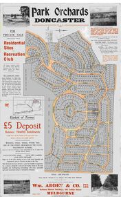
Map, Park Orchards Land Sale Advertisement, Doncaster, Victoria, Circa 1926
Large linen backed map of the Park Orchards subdivision for private sale of residential sites and recreation club, highlighting local facilities, services and layout of the estate. Surveyors - Tuxen & Miller, 34 Queen Street, Melbourne. Agents - Wm Addey & Co., Pty Ltd., National Mutual Buildings, 395 Collins Street, Melbourne, Phone F3906. Terms £5 deposit balance monthly installments of £1 with the residue at the end of five years. Subdivision includes Alva Avenue, Arundel Road, Aviemore Avenue, Berringa Road, Bowmore Avenue, Brucedale Crescent, Brympton Avenue, Camber Avenue, Cawdor Avenue, Colin Avenue, Corriedale Crescent, Craithie Avenue, Daintree Avenue, Dalry Avenue, Dirlton Crescent, Drayton Crescent, Elgin Crescent, Enfield Avenue, Ennismore Crescent, Euston Avenue, Feversham Avenue, Frogmore Crescent, Gosford Crescent, Granard Avenue, Hopetoun Road, Hylton Avenue (later Knees Road), Jura Avenue, Park Road. -
![Flooding at Chipperfield's Boathouse [East Kew], 1934](/media/collectors/550653872162f11fb04854aa/items/58cbaad5d0cec425b474bfb1/item-media/58cf6fbdd0cf9f331490feb0/item-fit-380x285.jpg) Kew Historical Society Inc
Kew Historical Society IncPhotograph, Flooding at Chipperfield's Boathouse, 1934
Living with natural processes was frequently a challenge to early European settlers and later residents of what was in the 1850s administered by the Borondara Road Board. This was compounded by the area being bounded on three sides by rivers (Yarra River, Koonung Creek and Gardiner's Creek). In 1849, the historian James Bonwick recorded that "our district [Kew] suffered considerably. Mr Wade speaks of 80 acres, out of 100 acres of his cultivated paddock, covered by water." Newspapers continued to describe major flooding in Kew in 1863, 1869, 1878, 1880, 1889, 1891, 1916 and 1934. While the construction of the Upper Yarra dam in 1957 reduced the levels of flowing downstream, local and riverine floods continue.The Kew Historical Society's pictures and map collections testify to the impact of flooding in the district. They have historical importance in documenting the extent of flooding in the district and its affects on homes, services and recreation. Numerous photographs record flooding throughout the Twentieth Century.Floods in North Kew, 1934. Chipperfield's Boathouse and the adding Moorings was located beside the Yarra River near the corner of Willsmere and Kilby Roads. The flood reached the roof of the Moorings, which can be seen in the photo.floods (kew), floods (kew) 1934, yarra river -
 Surrey Hills Historical Society Collection
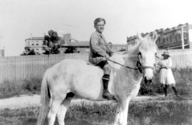
Photograph, Bill Willaton on one of Tacey's butcher's shop delivery horses, c 1920, 1920
The date is approximate. Bill Willaton was a driver for C E Gray & Son, bakers of Canterbury during the 1930s. Tacey's butcher shop (dem) was located at 629 Canterbury Road. Black and white photo of a young boy on a light-coloured horse in vacant land adjacent to Canterbury Road, Surrey Hills. In the background a girl is standing in front of a new-looking paling fence behind which can be seen local landmarks. On the right is Hansen's Terrace; on the far left part of the Surrey Hall can be seen and in the middle ground the rear of McNeill's Family Hotel (Surrey Lodge), Dartnell's corner and the side of the post office.tacey's butchers, horse-driven vehicles, hansen's terrace, surrey hills post office, surrey lodge, mcneill's family hotel, surrey hall, william willaton, bill willaton, surrey hills, canterbury road -
 Warrnambool and District Historical Society Inc.
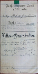
Document - Ann Doran Letters of Administration 1911, 1911
Tait collection: item 30 of 62 This document contains information on the Letters of Administration of Ann Doran of Port Fairy Road, Warrnambool. She died in December 1889 but, as she died intestate, the Letters of Administration were not processed until 1911. Ann Doran left no real estate but left personal estate to the value of £116. The sole beneficiary was her daughter, Jane Doran. The lawyer in the case was Ernest Chambers who had legal offices in Port Fairy, Warrnambool and Koroit at the end of the 19th century and the beginning of the 20th century. He had this document in his possession and it was passed down to successive lawyers occupying the legal premises in Kepler Street. It was located in this building in 2014 and passed on to the Warrnambool and District Historical Society at that time. This document is of some interest as it contains information on the Letters of Administration of Ann Doran who lived in Warrnambool at the time of her death in 1889. It will be of use to researchers. This is a cream-coloured piece of parchment paper folded in two with handwritten material on two sides. One page has ruled black lines. A seal of the Supreme Court of Victoria is attached with a green ribbon and there are four red stamps of the Master in Equity of the Supreme Court. One page is somewhat stained.In the Supreme Court of Victoria; In the Probate Jurisdiction; In the Estate of Ann Doran late of Port Fairy Road Warrnambool in the State of Victoria married woman deceased intestate. Letters of Administration.ann doran, ernest chambers, warrnambool -
Federation University Historical Collection
Plan, Mount Helen Campus Plan, 1997, 1997
The Union Building was later named the Albert Coates Centre, and the Aboriginal Education Centre moved from T Building to the first floor of the Albert Coates Centre in 2011. Mount Helen Campus Plan showing the location of buildings and roads. mount helen campus, campus plan, union builidng, aboriignal education unit, albert coated building -
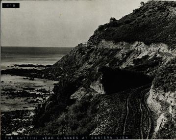 Lorne Historical Society
Photograph, The Cutting near Clarke's at Eastern View
Photograph of the cutting, fence and road near Clarke's at Eastern Viewg.o.r eastern view: cutting near clarke's: fencing: -
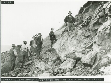 Lorne Historical Society
Photograph, Workmen at Big Hill
Photograph of a group of workmen at Big Hill on the Great Ocean Roadg.o.r; big hill: -
Phillip Island and District Historical Society Inc.
Postcard
This Postcard came from the Estate of Keith McIlwraith on 20th July, 1983Road to the Back Beach, about 1.5 kilometres from Coweslocal history, documents, postcards, early postcards, postcard, beaches, phillip island -
Phillip Island and District Historical Society Inc.
Postcard
This Postcard came for the Estate of Keith McIlwraith on 20th July 1983.Mr. Robertson at the Shell House, Nobbies Road, Phillip Island.local history, documents, postcards, early postcards, postcard, shell house, phillip island -
Phillip Island and District Historical Society Inc.
Photograph, 1990
This photograph taken by Jack Eddy for the Phillip Island Cemetery Trust. Phillip Island Cemetery dates from 1870Photograph of the entrance to Phillip Island Cemetery from Coghlan Road."Phillip Island Cemetery"local history, photography, photographs, slides, film, phillip island cemetery, entrance, coloured photograph -
 Phillip Island and District Historical Society Inc.
Photograph, 1978/79
Timber house with verandah built probably early 1900s.Coloured photograph of the home of Percy McFee, Newhaven-Rhyll Road.local history, photographs, buildings - historical, coloured photograph, john cook, phillip island, p mcfee homestead -
Glenelg Shire Council Cultural Collection
Slide - Slide - Construction Portland/Cashmore Airport, c. 1980
Coloured slide. Road making equipment working on runway site. -
Glenelg Shire Council Cultural Collection
Photograph - Photograph - Cape Grant Quarry, 27/08/1953
Port of Portland Authority ArchivesBack: Purple PHT stampport of portland archives, cape grant quarry -
Glenelg Shire Council Cultural Collection
Photograph - Photograph - Cape Grant Quarry, 27/08/1953
Port of Portland Authority ArchivesBack: Purple PHT stampport of portland archives, cape grant quarry -
Glenelg Shire Council Cultural Collection
Photograph - Photograph - bulk storage, n.d
Port of Portland Authority Archivesport of portland archives, bulk storage -
Glenelg Shire Council Cultural Collection
Slide - Slide - Cashmore Airport, Portland, 1980s
Coloured slide. Road making equipment working in bottom of excavation.portland airport, cashmore, engineering, air travel, construction -
Glenelg Shire Council Cultural Collection
Photograph - Photograph - Casterton Victoria, n.d
Sourced from Casterton Town Hall (former Shire of Glenelg)Black and white photograph of a car on dirt road near bridge. -
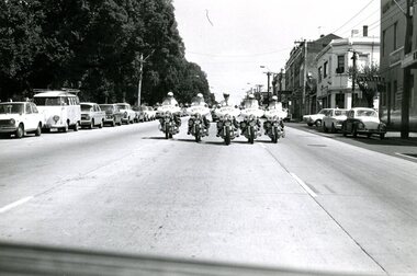 Victoria Police Museum
Photograph (police motorcycle), February 1973
Five Victoria Police officers on motorcycles escort Cardinal Shehan in Melbourne for the 40th International Eucharistic Congress, February 1973Motorcycle police riding five abreast along a city road.police vehicles; wireless patrol; motor transport branch; motor transport section; motor cycle patrol; police motorcycles -
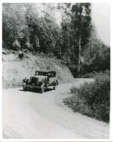 Victoria Police Museum
Photograph (police car), Kodak
Daimler 35HP sedan. Used as transport for the Chief Commissioner after having been badly damaged in an accident in Brighton in 1931.Daimler (registration number 931) on unsealed road. Circa 1926police vehicles; transport; motor police branch; daimler car; wireless patrol -
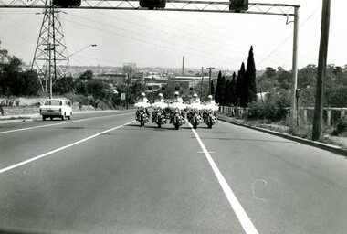 Victoria Police Museum
Photograph (police motorcycle)
Five Victoria Police officers on motorcycles escort Cardinal Shehan in Melbourne for the 40th International Eucharistic Congress, February 1973Motorcycle police riding five abreast along a city road.police vehicles; wireless patrol; motor transport branch; motor transport section; motor cycle patrol; police motorcycles -
Ringwood and District Historical Society
Book, Borough of Ringwood Ledger Country Roads Board
Bound book "Borough of Ringwood Ledger Country Roads Board" -
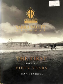 Ringwood and District Historical Society
Book, Yarra Valley Grammar School - The First 50 Years - 1966-2015
History of Yarra Valley Grammar School, Kalinda Road, Ringwood.