Showing 110332 items matching "roads"
-
 Eltham District Historical Society Inc
Negative - Photograph, Popular Picnicing at Hurstbridge, c.1925
Picnickers enjoying a Sunday outing near the Wattle Valley Estate at Hurstbridge. Copied from brochure "Wattle Valley Estate". It is believed the picture is taken at the northwest corner of the intersection of Wattletree Road and Hurstbridge-Arthurs Creek Road looking southeast towards the township (most likely where the house is located on the property of what is today No. 2 Wattletree Road)- https://goo.gl/maps/VDorwCe1rJJUapjE6 According to a comment by Jean Verso (via @nillumbikcouncil FB page 3 Jan 2020) - "This view is from Wattle Tree Road with Haleys Gully Road to the right and across the creek to William Gray's nursery at Allwood. The building to the far left looks like Dorset House. The building on the left in the middle distance is still there today and has been used for storage and as a stable/tack room for a number of years." The Wattle Valley Estate was first advertised in August 1925 as weekend building allotments by the Greater Melbourne Land and Development Company. Advertised from £28.10.0 or £60 per block. In August 1926, 30 picked allotments of 60x150 feet were put up for auction Saturday August 14, 1926 with frontages to Valley View Road and Fawkner Crescent advertised in the “Heart of the Glorious Wattle Country” and “Within 15 Minutes of the Newly Electrified Railway Station”. The Advertiser on August 13, 1926 in an article promoting the auction stated “the estate is regarded as one of the best in the district, and will be sold practically without reserve.” It is noted that an advertisement running in The Argus February 22, 1951 offered the remaining 16 blocks for sale at £12.10.0 or £200 the lot. By March 7, the remaining blocks were advertised at £17.10.0 The Wattle Valley Estate took over 20 years to sell and then people could not build on them Cross Ref EDHS_02665 Rose Series Postcard P. 4341, "View at Hurstbridge, Vic." Also, other images from sales brochure SEPP_1055 / 1056This photo forms part of a collection of photographs gathered by the Shire of Eltham for their centenary project book,"Pioneers and Painters: 100 years of the Shire of Eltham" by Alan Marshall (1971). The collection of over 500 images is held in partnership between Eltham District Historical Society and Yarra Plenty Regional Library (Eltham Library) and is now formally known as the 'The Shire of Eltham Pioneers Photograph Collection.' It is significant in being the first community sourced collection representing the places and people of the Shire's first one hundred years.Digital image 4 x 5 inch B&W Neg1925, dorset house, fawkner crescent, haleys gully road, hurstbridge, hurstbridge-arthurs creek road, picnic, postcards, shire of eltham pioneers photograph collection, valley view road, wattle valley estate, wattletree road, exhibition yprl 2019-12 -
 Eltham District Historical Society Inc
Photograph - Postcard, Rose Stereograph Company, View at Hurstbridge, Vic, c.1925
Rose Series Postcard P. 4341 “View at Hurstbridge, Vic.” Picnickers enjoying a Sunday outing near the Wattle Valley Estate at Hurstbridge. Copied from brochure "Wattle Valley Estate". It is believed the picture is taken at the northwest corner of the intersection of Wattletree Road and Hurstbridge-Arthurs Creek Road looking southeast towards the township (most likely where the house is located on the property of what is today No. 2 Wattletree Road)- https://goo.gl/maps/VDorwCe1rJJUapjE6 According to a comment by Jean Verso (via @nillumbikcouncil FB page 3 Jan 2020) - "This view is from Wattle Tree Road with Haleys Gully Road to the right and across the creek to William Gray's nursery at Allwood. The building to the far left looks like Dorset House. The building on the left in the middle distance is still there today and has been used for storage and as a stable/tack room for a number of years." The Wattle Valley Estate was first advertised in August 1925 as weekend building allotments by the Greater Melbourne Land and Development Company. Advertised from £28.10.0 or £60 per block. In August 1926, 30 picked allotments of 60x150 feet were put up for auction Saturday August 14, 1926 with frontages to Valley View Road and Fawkner Crescent advertised in the “Heart of the Glorious Wattle Country” and “Within 15 Minutes of the Newly Electrified Railway Station”. The Advertiser on August 13, 1926 in an article promoting the auction stated “the estate is regarded as one of the best in the district, and will be sold practically without reserve.” It is noted that an advertisement running in The Argus February 22, 1951 offered the remaining 16 blocks for sale at £12.10.0 or £200 the lot. By March 7, the remaining blocks were advertised at £17.10.0 The Wattle Valley Estate took over 20 years to sell and then people could not build on them Cross Ref SEPP_1057, “Popular Picnicing at Hurstbridge” rcopied from Wattle Valley estate sales brochure.Digital file only Postcards scanned from the collection of Michael Aitken on loan to EDHS, 13 Feb 20181925, dorset house, exhibition yprl 2019-12, fawkner crescent, haleys gully road, hurstbridge, hurstbridge-arthurs creek road, michael aitken collection, picnic, postcards, rose stereograph company, shire of eltham pioneers photograph collection, valley view road, wattle valley estate, wattletree road -
 Eltham District Historical Society Inc
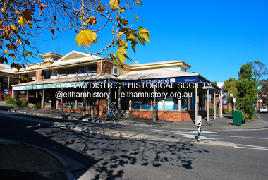
Photograph - Digital Photograph, Jim Connor, Eltham Village Shopping Centre, corner Arthur Street and Main Road, Eltham, 3 July 2013
Site of the former Eltham Shire Council offices and Public Hall, opened November 21, 1941. Council built new offices at 895 Main Road in 1964 and the site was sold to Woolworths in 1970.jim connor collection, arthur street, ella bache, eltham shopping centre, eltham village, eltham village shopping centre, main road, shopping centre -
 Eltham District Historical Society Inc
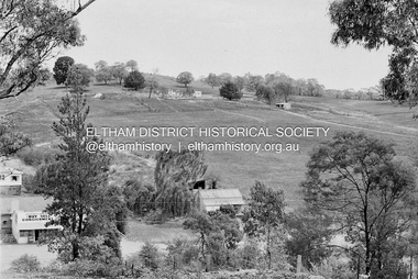
Photograph, Barry Philp, Second Hand store at the southeast corner of Reynolds Road and Main Road, Eltham, c.1969
Corner of Reynolds Road. The store is on the left, the house on the right was the home of the Dodkins family (Phographer Barry Philp's uncle and aunty). The house on the hill was Philbrick's home which burnt out in the bush fires.bushfires, dodkins family home, fire damage - buildings, main road, philbrick family home, research (vic.), reynolds road, second hand dealer, victorian bushfires - 1969, eltham, eltham-yarra glen road -
 Glen Eira Historical Society
Article - Koornang Road, 2/404, Carnegie
Article with colour photographs (interior and exterior) concerning sale of home unit at 2/404 Koornang Road dated 04/04/2006. Auction to be held on 06/05/2006. Source unknown.carnegie, koornang road, home units, auctions -
Glen Eira Historical Society
Article - Koornang Road, 158, Carnegie
An article dated 11/10/2006, source unknown, describing the property at 158 Koornang Road and noting its forthcoming auction on 12/10/2006. Includes a colour photograph of the building exterior.carnegie, koornang road, shops, dry cleaners, shopping centres, flats, auctions, sandra’s dry cleaners -
Glen Eira Historical Society
Article - Koornang Road, 197, Carnegie
Article Dated 08/12/2003, Source Unknown, with Brief Description of 197 Koornang Road And Noting Forthcoming Auction On Following Saturday. Includes One Exterior And Two Interior Colour Photographs.carnegie, koornang road, auctions, houses -
 Glen Eira Historical Society
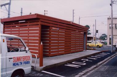
Photograph - Glenhuntly Road, Glen Huntly
Two colour photographs of a public toilet block on Glen Huntly Road, north side west of the railway line. The photographs may date to the 1980s though the exact dates are unknown. Photographer unknown.glen huntly road, glenhuntly, glenhuntly road, glen huntly, toilets, public conveniences -
 Greensborough Historical Society
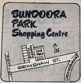
Photograph - Newspaper Clipping - Digital Image, Diamond Valley News, Bundoora Park shopping centre 1971, 1971
in 1971 this area was called Bundoora Park and the shops had same name. It has been renamed Andrew Place Shopping Centre as people confused it when Bundoora Park in Plenty Road opened. Digital copy of newspaper advertisementbundoora park shops, andrew place shops, grimshaw street bundoora -
 Greensborough Historical Society
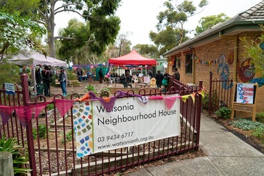
Photograph - Digital Image, Marilyn Smith, Watsonia Neighbourhood House, 15/06/2019
Watsonia Neighbourhood House, 47 Lambourn Road Watsonia. Provides adult education classes and workshops, as well as social and mutual-support activities. This photogrsph was taken at the Sustainable Watsonia Open Day 2019.Digital copy of colour photographwatsonia neighbourhood house, lambourn road watsonia, neighbourhood houses -
 Greensborough Historical Society
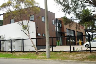
Photograph - Digital Image, Eltham Ambulance Branch from Looker Road, 2018, 1930s
Eltham Ambulance Branch, Apex Way Montmorency. The original ambulance station on this site was opened in 1975 and demolished in 2017. This photograph shows the new ambulance station, opened in 2018, from Looker Road.Digital copy of colour photographeltham ambulance station, ambulance victoria, apex way montmorency, looker road montmorency -
 Greensborough Historical Society
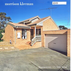
Advertising Leaflet, 1/3 Airlie Road Lower Plenty, 24/09/2018
1/3 Airlie Road Lower Plenty. 2 bedroom unit. Sold 24/09/2018 for $610,000. Previous sales: September 2015 for $452,000, and May 2007 for $269,750. Built 1990.Real Estate advertising leaflet,1 sheet folded into 4 pages, printed in colour both sides. 2 copies.airlie road montmorency -
 Greensborough Historical Society
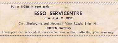
Advertisement - Digital Image, Esso Service Centre 1968, 25/08/1968
Advertisement for Esso Service Centre corner Sherbourne and Mountainview Roads Briar Hill. Proprietors: J.A & A.M Opie. Copied from a Diamond Valley Football League football record from 1968.Digital copy of advertisement from booklet.diamond valley football league, esso service centre, mountainview road briar hill, sherbourne road briar hill -
 Greensborough Historical Society
Photograph - Digital image, John Blackbourn, 1939_
John Blackbourn, born 1936; taken at corner of Old Eltham Road and Main Street. Photographs from the collection of Peter Blackbourn, a descendant of the Chapman Stock family. Annotations to photos by Peter Blackbourn.Digital copy of black and white photograph.peter blackbourn, john blackbourn -
 Greensborough Historical Society
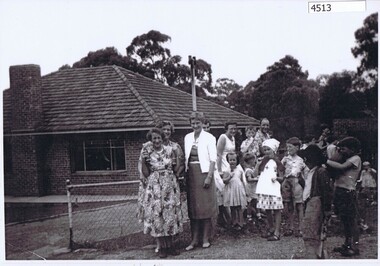
Photograph (copy), Family group, Greenhill Road Greensborough, 1958c
Family group, including Granny Andersen (far left), daughter Dot Turner (3rd from left) and daughter June Thorp (5th from left). Photograph taken in Greenhill Road Greensborough.Black & white photograph, enlarged and laminated.granny andersen, dot turner, june thorp, greenhill road greensborough -
 Emerald Museum & Nobelius Heritage Park
B/W Photograph, 1945
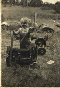
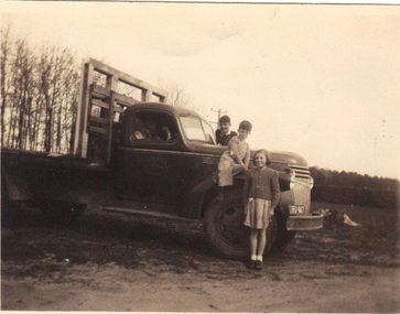
Jack Hirst owned a property on Paternoster Road, Emerald, where this photograph was taken. He was a general carrier of goods for the district. One of the boys in the photograph is his son. The girl is a member of the Nobelius family.The photograph is a record of prominent families in the Emerald district.B/W photograph of three children standing beside a truck belonging to Jack Hirst at a rural property.FRONT: Truck registration plate VIC FU 947 REAR: Jack Hirst's truck (Jack obscured). John Richardson, Alan Hirst and Elaine Nobelius. 1937 Truck soursed [sic] from Canada. Kodak Print 1215nobelius family, emerald football club, hirst -
 Learmonth and District Historical Society Inc.
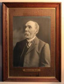
Photo.Rain W, Richards & Co. Photos Ballaarat, William Rain
William Rain was Auditor of Ballarat Shire and Road Board, during the period 1873-1890.He was also a teacher in Sunday School at Learmonth Uniting Church 1884-1887,and Superintendent 1887-1930. Original Historic PhotoPhoto of William Rain,is Sepia in colour and set In dark Brown frame (moulded),with gold trim on inner edge and dark brown mount with "wood grain " effect.Name plate is gold metal set at bottom of mount.William Rain.ballarat shire council, rain william, auditor 1873 1890, learmonth uniting church sunday school teacher 1884 1887 -
 Eltham District Historical Society Inc
Photograph, Eucalyptus Road, Eltham, 15 October 1990
Looking south towards Pitt Street and Nyora Road. Bus stop now on opposite side. Pauline Toner Butterfly Nature Conservation Reserve managed by Parks Victoria on the right hand side. Roll of 35mm colour negative film, 6 of 7 stripsKodak Gold 100-2 5095infrastructure, roadworks - gutters, shire of eltham, streets, eucalyptus road, pauline toner eltham copper butterfly reserve, pauline toner butterfly nature conservation reserve -
Glen Eira Historical Society
Letter - Lady Mackey
This file contains 1 item: 1/A letter from Philipe Batters with a business card attached announcing Lady Mackey’s opening of a floral studio at her house, 24 Narong Road, Caulfield.mackey lady, caulfield, narong road, florists, lady mackey floral studio, batters philipe -
Glen Eira Historical Society
Document - Residential Certificate 1909-11
This file contains one item relating to residential certificates: 1/A photocopy of the residential certificate of Margaret Agnes Stewart of North Road, Elsternwick, that certifies her to vote in elections, 29/04/1909.elsternwick, stewart margaret agnes, north road, atkinson beryl l., elections, certificates, electoral rolls -
Glen Eira Historical Society
Article - KOORNANG ROAD, 137-141, CARNEGIE
This file contains 1 item: An article with colour exterior photograph of 137-141 Koornang Road dated 30/05/2006 advertising a forthcoming auction on 02/06/2006, source unknown.carnegie, koornang road, auctions, shops -
 City of Moorabbin Historical Society (Operating the Box Cottage Museum)
Flyer - Smith's Estate, Highett
The train line from the city to Mordialloc was built which opened up the land for housing development. The section bounded by Peterson Street Telford Street and Highett Road is now Peterson Street Reserve.Example of the progress of the Municipality of MoorabbinAdvertising flyer for auction of real estate sales - plan of building blocks for saleSmith's Estate, Highett - J. F. Bradyhighett, real estate, highett road, hillside street (no longer exists), peterson st, frederico st, tolhurst st (no longer exists), wickham road, danson street, peterson street reserve -
 Victorian Interpretive Projects Inc.
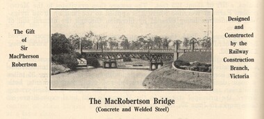
Image, MacRobertson's Bridge, 1934
Confectionery king MacPherson Robertson personally funded the £19 000 cost of the steel arch MacRobertson or Grange Road Bridge (1934) as a gift to Victoria for its centenary. (http://www.emelbourne.net.au/biogs/EM00234b.htm)A steel bridge over the Yarra River, Melbourne. The bridge was funded by MacPherson Robertson.macrobertson, bridge -
 Hume City Civic Collection
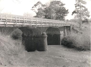
Photograph, Early 1970s
The Macedon Street Bridge over Jacksons Creek is important because it was built on one of Victoria's first important roads. It replaced a smaller lighter bridge in 1857 and continued to be used until the early 1970s.A black and white photograph of a two arched bluestone bridge over a creek. A wooden post and rail fence painted white has been constructed in front of the original stone wall of the bridge.bridges, bluestone bridges, jacksons creek, macedon street, george evans collection -
 Clunes Museum
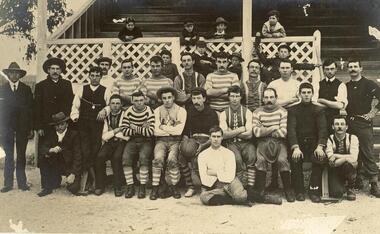
Photograph, VICTA STUDIOS, CLUNES
POST CARD ADDRESSED TO MISS MAY HUDSON, CLUNES. SHE WAS A DAUGHTER OF LAURA HUDSON. POSTCARD FOUND IN THE HOME OF THE LATE LAURA HUDSON, LOWER FRASER STREET, CLUNES [NOW BLACKMORE ROAD]BLACK & WHITE POSTCARD OF A GROUP OF SPORTSMEN, CHILDREN STANDING, A GRANDSTAND IN THE BACKGROUND.SEE OVERlocal history, photography, photographs, hudson, laura -
 The Adam Lindsay Gordon Commemorative Committee Inc.
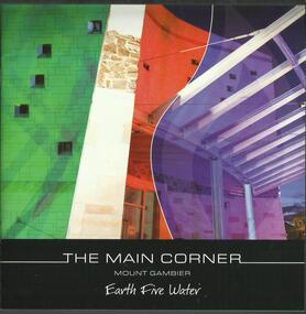
Booklet, The Main Corner, Mount Gambier : earth, fire, water, 2011
Information booklet about the new Main Corner complex located at 1 Bay Road, Mount Gambier. The building and surrounds offer the opportunity to learn about Mount Gambier's local history and culture.For two years he was stationed at Penola in the Mount Gambier region where he led a routine life with no remarkable incidents or exploits to interrupt his daily duties. (from Australian Dictionary of Biography: http://adb.anu.edu.au/biography/gordon-adam-lindsay-3635)22 pages booklet with colour illustrations. Front page depicting the entrance of the Main Corner in Mount Gambiermain corner, mount gambier, gretel sneath, adam lindsay gordon -
 Stawell Historical Society Inc
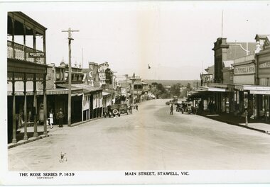
Photograph, Main Street Stawell looking west towards the Post Office Rose series 1639
This photograph is of Main Street Stawell lookingwest around c 1930's. The photo was taken from the Bull and Mouth Hotel whis is on the left side and other business. On the road are a few people and cars.Black and white Postcard Rose Series 1639 Looking down Main St From the Bull and Mouth Hotel Partially visable on the left. The Rose series, P 1639 Main Street, Stawell, Victoriastawell business shops streetscape -
 Rutherglen Historical Society
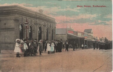
Image, F. Harrison, Main Street, Rutherglen, c1890
View is from the corner of Main and High Streets. On the corner is the bank that is now the NAB. Further along the road, with the gabled roof above the other buildings, is the Rutherglen Hotel while it was still a weatherboard building.Coloured postcard photograph, showing a view of Main Street Rutherglen with a group of people waiting to see the parade coming up the street.Printed on back of card: "Published by F. Harrison, Rutherglen"main street, parades, rutherglen hotel, banks -
 Ballarat Heritage Services
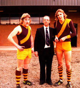
Photograph - digital copy, K.P. Gervasoni, North Kew Rovers footballers Peter Cooper and Niall McAllister with Mayor of Kew Cr Jack Gervasoni),1979, 1979
Jack and Kathleen Gervasoni ran the North Kew Authorised Newsagency at 93 Willsmere Road for 17 years. Peter Cooper and Niall McAllister where two of a multitude of paperboys who worked at the newsagency.Copy of colour photograph of two North Kew Rovers Footballers with City of Kew Mayor Cr John H. Gervasoni. Left to right: Peter Cooper, Jack Gervasoni, Niall McAllister at Stradbroke Park, Kewkew, gervasoni, jack gervasoni, mayor, team, sport, football, cooper, stradbroke park, peter cooper, neil mcalister, paperboys, j.h. gervasoni, niall mcalister -
 Kew Historical Society Inc
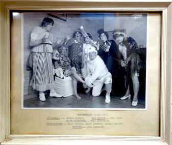
Photograph, Kew Elder Citizens' Club, Cast of 'Cinderella', Kew Elder Citizens' Association, 1976
The Kew Elder Citizen's Association was formally established in 1952. During its initial years it met at South Esk in Cotham Road. Later the Club moved to its current headquarters in High Street.Framed photograph of a theatrical performance of 'Cinderella' by the Kew Elder Citizens' Club in 1976. Handwritten insert below photograph: "Cinderella - Cast, 1976 / Arthur Sharpe; The Prince - Hec Camm; Fairy Godmother - Bill Humphries; Step-sisters - Wally Tustin, Ralph Preston, George Driver; Compere - Alma Westcott".kew elder citizens' club -- association, community groups -- kew (vic.), kew senior citizens, theatre -- kew (vic.)