Showing 123556 items matching "main-road"
-
 Stawell Historical Society Inc
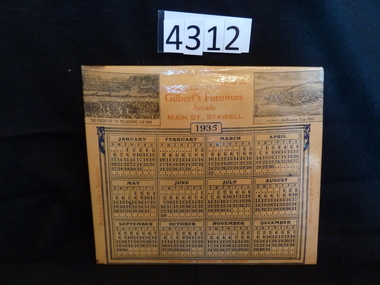
Memorabilia - Realia, 1935
1935 Advertising Calendar P. E. Gilbert. Gilberts Furniture Arcade Main Street Stawell. Shows Peter Pan winning the 1934 Melbourne Cup and Archer the 1862 Cupstawell -
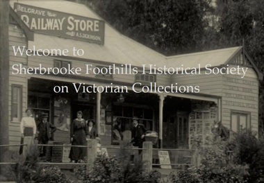 Sherbrooke Foothills Historical Society
Photograph, Welcome to Sherbrooke Foothills Historical society
Close up of A.S. Dickinson's "Railway Store " Main Street Belgrave. Features three women, two children, two men and a horse looking at the camera. Photograph by Charlie Hammond -
 Bendigo Historical Society Inc.
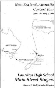
Document - CONCERT PROGRAMME
New Zealand- Australia Concert Tour'. April 15 - May 2, 1994. 'Los Altos High School Main Street Singers. Barrett E. Troll, Interim Director.event, entertainment, music, concert programme, new zealand - australia concert tour, los altos high school main street singers, barrett e troll -
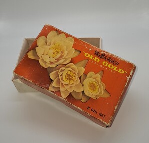 Glenelg Shire Council Cultural Collection
Functional object - Chocolate Box, 1900s
Oblong chocolate box. Lid has 3 flowers depicted on it. In the top right hand corner is, Mac Roberton's 'Old Gold Chocolates'. Main colour is orange. The base is white.Mac Robertson's / 'OLD GOLD' / Chocolates 8 Ozs.net Mac Robertson Pty LTD, Melbourne, Australiachocolate, confectionary, leisure, business -
 Clunes Museum
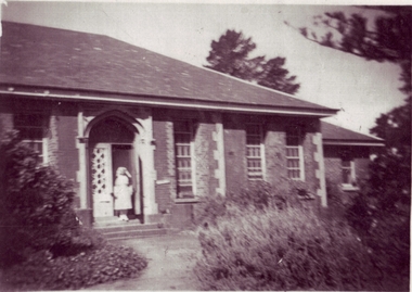
Photograph, CLUNES HOSPITAL
THE CLUNES HOSPITAL WAS RE-MODELLED IN 1937 - SUBSEQUENTLY BURNT IN A BUSHFIRE IN 1944. A NEW HOSPITAL WAS BUILT IN ANOTHER SITE IN 1947.LARGE PHOTOCOPY OF CLUNES HOSPITAL WHICH WAS BURNT DURING THE 1944 BUSH FIRES. MATRON CLAIRE STEWART STANDING ON FRONT STEPS OF MAIN ENTRANCE. NURSES ROOMS ON RIGHT SIDE.local history, photography, photographs, hospital [old] -
 Glenelg Shire Council Cultural Collection
Photograph - Photograph - Blacknose Quarry, 03/02/1954
Port of Portland Authority ArchivesBack: Purple PHT stamp -
 Halls Gap & Grampians Historical Society
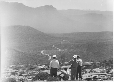
Photograph - B/W
Photo shows construction workers looking over valley with rough formation of Mt William road. There are 4 men in photo, 2 wearing hard-hats. There appears to be 2 vehicles on the road.WMT Mt William construction 1966-68access routes, roads, access routes, mt william road -
 Halls Gap & Grampians Historical Society
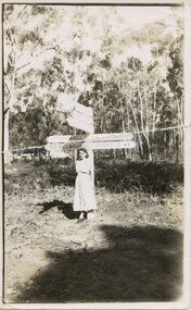
Photograph - B/W, C 1950s (?)
The woman is Mrs. Ron Groves, formerly Dulcie Stevenson, Cheltenham.The photo shows a woman standing in front of road signs at a road junction. The visible signs read "17 Stawell" and "163 Melbourne" to the left and "Halls Gap 1" and "Dunkeld 49" to the right.people, tourists -
 Federation University Historical Collection
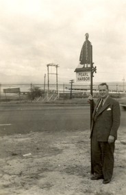
Photograph - black and white, Frank Wright at Pearl Harbor, mid 1900's
Frank Wright was a renown resident of Smeaton, where he was born on 2 August 1901. He lived at Laura Villa, and attended Smeaton State School. His father William was a gold miner and his mother's name was Sarah. Their family won many singing and instrumental awards. Frank was tutored by Percy Code and was awarded a gold medal for the highest marks in the ALCM examinations in the British Colonies at the age of seventeen years. He became the Australian Open Cornet Champion by the age of eighteen. A year later, Frank conducted the City of Ballarat Band, and later the Ballarat Soldiers’ Memorial Band. He formed the Frank Wright Frisco Band and Frank Wright and his Coliseum Orchestra. These bands won many South Street awards, and Frank as conductor won many awards in the Australian Band Championship contest. In 1933 Frank Wright sailed to England to conduct the famous St Hilda’s Band and was later appointed Musical Director of the London County Council, where he organized many amazing concerts in parks, in and around the London district. He was made Professor of Brass and Military Band Scoring and conducted at the Guildhall of Music and Drama. Frank was often invited to adjudicate Brass Band Championships around Europe, in Australia, including South Street and in New Zealand. The Frank Wright Medal at the Royal South Street competition is awarded to an individual recognized as making an outstanding contribution to brass music in Australia.Black and white photograph of a man dressed in a suit, standing beside the road and holding onto a signpost saying Pearl Harbor. On the other side of the road in the distance can be seen buildings and water.frank wright, conductor, pearl harbor -
Whitehorse Historical Society Inc.
Newspaper, Kinder Crisis Is Ignored, 21/10/1976 12:00:00 AM
Nunawading Council refuses request for Council owned Hall on Corner of Canterbury and Holland Roads, Blackburn, to be used as Kindergarten for Holland Road Pre-School,Nunawading Council refuses request for Council owned Hall on Corner of Canterbury and Holland Roads, Blackburn, to be used as Kindergarten for Holland Road Pre-School, which is to lose its current premises.Nunawading Council refuses request for Council owned Hall on Corner of Canterbury and Holland Roads, Blackburn, to be used as Kindergarten for Holland Road Pre-School,preschools, canterbury road, blackburn south, holland road preschool, city of nunawading, holland road -
Whitehorse Historical Society Inc.
Map, Mitcham, 1880s?
Hand drawn map of area north and south of Whitehorse Road and South of Canterbury Road c.1880-1900.Hand drawn map of area north and south of Whitehorse Road and South of Canterbury Road c.1880-1900. Probably sketched by a McClare descendant. Includes locations and names of settlers of that time.Hand drawn map of area north and south of Whitehorse Road and South of Canterbury Road c.1880-1900. whitehorse road, mitcham, mitcham road, mitcham, l l vale road, vermont, canterbury road, mitcham -
 Whitehorse Historical Society Inc.
Photograph, Springvale & Springfield Roads Corner, Nunawading, 2000
Produced as one of a series of 24 prints commissioned by Nunawading & District Historical Society -|Theme: Intersections of Mitcham and Nunawading 2000/2001.|See also Series by P. Simmenauer on the same theme.Black and white photograph - print and negative looking towards Corner of Springfield Road, Nunawading and Springvale Road. Also in view All Saints Anglican Church circa 1970's building.springvale road nunawading, all saints anglican church, nunawading -
 Whitehorse Historical Society Inc.
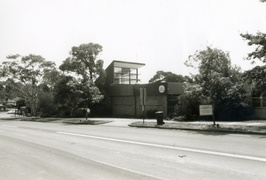
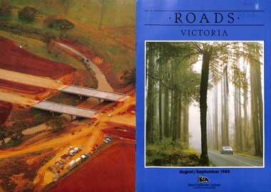
Pamphlet, Roads, 1985
Issue of Roads Victoria August / September 1985 containing 'An Outline history of Victoria's early roads: the Gold Rush era, 1851 - 56 by Peter F.B. Alsop p. 4 - 6.roads and streets, alsop, peter f. b. -
 Whitehorse Historical Society Inc.
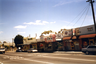
Photograph, Nunawading Shopping Centre, 1998
Coloured photograph of the Nunawading Shopping Centre on the left of Springvale Road just before the Whitehorse Road intersection. Old hall with white roof can be seen behind the wine shop on the left.nunawading shopping centre -
 Ballarat Tramway Museum
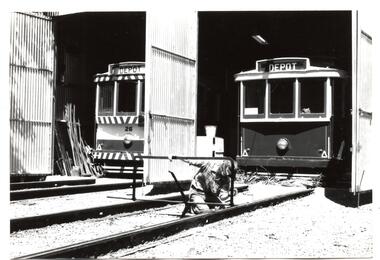
Photograph - Black & White Photograph/s, Richard Gilbert, c1976
Black and white photograph of Graeme Jordan painting a life guard bracket, possibly for No. 28. The tram is behind on No. 2 road and No. 26 on 3 road. Printed on Kodak Paper. Photo c1976. trams, tramways, btps, depot, tram 28, tram 26 -
 Kew Historical Society Inc
Photograph - Flooding of the Yarra Valley at Kew East, 1974
Flooding of the Yarra Valley, including that section of the Yarra bordering Kew and Kew East in the north and west of the municipality, was a regular occurrence. Extreme flood events of the Yarra River are recorded to have occurred in 1891, 1901, 1916, 1923 and 1934. The Municipality of Kew's response to these floods was to enact planning decisions restricting residential development in flood prone areas following the floods of 1916, 1921 and 1934. While floods continued after the development of the Upper Yarra Reservoir (construction 1948-57), the regularity and extent of these inundations diminished. During the nineteenth century, the land abutting the south side of the Yarra in Kew was devoted to dairy farming. In the twentieth century, before and after the construction of the Eastern Freeway, much of this low-lying area was used as golf courses and public parks.Late example of the capacity of the Yarra Valley at Kew to flood, even though drainage works and the Upper Yarra Reservoir had reduced their regularity.Original black and white print photograph of the low-lying land at East Kew under floodwater on 16 May 1974. The vantage point of the photographer is at Willsmere Road. The road itself is underwater.Annotation verso: "Willsmere Rd / Same as No.7 / 16 May 1974 11.15am"floods, yarra river, willsmere road -
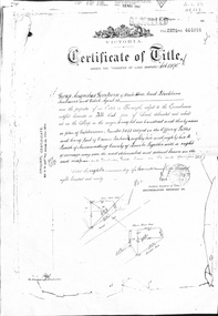 Whitehorse Historical Society Inc.
Document - Land Title, Certificate of title, 08/11/1890
Certificate of Title issued to George Augustus Goodwin in 1890 for land between Whitehorse Road and Railway Road, Blackburn together with records of transfers to 1946, the last being to Cottee's Passiona Limited.goodwin, george augustus, shelmerdine, thomas, chrystine, heather blanche, parkinson, basil john, dennis, alexander tregwitha, cottees factory, land sales -
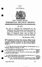 Melbourne Tram Museum
Legal record, Victorian Government, "Act of Parliament", 1/12/1978 12:00:00 AM
Act of the Victorian Parliament to authorize the construction by the MMTB of an electric tramway in the City of Preston and the Shire of Diamond Valley and the Shire of Whittlesea in Plenty Road, to Settlement Road. Dated 5/12/1978trams, tramways, mmtb, acts of parliament, new tramway, east preston, plenty rd, construction -
Canterbury History Group
Photograph - New Theatre, Maling Road Canterbury, Jan Pigot, 1/03/1990 12:00:00 AM
Remains of the New Theatre, Maling Road Canterbury burnt down March 11 1990, looking west from the side door and the glass area looking at the inside of the Maling Road wallcanterbury, maling road, theatres, new theatre -
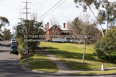 Eltham District Historical Society Inc
Photograph, Peter Pidgeon, Eltham Primary School, Dalton Street, Eltham, 2 Aug. 2022
View looking up Dalton Street from near Main Road where the former pond was situated. The pond was drained by Council in 1932 due to concerns of mosquitoes, etc against the wishes of long standing residents such as Thekla Jarrold (39 years) and John Clark (22 years). On the right is the Eltham Primary Schoool No. 209 with the former Headmaster's residence.Born Digitaleltham, dalton street, main road, eltham primary school, headmaster's residence, state school no. 209 -
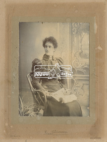 Eltham District Historical Society Inc
Photograph, E. Strawbridge, Caroline Shillinglaw (1876-1956), c.1896
Caroline (Carrie) Shillinglaw was the third child of Phillip and Sarah Shillinglaw, born 29 February 1876 in Bundoora. She commenced school at Eltham State School No. 209 in Dalton Street in April 1882. She married Christopher Watson on 23 Oct. 1907. Christopher Watson was the owner of Watson's Hotel on the corner of Pitt Street and Maria Street (Main Road).E. Strawbridge 129 Park St. Parkville Melbournecaroline shillinglaw, caroline watson (nee shillinglaw), caroline (carrie) watson (nee shillinglaw 1876-1956), carrie shillinglaw -
 Bendigo Historical Society Inc.
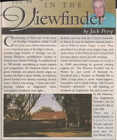
Newspaper - JACK PERRY COLLECTION: NEWSPAPER FOUNDRIES
Newspaper article discussing Harkness, Roberts & Son United Ironworks, Myers St later in Wills St where Target is now, Carter and Brown, Creek St., Phoenix foundry in Wattle St., Horsfield in Havilah Road, Central Foundry Eaglehawk Road ( Osborne's ) Eaglehawk Foundry, Caldwell's Road, Jobs Hill.bendigo, mining, harkness foundry -
 Bendigo Historical Society Inc.
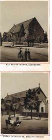
Photograph - ALL SAINTS CHURCH / ST KILLIAN'S CHURCH
Black and White Photos taken from the 'Album of Sandhurst Views', Published by Mossrs Schutz & Co, Melbourne, All Saint's Church. Three people standing on road. Sandhurst, Roman Catholic St Killian's Church. man with horse and cart passing on the road. Four people on footpath. One on road near cart.organization, church, bendigo churches, all saints church, st killian's church, churches, sandhurst churches -
 Kew Historical Society Inc
Plan - Subdivision Plan, J R Mathers & McMillan, Myrtle Hill Estate, East Kew, circa 1949, c.1949
The Kew Historical Society's map collection includes a substantial number of real estate subdivision plans, mainly of Kew but also of surrounding suburbs in Melbourne. Most of the subdivision plans date from the 1920s and 1930s when the districts old homes and local farmland were being split up to accommodate residential growth in the postwar period. These early plans were assembled by a local firm, Jas R Mather & McMillan, which had an office in Cotham Road. Many of the plans, and sometimes photos, were annotated by the agents.Subdivision plans are historically important documents used as evidence for the growth of suburbs in Australia. They frequently provide information about when the land was sold as well as evidence relating to surveyors and real estate and financial agents. The numerous subdivision plans in the Kew Historical Society's collection represent working documents, ranging from the initial sketches made in planning a subdivision to printed plans on which auctioneers or agents listed the prices for which individual lots were sold. In a number of cases, the reverse of a subdivision plan in the collection includes a photograph of a house that was also for sale by the agent. These photographs provide significant heritage information relating house design and decoration, fencing and household gardens.The photograph may also be aesthetically significant depending on the importance of the photographic atelier.Myrtle Hill, at 14 Vista Avenue, Kew, is of local historical and architectural significance as a good example of a large and imposing single-storey Italianate house of the early 1870s surviving in Kew. Originally sited on a large allotment overlooking Normanby Road, the setting of the house has been dramatically altered through extensive subdivision and development. The subdivision plan of the ‘Myrtle Hill Estate’ indicates that in one such subdivision, 11 allotments were created fronting Bowyer Avenue, Myrtle Avenue, and Normanby Road. The outline and building profile of Myrtle Hill is shown on the west side of Bowyer Avenue.The full (typed) title of this subdivision plan is :"Plan of SUBDIVISION of part of CROWN PORTION 83. / at KEW / PARISH OF BOROONDARA. / COUNTY OF BOURKE". / "MYRTLE HILL ESTATE / EAST KEW" In addition to the Title and subtitle, the plan also lists the advantages of the subdivision. -
 Kiewa Valley Historical Society
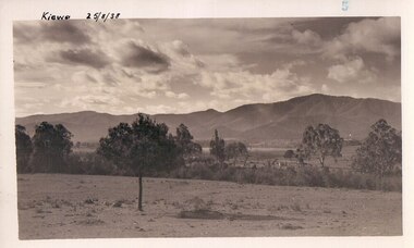
Black and white photograph of farmland, Kiewa, 25/8/38, circa 1938
This photograph was taken in August, 1938 some eight years prior to the establishment of Mt. Beauty as a township. The area was still being used for grazing, and the land was eventually acquired from the local land owners by the State Electricity Commission. The construction of the road, from Tawonga to the High Plains, was commenced in April of this year. This allowed men and heavy equipment to be transported to the work sites for the construction of the Kiewa Hydro Electric Scheme This photograph is important as it shows the upper Kiewa Valley as it was before the establishment of the town of Mt. Beauty. The land has been cleared of natural growth and has been used for grazing cattle. By 1946 housing construction had commenced for the new town of Mt. Beauty and by 1948 street construction in the southern part of the town was completed as far as Hill Street.A black and white photograph of farmland with Mt. Emu in the background. This has been taken from where Mt. Beauty township now stands prior to road making and the erection of houses. A line of trees below the hill line indicates the position of the East Kiewa River. (No. 5 in a set of 8) Handwritten in black ink on the upper left corner of the photograph is the inscription 'Kiewa 25/8/38' and the number 5 has been stamped on the upper right hand corner. On the back is the word 'Velox' which is the name of the photographic paper on which the photo was developed.road construction, kiewa, tawonga, mt. beauty, secv -
Whitehorse Historical Society Inc.
Document, Eastern Freeway Extension, 2000 - 2002
Eastern Freeway ExtensionEastern Freeway Extension- Cost estimates for community consultation option Public consultation process : report on analysis submissions Deep Creek Road - Landscape concept Media Release from Premier of Victoria VicRoads - Works update newsletters Whitehorse City Council minutes VicRoads Correspondence Schwerkolt Cottage Precinct - Concept Plan VicRoads maps.Eastern Freeway Extensioneastern freeway extension, vicroads, victoria. department of infrastructure, city of whitehorse, schwerkolt cottage, landscape planning, maps -
 Kew Historical Society Inc
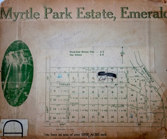
Plan - Subdivision Plan, Myrtle Park Estate, Emerald, 1915
This subdivision plan for the ‘Myrtle Park Estate’ relates to land sales in Emerald, Victoria, rather than to the subdivision of the same name in East Kew (1913-16). The subdivision in Emerald included 32 one-acre lots facing Torley Road, Government Road (now Rawhiti and Wong Hee Roads) Beaconsfield Road (now Old Beaconsfield Road). On the plan, an unnamed creek flows through allotments 8-12 on the east side of the Estate. The photograph of a waterfall and the advertised price of Day Return and Weekend Return Fares provide an indication of who the prospective purchasers were likely to be.subdivision plans - emerald, myrtle park estate, torley road -- emerald (vic.) -
Surrey Hills Historical Society Collection
Postcard - Union Road, Surrey Hills looking north
Surrey Family Hotel (McNeill's Family Hotel) was built in 1888 by Alexander McNeill. It closed as a hotel after the Local Option vote in 1920.A colour post card from a watercolour sketch of the intersection of Union and Canterbury Roads looking north towards Mont Albert Road. It shows bluestone guttering edging the road in the foreground. Children are gathered under the verandah on the SW corner of the intersection and on the road. A horse drawn vehicle is seen travelling to the west down Canterbury Road. McNeill's Family Hotel, the Surrey Hall and part of Hansen's Terrace can be seen. Advertising signs for Otto Preuss (undertaker) and A R B Cuest (baker) can be partly seen. In the distance scattered houses and open space can be seen.Front: Printed on the post card "Union Rd. Surrey Hills, looking North" Rear: "BOX HILL HISTORICAL SOCIETY" (stamp) and "Mrs E W Zerbe / Williamson Rd. / Doncaster" in biro. This is possibly Marjorie Morgan's writing. "POST WTP (within cartouche) CARD" and "Printed / in / Germany" printed on card.mcneill's family hotel, bakers, undertakers, surrey hall, surrey theatre, rex theatre, mr a r b cuest, mr otto preuss -
 Flagstaff Hill Maritime Museum and Village
Newspaper - Newspaper clipping, 22-03-1947
Newspaper clippings and a typed sheet regarding shipwrecks in South West Victoria. (1) The first clipping is titled Wrecks of the Last Half Century, page 12 of the Warrnambool Centenary Supplement, The Warrnambool Standard, Saturday, March 22, 1947. The ships mentioned are FREE TRADER, LA BELLA, FALLS OF HALLADALE, CASINO and CARAMBA. (2) The second clipping's main article Divers Find old shipwreck from Geoff Clancy has a handwritten date Circa Jan 30, 1960, and is possibly from a Melbourne newspaper, as it mentions non-local events. It tells of the then-current finding of the 52-year-old wreck of the Falls of Halladale near Port Campbell by skin divers. (3) Type is written 2-page article The Romance of the Clipper Ships by Basil Lubbock sub-title Falls of Halladale. The iron-hulled, four-masted barque, the Falls of Halladale, was a bulk carrier of general cargo. She left New York in August 1908 on her way to Melbourne and Sydney. In her hold, along with 56,763 tiles of unusual beautiful green American slates (roofing tiles), 5,673 coils of barbed wire, 600 stoves, 500 sewing machines, 6500 gallons of oil, 14400 gallons of benzene, and many other manufactured items, were 117 cases of crockery and glassware. Three months later and close to her destination, a navigational error caused the Falls of Halladale to be wrecked on a reef off the Peterborough headland at 3 am on the morning of the 15th of November, 1908. The captain and 29 crew members all survived, but her valuable cargo was largely lost, despite two salvage attempts in 1908-09 and 1910. ABOUT THE ‘FALLS OF HALLADALE’ (1886 - 1908): - Built: in1886 by Russell & Co., Greenock shipyards, River Clyde, Scotland, UK. The company was founded in 1870 (or 1873) as a partnership between Joseph Russell (1834-1917), Anderson Rodger and William Todd Lithgow. During the period 1882-92 Russell & Co. they standardised designs, which sped up their building process so much that they were able to build 271 ships over that time. In 1886 they introduced a 3000 ton class of sailing vessel with auxiliary engines and brace halyard winches. In 1890 they broke the world output record. Owner: Falls Line, Wright, Breakenridge & Co, 111 Union Street, Glasgow, Scotland. Configuration: Four masted sailing ship; iron-hulled barque; iron masts, wire rigging, fore & aft lifting bridges. Size: Length 83.87m x Breadth 12.6m x Depth 7.23m, Gross tonnage 2085 ton Wrecked: the night of 14th November 1908, Curdies Inlet, Peterborough south west Victoria Crew: 29 The Falls of Halladale was a four-masted sailing ship built-in 1886 in Glasgow, Scotland, for the long-distance cargo trade and was mostly used for Pacific grain trade. She was owned by Wright, Breakenridge & Co of Glasgow and was one of several Falls Line ships, all of which were named after waterfalls in Scotland. The lines flag was of red, blue and white vertical stripes. The Falls of Halladale had a sturdy construction built to carry maximum cargo and able to maintain full sail in heavy gales, one of the last of the ‘windjammers’ that sailed the Trade Route. She and her sister ship, the Falls of Garry, were the first ships in the world to include fore and aft lifting bridges. Previous to this, heavily loaded vessels could have heavy seas break along the full length of the deck, causing serious injury or even death to those on deck. The new, raised catwalk-type decking allowed the crew to move above the deck stormy conditions. This idea is still used today in the most modern tankers and cargo vessels and has proved to be an important step forward in the safety of men at sea. On 4th August 1908, with new sails, 29 crew, and 2800 tons of cargo, the Falls of Halladale left New York, bound for Melbourne and Sydney via the Cape of Good Hope. The cargo on board was valued at £35,000 and included 56,763 tiles of American slate roofing tiles (roof slates), 5,673 coils of barbed wire, 600 stoves, 500 sewing machines, 6,500 gallons of oil, 14,400 gallons of benzene, plumbing iron, 117 cases of crockery and glassware and many other manufactured items. The Falls of Halladale had been at sail for 102 days when, at 3 am on the night of 14th November 1908, under full sail in calm seas with a six knots breeze behind and misleading fog along the coast, the great vessel rose upon an ocean swell and settled on top of a submerged reef near Peterborough on south-west Victoria’s coast. The ship was jammed on the rocks and began filling with water. The crew launched the two lifeboats and all 29 crew landed safely on the beach over 4 miles away at the Bay of Islands. The postmistress at Peterborough, who kept a watch for vessels in distress, saw the stranding and sent out an alert to the local people. A rescue party went to the aid of the sailors and the Port Campbell rocket crew was dispatched, but the crew had all managed to reach shore safely by the time help arrived. The ship stayed in full sail on the rocky shelf for nearly two months, attracting hundreds of sightseers who watched her slowly disintegrate until the pounding seas and dynamiting by salvagers finally broke her back, and her remains disappeared back into deeper water. The valuable cargo was largely lost, despite two salvage attempts in 1908-09 and 1910. Further salvage operations were made from 1974-1986, during which time 22,000 slate tiles were recovered with the help of 14 oil drums to float them, plus personal artefacts, ship fittings, reams of paper and other items. The Court of Marine Inquiry in Melbourne ruled that the foundering of the ship was entirely due to Captain David Wood Thomson’s navigational error, not too technical failure of the Clyde-built ship. The shipwreck is a popular site for divers, about 300m offshore and in 3 – 15m of water. Some of the original cargo can be seen at the site, including pieces of roof slate and coils of barbed wire.The newspaper articles are of historical significance, retelling the stories of shipwrecks along the South West coast of Victoria. The Falls of Halladale shipwreck is listed on the Victorian Heritage Register (No. S255). She was one of the last ships to sail the Trade Routes. She is one of the first vessels to have fore and aft lifting bridges. She is an example of the remains of an International Cargo Ship and also represents aspects of Victoria’s shipping industry. The wreck is protected as a Historic Shipwreck under the Commonwealth Historic Shipwrecks Act (1976).Newspaper cuttings with text and photographs (3) relevant to Falls of Halladale, La Bella, Casino, Free Trader and the refurbishing of the Falls of Clyde. Also included is typewritten information about Falls of Halladale. Printed between 1947 and 1972 in Melbourne, Victoria Author of the typed article "The Romance of the Clipper Ships" was Basil Lubbock Handwritten on article "Circa: JAN 30 1960" Headline "Divers find old shipwreck" "Geoff Clancy" "Not salvaged" "Still wedged" "Falls of Halladale" Typed pages: "THE ROMANCE OF THE CLIPPER SHIPS BY BASIL LUBBOCK" "FALLS OF HALLADALE" flagstaff hill, warrnambool, shipwrecked-coast, flagstaff-hill, flagstaff-hill-maritime-museum, maritime-museum, shipwreck-coast, flagstaff-hill-maritime-village, falls of halladale, la bella, falls of clyde, freetrader, casino, coramba, geoff clancy, warrnambool standard january 30 1947, warrnambool centenary supplement 1947, wrecks of the last half century, newspaper article divers find by geoff clancy, the romance of the clipper ships by basil lubbock, free trader, speculant, clipper ship, shipwrecks -
 Flagstaff Hill Maritime Museum and Village
Calendar, T.S. McInnes, August 1923
HISTORY OF THE LOCH ARD The LOCH ARD belonged to the famous Loch Line which sailed many ships from England to Australia. Built in Glasgow by Barclay, Curdle and Co. in 1873, the LOCH ARD was a three-masted square rigged iron sailing ship. The ship measured 262ft 7" (79.87m) in length, 38ft (11.58m) in width, 23ft (7m) in depth and had a gross tonnage of 1693 tons. The LOCH ARD's main mast measured a massive 150ft (45.7m) in height. LOCH ARD made three trips to Australia and one trip to Calcutta before its final voyage. LOCH ARD left England on March 2, 1878, under the command of Captain Gibbs, a newly married, 29 year old. She was bound for Melbourne with a crew of 37, plus 17 passengers and a load of cargo. The general cargo reflected the affluence of Melbourne at the time. On board were straw hats, umbrella, perfumes, clay pipes, pianos, clocks, confectionary, linen and candles, as well as a heavier load of railway irons, cement, lead and copper. There were items included that intended for display in the Melbourne International Exhibition in 1880. The voyage to Port Phillip was long but uneventful. At 3am on June 1, 1878, Captain Gibbs was expecting to see land and the passengers were becoming excited as they prepared to view their new homeland in the early morning. But LOCH ARD was running into a fog which greatly reduced visibility. Captain Gibbs was becoming anxious as there was no sign of land or the Cape Otway lighthouse. At 4am the fog lifted. A man aloft announced that he could see breakers. The sheer cliffs of Victoria's west coast came into view, and Captain Gibbs realised that the ship was much closer to them than expected. He ordered as much sail to be set as time would permit and then attempted to steer the vessel out to sea. On coming head on into the wind, the ship lost momentum, the sails fell limp and LOCH ARD's bow swung back. Gibbs then ordered the anchors to be released in an attempt to hold its position. The anchors sank some 50 fathoms - but did not hold. By this time LOCH ARD was among the breakers and the tall cliffs of Mutton Bird Island rose behind the ship. Just half a mile from the coast, the ship's bow was suddenly pulled around by the anchor. The captain tried to tack out to sea, but the ship struck a reef at the base of Mutton Bird Island, near Port Campbell. Waves broke over the ship and the top deck was loosened from the hull. The masts and rigging came crashing down knocking passengers and crew overboard. When a lifeboat was finally launched, it crashed into the side of LOCH ARD and capsized. Tom Pearce, who had launched the boat, managed to cling to its overturned hull and shelter beneath it. He drifted out to sea and then on the flood tide came into what is now known as LOCH ARD Gorge. He swam to shore, bruised and dazed, and found a cave in which to shelter. Some of the crew stayed below deck to shelter from the falling rigging but drowned when the ship slipped off the reef into deeper water. Eva Carmichael had raced onto deck to find out what was happening only to be confronted by towering cliffs looming above the stricken ship. In all the chaos, Captain Gibbs grabbed Eva and said, "If you are saved Eva, let my dear wife know that I died like a sailor". That was the last Eva Carmichael saw of the captain. She was swept off the ship by a huge wave. Eva saw Tom Pearce on a small rocky beach and yelled to attract his attention. He dived in and swam to the exhausted woman and dragged her to shore. He took her to the cave and broke open case of brandy which had washed up on the beach. He opened a bottle to revive the unconscious woman. A few hours later Tom scaled a cliff in search of help. He followed hoof prints and came by chance upon two men from nearby Glenample Station three and a half miles away. In a state of exhaustion, he told the men of the tragedy. Tom returned to the gorge while the two men rode back to the station to get help. By the time they reached LOCH ARD Gorge, it was cold and dark. The two shipwreck survivors were taken to Glenample Station to recover. Eva stayed at the station for six weeks before returning to Ireland, this time by steamship. In Melbourne, Tom Pearce received a hero's welcome. He was presented with the first gold medal of the Royal Humane Society of Victoria and a £1000 cheque from the Victorian Government. Concerts were performed to honour the young man's bravery and to raise money for those who lost family in the LOCH ARD disaster. Of the 54 crew members and passengers on board, only two survived: the apprentice, Tom Pearce and the young woman passenger, Eva Carmichael, who lost all of her family in the tragedy. Ten days after the LOCH ARD tragedy, salvage rights to the wreck were sold at auction for £2,120. Cargo valued at £3,000 was salvaged and placed on the beach, but most washed back into the sea when another storm developed. The wreck of LOCH ARD still lies at the base of Mutton Bird Island. Much of the cargo has now been salvaged and some was washed up into what is now known as LOCH ARD Gorge. Cargo and artefacts have also been illegally salvaged over many years before protective legislation was introduced. One of the most unlikely pieces of cargo to have survived the shipwreck was a Minton porcelain peacock - one of only nine in the world. The peacock was destined for the Melbourne International Exhibition in 1880. It had been well packed, which gave it adequate protection during the violent storm. Today, the Minton peacock can be seen at the Flagstaff Hill Maritime Museum in Warrnambool. From Australia's most dramatic shipwreck it has now become Australia's most valuable shipwreck artefact and is one of very few 'objects' on the Victorian State Heritage Register. Flagstaff Hill’s collection of artefacts from LOCH ARD is significant for being one of the largest collections of artefacts from this shipwreck in Victoria. It is significant for its association with the shipwreck, which is on the Victorian Heritage Register (VHR S417). The collection is significant because of the relationship between the objects, as together they have a high potential to interpret the story of the LOCH ARD. The LOCH ARD collection is archaeologically significant as the remains of a large international passenger and cargo ship. The LOCH ARD collection is historically significant for representing aspects of Victoria’s shipping history and its potential to interpret sub-theme 1.5 of Victoria’s Framework of Historical Themes (living with natural processes). The collection is also historically significant for its association with the LOCH ARD, which was one of the worst and best known shipwrecks in Victoria’s history. Calendar printed by Terang Express for August 1923 with picture of Loch Ard Gorge and survivors of wreck and also story of the episode. flagstaff hill, warrnambool, shipwrecked coast, flagstaff hill maritime museum, maritime museum, shipwreck coast, flagstaff hill maritime village, great ocean road, loch line, loch ard, captain gibbs, eva carmichael, tom pearce, glenample station, mutton bird island, terang express, calendar, 1923, calendar 1923, printer, newspaper, loch ard gorge