Showing 113078 items
matching road
-
 Marysville & District Historical Society
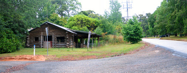
Photograph (Item) - Colour photograph, Travel Victoria, Unknown
A colour photograph of the Log Cabin that was situated on Pack Road in Marysville in Victoria.A colour photograph of the Log Cabin that was situated on Pack Road in Marysville in Victoria. This was a well known business in Marysville that sold tourist related items until it was destroyed in the 2009 Black Saturday bushfires.log cabin, marysville, pack road, victoria, 2009 black saturday bushfires, photograph -
 Marysville & District Historical Society
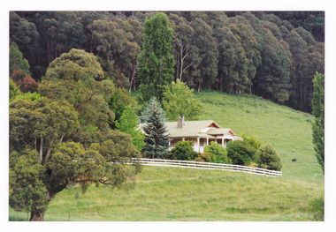
Photograph (Item) - Colour photograph, Unknown
A colour photograph of a house on the Marysville-Buxton Road near Marysville in Victoria.A colour photograph of a house on the Marysville-Buxton Road near Marysville in Victoria.marysville-buxton road, marysville, buxton, victoria, photograph -
 Marysville & District Historical Society
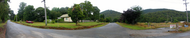
Photograph (Item) - Colour photograph, Unknown
A digital copy of a colour photograph taken in Racecourse Road in Marysville in Victoria.A digital copy of a colour photograph taken in Racecourse Road in Marysville in Victoria.racecourse road, marysville, victoria, photograph -
 Ringwood and District Historical Society
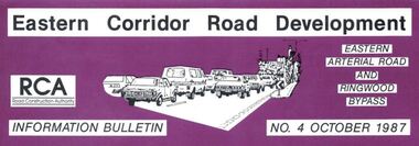
Newsletter, Eastern Arterial Road and Ringwood Bypass Information Bulletin - October 1987
Tri-fold A4 size brochure (6 pages) issued by Road Construction Authority reporting on specialist studies currently being undertaken for the Eastern Corridor Road Development investigations. Topics include Air Quality Study, Landscape and Recreation, Public Transport Study, Bypass Preferred Route, Long Term Access Strategy, Road Design. A government decision on the road development strategy proposal public exhibition commencing in November 1987 for 4 months could be made later in 1988. -
 Whitehorse Historical Society Inc.
Photograph, Whitehorse Road, Mitcham, 2000
Produced as one of a series of 24 prints commissioned by Nunawading & District Historical Society -|Theme: Intersections of Mitcham and Nunawading 2000/2001.|See also Series by P. Simmenauer on the same theme. Black and white photograph - print and negative looking East along North side of Whitehorse Road towards Mitcham Road intersection from corner of Station Street. Featured from L-R shops include Stan Russell Mens Clothing; Top floor Wing Chum Kung Fu Academy (Martial Art); Lower floor: Florist, Bryson Office Supplies, Mitcham Pharmacy and Medical Centre; Road sign - Mitcham Road - Vermont; across intersection - sign for 'Bristol Paints'.whitehorse road, mitcham, stan russell menswear, wing chum kung fu academy, florists, mitcham pharmacy, mitcham medical centre, bristol paints, bryson office supplies -
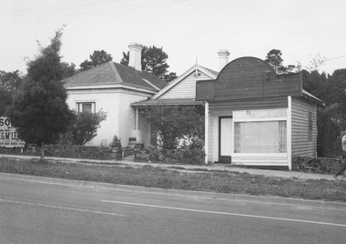
 Eltham District Historical Society Inc
Photograph, A.R. Warren's house, Main Road, Eltham
Black and photograph of A.R. Warren (Fuel Merchant) house, taken toward Main Road from northern rear side. Present day location of Le Pine Funerals, 848 Main Road, Eltham.a.r warren, main road, eltham, houses -
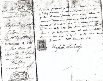 Whitehorse Historical Society Inc.
Document, Jobson's Road, 28/12/1895
Part of contract of sale between Elizabeth Salisbury (Vendor) and Eriksson (purchaser) of four acres of land with weatherboard house at Jobson's RoadPart of contract of sale between Elizabeth Salisbury (Vendor) and Eriksson (purchaser) of four acres of land with weatherboard house at Jobson's Road, Blackburn (now Junction Road, Blackburn North), 28 December 1895.Part of contract of sale between Elizabeth Salisbury (Vendor) and Eriksson (purchaser) of four acres of land with weatherboard house at Jobson's Roaderiksson, salisbury, elizabeth, jobson's road, blackburn, junction road, blackburn north, land sales -
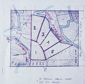 Eltham District Historical Society Inc
Slide - Photograph, Eltham Shire Council, Proposed subdivision of five approximately equal areas of 5 acres, Vol. 4061, Fol. 061, Overbank Road, North Warrandyte, 1969
35mm colour positive transparency blue Agfacolour Service plastic mountD4, 55341, Peck subdivision, Mount Pleasant Road, 4 August 1969infrastructure, map, planning, subdivison lots, overbank road, mount pleasant road, north warrandyte -
 Ringwood and District Historical Society
Photograph, Northward view over Mullum Creek bridge along Oban Road, Ringwood - 1981
Written on back of photograph, "1981 - Oban Road at bridge over Mullum Creek". -
 Ringwood and District Historical Society
Photograph, Mt. Dandenong Road, Ringwood. Klix's Tea Rooms. 1920s
Written on backing sheet, "Mt. Dandenong Road. Klix's Tea Rooms. 1920s". -
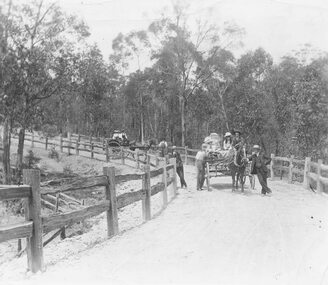 Ringwood and District Historical Society
Photograph, Horses and Carts on Road to Healesville? (undated)
Typed below one enlargement, "Road to Healesville?" and below the other, "Stopping for a chat". -
 Ringwood and District Historical Society
Photograph, Rear of Jack Williams' orchard, Mullum Road - 1964
Written on backing sheet, "Rear Jack Williams' orchard, Mullum Road - 1964". -
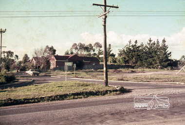
 Ringwood and District Historical Society
Photograph, From Wonga Road, overlooking Jack Aird's orchard. (undated)
Typed below photograph, "From Wonga Road, overlooking Jack Aird's orchard". -
 Ringwood and District Historical Society
Photograph, Army Depot, Dublin Road, Ringwood East, 1973
Written on backing sheet, "Army Depot, Dublin Road, Ringwood East, 1973". -
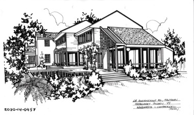
 Hawthorn Historical Society
Drawing - Property Illustration, 3/2 Kooyongkoot Road, Hawthorn
'After training as a Cartographic Draftsman within the mining industry, I worked as a property illustrator for real estate firms in the eastern suburbs of Melbourne for 23 years from 1983. I initially photographed houses with a Polaroid camera and made a 'thumbnail' sketch while there. The photos were used to scale off a sketch in pencil and then that sketch was overlaid with drafting film and the 'pen and ink' completed. The pens I used were the Rotring ‘Rapidigraph’ drafting pens. The ink was also made by Rotring (German).The film was ‘Rapidraw’, polyester drafting film, double matte. It takes a very fine line and doesn’t bleed. As well as house sketches, there were often floor plans and site plans ordered. Aerial sketches were ordered when the property needed an overall view.' (Margaret Picken, 2020)This property illustration is one of a series created by Margaret Picken for a range of real estate agents in Melbourne between c. 1983 and c. 2006. Each work is signed and dated by the artist.Gift of Margaret Picken, 2020pen and ink architectural drawing on drafting film.3/2 KOOYONGKOOT ROAD, HAWTHORN Margaret Picken ~92 WOODARDS - HAWTHORNartist - margaret picken 1950- -
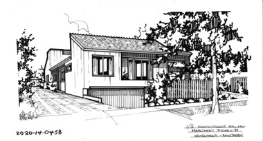
 Hawthorn Historical Society
Drawing - Property Illustration, 68 Kooyongkoot Road, Hawthorn (Rear)
'After training as a Cartographic Draftsman within the mining industry, I worked as a property illustrator for real estate firms in the eastern suburbs of Melbourne for 23 years from 1983. I initially photographed houses with a Polaroid camera and made a 'thumbnail' sketch while there. The photos were used to scale off a sketch in pencil and then that sketch was overlaid with drafting film and the 'pen and ink' completed. The pens I used were the Rotring ‘Rapidigraph’ drafting pens. The ink was also made by Rotring (German).The film was ‘Rapidraw’, polyester drafting film, double matte. It takes a very fine line and doesn’t bleed. As well as house sketches, there were often floor plans and site plans ordered. Aerial sketches were ordered when the property needed an overall view.' (Margaret Picken, 2020)This property illustration is one of a series created by Margaret Picken for a range of real estate agents in Melbourne between c. 1983 and c. 2006. Each work is signed and dated by the artist.Gift of Margaret Picken, 2020pen and ink architectural drawing on drafting film68 KOOYONGKOOT ROAD, HAWTHORN Margaret Picken ~92 WOODARDS - CAMBERWELL (REAR)artist - margaret picken 1950- -
 Hawthorn Historical Society
Drawing - Property Illustration, 1/76 Kooyongkoot Road, Hawthorn
'After training as a Cartographic Draftsman within the mining industry, I worked as a property illustrator for real estate firms in the eastern suburbs of Melbourne for 23 years from 1983. I initially photographed houses with a Polaroid camera and made a 'thumbnail' sketch while there. The photos were used to scale off a sketch in pencil and then that sketch was overlaid with drafting film and the 'pen and ink' completed. The pens I used were the Rotring ‘Rapidigraph’ drafting pens. The ink was also made by Rotring (German).The film was ‘Rapidraw’, polyester drafting film, double matte. It takes a very fine line and doesn’t bleed. As well as house sketches, there were often floor plans and site plans ordered. Aerial sketches were ordered when the property needed an overall view.' (Margaret Picken, 2020)This property illustration is one of a series created by Margaret Picken for a range of real estate agents in Melbourne between c. 1983 and c. 2006. Each work is signed and dated by the artist.Gift of Margaret Picken, 2020pen and ink architectural drawing on drafting film1/76 KOOYONGKOOT ROAD, HAW Margaret Picken ~88 WOODARDS - HAWTHORNartist - margaret picken 1950- -
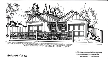 Hawthorn Historical Society
Drawing - Property Illustration, 99 A&B Manningtree Road, Hawthorn
'After training as a Cartographic Draftsman within the mining industry, I worked as a property illustrator for real estate firms in the eastern suburbs of Melbourne for 23 years from 1983. I initially photographed houses with a Polaroid camera and made a 'thumbnail' sketch while there. The photos were used to scale off a sketch in pencil and then that sketch was overlaid with drafting film and the 'pen and ink' completed. The pens I used were the Rotring ‘Rapidigraph’ drafting pens. The ink was also made by Rotring (German).The film was ‘Rapidraw’, polyester drafting film, double matte. It takes a very fine line and doesn’t bleed. As well as house sketches, there were often floor plans and site plans ordered. Aerial sketches were ordered when the property needed an overall view.' (Margaret Picken, 2020)This property illustration is one of a series created by Margaret Picken for a range of real estate agents in Melbourne between c. 1983 and c. 2006. Each work is signed and dated by the artist.Gift of Margaret Picken, 2020pen and ink architectural drawing on drafting film.99A&B MANNINGTREE ROAD, HAW Margaret Picken ~90 WOODARDS - HAWTHORNartist - margaret picken 1950- -
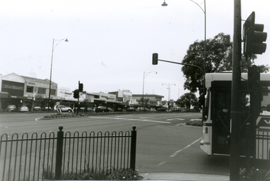
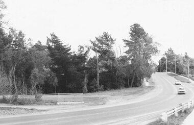
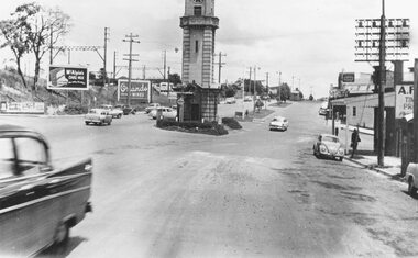 Ringwood and District Historical Society
Photograph, Maroondah Highway Central, Ringwood. Clock tower at intersection of Warrandyte Road and Highway, c1960's
Black and white photograph (2 copies)Nil Image shows Maroondah Highway looking west from Warrandyte Road. -
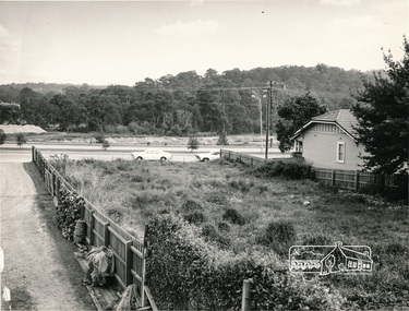
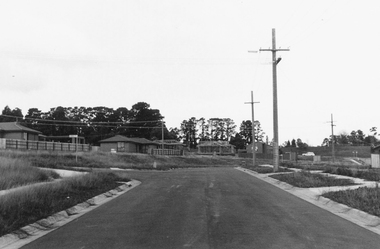 Ringwood and District Historical Society
Photograph, Southward view from the end of Jull Road, North Ringwood - 1981, later extended as Jull Parade
Written on back of photograph, "E621. N4. 1981. Jull Road, North Ringwood from its temporary end looking south towards the sports ground (on skyline). The white car is on Oban Road". -
 Eltham District Historical Society Inc
Slide, Site for the new Apex-Diamond Valley Ambulance Station, corner of Main Road and Looker Road, Montmorency, July 1969, 1969
Looking northwest from Main Road towards Looker Road at the new site for the Apex-Diamond Valley Ambulance Station before construction of Apex Way, July 1969. The Eltham Apex Club conducted a Community Service Project (1965-1968) to raise funds for a new Ambulance Station to service the community. A site bounded by the intersection of Main Road, Grand Boulevard and Looker Road at Montmorency was purchased in 1969. In 1970, Eltham Shire Council undertook roadworks to construct Apex Way in preparation for the new station as well as duplicate Main Road, Lower Plenty, east of Grand Boulevard including the new Lower Plenty Bridge, which had been opened in November 1966, bordering with the City of Heidelberg.35 mm colour positive transparency Mount - Agfacolor Service (Blue)1969-07, ambulance station, apex way, apex-diamond valley ambulance station, eltham ambulance station, looker road, lower plenty, main road, montmorency, eltham apex club -
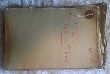 Melbourne Tram Museum
Document - Folder with papers, Public Works Department, "16/298 - Tramway Along Victoria St, Barkers Road and High Street to Burke Road", 1914 to 1916
Folder with papers or file with manila covers, secured with white cloth shoelace type retaining mechanism and red Bakelite type clips containing papers concerned with the construction of the tramway extension at Victoria Bridge (to run alongside the cable tram), the conversion of Kew Horse Tramway and construction of a new electric tramway to Burke Road - titled "16/298 - Tramway Along Victoria St, Barkers Road and High Street to Burke Road". Compiled by the Public Works Department of Victoria - generally dated 1914 to 1916 Shows the nature of the paperwork required for an Act of Parliament to authorise the work, orders in Council, drafts, actual copies of Parliamentary documents, letters to and from Councils, Members of Parliament, PMTT, plans, bridges and footpaths. Includes letters with the City of Collingwood, Kew and Richmond.trams, tramways, kew, high st, victoria st, bridges, collingwood, barkers rd, construction, cable trams, burke rd, pmtt, public works department, parliament -
 Eltham District Historical Society Inc
Photograph, Eucalyptus Road and Pitt Street/Nyora Road roundabout, Eltham
Looking north along Eucalyptus Road, showing roundabout at intersection of Pitt Street and Nyora Road, Eltham. Parks Victoria owns and manages the Pauline Toner Eltham Copper Butterfly Reserve on the left of the image. Colour photographeucalyptus road, pitt street, nyora road, roundabouts, eltham, pauline toner eltham copper butterfly reserve, pauline toner butterfly nature conservation reserve -
 Eltham District Historical Society Inc
Photograph, Eucalyptus Road and Pitt Street/Nyora Road roundabout, Eltham
Looking north along Eucalyptus Road, showing roundabout at intersection of Pitt Street and Nyora Road, Eltham. Parks Victoria owns and manages the Pauline Toner Eltham Copper Butterfly Reserve on the left of the image.Roll of 35mm colour negative film, 4 stripsFuji 100eltham, eucalyptus road, nyora road, pitt street, roundabouts, pauline toner eltham copper butterfly reserve, pauline toner buttefly nature conservation reserve -
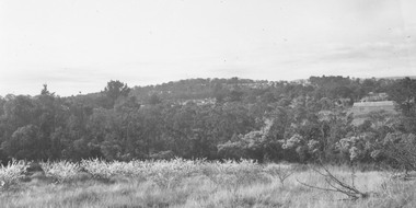
 Mt Dandenong & District Historical Society Inc.
Photograph, 1908 View of Kalorama Gap From the Main Road, 1908
View of the Kalorama Gap from main Road (now Ridge Road), looking across Walker's raspberry patch with Mountjoy coaching stables on the LHS and Mountjoy Guest House in centre. Price's house and shop on the RHS.mountjoy, walker, raspberry, coach, stables -
 Surrey Hills Historical Society Collection
Photograph, 87 Essex Road, c 1930 (demolished), 1930
A check of the electoral rolls points to this being the home of Frederick Harry Percival Lamble, labourer, born in Collingwood. He and his family continued to live at 87 Essex Road until his death in 1968 and his occupation is consistently given as labourer. His wife Bessie Louisa Woods died in 1957.Black and white photo taken from the street of an Edwardian style timber house with 2 chimneys, one of which looks like a kitchen or laundry chimney. The house stands behind a white wooden picket fence in a mature garden which conceals the bull-nose verandah. The house appears to have a slate roof with galvanised capping. To the left can be seen the roofs of houses in Durham Road.timber houses, edwardian style, essex road, lamble family, durham road, bessie ethel lamble, bessie ethel smith -
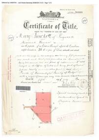 Ringwood and District Historical Society
Document, Certificate of Title - Mary Burchett, Lilydale Road, Ringwood - part of Crown Section 20, Parish of Warrandyte, County of Evelyn - 5th July, 1911
A4 copies of Landata Victoria Historical Search documents - Vol 3520 Fol 703990.Mary Burchett of Ringwood, Married Woman, is now the proprietor of an Estate in Fee-simple subject to the Encumbrances notified hereunder ... 50 acres 1 rood 32 perches or thereabouts, being lots 1 and 10 on plan of subdivision no.4315. Subdivision map includes un-named roads - western side is Wonga Road (later Warranwood Road), and eastern side is Grandview Grove (later Bemboka Road), both north of Plymouth Road, Ringwood, Vic. Title transferred to Theodore Hartley Burchett, 27th July, 1911. Encumbrance comment "Special railway condition contained in Grant to Francis Cooke." -
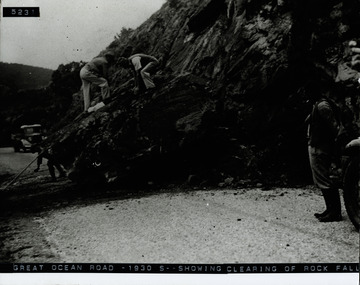 Lorne Historical Society
Photograph, Clearing Rockfall Great Ocean Road 1930's
Photograph showing clearing of rockfall on the Great Ocean Road, circa 1930'sg.o.r:; rockfall=-1930; -
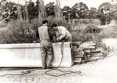 Eltham District Historical Society Inc
Photograph, Construction of Lower Plenty Bridge, Main Road, c.August 1966, 1966
Black and white photograph of construction of new bridge, Main Road, Lower Plentybridge construction, main road, lower plenty, plenty river, bridges -
 Eltham District Historical Society Inc
Photograph, Peter Bassett-Smith, Research Industrial Centre, Main Road, April 1988, 1988
Colour photograph showing the Research Industrial Centre, Main Road, April 1988main road, research vic.