Showing 2413 items
matching street parade
-
 Hume City Civic Collection
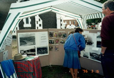
Photograph, Sunbury Fair, 16th March 1996
The people are looking at a photographic display mounted by the former members of the Sunbury & District Heritage Association. The event was the Sunbury Fair, which was staged on the Sunbury Village Green every year in March. A parade through the town took place in the morning and in the afternoon, community groups mounted displays on the Village Green. The Sunbury Fair was a popular community annual event that had wide support in the town.A coloured photograph of people looking at a display of photographs in an outdoor area.sunbury fair, sunbury & district heritage association, village green -
 Hume City Civic Collection
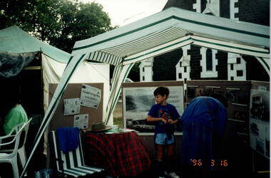
Photograph, Sunbury Fair, 16th March 1996
The people are looking at a photographic display mounted by the former members of the Sunbury & District Heritage Association. The event was the Sunbury Fair, which was staged on the Sunbury Village Green every year in March. A parade through the town took place in the morning and in the afternoon community groups mounted displays on the Village Green.The Sunbury Fair was a popular annual community event amongst the townspeople.A coloured photograph of people looking at a display of photographs in an outdoor area.sunbury fair, village green, sunbury & district heritage association -
 Lakes Entrance Regional Historical Society (operating as Lakes Entrance History Centre & Museum)
Photograph, Heather Bryant, 1/09/2002 12:00:00 AM
Colour photograph of LERHS members Marie Fish and Stella Rau after funeral of past member Glad Scarce at Braggs Funeral Chapel Main Street Bairnsdale Victoriafishing industry -
Lakes Entrance Regional Historical Society (operating as Lakes Entrance History Centre & Museum)
Photograph, Lakes Post Newspaper, 1/04/2008 12:00:00 AM
Colour photograph of Lakes Entrance Bowls Club President Linsay Wangman presenting LERHS President Marie Fish with cheque for $500 from the Wrong Bias account with Wendy Price and Trevor Jackson in photograph at Bowls Clubrooms Rowe Street Lakes Entrance Victoriahistorical society -
Lakes Entrance Regional Historical Society (operating as Lakes Entrance History Centre & Museum)
Photograph, Charles H Daniel, 1963
Charles Daniel and Charles Hancock Snr owned C.H. and D Credits Pty Ltd. In background Hillman car, Commer truck and Leyland Comet truckColour photograph taken during the construction of Hancock Engineering workshop with Brian, Charles Snr, Trevor, Charles Jnr Hancock standing in front of construction Carpenter Street Lakes Entrance Victoriapeople -
Lakes Entrance Regional Historical Society (operating as Lakes Entrance History Centre & Museum)
Photograph, 1995 c
Also another colour photograph of Miss Nancy Fraser standing in side garden at her unit on Rowe Stree 04863.1Colour photograph of Miss Nancy Hamilton Fraser standing beside the garden at her unit 2/6 Rowe Street Lakes Entrance Victoriafundraising, people -
Lakes Entrance Regional Historical Society (operating as Lakes Entrance History Centre & Museum)
Photograph, 1/05/1996 12:00:00 AM
Also a black and white photograph of Leann Edwards at an exhibition at Anchorage Coffee Lounge Myers Street Lakes EntranceBlack and white photograph at graphic design workshop of Leann Edwards Bronwyn Bancroft and Valetta Fentonaboriginals -
Lakes Entrance Regional Historical Society (operating as Lakes Entrance History Centre & Museum)
Photograph, Lakes Post Newspaper, 1/02/1996 12:00:00 AM
Black and white photograph showing Peter McGauren MHR unveiling a plaque to mark the opening of the Fishermens Gear Store with Peter Clark LEF Coop Board Chaiman Carpenter Street Lakes Entrance Victoriafishing industry -
Lakes Entrance Regional Historical Society (operating as Lakes Entrance History Centre & Museum)
Photograph, Lakes Post Newspaper, 1/09/1994 12:00:00 AM
Black and white of Holiday Concepts Riviera Beach Resort Rowe Street comprising seven self contained villas on timeshare concept Lakes Entrance Victoriatourism -
Lakes Entrance Regional Historical Society (operating as Lakes Entrance History Centre & Museum)
Photograph, M Holding, 1998
Colour photograph of work commencing on new Police Station corner of Roadknight and Myers Street with previous police Station on rear of the block Lakes Entrance Victoriapolice -
Lakes Entrance Regional Historical Society (operating as Lakes Entrance History Centre & Museum)
Postcard, Rose Stereograph Co Armidale Vic, 1940 c
Black and white postcard taken from Jemmys Point showing the Entrance, groynes at the entrance to North Arm and around Bullock Island and portion of New Works area. Two small boats moored in main channel Lakes Entrance Victoria P10722The Entrance Lakes Entrance Victoriafences, roads and streets, waterways -
Lakes Entrance Regional Historical Society (operating as Lakes Entrance History Centre & Museum)
Postcard
size 9 x 14 cmColour tinted postcard showing view of the entrance at Lakes EntranceThe Entrance Lakes Entrance Victoriafences, roads and streets -
Lakes Entrance Regional Historical Society (operating as Lakes Entrance History Centre & Museum)
Postcard, H D Bulmer, 1950 c
Also a cut down colour photograph of second humpy bridge to Bullock Island donated by M Fish number 04208.1 size 3 x 13 cm|Also two black and white photographs numbers 04208.2 and 04208.3 in SparesColour tinted postcard of Bullock Island and first traffic bridge. Island has no development.North Arm bridge and Princes Highway in foreground, New Works area across Cunninghame Arm in distance Lakes Entrance VictoriaBullock Island and Bridge Lakes Entranceroads and streets, waterways -
Lakes Entrance Regional Historical Society (operating as Lakes Entrance History Centre & Museum)
Photograph, Holding M, 2000 c
Two colour photographs showing view of town from across North Arm from western boat ramp east to Orme Street continued from 04216 number 04216.1 and 04216.2 size 10 x 15 cm|Colour photograph of town from Kalimna Heights showing Hill 60 on Hummocks taken 1975 c printed from slide number 04216.3Colour photograph of western end of town taken from Kalimna Heights showing cars parked near western boat ramp and North Arm, hummocks and Bass Strait in distance, Lakes Entrance Victorialookouts -
Lakes Entrance Regional Historical Society (operating as Lakes Entrance History Centre & Museum)
Photograph, H D Bulmer, 1930 c
Black and white photograph of lower section of Princes Highway around Jemmys Point, car parked on road at junction of original steep road to top of Jemmys Point. Man on bicycle riding up hill. Bullock Island and New Works in distance over North Arm and Cunninghame Arm waterways Lakes Entrance Victoriaroads and streets, township, waterways -
Lakes Entrance Regional Historical Society (operating as Lakes Entrance History Centre & Museum)
Postcard, H D Bulmer, 1930 c
Black and white postcard showing part of Princes Highway below Jemmys Point, undeveloped Bullock Island New Works area and Entrance in distance Lakes Entrance VictoriaLakes Entrance Gippsland Lakesroads and streets, transport, township, waterways -
Lakes Entrance Regional Historical Society (operating as Lakes Entrance History Centre & Museum)
Postcard, H D Bulmer, 11920 c
Black and white postcard of township showing first concrete bridge over North Arm swamp land behind buildings on Esplanade low sand dunes on outer barrier Lakes Entrance VictoriaLakes Entrance from Princes Highwayislands, roads and streets -
Lakes Entrance Regional Historical Society (operating as Lakes Entrance History Centre & Museum)
Postcard, 1920 c
Sepia toned postcard showing Eastern Pier, crane on end of pier, glimpse of Western Pier through timber of Eastern Pier Lakes Entrance Victoriabridges, roads and streets, transport, waterways -
Lakes Entrance Regional Historical Society (operating as Lakes Entrance History Centre & Museum)
Photograph, Lakes Entrance Tidy Town Committee
Also a colour photograph of toilet block at North end of footbridge taken from the car park on the Eastern side 04268.1 20 x 15cmColour photograph taken from the forecourt at the North end of the footbridge looking towards the service station on the corner of Myers Street and Esplanade Lakes Entrance Victoriabridges, people -
Lakes Entrance Regional Historical Society (operating as Lakes Entrance History Centre & Museum)
Photograph, M Fish, 1985
Colour photograph taken from lakefront near Stock Street looking across Cunninghame Arm to the footbridge old Surf Club and paddle boats Lakes Entrance Victoriatopography, waterways -
Lakes Entrance Regional Historical Society (operating as Lakes Entrance History Centre & Museum)
Photograph, M Holding, 1/06/2014 12:00:00 AM
Motel originally known as Tween Lakes before excision of rear area which was developed as Hybiscus Motel on Marine ParadeColour photograph of a brick building on Esplanade recently in business as Pelican Motel showing it closed surrounded by security fence with two large notices seeking expression of interest from tenants or investors Lakes Entrance Victoriaretail trade, roads and streets, township -
Lakes Entrance Regional Historical Society (operating as Lakes Entrance History Centre & Museum)
Photograph, M Holding, 2006
Previous building on site Dr. George Rechelmann residence and surgery, Bulmers Booking Office, Ivan Ivenson Engineering 1887 - 1888 Building moved to Ostlers Road 1980 cColour photograph of business on corner of Bulmer Street and Esplanade comprising Sallys Restaurant above Charmwood Antiques and Cafe with Florist and Gift Shop next door Lakes Entrance Victoriabusinesses -
Lakes Entrance Regional Historical Society (operating as Lakes Entrance History Centre & Museum)
Photograph, 2006
Businesses on site of Harbeck family home Mourilyan which was moved to Williams Road and Myers Street 1970 c.Colour photograph showing businesses at 503 and 505 Esplanade showing Dora Kebabs cafe and Lakes Post stationary supplies and Surf Shop entry next door Lakes Entrance Victoriabusinesses -
Lakes Entrance Regional Historical Society (operating as Lakes Entrance History Centre & Museum)
Photograph, M Holding, 2006
Site of original Harbecks storeColour photograph of businesses near western corner of Carpenter Street and Esplanade shows Surf Shop and Fish and Chip shop facing Esplanade, Wells Fargo on corner and Senior Citizens Op Shop facing Carpener Street Dr. Filewoods office extreme right side Lakes Entrance Victoriabusinesses, restaurant, buildings -
Lakes Entrance Regional Historical Society (operating as Lakes Entrance History Centre & Museum)
Photograph, Lakes Post Newspaper, 2000 c
Colour photograph 04289.1 shows businesses from Sports Co to Myers Street intersection size 10 x 15 cmColour photograph showing shops on Esplanade from Strambi Hair salon, included are Trendi clothing and Just Books Lakes Entrance Victoriabusinesses -
Lakes Entrance Regional Historical Society (operating as Lakes Entrance History Centre & Museum)
Photograph, Lakes Post Newspaper, 1/09/1993 12:00:00 AM
Flooding due to inadequate drainage, it soon went down.Black and white photograph showing flooding on Esplanade west of Myers Street intersection, businesses in photograph Pinochio Pizzaria, Lakes Auto Parts, Arjus Pizza, Bait and Tackle and Mobil Service Station on opposite corner Lakes Entrance Victoriatownship -
Lakes Entrance Regional Historical Society (operating as Lakes Entrance History Centre & Museum)
Photograph, M Holding, 2006
Site orignally Mrs Zetic Bakers St Rosiers House. Carstairs Park Inn prior to demonstrationColour photograph of businesses on the corner of Esplanade and Myers Street, Towels and Things and Lakes Photographics facing Esplanade, King and Heath estate agents on corner Lakes Entrance Victoriabusinesses -
Lakes Entrance Regional Historical Society (operating as Lakes Entrance History Centre & Museum)
Photograph, Lakes Post Newspaper, 2006
The Queensland brush box trees later removed and parking bays modifiedColour photograph of west side of Myers Street from traffic island at highway intersection looking north, Queensland brush box trees in centre island Lakes Entrance Victoriabusinesses -
Lakes Entrance Regional Historical Society (operating as Lakes Entrance History Centre & Museum)
Photograph, M Holding, 1999
Colour photograph of roundabout at intersection of Myer Street with Church and Roadknight Streets taken from Police Station corner shows flower gardens in traffic islands, Myer Street businesses and holiday units opposite Police Station Lakes Entrance Victoriabusinesses -
Lakes Entrance Regional Historical Society (operating as Lakes Entrance History Centre & Museum)
Photograph, M Holding, 1999
Colour photograph showing businesses on south side of Church Street from Reece Plumbing to Retrovision on corner of Church and Carpenter Streets Lakes Entrance Victoriabusinesses, township