Showing 2569 items
matching aerial
-
 Whitehorse Historical Society Inc.
Article, Lakeside fun, 1993
Nunawading Rotary Club's annual fun day at Blackburn Lake.Nunawading Rotary Club's annual fun day at Blackburn Lake. The Rotary Club donated a series of aerial photos of Nunawading going back 60 years which will be on show in the visitor's centre.Nunawading Rotary Club's annual fun day at Blackburn Lake.nunawading rotary club, blackburn lake, meagher, dorothy, tierney, peter, wittick, max, francis, john -
 Falls Creek Historical Society
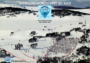
Poster - Kangaroo Hoppet 1992
The Kangaroo Hoppet is Australia’s premier long distance cross country ski race, and a member of the Worldloppet series of international cross country ski events. The first race at Falls Creek was held in 1979 under the name of “Australian Birkebeiner”. It was a 21km race with about 80 participants organised by the Birkebeiner Nordic Ski Club of Mount Beauty. The course started and finished at Falls Creek Alpine Resort and took participants out into the Bogong High Plains. After running the event for 10 years, it was decided they should become part of the Worldloppet series of marathon ski races. Representatives from the Birkebeiner Nordic Ski Club and the Australian Ski Federation attended the Worldloppet Annual Meeting in Finland in June 1990 to put the case for the acceptance of an Australian event into the Worldloppet series. Before being admitted, they had to demonstrate that the Birkebeiner Club could run a world class event, so three months later in August 1990 a 42km event named the Australian International Ski Marathon was held at Falls Creek together with a 21km Birkebeiner race and a 7km event called the Birkebeiner Lite. The event was approved by delegates from USA, Norway and Austria, in 1991 Australia became the 12th member of Worldloppet, with the condition that there had to be a name change. After some late night discussion allegedly involving red wine from North East Victoria the main event became the 42km Kangaroo Hoppet, with the minor events being the 21km Australian Birkebeiner, and 7km Joey Hoppet. In the winter of 1991, the first Kangaroo Hoppet was held. It was a great success and has been a regular fixture on the international ski calendar ever since. It features the main 42km event as well as a 21km event and a 7km event. The Hoppet brings the Australian snowfields to an international audience. In 1992 the Men's Winner was Gudmund Skjeldal from Norway in a time of 1:47:17. The winner of the Women's event was Beatrice Grunenfelder of Switzerland in a time of 2:12:49. This poster is significant because it documents an event which brings international attention to Falls Creek and the surrounding region.A large coloured poster featuring an aerial photo of cross country skiers from the 1991 event. The logo of the Kangaroo Hoppet is in the centre top position and the Worldloppet logo is in the bottom left corner.At top: AUSTRALIA' S WORLDLOPPET SKI RACE / FALLS CREEK VICTORIA / 29TH AUGUST 1992 Beside Worldloppet logo: Details from Race Secretary Box 192 Mt. Beauty 3699 Australia Photo: Ken Bell, PhotoMotionkangaroo hoppet, worldloppet events, falls creek, mt. beauty -
 Forests Commission Retired Personnel Association (FCRPA)
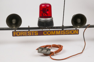
Red flashing light and sirens mounted on car rooftop rack
Used on some FCV passenger vehicles during the fire season. Could be activated from inside the vehicle as needed Fire tankers had lights and sirens permanently attachedNot common usage on passenger vehiclesRed flashing light and two sirens mounted on car roof rack. Includes FCV sign, radio aerial and public announcement (PA) system Could be operated from inside vehicleForests Commission Victoriabushfire, forests commission victoria (fcv) -
 Ringwood and District Historical Society
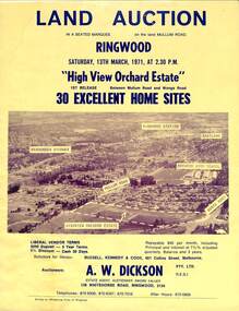
Flyer, Land Auction Sale Brochure, High View Orchard Estate, Ringwood, Vic. - 1971
Double-sided advertisement for Ringwood High View Orchard Estate land auction sale on Saturday, 13th March, 1971, including aerial photograph, map, and summary of local facilities and services.Subdivision includes Wonga Road, Oban Road, Sang Court, Ambrie Avenue, Hendra Grove, and Mullum Mullum Road. Agent - A.W. Dickson Pty. Ltd., 136 Whitehorse Road, Ringwood, 3134. Telephones: 870 6000, 870 6007, 870 7016, after hours 870 6868. A separate copy of the advertisement includes a local newspaper follow-up clipping reports thirty home sites grossing $102,350 at the auction. -
 Lakes Entrance Historical Society
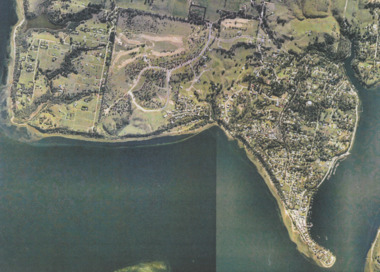
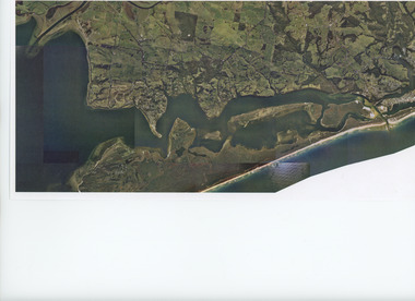
Photograph - Metung, Gippsland Ports, 2006 c
Colour aerial photograph showing Shaving Point at Metung including Chinamans Creek at the right housing subdivisions of Kingscove Estate Tambo Bluff Estate and Lake King on Gippsland Lakes Victoriaaerial photograph, topography, waterways, metung -
Tatura Irrigation & Wartime Camps Museum
Booklet, K Gregory, B Pearson, W Stewart et al, From Protectorate to Smaller Town, 1985
2nd book. L3518. Incorporating 125 years of education and achievement Murchison Primary School 1860-1985. Booklet for "Back to Murchison" 18-20 October 1985.Yellow soft cover booklet. Green text and 2 pictures on front. Top on of river scene. Lower scene of street buildings. Aerial scene of town on back cover. 79 pages -
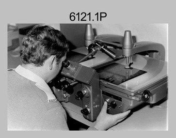 Bendigo Military Museum
photograph - Aerotriangulation Production – Army Survey Regiment, Fortuna, Bendigo, c1980
This collection of five photos was most likely taken in 1980. Wild PUG4 point transfer devices were used by technicians in Air Survey Squadron to stereoscopically view the photography containing the survey control points and the mapping aerial photography. The Control points were transferred from the control photography to the mapping diapositives of aerial photography by drilling their locations into the photographic emulsion. The Zeiss (Jena) Stecometer analytic stereocomparator for air photography was introduced at Air Survey Squadron in 1963. Aerotriangulation production was expedited using computers for analytical photogrammetric processes. The technician accurately measured between pass, tie, and survey control points on aerial photographs.Air Survey Squadron Aerotriangulation Section - Army Survey Regiment, Bendigo. c1980. This is a set of five photographs of Air Survey Squadron personnel operating aerotriangulation equipment at the Army Survey Regiment at Fortuna, Bendigo, c1980. Photographs .1P to .4P are on 35mm negative film and were scanned at 96 dpi. Black and white photo .5P is on photographic paper and was scanned at 300 dpi. They are part of the Army Survey Regiment’s Collection. .1) - Photo, black & white, c1980, Wild PUG4 point transfer device, unidentified technician. .2) - Photo, black & white, c1980, Wild PUG4 point transfer device, unidentified technician. .3) - Photo, black & white, c1980, Wild PUG4 point transfer device, unidentified technician. .4) - Photo, black & white, c1980, Zeiss (Jena) Stecometer, unidentified technician. .5) - Photo, black & white, c1980, Zeiss (Jena) Stecometer..1P to .5P No personnel are identified.royal australian survey corps, rasvy, army survey regiment, army svy regt, fortuna, asr, air survey, aerotrig -
 Federation University Historical Collection
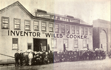
Book, Tulloch & King, Printers, M. McCallum's Ballarat District Citizens and Sports, 1916, 1916
A biographical gallery of "Who's Who" in public, political, official, judicial, patriotic, naval, military, charitable, professional, scientific, artistic, journalistic, ecclesiastical, religious, temperance, industrial, clerical, mercantile, commercial, aerial, scholastic, social club, musical, dramatic, friendly society, fraternal, athletic and sporting life, with Ballarat associations, past or present.Small hard covered brown book of 142 pages including advertisements.Stamped "The School of Mines Industries & Science Ballaratballarat district citizens and sports, m. m. mccallum, ballarat, citizens and sports at home and abroad, citizens and sports, political, official, judicial, patriotic, naval, military, charitable, professional, scientific, artistic, journalistic, ecclesiastical, religious, temperance, industrial, clerical, mercantile, commercial, aerial, scholastic, social club, musical, dramatic, friendly society, fraternal, athletic and sporting life, ballarat associations, clarendon college advertisement, wiles cooker, e. rowlands, koomah spa, thomas a. williams, leslie coulter, lela lake, margaret mcnanamny, leslie morshead, alice thwaites, james wiles, alfred williams -
 Lara RSL Sub Branch
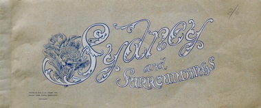
Booklet, Sydney and Surroundings Win and Co Sydney, circa 1945
Photos from 1945 era include Sydney Harbour Bridge, Aerial View looking South East McMahon's Point, Aerial view of Sydney Harbour Bridge looking South West from over Neutral Bay. Top portion of the Bulli Pass. An Entrancing View of the South Coast, from Sublime Point. Government House, Sydney. Central Square Railway Station. Booklet from WW2 era that displays old photographs of the Sydney area circa 1945Sydney and Surroundings Win and Co Sydney containing eight double sided pages of photograph of the Sydney area.Front Cover - Sydney and Surroundings. In bottom left hand corner - Printed by Winn & Co. Sydney, for Murray Views, Gympie, Queensland. Copyright. At top right hand corner in pencil is the price 2/6 On Back Cover - Stamp - Tivoli Bookshop 335 Castlereagh St, Sydney - Books, Magazines, Stamps sydney, winn & company, murray views, gympie, queensland -
 Orbost & District Historical Society
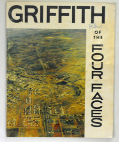
book, Riverina Commercial Press, Griffith, 1963
Albert Jaime Grassby, AM was an Australian politician who served as Minister for Immigration in the Labor Whitlam Government. He completed reforms in immigration and human rights, and is often known as the father of Australian "multiculturalism". Prior to this Grassby worked as a journalist and information officer for the CSIRO in Griffith, New South Wales.This item is a useful reference tool on the history of Griffith in New South Wales.A 46 pp paper back book titled, " Griffith of the Four Faces". on the front cover is a coloured aerial photograph of Griffith, New South Wales. The book contains coloured photographs and a history of the area.on front cover hand-written in blue pen - "M. Gilbert"griffith-new-south-wales griffith-history -
Glenelg Shire Council Cultural Collection
Photograph - Photograph - aerial view of Portland, c. 1954
Black and white aerial photograph of coastline around Portland. Black border, scale all sides, 5 rows of 3 't' at regular intervals. Mostly ocean, section of land jutting out into it.Front: '607 - 41 ' - handwritten, white, border 'RUN 8' 'PORTLAND', printed, white, border -
Glenelg Shire Council Cultural Collection
Photograph - Photograph - aerial view of Portland, c. 1954
Black and white aerial photograph of coastline around Portland. Black border, scale all sides, 5 rows of 3 't' at regular intervals. Only 10% land visible, top rightFront: '784 - 155- handwritten, white, border 'RUN 7 A PORTLAND', printed, white, borderaerial photography, central portland, portland harbour, south west coastline -
Glenelg Shire Council Cultural Collection
Photograph - Photograph - aerial view of Portland, c. 1954
Black and white aerial photograph of coastline around Portland. Black border, scale all sides, 5 rows of 3 't' at regular intervals. Same area as 8465, 8466, 80% land.Front: '607 - 63 ' - handwritten, white, border 'RUN 7 PORTLAND', printed, white, borderaerial photography, central portland, portland harbour, south west coastline -
Glenelg Shire Council Cultural Collection
Photograph - Photograph - aerial view of Portland, c. 1954
Black and white aerial photograph of coastline around Portland. Black border, scale all sides, 5 rows of 3 't' at regular intervals. Small area of ocean, rest land with lakes.Front: '820 -9' - handwritten, white, border 'RUN 5' 'PORTLAND', printed, white, lower borderaerial photography, central portland, portland harbour, coastline -
Glenelg Shire Council Cultural Collection
Photograph - Photograph - aerial view of Portland, c. 1954
Black and white aerial photograph of coastline around Portland. Black border, scale all sides, 5 rows of 3 't' at regular intervals. Very small section of ocean, bottom left.Front: '607 -86 ' - handwritten, white, border 'RUN 6- PORTLAND', printed, white, borderaerial photography, central portland, portland harbour, south west coastline -
Glenelg Shire Council Cultural Collection
Photograph - Photograph - aerial view of Portland, c. 1954
Black and white aerial photograph of coastline around Portland. Black border, scale all sides, 5 rows of 3 't' at regular intervals. Start of headland, 80/20 ocean to landFront: '784 - 149' - handwritten, white, border 'RUN 7 A PORTLAND', printed, white, borderaerial photography, central portland, portland harbour, south west coastline -
Glenelg Shire Council Cultural Collection
Photograph - Photograph - Aerial view from N.W. Port of Portland, 05/03/1971
Port of Portland Authority archives.Front: (no inscriptions) Back: (no inscriptions)port of portland archives, portland harbour -
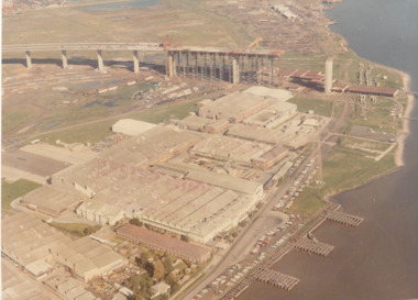 Port Melbourne Historical & Preservation Society
Photograph - Aerial view of West Gate Bridge under construction, 1960 - 1979
Colour aerial (faded) photograph of West Gate Bridge under construction with two land spans incomplete. "Rotten Row" (disused old piers) in the foreground. Aircraft factory and other industry in foreground."Master Copy . Not to be removed from Marketing department " lightly stamped on photo. and on reartransport, engineering, engineering - bridges, fishermans bend, industry, west gate bridge, rotten row, williamstown, yarra river -
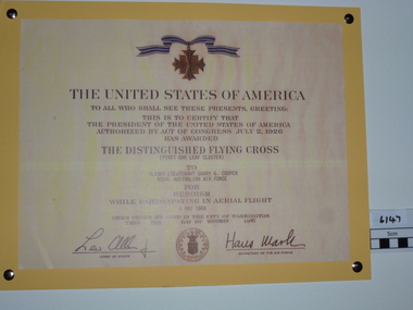 National Vietnam Veterans Museum (NVVM)
Certificate - Certificate, replica, The Distinguished Flying Cross, 1980
Certificate stating that the United States of America has awarded the Distinguished Flying Cross (First Oak Leaf Cluster) to Flight Lt. Garry Cooper of the RAAF for heroism while participating in aerial flight.distinguished flying cross, gary cooper (flgt lt.) -
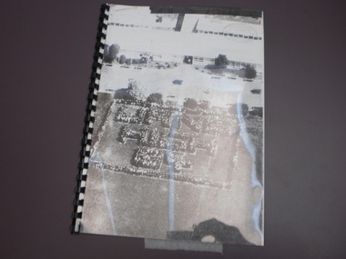 Wangaratta High School
WHS Yearbook -Korrumbeia, 1984
Black and white bound photocopy of the 1984 yearbook featuring a full page aerial photograph of WHS students standing in a crowd in the shape of text reading WANG HIGH 84 in front of the school buildings -
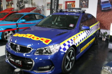 Trafalgar Holden Museum
Vehicle - VF2 SS, 2017
The VF was the final Australian built Commodore and was the finest and best equipped car ever built by that companyManufactured by GMH 2017Blue Bodied VF2 Holden Commodore. Blue and white check banding on sides Police warning lights on top with scanners and six aerials. Police sticker on bonnet, Highway Patrol singage on sidesPolice on bonnet, Holden emblem on both boot and bonnet centresvehicle, commodore, police car, holden -
 Lakes Entrance Historical Society
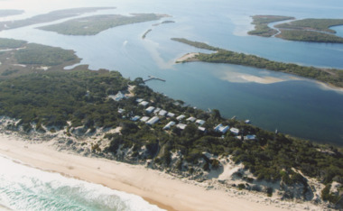
Photograph - Lakes Entrance, Gippsland Ports, 2006 c
Colour aerial photograph showing the entrance to Gippsland Lakes from Bass Strait westward to Reeves Channel Shaving Point at Metung through Lake King to Tambo River Gippsland Lakes Victoriaaerial photograph, waterways, township, topography, lakes entrance -
 Lakes Entrance Historical Society
Photograph - Gippsland Lakes, 2005 c
Colour aerial photograph of Ocean Grange on the Gippsland Lakes ocean beach ninety mile beach in foreground Cresent Island channel through to Lake King Raymond Island in distance Paynsville Victoriaaerial photograph, settlement, gippsland lakes -
 Bendigo Historical Society Inc.
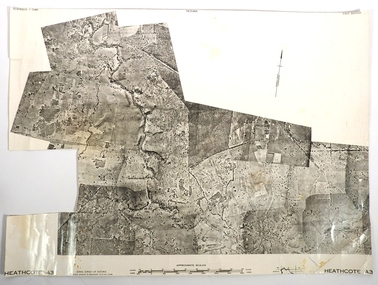
Map - FRED COWIE COLLECTION: AERIAL MAPS OF HEATHCOTE/EPPALOCK
Map, Heathcote A3, Aerial Survey of Victoria, Photo-map prepared by Department of Crown Lands.Campaspe River , Wild Duck Creek, Knowsley, Eppalock Weir.Fred Cowie,46 McIvor Rd ,Bendigo.map, heathcote, fred cowie -
 Robin Boyd Foundation
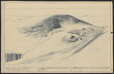
Drawing - Aerial perspective, Tower Hill Lake Reserve Museum, Jun-61
Project: Tower Hill Lake Reserve Museum drawn by Robin Boyd of Grounds, Romberg & Boyd. Drawing no 1. Aerial perspectiveSketch, Dyeline -
City of Kingston
Photograph - Black and white, 5 January 1984
Moorabbin, Cheltenham and Highett are suburbs in the City of Kingston with a diverse mix of development and zoning. The market gardens, farms and paddocks have gradually been sub-divided into housing and industrial estates and associated infrastructure such as schools and shopping facilities. The area includes many parks, reserves and golf courses.This aerial image covers a diverse section of the City of Kingston, taking in the suburbs of Cheltenham, Moorabbin, Beaumaris and Highett. By 1984, the market gardens of the district have been replaced by housing and factories. The Gas and Fuel state-of-the-art Scientific Services Department is visible on Nepean Highway Highett. The CSIRO Highett site can also be seen. Both sites have now been demolished and have undergone remediation. The Southland site is visible and yet to be redeveloped by Westfield. This image portrays the diversity of development in the City of Kingston with a mixture of green spaces, housing and commercial and industrial features.Aerial photograph of Cheltenham, Beaumaris, Moorabbin and Highett within the City of Kingston. The area depicted in the 1984 aerial view includes Eden Street and Edward Street, Cheltenham (top left), Weatherall Road and Reserve Road, Cheltenham/Beaumaris (top right), Turner Road and Chesterville Road, Moorabbin (bottom left), Nepean Highway (left section), Graham Road and Middleton Street, Highett (bottom right). A large section of this image includes Cheltenham Park and Victoria Golf Club.White text: 3831-219 Lens information [indecipherable] RINGWOOD M/S 7922-3 RUN 15 Clockface image 5,300' ASL VIC DLS© 5-1-84cheltenham, highett, industrialisation, urbanisation, moorabbin, beaumaris -
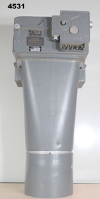 Bendigo Military Museum
Equipment - AIR CAMERA ACCESSORY, Williamson Mfg. Co. Ltd
This Gear box universal, with its Cone assembly ( inc lens) in conjunction with Magazine 500 exposures unit ( see CAT 5561) is part of the F22 aerial camera assembly. As an assembly, the type F22 aerial camera came into RAF and RAAF service c1942. It was used by the RAF over Europe and by the RAAF extensively through the Sth. West Pacific area of operations, during WW2. This type of camera was used through the Vietnam war up to the early 1980's. The F22 camera assembly when mounted in the reliable Canberra aircraft, did aerial survey work in PNG, Indonesia, Malaysia and Sumatra and the Australian mainland. This type of camera was used in Spitfires, Mosquitos, Avro Lincolns and Canberra aircraft.Heavy, metal construction. The base is a rectangular box shape and mounted to that is a funnel shaped tube. Inside the tube are numerous small baffles around the sides painted matte black. The box has a 7 pin electrical connector. The box section can be opened by releasing catches. It has a timber base. Near the mouth of the tube, outside, is a panel with a slot and indentations F5.6 F8 F11 F16.There is a tape label near mouth if tube with writing embossed "LENS S/NO 2767849" The box has a label "GEARBOX/UNIVERSAL. MODEL 14A/4249 SERIAL No. 1685"aviation, reconnaisance, camera, photography -
 Department of Energy, Environment and Climate Action
Foldable Stereoscope
This stereoscope was used to view a pair of separate and overlapping aerial photos as a single three-dimensional image. This smaller foldable unit could be easily used in the field but larger, mirror stereoscope was used in offices. The aerial images were used to map forest types, timber stands, new roads and tracks, firebreaks, boundaries of timber harvesting, plantations, bushfires, insect and disease attack and so on In 1928, the Forests Commission undertook its first major aerial photography project over 15,000 acres of forest which is said to be the first of its kind in Australia. During the Second World War, large areas of Victoria were photographed by RAAF and used to produce orthophoto maps. By 1945 aerial photography of 13,000 square miles (3.4 M ha) was completed, including much of the inaccessible eastern forests. The Forests Commission started developing its own small format photography in the early 1970s. Simple, cheap and rapid methods of obtaining photographs using 70mm and 35mm cameras were developedFoldable plastic stereoscope in box Benallaforests commission victoria (fcv), surveying, forest measurement -
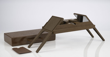
 Department of Energy, Environment and Climate Action
Stereoscope
This stereoscope was used to view a pair of separate and overlapping aerial photos as a single three-dimensional image. Smaller units and could be easily used in the field but this larger, mirror stereoscope was used in offices. The aerial images were used to map forest types, timber stands, new roads and tracks, firebreaks, boundaries of timber harvesting, plantations, bushfires, insect and disease attack and so on In 1928, the Forests Commission undertook its first major aerial photography project over 15,000 acres of forest which is said to be the first of its kind in Australia. During the Second World War, large areas of Victoria were photographed by RAAF and used to produce orthophoto maps. By 1945 aerial photography of 13,000 square miles (3.4 M ha) was completed, including much of the inaccessible eastern forests. The Forests Commission started developing its own small format photography in the early 1970s. Simple, cheap and rapid methods of obtaining photographs using 70mm and 35mm cameras were developedFoldable metal stereoscope in wooden box with mirror covers Ex Dept of Defenceforests commission victoria (fcv), surveying, forest measurement -
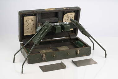
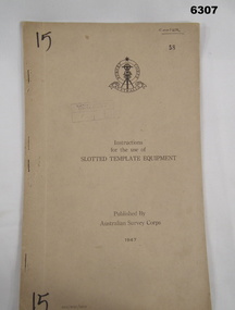 Bendigo Military Museum
Manual - Australian Survey Corps 1947 - Instructions for the use of Slotted Template Equipment, Australian Survey Corps, 1947
This is an instruction manual describing in detail the construction of the templates used for producing map compilation sheets from aerial photographs, and how the system works.Foolscap size, soft carboard covers, 9 x numbered pages, 3 x fold out pages containing two photos on each. Australian Survey Corps Badge on cover. Stapled and re-stapled on Left hand edge.Front Cover, "15" Top Left and Bottom Left corner, "COOPER" and stamped "58" in Top Right, "AHQ/Misc/0015" Bottom Left Corner, Stamped "Eastern Command Survey Service copy 5"royal australian survey corps, rasvy, fortuna, army survey regiment, army svy regt, asr