Showing 26605 items
matching buchan-river-view-hotel
-
 Ringwood and District Historical Society
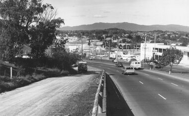
Photograph, Maroondah Highway West, Ringwood- 1974. Easterly view from Heatherdale Road
Black and white photograph (2 copies)Written on backing sheet, "View from Ringwood Hill - 1974". -
 Ringwood and District Historical Society
Photograph, View of the Dandenongs from Loughnan Hill (no date)
Catalogue card reads, "View of the Dandenongs from Loughnan Hill". -
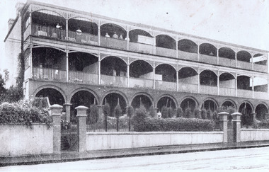
 St Kilda Historical Society
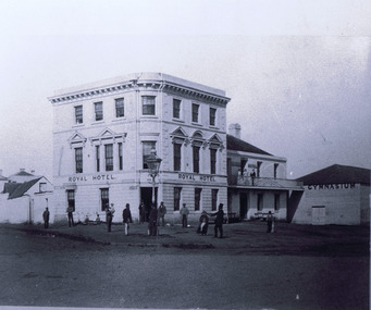
Photograph, Royal Hotel
The Royal Hotel. Built 1847, demolished 1930s. St Kilda's first hotel.black and white photograph, copy, unmounted, good condition. Inscription "D.J Taggart, 58 Glenhuntly rd, Elwood 3184" -
 Buninyong & District Historical Society
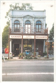
Photograph - Original Photograph, Derek Leather, Old Eagle Hotel, Warrenheip St in 1995, Original photograph made 1970-80
Historic BuildingsColour Photo Old Eagle Hotel, Warrenheip St in 1995, as "Garden Delights" store, new veranda/balcony.buninyong, warrenheip st, eagle hotel, garden delights -
 Inverloch Historical Society
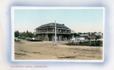
004220 - Postcard - Esplanade Hotel, Inverloch, 1906
Colourised postcard - Souvenir Post Card Building with bar above Hotel. Separate Bakehouse behind Vietz's Store -
 Stawell Historical Society Inc
Slide, Ian McCann, Remains of the Royal Exchange Hotel
Person dressed as Rabbit in car passing demolished Royal Eschange hotel next to police station, Patrick street -
 Tarnagulla History Archive
Photograph, Victoria Hotel & Theatre (Public Hall) and Commercial Road, Tarnagulla, early 1990s
Donald Clark Collection. A colour photograph depicting the Victoria Hotel & Theatre (Public Hall) and section of Commercial Road, Tarnagulla Original photograph. -
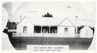 Buninyong & District Historical Society
Photograph - Photograph of Original Photograph, "Carriers Arms" hotel, Clarendon
historic, social, buildings, Photo of B/W photograph of "Carriers Arms" hotel, Clarendon, date unknown - built 1855, demolished 1930"The Carriers Arms", Clarendon Built 1855, demolished 1930clarendon, carriers arms, hotel, -
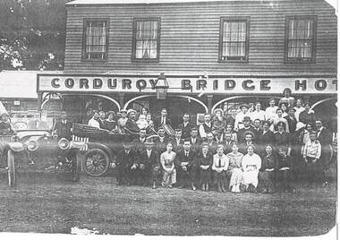 Buninyong & District Historical Society
Photograph - Copy of original photograph, Corduroy Bridge Hotel, Clarendon around 1914, Corduroy Bridge Hotel, Clarendon around 1914
BuildingsB&W copy of original photograph, Corduroy Bridge Hotel, Clarendon around 1914. Burnt down in 1916. -
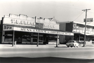 Wodonga & District Historical Society Inc
Photograph - Mann Collection Album - Wodonga, High Street West - T. B. Erlandsen & Son. and Terminus Hotel, C. 1980s
Elaine Mann was married to David Mann, a successful Wodonga businessman and community leader who passed away in Wodonga in June 2012. David was a member of the Mann family who began their business in Wodonga in 1920. Elaine was a teacher in Wodonga for many years and an active member of the community.This photo collection is of significance as it documents how the businesses and buildings in Wodonga have evolved and contributed to community throughout the late 20th century.Wodonga, High Street West Businesses including T. B. Erlandsen & Son. and the Terminus Hotel. Thorald Erlandsen purchased his premises in the 1950s. The building was previously owned by John Whan. It started out as a general store but was later extended to include a drapers. The building sold in 1966 to Manns. The Terminus Hotel was built in 1873. It was purchased by Annie and George Allen in 1879. In 1888 they added extensions including a billiard room, a dining room and 18 other rooms. After the death of her husband, Annie Allen continued to run the Terminus Hotel. She later married John Haldon and was licensee of the hotel until 1893 when the license was transferred to William Carkeek. Carkeeks owned the hotel from 1900 - 1903 and again from 1906 - 1909. It was destroyed by fire in 1998 and the building demolished in 1999. In 2021 it is the location of Tristar Medical Centre.wodonga businesses, high st wodonga, t. b. erlandsen & son, terminus hotel -
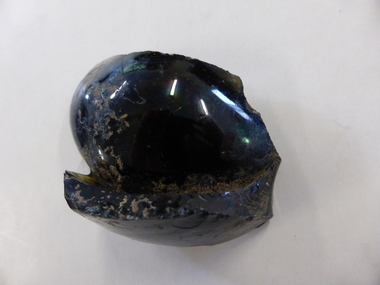 Warrnambool and District Historical Society Inc.
Bottle, Bottle fragment Woodford hotel est 1845, 19th century
This fragment was found in Bridge Road, Woodford on the site of the Travellers’ Rest Hotel, Woodford and it is believed that it may date from the time when the hotel was operating. The Travellers’ Rest Hotel in Woodford was established some time in the 1840s with the first known date, 1847. It pre-dates the settlement of Warrnambool founded in late 1847. The Travellers’ Rest Hotel was established by William Kirby and his wife Mary took over the hotel management when her husband was drowned in August 1847. The hotel had seven other licensees and closed in 1875. If this item comes from the time of the Travellers’ Rest Hotel in Woodford then it is of considerable interest as an early memento of that hotel and the early days of Woodford. This is a fragment of a black bottle or other domestic item. It is made of heavy glass and is curved and could be part of the base of the object. history of woodford, travellers’ rest hotel, woodford, warrnambool history -
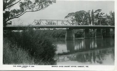 Orbost & District Historical Society
black and white photograph, Rose Stereograph Company, first half 20th century
A new bridge over the Snowy River at Orbost was opened for traffic on June 20th 1922. It was a new timber and steel girder structure, a joint Country Roads Board — Victorian Railways venture and was built and completed at a cost of £41,000 (the steel girders came from the Flinders Street viaduct reconstruction). Subsequently it was decided not to take the railway across the river, and the bridge was only ever used by road traffic. Postcards form a vital part of social and historical records for researchers. This postcard is a pictorial record of an earlier bridge across the Snowy River at Orbost.A black / white postcard photograph of a bridge over the Snowy River at Orbost.0n front - The Rose Series P1200 copyright Bridge Over Snowy River Orbost Vic.snowy-river-bridge -
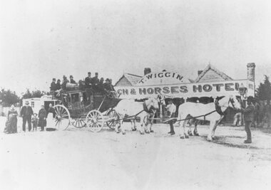 Ringwood and District Historical Society
Photograph, Original Coach and Horses Hotel, south side of Whitehorse Road, Ringwood 1875
Inscription below photograph reads, "Original Coach and Horses Hotel, Whitehorse Rd. 1875". (Thomas Wiggin) -
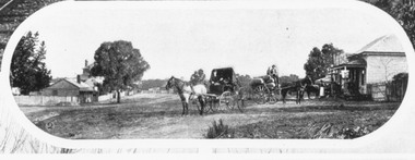 Ringwood and District Historical Society
Photograph, Mount Dandenong Road, Ringwood. Blood's store on right, Club Hotel behind tree, Cornell's store on left. c.1900-1910
Written on backing sheet, "Blood's store on right, Club Hotel behind tree, Cornell's store on left". -
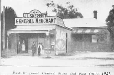 Ringwood and District Historical Society
Photograph, Skerrett's Store and Post Office, 1923. Diagonally opposite from Club Hotel in Mount Dandenong Road
Catalogue card reads, "Skerrett's Store and Post Office, 1923. Diagonally opposite from Club Hotel." -
 St Kilda Historical Society
Photograph, Oslo Hotel
black and white photograph mountedHand written on the back: Oslo Hotel, 38 Grey Street, formerly Westbourne Terrace built 1861 -
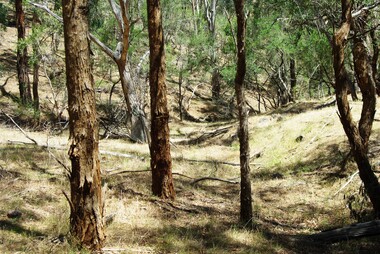 Greensborough Historical Society
Photograph - Digital image, Marilyn Smith et al, Janefield Precinct view November 2014, 27/11/2014
View of the Janefield Precinct taken November 2014. The remains of this site are between Greensborough and Janefield. A RAAF Hygiene Training Camp was located on the Plenty River, just south of the Janefield community. It was in use from 1944 to 1946. The Camp was constructed from salvaged materials. Instruction included building and maintenance of grease traps, latrines, elementary plumbing and carpentry.Early remains of a WW2 training campDigital colour photograph.janefield, raaf hygiene training camp janefield -
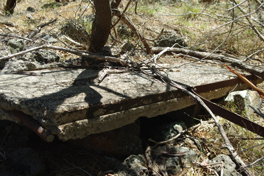 Greensborough Historical Society
Photograph - Digital image, Marilyn Smith et al, Janefield Precinct: Side view showing reinforcements, 27/11/2014
Janefield Precinct: Side view showing reinforcements. The remains of this site are between Greensborough and Janefield. A RAAF Hygiene Training Camp was located on the Plenty River, just south of the Janefield community. It was in use from 1944 to 1946. The Camp was constructed from salvaged materials. Instruction included building and maintenance of grease traps, latrines, elementary plumbing and carpentry.Early remains of a WW2 training camp Digital colour photograph. -
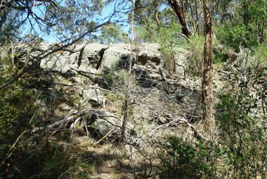 Greensborough Historical Society
Photograph - Digital image, Marilyn Smith et al, Janefield Precinct: View of edge of basalt flow, 27/11/2014
Janefield Precinct: View of edge of basalt flow. The remains of this site are between Greensborough and Janefield. A RAAF Hygiene Training Camp was located on the Plenty River, just south of the Janefield community. It was in use from 1944 to 1946. The Camp was constructed from salvaged materials. Instruction included building and maintenance of grease traps, latrines, elementary plumbing and carpentry.Early remains of a WW2 training camp Digital colour photograph.janefield -
 Orbost & District Historical Society
programs, 1961
The Snowy River Shire was a local government area in the Australian Alps region of New South Wales, Australia from 1939 until May 2016. It was named after the Snowy River that runs through it. Prior to 1936, it had been named as Dalgety Shire since establishment in 1906. This opening of the Monaro - Gippsland Road took place on 4th May 1961. There had long been a movement in Monaro for the construction of a road to connect Monaro and Gippsland, via Inglebyra and Black Mountain. The only track was for stock, made by pioneers many years ago, and it was very circuitous. It was stated at a meeting at Dalgety that the road would open up large areas for settlement for grazing, and for timber suitable for bridgé building. The road would assist stock deal ing between Monaro and Gippsland. It would also considerably shorten the distance from Victoria for tourists visiting Canberra and Kosciusko. A committee was formed to put the proposal before the Dalgety Shire Council in the 1930s.This item is a useful research tool.Four copies of a road opening program. It has black print on white. There are black / white photographs, historical details and details of the official opening.program monaro-road snowy-river-shire -
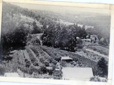 Mt Dandenong & District Historical Society Inc.
Photograph, 1913 View Over Logan's House in Village Settlement, 1913
Photograph taken in 1913 from Barbers Road showing the view down the valley. Roof in foreground is house on Bob Logan's Lot 28 in the Village Settlement. This photograph has a detailed inscription on the back handwritten by John Lundy-Clarke in 1974.1913 view over Logan’s house on Village Settlement Lot 28 taken from Barber’s Road. This is the house that the runaway log leaped over in 1930 to land far down the orchard row beyond the house. “Shiloah” is centre partly behind the clump of trees and the paddocks of Child and Richardsons pioneer selections are in the background. Link Road is centre right.logan, bob logan, robert logan, barbers road, shiloah, child, richardson, link road -
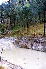
 Greensborough Historical Society
Slide - Photograph, John Ramsdale, Plenty River: Slide 105, 1990s
Photograph shows a river and bank (Plenty River) with some rubbish.Part of the John Ramsdale collection of slides and audio visual material.Colour photograph scanned from slide.No maker's marks. No caption on slide.plenty river, pollution -
 Greensborough Historical Society
Slide - Photograph, John Ramsdale, Plenty River catchment: Slide 123, 1990s
Photograph shows a river and bushland, part of the Plenty River catchmentPart of the John Ramsdale collection of slides and audio visual material.Colour photograph scanned from slide.No maker's marks. No caption on slide.plenty river -
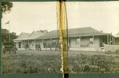 Orbost & District Historical Society
black and white photograph, C1900
The first settler to occupy the Marlo township area was James Stirling around the year 1875. He built a bark hut on the bluff that had two rooms, bark walls, earthen floors and a shingle roof. By 1884, this structure had expanded to a 9 roomed accommodation house and in 1886 became the Marlo Hotel when a liquor license was granted. The Governor-in-Council declared Marlo to be a township on 18 February 1889. During May 1889, the government surveyor, E.L. Bruce set out 19 sections of the new township, with the first sales of subdivided land occurring the following May. At this time, Stirling's Marlo Hotel was the unofficial hub for the community. It was a general store, accommodation house and the unofficial post office, with settlers taking turns in bringing the mail from Orbost or Cunningham. This continued until Aug 1942, and in 1969 was located in a house adjacent to the Marlo Hotel, before being transferred to the Marlo General Store in this year. The official Post Office List states the Marlo Post Office opened around 1902. in 1925, the "Marlo House" (a nine room accommodation guest house) was granted a liquor licence. The "Marlo House" became "The Marlo Hotel". The Marlo Hotel was popular with many Orbost and district settlers, who travelled to Marlo by horseback or buggy. The Marlo Hotel, perched on the hill overlooking the estuaries and the entrance is a significat building in Marlo. Established in 1886, it has been operating for over 120 yearsA black / white photograph of the Marlo Hotel. Patrons are standing on the verandah and lawns. A horse-drawn carriage is on the left. The photograph is on a green buff card with a rough edge on R H side.on back - " Old Marlo Hotel"marlo-house marlo-hotel stirling-james -
 Port Melbourne Historical & Preservation Society
Plan - Soundings, Yarra River, Operation Division, Port of Melbourne Authority, Jul 1987
Port of Melbourne Authority. Plan: soundings of Yarra River at entrance Beacon No 23melbourne harbor trust - port of melbourne authority, beacon no 23 -
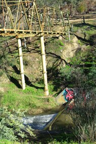 Greensborough Historical Society
Photograph - Digital Image, Marilyn Smith, Plenty River at the aqueduct crossing Greensborough 2019, 02/07/2019
The Plenty River at the aqueduct crossing, 2019, showing graffiti on the river bank rocks. Originally part of the Maroondah Aqueduct pipeline, all that remains is the bridge that once carried the pipe over the Plenty River. This photograph was taken from the Plenty River Trail in Greensborough. 2 colour digital photographsplenty river trail, maroondah pipetrack, maroondah aqueduct, plenty river, graffiti -
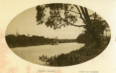 Lakes Entrance Historical Society
Photograph - P.S. Tanjil, Vogt. W S, 1915 c
Black and white photograph showing P S Tanjil on Tambo River. Water level high in river, note bushes in water. Eucalypt hanging over the river on right. Thick vegetation on banks. Swan Reach VictoriaTambo Riverships and shipping, waterways -
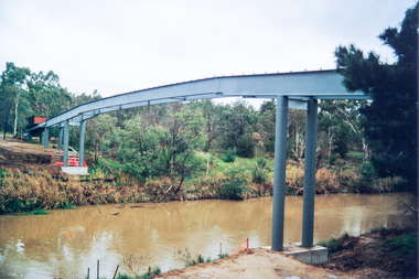 Eltham District Historical Society Inc
Photograph, Doug Orford, Bridge works across Yarra River at rear of Eltham Lower Park, June 2004, 2004
Three colour photographs showing commencement of construction of Eltham-Templestowe footbridge over Yarra River off Homestead Road, Eltham which was completed July 2004.bridges, yarra river, eltham, eltham south, templestowe, eltham lower park, lenister farm, homestead road -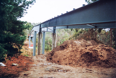
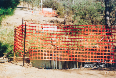 Eltham District Historical Society Inc
Photograph, Doug Orford, Commencement of bridge works across Yarra River at rear of Eltham Lower Park, May 2004, 2004
Two colour photographs showing commencement of construction of Eltham-Templestowe footbridge over Yarra River off Homestead Road, Eltham which was completed July 2004.bridges, yarra river, eltham, eltham south, templestowe, eltham lower park, lenister farm, homestead road