Showing 173806 items
matching pitt-street
-
 Stawell Historical Society Inc
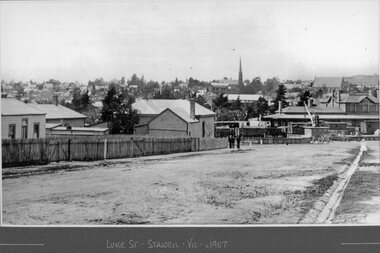
Photograph, Streetscape of Stawell from Luke Street 1907
Shows Railway Station with Loading Crane. Coffee Palace can be seen near St Matthews Church. Grampians Freestone Guttering visible.Luke Street Stawell Vic c1907railways, transport -
 Stawell Historical Society Inc
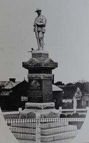
Photograph, Soldiers’ Memorial World War 1 in Main Street -- Different angle
Soldiers’ Memorial WW1 Stawell. View looking towards corner of St George and Victoria Streets. Coffee Palace formerly Castlemaine Hotel behind. The photo is a copy of the original owned by Mrs. Joyce Ward.Black & white photograph of Soldiers Memorial WW1. The image is predominately of the Soldiers memorial and looking towards the corner of St. George & Victoria Streets. The left- and right-hand bottom corners of the photo are rounded.stawell ww1 ww2 -
 Stawell Historical Society Inc
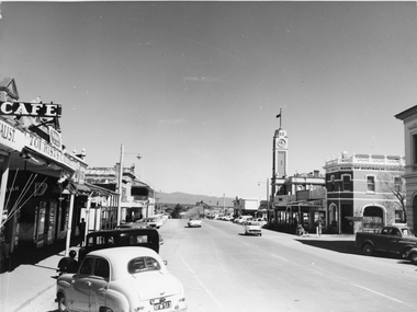
Photograph, Main Street Stawell looking West towards the Town Hall, on the right c 1960's
Main Street Stawell looking West including Town Hall Shops and Motor Vehicles c 1960's. This photo was taken by M. Robson before being donated to the society. The photo of Main St. was taken before it was made into a Mall, now know as "Gold Reef Mall". The street reopened to traffic in 2005.Black & white photograph of Main St Stawell looking towards the Grampians. The view includes the Town Hall & Bank of Australia on the right, with shops either side and two vehicles travelling along the road with vehicles parked along the street c 1960's.stawell business streetscape -
 Eltham District Historical Society Inc
Photograph, View north east from Porter Street, Eltham, 1994, 1994_
Colour photograph of view north east from Porter Street, Eltham near Ely Street, 1994porter street, eltham -
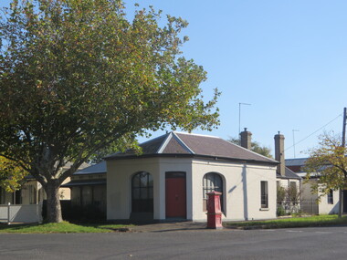 Ballarat Heritage Services
Photograph, Clare Gervasoni, House in Lyons Street South, Ballarat, 2020, 13/04/2020
Colour photograph of a former corner store in Lyons Street South, Ballarat, near the intersection of Sebastopol Street.ballarat, cast iron, lyons st, lyons street south, architecture -
 Ballarat Heritage Services
Photograph, Clare Gervasoni, Former Corner Store in Lyons Street South, Ballarat, 2020, 13/04/2020
Colour photograph of a former corner store in Lyons Street South, Ballarat, near the intersection of Sebastopol Street.ballarat, cast iron, lyons st, lyons street south, architecture -
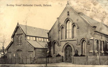 Ballarat Heritage Services
Photograph, Barkly Street Uniting Church
Postcard showing Ballarat's Barkly Street Methodist Church, later known as Barkly Street Uniting Church.A plaque reads "This plaque is in memory of the pioneers of this community and the Methodist Church est circa 1853 in a canvas tent. This brick building was built in 1859 with collections from the congregation. First Minister of the church was the Reverend Theopholis Taylor 1829 ~ 1858 -and the Methodist Church in 1977 became part of the Uniting Church in Australia.barkly street uniting church, barkly street methodist church, religion, theopholis taylor -
 Ringwood and District Historical Society
Photograph, 43 Ringwood Street. Corner of Nelson Street. Doctors consulting rooms before demolition 1987
Written on back of photograph, "9/1/87. 43 Ringwood Street. Corner of Nelson Street. Doctors consulting rooms. The doctors have moved out. To be wrecked and new building to be erected. Previously prof. room (Dr. Vaughan)" -
 Marysville & District Historical Society
Photograph (Item) - Colour photograph, Travel Victoria, 2004
A colour photograph of the view looking down Sedgwick Street towards Lyell Street in Marysville in Victoria.A colour photograph of the view looking down Sedgwick Street towards Lyell Street in Marysville in Victoria.sedgwick street, lyell street, marysville, victoria, travel victoria, photograph -
 Ballarat Heritage Services
Photograph, Clare Gervasoni, 105 Lyons Street South, Ballarat Central from Dana Street, 28/05/2023
105 Lyons Street South, Ballarat Central is a double brick Spanish Mission house with slate roof.105 lyons st south ballarat central, spanish mission, architecture, slate roof -
 Ballarat Heritage Services
Photograph, Clare Gervasoni, 105 Lyons Street South, Ballarat Central from Dana Street, 05/2023
This photograph was taken while painters were on-site, the colour changing from green to grey. 105 Lyons Street South, Ballarat Central is a double brick Spanish Mission house with slate roof.105 lyons st south ballarat central, spanish mission, architecture, slate roof -
 Ballarat Heritage Services
Photograph, Clare Gervasoni, 105 Lyons Street South, Ballarat Central from Dana Street, 04/2023
105 Lyons Street South, Ballarat Central is a double brick Spanish Mission house with slate roof.105 lyons st south ballarat central, spanish mission, architecture, slate roof -
 Ballarat Heritage Services
Photograph, Clare Gervasoni, 105 Lyons Street South, Ballarat Central from Dana Street, 15/06//2023
Recently painted.105 Lyons Street South, Ballarat Central is a double brick Spanish Mission house with slate roof.105 lyons st south ballarat central, spanish mission, architecture, slate roof -
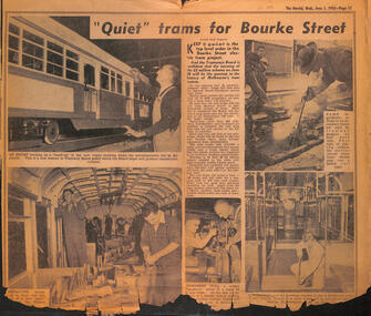 Melbourne Tram Museum
Newspaper, Herald Sun, "Quiet trams for Bourke Street", 1-6-1955
Provides information about the construction of the Bourke Street lines, new silent trams and track construction in particular Thermit welding. Shows the emphasis on the use of silent trams and the methods of achieving this.Yields information about the construction of new silent trams and the Bourke Street lines.Newspaper cutting - "Quiet trams for Bourke Street" - The Herald 1 June 1955 with an article and five photographs of new trams under construction, a model of PCC 980 and track construction, including East Preston depot.tramways, trams, bourke street, new tramways, silent trams, w7 class tram, new trams, thermit welding, tram 980, model trams -
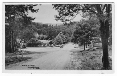 Marysville & District Historical Society
Postcard (Item) - Black and white postcard, Valentine Publishing Co. Pty. Ltd, Main Street, Marysville. V.3, 1923-1963
An early black and white photograph of the Main Street in Marysville, Victoria.An early black and white photograph of the Main Street in Marysville, Victoria. This street is now known as Murchison Street. In the background can be seen the Australia Hotel which became the Cumberland Hotel. The Cumberland Hotel was destroyed in the February 2009 Black Saturday bushfires and the Peppers Marysville was constructed on the site. Also in the background can be seen a sign with an arrow pointing to the Mary-Lyn Guest House which was also destroyed in the 2009 bushfires. This postcard was published by the Valentine Publishing Co. Pty. Ltd. as a souvenir of Marysville.VALENTINE'S/ POST CARD/ A GENUINE PHOTOGRAPHmurchison street, marysville, australia hotel, victoria, postcard, valentine publishing co, souvenir, cumberland hotel, mary-lyn guest house, 2009 black saturday bushfires -
 Marysville & District Historical Society
Postcard (item) - Black and white postcard, Valentine Publishing Co. Pty. Ltd, Main Street, Marysville. V.3, 1923-1963
An early black and white photograph of the Main Street in Marysville, Victoria.An early black and white photograph of the Main Street in Marysville, Victoria. This street is now known as Murchison Street. In the background can be seen the Australia Hotel which became the Cumberland Hotel. The Cumberland Hotel was destroyed in the February 2009 Black Saturday bushfires and the Peppers Marysville was constructed on the site. Also in the background can be seen a sign with an arrow pointing to the Mary-Lyn Guest House which was also destroyed in the 2009 bushfires. This postcard was published by the Valentine Publishing Co. Pty. Ltd. as a souvenir of Marysville.VALENTINE'S/ POST CARD/ A GENUINE PHOTOGRAPH 1940murchison street, marysville, australia hotel, victoria, postcard, valentine publishing co, souvenir, cumberland hotel, mary-lyn guest house, 2009 black saturday bushfires -
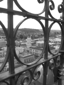 Federation University Historical Collection
Photograph, Lisa Gervasoni, Ballarat Post Office from Town Hall Tower, 2007
Aerial view of the Ballarat Post Office, corner of Sturt Street and Lydiard Street North, taken from the tower of the Ballarat Town Hall, corner of Sturt Street and Armstrong Street South. The Post Office was opened in December 1858. Photograph taken through the wrought iron of the tower in 2007. The tower and main entrance to the Post Office face Lydiard Street North. Other buildings from the same era are the former Bank of Australia, opposite corner, and the Mining Exchange. In the distance is Black Hill, an old mining area.Black and white photograph of the Ballarat Post Office on the corner of Sturt Street and Lydiard Street North, taken from the tower of the Ballarat Town Hall corner of Sturt Street and Armstrong Street South. View is taken through the wrought iron of the tower. post office, town hall, tower, wrought iron, sturt street, lydiard street, armstrong street, bank of australia, mining exchange, black hill -
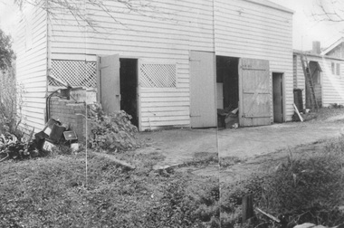 Surrey Hills Historical Society Collection
Photograph, Coach house at 'St Abbs', 33 York Street, Mont Albert
The photo is of the coach house at 'St. Abbs', 33 York Street. John Inglis Lothian, publisher, bought St Abbs in 1903 and lived here with his family until 1908. Prior to this the property had been part of Isiah Ainger's farm. The San Miguel family lived there from 1911-1923 and in 1926 Thomas Lothian bought 'St Abbs' and his family lived there until 1974. As the donor was Miss Jean Lothian it is assumed that the photo was taken during one of the periods the Lothian family occupied the property and more likely during the earlier period. A black and white photograph of a wooden building with a number of doors and windows with lattice work in place of glass. There is a concrete area in front of the building and a ladder leaning up against the building at the right hand end.york street, surrey hills, 'st abbs', house names, san miguel family, ainger farm, lothian family, coach house, isiah ainger, thomas lothian, john inglis lothian -
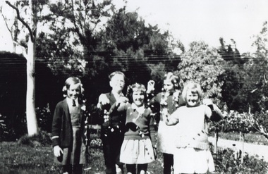 Surrey Hills Historical Society Collection
Photograph, Children at Tantallon, 49 York Street in the 1930s, 1930s
This was the home of John Inglis Lothian, father of Thomas Lothian of St Abbs 33 York Street, Mont Albert. John Inglis Lothian was a bookkeeper, who with his wife Lillias Charlotte, née Smith, arrived in Melbourne in July 1888, John having come to represent the publishing firm of Walter Scott. The children had been invited to a garden party where they entertained themselves making daisy chains. Left to right: Emily Broadfoot, David Dory, Betty Hopkinson; at back John Hopkinson; front right Jean Lothian.A black and white photograph of some children holding daisy chains they have made.tantallon, house names, york street, mont albert, (mr) john lothian, (mr) thomas lothian, (miss) emily broadfoot, (mr) david doery, (miss) betty hopkinson, (miss) joan hopkinson, (miss) jean lothian, john inglis lothian, thomas carlyle lothian -
 Whitehorse Historical Society Inc.
Photograph, Station Street, Mitcham, 1/10/2000 12:00:00 AM
Coloured photograph of Station Street Mitcham looking north. Trees on Mitcham Mall (formerly Britannia Street) in distancestation street, mitcham, britannia mall mitcham, britannia street -
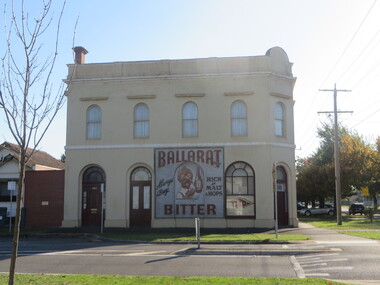
 Ballarat Heritage Services
Photograph, Lisa Gervasoni, Former Cuthbert's Legal, Lydiard Street North, Ballarat, 15/08/2007
Former Cuthbert's Legal on the corner of Lydiard Street North and Mair Street, a double storey building on bluestone footings. cuthbert's legal, lydiard street north, architecture -
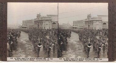 Linton and District Historical Society Inc
Stereograph, The Rose Stereographs, Melbourne, Sydney, Wellington and London, 12,921 Farewell Parade, Australian Expeditionary Force, Elizabeth Street, Melbourne, Copyright 1914
One of two sets of stereographs donated by the O'Beirne family along with a stereoscope for viewing (Stereoscope is Registration no. 2014-51).Military band leads a large group of soldiers along Elizabeth Street, Melbourne. Spectators also line the street."12,921 THE FAREWELL PARADE OF THE AUSTRALIAN EXPEDITIONARY FORCE. The Troops / Marching along Elizabeth St., Melbourne."stereographs, australian expeditionary force -
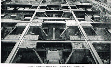 Melbourne Tram Museum
Photograph - Illustration, Melbourne & Metropolitan Tramways Board (MMTB), "Resilient crossings - Bourke Street - William Street Intersection", mid 1950's
Illustration, black and white, printed on gloss paper, reproduction of a MMTB report of photographs of the "Resilient crossings - Bourke Street - William Street Intersection", mid to late 1950's? May be from an MMTB Annual Report. Shows the nature of the crossing with the resilient inserts - it did not work as planned.trams, tramways, bourke st, william st, trackwork, construction -
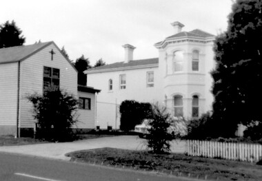 Surrey Hills Historical Society Collection
Photograph, Yielima, 31 Erasmus Street, Surrey Hills
Known as ‘Yielima’ 1888-1922 and ‘St. Aubins’ 1922-1956, this ‘modernized’ mansion was built about 1887 for Edward Kellett. He was born in Chorley, Lancashire, England. Edward Kellett married Selina Wells in 1852 at St Peters, Eastern Hill. She was born in c1827 in Aston Clinton, Buckinghamshire, daughter of William Wells and Elizabeth Allan. The family arrived from Aylesbury, Buckinghamshire on the 'Osprey' on 22 March 1849. The couple had 8 children - 5 girls and 3 boys; 3 died in infancy. All were born in Collingwood before the family came to Surrey Hills. Edward's funeral notice in The Argus of 11 July 1893 states that he was a corn merchant of Exhibition Street. His property was sworn at 1512 pounds, 1232 in realty and 280 pounds personally. He was buried in Melbourne General Cemetery (CofE Compartment K, No 306). Selina is listed in Erasmus Street in the 1903, 1905 and 1908 electoral rolls as a boarding house keeper. She died at Surrey Hills on 22/10/1911. In her will she left realty valued at 900 pounds and personally at 220 pounds. She was buried with her husband. 'Yielima' was sold on 19 Febraury 1919 with a sale of contents on 18 March 1919. From 1922-1947 Thomas Daniel O’Callaghan (c1871-1962), a police magistrate, made his home here. He is remembered as being of ‘soldierly demeanour, with a flowing mane of hair’. He always carried a walking stick and wore a flower in his buttonhole. His wife was Florence (nee Harling, c1873-1933) pre-deceased him. They had previously lived in Essendon, Moonee Ponds and Stawell before coming to Erasmus Street. After moving out of Erasmus Street he is listed in the 1949 and 1954 electoral rolls at 90 Durham Road, Surrey Hills. In 1952 the property was purchased by Father Timothy Fitzpatrick, Parish Priest of Our Holy Redeemer Parish, Surrey Hills. It consisted of a large two storey house, a coach house and stable, and an acre and a half of land. In 1954 the coach house and stable were converted into the Church of Our Lady of Perpetual Succour and the following year Father John Kelly was appointed parish priest. and resided in the house. At this time the house was not in good repair. "The gentleman who had lived there alone since his wife died many years before, lived in the servants quarters and the rest of the house had been badly neglected. (REF: https://ourholyredeemer.cam.org.au/history) At the beginning of 1957 the Missionary Sisters of the Sacred Heart opened a school next door. As they travelled from Balwyn on a daily basis, the property at 301 Elgar Road was purchased as a presbytery and 'Yielima' became a convent. The stables continued to be used as a church until 1964 when a new church was completed and opened by His Grace Archbishop Simmonds on the 20th of March. There were never large numbers of double-storey Victorian mansions in Surrey Hills. 'Yielma' is significant as one of the few remaining ones. It is also significant for its association with the Catholic Church.A black and white photograph of an Italianate style home with a weatherboard building with a cross on it in front of the main building and to the left of the photograph. There are some well established trees in the garden, a car parked in the parking area and a picket fence along the front.yielima, st aubins, house names, erasmus street, surrey hills, 1887, (mr) edward kellett, (mr) thomas daniel o'callaghan, corn merchant, police, italianate style, wattle park roman catholic church, (mrs) florence o'callaghan, mrs selina kellett, miss selina wells, convent, presbytery, our lady of perpetual succour -
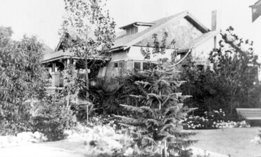 Surrey Hills Historical Society Collection
Photograph, 'Graceburn', 17 Trafalgar Street, Mont Albert
Joseph Arthur Bailey, described as a manager in electoral rolls, came to Surrey Hills some time before 1903. He was born in Brighton in 1873 and died in Burwood in 1929 and is buried in Box Hill Cemetery. He was the son of George Bailey and Georgina Hardwick, who lived in Healesville for a time but 'retired' to Surrey Hills where they are listed at 'Claremont' in Mont Albert Road in 1919. Joseph married Eleanor Beatrice Greenhill in 1897. They had 3 sons - Rupert Aitken (who served in WW1); Kenneth Alan and Edwin George. Prior to living in Trafalgar Street they lived at 9 Victoria Crescent. A black and white photograph of a brick house in the californian bungalow style with a well-established garden, as viewed from one side.trafalgar street, graceburn, house names, 1919, californian bungalow, box hill cemetery, joseph arthur bailey, mrs eleanor beatrice bailey, miss eleanor beatrice greenhill, mr rupert aitken bailey, mr kenneth alan bailey, mr edwin george bailey -
 Kew Historical Society Inc
Plan - Subdivision Plan, J R Mathers & McMillan, Heart of Richmond Estate : Richmond, 1928
"In 1928 the land on the east side of Johnson Street was subdivided in 60 lots for the ‘Heart of Richmond Estate’. The houses in the subdivision, along the east side of Johnson Street, and in the newly created Hollick, Cole and Kennedy streets were constructed from 1928 to 1937." (Source: City of Yarra Heritage Gaps Review One 2013)Portion of subdivision plan pasted on to cardboard. Area includes Johnson Street, Victoria Street, Kennedy Street, Cole Street, Hollick Street, Bennett StreetTitle Certificate Vol.2381, Folio 476130 Phillips, Fox & Masel, 440 Little Collins Street, Melbourne (Local estate agent: Jas. R. Mathers & McMIllan, 136 Cotham Road, Kew)subdivision plans - richmond (vic.), heart of richmond estate -
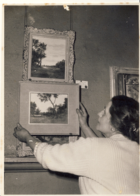 Kew Historical Society Inc
Photograph, The Age, Kew Arts Festival Exhibition, 1944-1951
The Melbourne artist Alma Agnes Marion Figuerola, was the daughter of Juan Pedro Narciso Figuerola (1869-1919) and Alice Lucinda Walker Hanson (1889-1969). Each of their three daughters grew up to be involved in the arts: Alma as a painter; Carmen Irene (1906-1993) as a short story writer, poet and teacher of dancing; and Sylvia (also Silvia) Lyla Alice (1911-1992) as a composer and cellist. The first art lessons Alma Figuerola received were with Oscar Binder. Later she attended the art school established by the Melbourne 'tonalist' [Duncan] Max Meldrum (1875-1955). She graduated from his school in 1920, participating in her first group exhibition in the same year. Solo exhibitions of her work were to be held in 1933 at the Meldrum Gallery in Elizabeth Street, in 1937 and 1945 at the Athenaeum Gallery at 188 Collins Street, and in 1951 at Georges Gallery in Collins Street. Throughout her extensive career she participated in group exhibitions, usually with artists of the Meldrum School, and as a member of the Twenty Melbourne Painters, of which she was invited to become an associate in 1935. In 1953, her portrait of Professor ES Hills was entered in the Archibald Prize Competition of the Art Gallery of New South Wales. A resident of Kew from the 1930s - 51 Studley Park Road, often with her mother, her sister Carmen, or both - from c.1942 until her death she lived at 'D’Estaville', 7 Barry Street. From the late 1930s she is recorded as actively contributing to the arts at a local level. In 1939 and 1940 she participated in art exhibitions at the Hawthorn Municipal Library organised by Jessie Carbines. From 1944 to 1951 she co-organised successive Kew Arts Festivals, initially in the Presbyterian Church Hall in Highbury Grove and later at the Recreation Hall in Wellington Street. A foundation member of the Kew Historical Society in 1958, Alma Figuerola remained an active member of the Society until her death on 8 December 1970. She predeceased her two sisters who both died in the 1990s and who are buried at Andersons' Creek Cemetery in Warrandyte.An undated photograph of Alma Figuerola and an as yet unidentified man hanging paintings for an art exhibition at one of the Kew Arts Festivals held between 1944-51.On reverse, handwritten "4583 Alma Figuerola" Photographer stamp" Copy Right This photograph may not be reproduced without permission in writing from the Editor of "The Age", *** Collins Street, Melbourne, and Pitt Street, Sydney"alma figuerola album, arists - kew (vic), art exhibitions - kew (vic) -
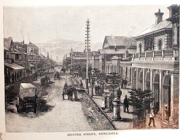 Ballarat Heritage Services
Image, Hunter Street, Newcastle
Streetscape of Hunter Street in Newcastle,hunter street, newcastle, newcastle -
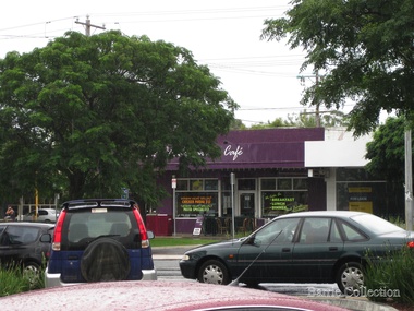 Melton City Libraries
Photograph, High Street, Melton, Unknown
Shops on High Street, Meltonlandscapes of significance -
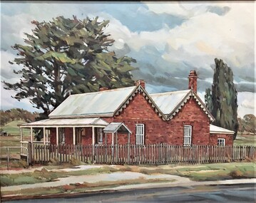 Pyrenees Shire Council
painting, Rodney Read, Avoca Main Street by Rodney Read, 2000
significant as a work of art by local Pyrenees artist, locally significant to the Central Highlands Region of Victoria as a representation of local landscape and/or culture painting of a old house on the streetSigned: R READ 2000 (lower left)