Showing 25599 items matching "plenty-township-estate"
-
 Greensborough Historical Society
Advertising Leaflet, Barry Plant Bundoora, Barry Plant Spring selling season, 2018_08
Spring selling season leaflet with sales results on back of page. 4 Murumba Street Greensborough, sold $1,115,000 ; 11 Sun Orchid Circuit St Helena sold $870,00; 6 Weemala Court Greensborough sold $1,666,000; 6 Howard Street Greensborough sold $737,000; 136 Elder Street Greensborough sold $772,000; 140 Mountain View Road Briar Hill sold $638,000 and 12 Sunrise Drive Greensborough sold 2018 for $1,320,000, previous sales January 1994 $103,000, July 1989 $100,000 and July 1988 $85,500.Real estate advertising leaflet, 1 sheet, printed in colour on both sides.sunrise drive greensborough, murumba street greensborough, sun orchis circuit st helena, elder street greensborough, howard street greensborough, mountain view road briar hill, weemala court greensborough -
 Ringwood and District Historical Society
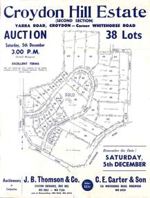
Flyer, Land Auction Sale Advertisement, Croydon Hill Estate, Croydon, Victoria - 1959
Single sided land auction sale advertisement for 38 residential allotments - Croydon Hill Estate (Second Section) Yarra Road, Croydon - corner Whitehorse Road. Auction Saturday, 5th December, and corresponding newspaper advertisement - Ringwood Mail, Thursday, November 26, 1959.Subdivision map includes Richardson Road, Yarra Road, Whitehorse Road, Alice Street, Hull Street (later Mulawa Stret). Auctioneers in Conjunction: J.B. Thomson & Co., Station Entrance, Box Hill, (Telephone) WX 1862, WX 7356, and at Nunawading, WU 1968, WU 3452, and C.E. Carter & Son, 126 Whitehorse Road, Ringwood. WU 6024. -
 Ringwood and District Historical Society
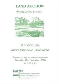
Pamphlet - Land Sales Brochure, Woodlands Estate, Heathmont, 1985
Bifold pamphlet with picture on front, one inside plus plan of Woodlands Road sub division and locality plan on back page. All in green print. Copy enclosed with handwritten sale prices. Auctioneer's notes (Richard Carter) indicate vendor - Estate of Phoebe Beard.Auction on site in a seated marquee, Saturday 14th December, 1985. Agent - C.E. Carter & Son Pty. Ltd., 122 Whitehorse Road, Ringwood, 3134. Telephone 870 6211. -
 Ringwood and District Historical Society
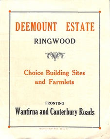
Flyer, Subdivisional Land Sale advertisement - Deemount Estate, Ringwood, Vic. - c.1950
Double sided folded page with black and orange advertisement and blueprint for Deemount Estate fronting Canterbury and Wantirna Roads, Ringwood, with handwritten price list and terms of sale. Additional undated hand-drawn map on light cardboard - 4 allotments on western side of Maidstone Street .Subdivision includes Canterbury Road, Wantirna Road and Maidstone Street. -
 Greensborough Historical Society
Map, Melbourne and Metropolitan Board of Works. Survey Division, MMBW, Yarra 2500 / 13.23. Plenty, Happy Hollow, 1979_03
Melbourne and Metropolitan Board of Works. Yarra 2500 [base map] 13-23. Plenty / Happy Hollow. Parishes of Morang 3183, Nillumbik 3310 and Keelbundora 2856. Municipalities of Diamond Valley 257 and Whittlesea 239. Prominent streets include: McLaughlans Lane and Happy Hollow Drive. Includes Janefield Colony Reserve.MMBW Map in 1:2500 [scale] series. Cream parchment with green tape reinforcing on edges and punched holes on left edge.mmbw, melbourne and metropolitan board of works, shire of diamond valley, plenty - maps, happy hollow -
 Greensborough Historical Society
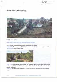
Article and Photograph, Pinehills Estate - Williams Street Greensborough, 2016_
Photographs and captions relating to the Pinehills Estate, Greensborough. This text and photographs were copied from a Facebook site. Members are people who lived in the Greensborough area and share their reminiscences of the area with others. The site is administered by a GHS member but is not officially affiliated with the Society. Any information is the opinion of the contributor. Photographs and text sourced from social media.pinehills estate, pinehills drive greensborough -
 Greensborough Historical Society
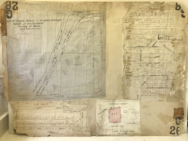
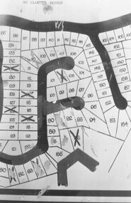
Planning document, City of Heidelberg, Subdivision Plan # G26. Grace Park Estate Greensborough, 1950c
Plan of Subdivision (G26). Grace Park Estate. An example of hard copy subdivision plans from the Greensborough area. From Shire of Heidelberg.Plan mounted on heavy card.Stamped and handwritten Council permissions, dates and other details.subdivision plans, grace park -
 Stawell Historical Society Inc
Photograph, Griffin Family Photo Album -- From estate of Marlene Griffin
Griffin Album. From estate of Marlene Griffin.stawell -
 Ringwood and District Historical Society
Photograph, Byways Estate, Ringwood East, June 1965 (2 views)
Written on backing sheets (2 photos), "Byways Estate, Ringwood East, June 1965. C.E. Carter, agent. Prices 1850-2950 pounds, 33 lots. Byways Drive - Rex Court and Buronga Avenue". -
 Eltham District Historical Society Inc
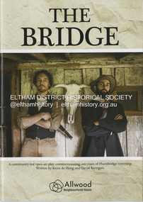
Booklet - Program, Keira de Hoog et al, The Bridge; a community-led open play commemorating 100 years of Hurstbridge township, September 2024
Program produced as part of the open air play peformed in Hurstbridge twice on the 4th and 12th of October 2024. Contents include: Allwood history - Allwood today - Construction of The Bridge - Cast - Synopsis - Directors - Crew - Hearfelt thanks and tribute to Pam Lawson. The Premiere of the open air play The Bridge performance at Hurstbridge was by members of the Allwood Neighbourhood House and the Hurstbridge Community. To commemorate 100 years of Hurstbridge township, the production was led by local historian David Kerrigan who co-wrote the play with Keira de Hoog. The quiet life of the Diamond Creek district was shattered on the 4th October 1866 when a visitor arrived seeking food and shelter. What followed has become part of the Hurstbridge story. The death of Henry Hurst by the bushranger Robert Burke and the subsequent inquest, trial and execution of Burke captured the attention of the nation. News of the event was reported nationally and in UK newspapers. Rain at sunset on opening night set the scene for the sombre story which opened with clap sticks and imagery as part of the acknowledgement of country. Attention to detail in Act One included the enactment of writing a letter that Ellen Hurst had actually written back to her family in England, days before the incident, which set the scene – and choreography of the “capture” of Burke immediately following the shooting as drawn by the engraver Robert Bruce and published in 1866. The cast, crew and audience moved around the actual physical site the altercation took place till the final act and judgement of Sir Redmond Barry to execute Burke. The souvenir program given to ticket holders includes photos and biographies of the cast taken in costume at Gulf Station, Yarra Glen, together with background information and the narrative of the play. Guests on opening night – 158 years ago to the day of the event included Dianne Switzer, descendent of pioneer Cornelius Hailley and Rob Fergusson, descendent of Henry Hurst. plays, hurstbridge, allwood neighbourhood house -
Phillip Island and District Historical Society Inc.
Newspaper clippings
Newspaper clipping on early history of San Remo and district, the naming of the township, San Remo Heights Estate Hall and the San Remo Post Office.Early history of San Remo, including its original settlement, surveying of the district, change of name from Griffiths Point proclaimed in the Victorian Government Gazette on 11th august, 1888. also early history of San Remo Heights Estate Hall and the San Remo Post Office. Includes a photograph of the township and fishing fleet probably taken from 1940 bridge.local history, documents, newspapers, san remo, buildings - historical, black & white newspaper clipping, san remo, post office, fishing fleet -
 Whitehorse Historical Society Inc.
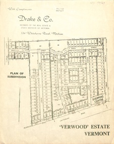
Document, Verwood Estate, Vermont
A subdivision plan of 'Verwood Estate', Vermontnon-fictionA subdivision plan of 'Verwood Estate', Vermontverwood estate vermont, drake real estate, drake co -
 Orbost & District Historical Society
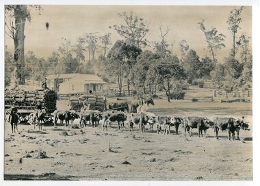
black and white photograph, 1889
This photograph shows a large bullock team at the foot (eastern side?) of the Orbost township.This is a pictorial record of transport used in the late 19th century in Orbost.A large black / white photograph of a bullock team pulling a laden cart. A man is sitting on top of the freight. In the background is a horse - drawn cart loaded with sacks (maize?) with a man on a horse to the side and another standing on the shafts. In the foreground are two men on horses. There is a small house and barn in the background.on back - " At the foot of the township - 1889"orbost transport-bullock-teams horse-drawn-transport -
 Greensborough Historical Society
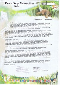
Newsletter, Plenty Gorge Metropolitan Park Newsheet No. 1 August 1989, 1989_08
The Shire of Whittlesea obtained a grant from the federal government to investigate the potential development of a park to the west of the Plenty River in 1976. A regional tip site and the Shire of Diamond Valley's Yarrambat Park were handed over to the MMBW to form the existing Metropolitan Park in 1986. A long term project to develop the park further is to commence in 1990.2 p. text, map and col. illus."With compliments of Sherryl Garbutt M.P. Member for Greensborough" (rubber stamp)plenty gorge park -
Greensborough Historical Society
Article, Ian Lamont, An early history of Plenty Valley FM Radio 1987-1998, 1987o
Plenty Valley FM made its first test broadcast in July 1988, then known as Outer North Eastern Community Radio. After obtaining its broadcasting licence, regular broadcasts commenced in December 1990. The author of this article, Ian Lamont, was first Station President (1987-91) and first Station Manager (1993-98).3 pages text and one photo.plenty valley community radio, plenty valley fm, ian lamont -
 Eltham District Historical Society Inc
Audio - Audio Compact Disc, Marie Ryan, Mick Woiwod, Andrew Ross Museum with Marie Ryan on Magazine, Plenty Valley FM Radio, 21 July 2005
Mick Woiwod of the Andrew Ross Musuem, Kangaroio Ground, speaking with host Marie Ryan of Magazine, on Plenty Valley FM Radio talking about his latest book, "Golden Days on the Caledonian Diggings; the diaries of Thomas Young of Kangaroo Ground, Panton Hill and Christmas Hills." Also discussing some activities at the Andrew Ross Museum.audio recording, mick woiwod, andrew ross museum, thomas young, kangaroo ground, panton hill, christmas hills, caledonia mine, gold mining -
 Kew Historical Society Inc
Plan - Subdivision Plan, Old Kew Golf Links Estate - Third Section, 1920-1929
Pru Sanderson, in her groundbreaking ‘City of Kew Urban Conservation Study : Volume 2 - Development History’ (1988), summarised the periods of urban development and subdivisions of land in Kew. The periods that she identified included 1845-1880, 1880-1893, 1893-1921, 1921-1933, 1933-1943, and Post-War Development. These periods were selected as they represented periods of rapid growth or decline in urban development. An obvious starting point for Sanderson’s groupings involved population growth and the associated economic cycles. These cycles also highlighted urban expansion onto land that was predominantly rural, although in other cases it represented the decline and breakup of large estates. A number of the plans in the Kew Historical Society’s collection can also be found in other collections, such as those of the State Library of Victoria and the Boroondara Library Service. A number are however unique to the collection.The Kew Historical Society collection includes almost 100 subdivision plans pertaining to suburbs of the City of Melbourne. Most of these are of Kew, Kew East or Studley Park, although a smaller number are plans of Camberwell, Deepdene, Balwyn and Hawthorn. It is believed that the majority of the plans were gifted to the Society by persons connected with the real estate firm - J. R. Mathers and McMillan, 136 Cotham Road, Kew. The Plans in the collection are rarely in pristine form, being working plans on which the agent would write notes and record lots sold and the prices of these. The subdivision plans are historically significant examples of the growth of urban Melbourne from the beginning of the 20th Century up until the 1980s. A number of the plans are double-sided and often include a photograph on the reverse. A number of the latter are by noted photographers such as J.E. Barnes.When the old Kew Golf Links was subdivided in the mid 1920s, the developers were able to break the sale into sections. The third section included eighty lots. The lots faced Kilby Road, Kodak Avenue, Belford Road, Baker Avenue, Mathers Avenue, and White Avenue. [Kodak Avenue was renamed Page Avenue at a later date].The ‘Kew Conservation Study (1988) notes that ‘On the subdivision plan, Kodak’s involvement is commemorated by the naming of the streets after Company directors, and their decision to not proceed with the construction of the factory is explained as a response to the increase in the value of the land. This explanation may have been Estate Agent’s hyperbole, as the Kodak Company records suggest that the land, with its wide creek gully, was unsuitable and too small for its purposes.subdivision plans - kew, old kew golf links estate - third section -
 Kew Historical Society Inc
Plan - Subdivision Plan, Belford Heights Estate, Kew, ca. 1925
Pru Sanderson, in her groundbreaking ‘City of Kew Urban Conservation Study : Volume 2 - Development History’ (1988), summarised the periods of urban development and subdivisions of land in Kew. The periods that she identified included 1845-1880, 1880-1893, 1893-1921, 1921-1933, 1933-1943, and Post-War Development. These periods were selected as they represented periods of rapid growth or decline in urban development. An obvious starting point for Sanderson’s groupings involved population growth and the associated economic cycles. These cycles also highlighted urban expansion onto land that was predominantly rural, although in other cases it represented the decline and breakup of large estates. A number of the plans in the Kew Historical Society’s collection can also be found in other collections, such as those of the State Library of Victoria and the Boroondara Library Service. A number are however unique to the collection.The Kew Historical Society collection includes almost 100 subdivision plans pertaining to suburbs of the City of Melbourne. Most of these are of Kew, Kew East or Studley Park, although a smaller number are plans of Camberwell, Deepdene, Balwyn and Hawthorn. It is believed that the majority of the plans were gifted to the Society by persons connected with the real estate firm - J. R. Mathers and McMillan, 136 Cotham Road, Kew. The Plans in the collection are rarely in pristine form, being working plans on which the agent would write notes and record lots sold and the prices of these. The subdivision plans are historically significant examples of the growth of urban Melbourne from the beginning of the 20th Century up until the 1980s. A number of the plans are double-sided and often include a photograph on the reverse. A number of the latter are by noted photographers such as J.E. Barnes.The Belford Heights Estate was a subdivision in Kew East, even though the title of the plan indicates that it was located in Kew. The subdivision had been approved by 1915, and included 105 lots facing Strathalbyn, Kitchener, Hamilton and Beresford Streets, as well as Balfour and Belford Roads. Those lots hand coloured with red probably represent blocks that had been sold. The additional information provided on the plan is also of interest. The plan includes the original location of East Kew State (Primary) School in Strathalbyn Street, which opened in 1892. The inset Locality Plan also includes the route of the Outer Circle Railway and the location of the Wilsmere and East Kew Stations. The location of the landmark Harp of Erin Hotel is also marked on the Locality Plan.belford heights estate, subdivision plans - kew -
 Kew Historical Society Inc
Plan - Subdivision Plan, Jas R Mathers Son & McMillan, The Dale Estate, Deepdene, 1918
Pru Sanderson, in her groundbreaking ‘City of Kew Urban Conservation Study : Volume 2 - Development History’ (1988), summarised the periods of urban development and subdivisions of land in Kew. The periods that she identified included 1845-1880, 1880-1893, 1893-1921, 1921-1933, 1933-1943, and Post-War Development. These periods were selected as they represented periods of rapid growth or decline in urban development. An obvious starting point for Sanderson’s groupings involved population growth and the associated economic cycles. These cycles also highlighted urban expansion onto land that was predominantly rural, although in other cases it represented the decline and breakup of large estates. A number of the plans in the Kew Historical Society’s collection can also be found in other collections, such as those of the State Library of Victoria and the Boroondara Library Service. A number are however unique to the collection.The Kew Historical Society collection includes almost 100 subdivision plans pertaining to suburbs of the City of Melbourne. Most of these are of Kew, Kew East or Studley Park, although a smaller number are plans of Camberwell, Deepdene, Balwyn and Hawthorn. It is believed that the majority of the plans were gifted to the Society by persons connected with the real estate firm - J. R. Mathers and McMillan, 136 Cotham Road, Kew. The Plans in the collection are rarely in pristine form, being working plans on which the agent would write notes and record lots sold and the prices of these. The subdivision plans are historically significant examples of the growth of urban Melbourne from the beginning of the 20th Century up until the 1980s. A number of the plans are double-sided and often include a photograph on the reverse. A number of the latter are by noted photographers such as J.E. Barnes.The Dale Estate in Deepdene was made possible by the death of Robert Sparrow Smythe, Australian journalist, newspaper editor/owner and theatrical manager. Smythe lived in his residence ‘Highate’, Deepdene until his death in 1917. In the subdivision proposed one year later, before the end of the First World War, 18 allotments were to be created. The very fragmentary plan in the Society’s collection notes that a large weatherboard [house] will need to be removed. This may be Smythe’s own home. The proposed subdivision included allotments facing Burke and Whitehorse Roads and Dale Street. Bordering the subdivision is the Deepdene Station and the Outer Circle Railway Line. The clear directions on the plan indicate that in 1918 it was possible to travel by train from Deepdene to East Camberwell and Ashburtonsubdivision plans - deepdene, the dale estate -
 Whitehorse Historical Society Inc.
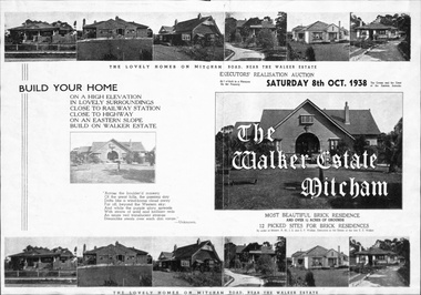
Document, Walker Estate, 1/10/1938
Brochure for auction, 8 October 1938 of Walker Estate, Mitcham. 9 room brick residence and 11/2 acres of grounds, subdivided into 12 building sites for brick residences. House built for E.E. Walker by Louis Hatherley. Auctioneers: Edward Haughton Pty Ltd and Drake & Co.land subdivision, walker estate, walker, edgar edwardes, hatherley, louis, meerut street, mitcham, mitcham road, agra street, simla street -
Glen Eira Historical Society
Letter - Ristori Estate, Lots 20 and 21
11 documents about the sales (31/05/1919 initially; then March 1920) of Lots 20 and 21 Ristori Estate: 1/3 contracts of sale to Edwin Percy Smith from ME Coppel. 2/2 receipts from Yeo Crosthwaite & Co. to E.P. Smith dated 26/11/1919 and 24/02/1920 for quarterly payments. 3/1 working copy of contract of sale dated March 1920 from E.P.Smith to Thomas Herbert Evans Putt. 4/1 handwritten letter dated 09/08/1920 from E.P. Smith to Mr P. St John Hall Esq asking for advice about transfer papers for the Ristori Estate. 5/1 typed letter dated 16/08/1920 from Yeo Crosthwaite & Co to E.P. Smith asking for signing return of Alienation Notice. 6/1 handwritten letter dated 23/08/1920 from E.P. Smith to Mr P. St John Hall asking whether he or Mr Putt should sign papers. 7/1 typed letter dated 07/09/1920 from Yeo Crosthwaite & Co. to E.P. Smith asking for return of Land Tax Alienation Notice. 8/1 handwritten note dated 18/09/1920 from (likely) Mr Putt to Yeo Crosthwaite & Co returning Land Tax Notice & further Notice of Sale; 9/Business Card (handwritten) for Thomas Herbert & Evan Putt, Builder, Inkerman Road, Caulfieldripponlea, smith edwin percy, inkerman road, ristori estate, glenhuntly rd, glen huntly road, correspondence, auctions, putt thomas herbert evans, builders, yeo crosthwaite & co., receipts, elsternwick, coppel m.e, auctioneers -
 Greensborough Historical Society
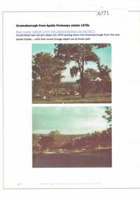
Article and Photograph, Greensborough from Apollo Parkways estate 1970, 2016_
Information and photos of Greensborough and the Apollo Parkways estate in October 1970.This photograph and text was copied from a Facebook site. Members are people who lived in the Greensborough area and share their reminiscences of the area with others. The site is administered by a GHS member but is not officially affiliated with the Society. Any information is the opinion of the contributor. Article and photograph sourced from social media.greensborough, apollo parkways -
 Ringwood and District Historical Society
Photograph, Plan of Lots in Bel-Air Estate 1991
4 photographs of sections of the plans.a. Written on back of photograph, "20/6/81. Plan of Bel Air Estate. Werac Drive runs down left side of plan. Kubis Drive crosses top. Debbie Place drops down from Kubis. Manuela Tce. runs right from Werac, ends at a bend and becomes Rudolf Court running North. Lyn Court takes off right from Rudolf and Burlock Ave. touches estate with an elbow" b. Written on back of photograph, "20/6/81. Plan of lots in Bel Air Estate. Glenvale Road down left side of plan, Kubis Dr. Runs across picture. June Square drops from and Jenken Close rises form Kubis Dr. Werac Dr. drops to bottom of picture and Manuella takes off to right". d. Written on back of photograph, "20/6/91. Lots in Bel-Air Estate. Kubis Dr. rises from bottom left to Oban Road top. Pamela Crt. drops from Kubis at left, Iluka Crt. takes off right. Whitlam Dr. runs left at top and Menzies Cr. drops off it to centre of picture". c. Written on back of photograph, "20/6/81. Plan of lots on Bel-Air Estate. Kubis Dr., Debbie Place, Pamela Crt, Iluka Crt. Menzies Drive" -
 Whitehorse Historical Society Inc.
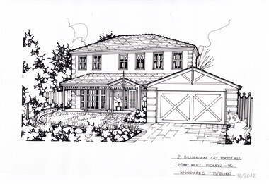
Artwork, other - Ink Line Drawing, Margaret Picken, 2 Silverleaf Crt., Forest Hill, 1996
A property illustration by Margaret Picken Commissioned by the real estate agency Woodards Real Estate Blackburn for the purpose of advertising 2 Silverleaf Crt., Forest Hill. Made by using Rotring ‘Rapidigraph’ drafting pens with Rotring ink on Rapidigraph polyester drafting film, double matte. Trained as a cartographic draftsman within the mining industry, Margaret Picken is an artist who worked producing property illustrations for real estate agencies in eastern suburbs of Victoria from 1983-2005. Retiring from the industry as technological changes favored coloured photography over illustrations, and commissioning companies over sole contractors.This artwork is of Historical Significance as a record of local domestic architecture.A black ink line drawing on drafters film by Margaret Picken, of 2 Silverleaf Crt., Forest Hill, of a two story rendered house setback from a landscaped front garden, with a attached two car garage. There are two hole punch holes near the centre of the upper edge.2 Silverleaf Crt., Forest Hill Picken - 96 Woodards - B/burnwhitehorse historical society, schwerkolt cottage, housing, architecture, margaret picken, house, garden, forest hill, real estate -
 Greensborough Historical Society
Leaflet, Jellis Craig, 2017_
Advertising leaflet for Jellis Craig, Real Estate. Their shop front is at 4/94-96 Grimshaw Street.1 page, double-sided colour leafletreal estate agents, jellis craig -
 Kew Historical Society Inc
Plan - Subdivision Plan, Erin Heights Estate, East kew, 1917
Pru Sanderson, in her groundbreaking ‘City of Kew Urban Conservation Study : Volume 2 - Development History’ (1988), summarised the periods of urban development and subdivisions of land in Kew. The periods that she identified included 1845-1880, 1880-1893, 1893-1921, 1921-1933, 1933-1943, and Post-War Development. These periods were selected as they represented periods of rapid growth or decline in urban development. An obvious starting point for Sanderson’s groupings involved population growth and the associated economic cycles. These cycles also highlighted urban expansion onto land that was predominantly rural, although in other cases it represented the decline and breakup of large estates. A number of the plans in the Kew Historical Society’s collection can also be found in other collections, such as those of the State Library of Victoria and the Boroondara Library Service. A number are however unique to the collection.The Kew Historical Society collection includes almost 100 subdivision plans pertaining to suburbs of the City of Melbourne. Most of these are of Kew, Kew East or Studley Park, although a smaller number are plans of Camberwell, Deepdene, Balwyn and Hawthorn. It is believed that the majority of the plans were gifted to the Society by persons connected with the real estate firm - J. R. Mathers and McMillan, 136 Cotham Road, Kew. The Plans in the collection are rarely in pristine form, being working plans on which the agent would write notes and record lots sold and the prices of these. The subdivision plans are historically significant examples of the growth of urban Melbourne from the beginning of the 20th Century up until the 1980s. A number of the plans are double-sided and often include a photograph on the reverse. A number of the latter are by noted photographers such as J.E. Barnes.The Erin Heights Estate in Kew included just seven lots in in Valerie Street. These were all that remained of this wartime subdivision, the other 11 allotments on Balfour and Belford Roads having already been sold. Balfour Road was to be only a temporary name as the street is currently called Windella Avenue. Now, the parkland opposite the subdivision is the reserve created from the route of the Outer Circle Railway. This Railway reached Kew East in 1925, but had been planned as far back as 1873. The development focuses on the benefits of living in Kew: being at the highest of Kew’s ‘suburbs’; being a good residential area; its rapid growth; and the proximity of the Kew East tram in High Street. In 1917, the electric tramline only extended to a terminus at the Harp of Erin hotel. The terminus is clearly represented on the plan.subdivision plans - east kew, erin heights estate -
 Greensborough Historical Society
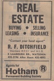
Advertisement - Digital image, Diamond Valley News, Ditchfield Real Estate, Watsonia, 1973, 21/08/1973
Advertisement for Ditchfield Real Estate, 2 Lambourn Road, Watsonia,1973.Digital copy of newspaper advertisement.ditchfield real estate, lambourn road watsonia -
 Greensborough Historical Society
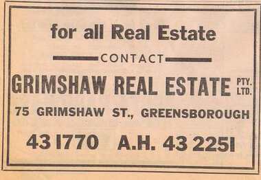
Advertisement - Digital image, Diamond Valley News, Grimshaw Real Estate, 1964, 29/09/1964
Advertisement for Grimshaw Real Estate, 75 Grimshaw Street, Greensborough 1964Digital copy of newspaper advertisement.grimshaw street greensborough, grimshaw real estate -
Malmsbury Historical Society
Photograph (Item), House In Tucker St C1990 Real Estate Photo, Malmsbury c1990
Buildings - House Associated with - "Real Estate Agent, Kyneton Hist Soc" -
Malmsbury Historical Society
Photograph (Item), "House In Malmsbury C1990, Real Estate Photo, Sold", Malmsbury c1990
Buildings - House Associated with - "Real Estate Agent, Kyneton Hist Soc"