Showing 4473 items
matching the point
-
 Glenelg Shire Council Cultural Collection
Photograph - Sheet of 12 contact prints - Various historic Portland buildings and Landmarks, c. 1970
Sheet of 12 contact prints of rephotographed photographs. Identifying numbers 5724 a, b, c, d, e, f, g, h, i, j, k, l (a) First jetty and immigration depot (b) National School (c) Observatory Hill (d) 'Kenley" Res. George Crouch, First Post Master (e) Old Library (f) Union (ANZ) Bank (g) Lighthouse and Keepers Cottage (h) 'Blainslie' (i) View from Whalers Bluff over Bay (j) Percy Street, view from Henty Street (k) Portland Jail (l) Flagstaff and Light Keepers quartersFront: (a) Henty Beach (b) Portland State School (c) Old Library (f) ANZ Bank (i) View of Whalers Point (k) Portland Jail on Observatory Hill -
 Queenscliffe Maritime Museum
Photograph - Photo of Old Signal Station Pt Lonsdale, Photo of Pt Lonsdale Signal Station, unknown
Pt Lonsdale signal stationSignal stationBlack & white photo of Old Signal Station Pt LonsdaleReverse " old signal station / Point Lonsdale / before 1950 / when base of l'house altered to providean observation & shipping controlroom as part of a signal station / G B Ferrier "historical references -
 Port Fairy Historical Society Museum and Archives
Photograph
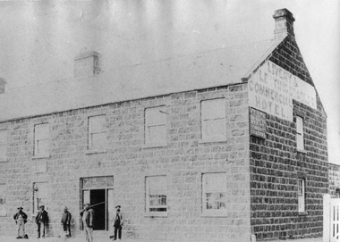
John J. Huntly appears to have been the only licensee of the Royal Oak Hotel, built in 1858. Commercial Hotel Bank Street Port Fairy Formerly known as The Royal Oak and then renamed The Royal Oak in the 1990's. A verandah was added in 1900. Around 1877 the hotel various rooms for visiting doctors and a dentist. Dr Berncastle who was associated with the Sydney Eye Infirmary performed several operations there on those suffering from cataracts. It was the meeting place for the Port Fairy Freemasons, before their lodge was built in James Street and all local sporting clubs at one time or another. Also a Cobb & Co staging post.Large Black and white Photograph of the Commercial Hotel Left hand top corner in Ball point pen- PRESENTED BY MR RON McLEAN Right hand top corner in pen - COMMERCIAL HOTEL Museum Number - 62.04B.012hotel, bank street, port fairy, doctor berncastle, commercial, royal oak, sydney eye infirmary, freemasons, lodge, cobb and co, livery stables -
 The Beechworth Burke Museum
Photograph - Stereoscopic Photograph
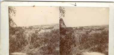
This photograph offers a view of Beechworth, located at the foot of the Victorian Alps. It captures the gorge and native vegetation in the foreground, with the Beechworth township visible in the middle, where the hospital is marked with an arrow. Distant hills form the backdrop. Originally settled c1839, Beechworth was officially proclaimed a town in 1856.This photograph is historically significant as it captures the landscape of Beechworth, providing valuable insight into the town's visual and historical character.Two sepia-toned square photographs showing the view of a town with trees in the foreground and hills in the far distance, mounted.Obervse: Above the right photograph there is an arrow pointing down. Reverse: 97.2195/ View across the Gorge/ looking over Beechworth/ (Hospital under arrow)/ 84-110-1/ A03082beechworth, town, landscape, ovens district, stereoscopic -
 Flagstaff Hill Maritime Museum and Village
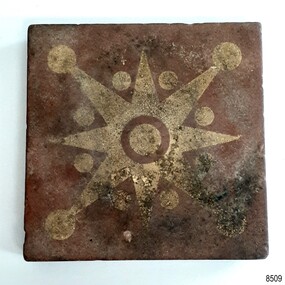
Ceramic - Floor Tile, Maw & Co, 1862-1869
The floor tile is one of a group of artefacts in the McCulloch Collection that were recovered from the shipwreck Victoria Tower and were donated together. The tile could have been from the ship's cargo or amongst a ship’s fittings. The inscription on the tile is for Maw & Co makers of earthenware encaustic and geometric floor tiles since 1850, when George Maw and his brother Arthur began their first factory in Worcester. In 1862 the company moved to Broseley, Shropshire. The object is now one of the shipwreck artefacts in Flagstaff Hill’s Mc Culloch Collection, which includes items recovered from the wrecks of the Victoria Tower (wrecked in 1869) and Loch Ard (wrecked in 1878). They were salvaged by a diver in the early 1970s from the southwest coast of Victoria. Advanced marine technology had enabled divers to explore the depths of the ocean and gather its treasures before protective legislation was introduced by the Government. The artefacts were donated to Queensland’s Department of Environment and Heritage Protection (EHP) by a passionate shipwreck lover and their locations were verified by Bruce McCulloch. In 2017 the Department repatriated them to Flagstaff Hill where they joined our vast collection of artefacts from Victoria’s Shipwreck Coast. The Victoria Tower: - The three-masted iron clipper ship was built in 1869 in Liverpool, England, as a passenger and cargo ship for the Australian trade. She was named after one of the two towers of the British Houses of Parliament and owned by the White Star line. The Victoria Tower sailed under the command of Captain Kerr from Liverpool towards Melbourne on her maiden voyage. She carried 34 passengers and 16 crew plus a general cargo including bottled beer, slates, iron pipes and hardware. She was almost at her destination when she was wrecked on 17th October 1869 at Point Impossible, west of Thompsons Creek, Breamlea. The shipwreck is a very popular diving site. The artefact has now been repatriated to Victoria and is located at Flagstaff Hill Maritime Village. The artefact is an example of cargo or personal items on board a ship in 1869. It provides a reference point for classifying and dating similar items. The artefact is significant for its association with the clipper ship Victoria Tower, which is listed on the Victorian Heritage Register as S698. The Victoria Tower is recorded as the most intact historic shipwreck accessible between Point Lonsdale and Cape Otway. The Victoria Tower is one of only seven shipwrecks in Victoria that have had more than 100 objects recovered from them reported as a result of the Commonwealth Amnesty held in 1993-94.Ceramic tile, square, with star or compass design.Brown tile has cream design of i-pointed star with a circle in the centre and between, and on the end of, each point. The side profile of the tile shows the division between the top layer and the base, with a groove between the two. The tile was made by MAW & Co. of Broseley, England. The back of the tile has parallel ridges and is embossed with an inscription. It was recovered from the wrecked ship Victoria Tower. Inscribed "MAW & CO BROSELEY" flagstaff hill, warrnambool, maritime village, maritime museum, flagstaff hill maritime museum and village, shipwreck coast, great ocean road, shipwreck artefact, wreck dive, mcculloch collection, bruce mcculloch, white star line, victorian heritage register, clipper ship, victoria tower, captain kerr, shipwreck victoria tower, migrant ship 1869, cargo ship 1869, iron clipper, british clipper ship, 1869, cargo imported to australia, tile, floor tile, ceramic tile, compass pattern, star pattern, flooring -
 Bendigo Historical Society Inc.
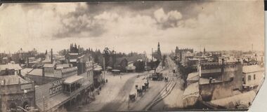
Photograph - CARWARDINE COLLECTION: STREETVIEW CHARING CROSS AND VIEW POINT, BENDIGO
Black and white photo. Image shows Charing Cross and View Point, looking northwards up Pall Mall (taken from City Family Hotel?) View Point businesses evident are : National and Mutual Life; A.M. Armstrong newsagents with 'The Argus popular daily ' on front; Moran and Cato, Warren's View Point Hotel, with two storey veranda ( on side: Cameo Cigarettes). Tram in foreground in View Street approaching fountain. Hustler's Royal Reserve poppet head and chimney on western side of Pall Mall, smoke rising from engine house? Post Office building with clock tower in distance. On RH side of image: written on verandah, Woodrow's Southern Cross Hotel; E.L. Holdsworth Chemist and Shamrock Hotel in distance. Four horse drawn taxis in centre of Charing Cross roadway, near fountain. Receipt number 355/16bendigo, business, carwardine soap and candle -
 Federation University Historical Collection
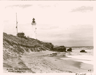
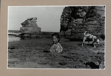
Photograph - Photograph - Black and White, Point Lonsdale, Victoria; Back Beach below the Lighthouse - Girl with a Dog
Work produced during Paul Lambeth's photography class The photograph shows the back beach at Point Lonsdale, below the Point Lonsdale Lighthouse. This area was where many sailing ship coming to Melbourne were wrecked. This was due to the narrow passage through The Rip and the tides at certain times. A Pilot Station was established and ship captains could signal for a Pilot to steer them through The Rip and into Port Philip Bay. Black and white photograph adhered to a beige coloured mount card showing a girl down a hole in the sand with her dalmation dog sitting in a rock pool.paul lambeth, point lonsdale, back beach, sailing ships, ship wrecks, the rip, port philip bay, pilot station, girl, dalmation dog -
Queenscliffe Maritime Museum
Uniform - Uniform, commando
Equipment similar to that worn by commandos involved in Rip Disaster. On the evening of February 17, 1960, 74 peacetime commandos in army boats set off on a training exercise from Point Lonsdale to Point Nepean, simulating a raid. Swept out to sea through The Rip as they crossed the bay from Point Lonsdale, George ''Taffy'' Drakopoulos and Eddie Meyer drowned before they could be rescued. Another man, Roger Wood, selflessly helped his fellow commandos up a rope ladder to safety from a Zodiac inflatable, only to be flung off the end into an angry sea somewhere beyond The Rip. The three dead men were all from Melbourne, all aged around 20.Lifeboat Queenscliff assisted in the search for the lost commandos in February 1960Army commando webbing belt and pair of gaiterswebbing, uniform, commandos, rip disaster -
 Lorne Historical Society
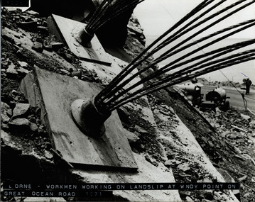
Photograph, Landslip Great Ocean Road 1971
Repairing land-slip at Windy-Point, showing cables that secured the face of the cliff. These cables ends are cut off and a concrete slab placed over the plate. Working machine below on the G.O.R. and workman holding stop/go sign.land-slip 1971: windy-point; cable-locks. concrete securing blocks. maintenance equipment -
Glenelg Shire Council Cultural Collection
Photograph - Photograph - Portland Harbour, 1930s
Black and white photo, white border. View of the Harbour, Portland, from clifftop, looking east. Baths, Ocean Pier, Railway Pier, Fishermen's Breakwater, Battery Point in background. 'THE HARBOUR, PORTLAND', black print, lower border -
Glenelg Shire Council Cultural Collection
Clothing - Tie, c. 1996
PArt of the Glenelg Shire Council uniformMen's tie, woven and manufactured in Australia with original Glenelg Shire Logo. Tie is navy blue with red, blue green diagonal stripes and GSC logo embroidered in red and green at the wider point end. In original plastic packaginguniform, civilian, tie, male clothing -
Glenelg Shire Council Cultural Collection
Postcard - Postcard - Portland, Victoria, n.d
Two black and white Magnus photo postcards. a. Portland from the railway bridge, looking towards old Post Office. b. Portland from Piles' Hill (Battery Point) looking towards All Saints Catholic Church.postcard, portland, tourism, travel -
Glenelg Shire Council Cultural Collection
Photograph - Photograph - Main Breakwater construction, Portland, 31/05/1957
Port of Portland Authority ArchivesBack: 31.5.57port of portland archives, main breakwater construction, harbour development -
Glenelg Shire Council Cultural Collection
Photograph - Photograph - Main Breakwater construction, Portland, n.d
Port of Portland Archivesport of portland archives, main breakwater, construction, harbour -
 Bendigo Historical Society Inc.
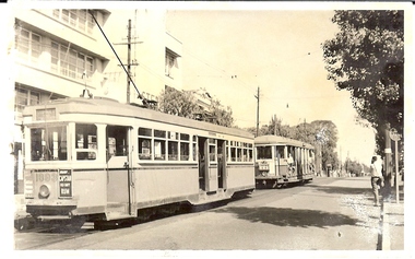
Photograph - BASIL MILLER COLLECTION: SYDNEY TRAMS
Black and white photograph of Sydney trams. Inscriptions on reverse: Point on last day of tramway services 22/11/1958. In blue ink Rozelle & GeorgeSt. Lines. 'R' & 'O' type cars. Number '913' written in pencil.person, individual, basil miller -
 Bendigo Historical Society Inc.
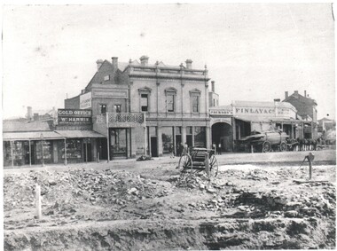
Photograph - WES HARRY COLLECTION: VIEW POINT, 1861
Black and white photograph of View Point Sandhurst. Some of the businesses shown are :- William Harris, medical Dispensary, Gold Office, Medical Hall, Oriental Bank Corporation, Jackson's Iron Yard, Findlay and Co. Batchelder cart in foreground.Batchelderplace, bendigo, view point, sandhurst, view point, w. harris medical dispensary. gold office, oriental bank corporation, jackson's iron yard, finlay and co. -
 Bendigo Historical Society Inc.
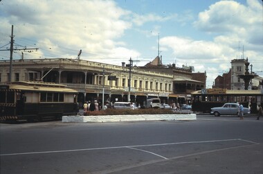
Slide - BENDIGO STREET VIEWS & FORTUNA, Jan 1964
Slide. Bendigo Street Views & Fortuna. A view of View Point, Charring Cross, with the City Club Hotel on the left, the City Family Hotel on the right, two trams and some cars. No traffic lights, buildings still have verandas.slide, bendigo, bendigo street views & fortuna., bendigo street views & fortuna. -
 Anglesea and District Historical Society
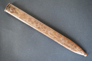
Scabbard, Estimated 1916
Metal sheath with a screw just below the throat and a hook or stud to facilitate wearing the sword. The blade's (absent) point is further protected by a metal extension called a drag or shoe. Brownish in colour. Has a large dent on one side.None.scabbard, sheath for sword, bayonet, german -
 Northern District School of Nursing. Managed by Bendigo Historical Society Inc.
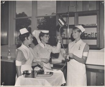
Photograph - Training
Training Prac - Preparing for a bowel washout - Sr Joan Sidaway Nurses Robyn Powis Jill RobinsonBlack and White photo - Two Nurses standing either side on a Tutor(Nursing Sister)who is pointing to the top of a frame with a metal object attached to a tube which is being held by one of the two nurses. Preparing for bowel washout .Names on back of photonurse training, nurses uniform, nursing information -
 Ballarat Tramway Museum
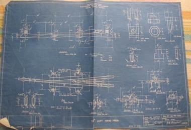
Drawing, State Electricity Commission of Victoria (SECV), "Geelong – 7 1/2o left hand frog", 1943
Used in tramway power supply overhead.Yields information about the details of a the point frog used in the overhead in Geelong. Similar equipment used in Ballarat and Bendigo.Blueprint of SEC drawing No. GE-T6-7380 "Geelong – 7 1/2o left-hand frog", dated 31/1/1943. Details of a the point frog used in the overhead in Geelong. Similar equipment used in Ballarat and Bendigo.Has “107” in biro in top right hand corner. Has "Recorded in Drawing" office stamp on rear.overhead, trolley wire, equipment -
 Bendigo Historical Society Inc.
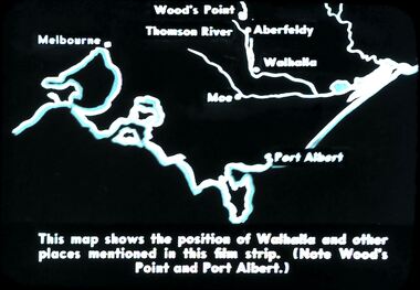
Slide - DIGGERS & MINING. DIGGERS AND MINERS, c1850s
Diggers & Mining. Diggers and miners. Walhalla - Gold Town. This map shows the position of Walhalla and other places mentioned in this film strip. (Note Wood's Point and Port Albert.) Markings: 6 995 WAL. Used as a teaching aid.hanimounteducation, tertiary, goldfields -
![Cumberland Creek, near Point Sturt / [by] Nicholas Caire, circa 1876](/media/collectors/550653872162f11fb04854aa/items/57834713d0cdd1176c71111b/item-media/57834799d0cdd1176c71e113/item-fit-380x285.jpg) Kew Historical Society Inc
Kew Historical Society IncPhotograph, Anglo-Australasian Photographic Company, Cumberland Creek, near Point Sturt, c. 1876
Nicholas Caire was born on Guernsey in the Channel Islands in 1837. He arrived in Adelaide with his parents in about 1860. In 1867, following photographic journeys in Gippsland, he opened a studio in Adelaide. From 1870 to 1876 he lived and worked in Talbot in Central Victoria. In 1876 he purchased T. F. Chuck's studios in the Royal Arcade Melbourne. In 1885, following the introduction of dry plate photography, he began a series of landscape series, which were commercially successful. As a photographer, he travelled extensively through Victoria, photographing places few of his contemporaries had previously seen. He died in 1918. Reference: Jack Cato, 'Caire, Nicholas John (1837–1918)', Australian Dictionary of Biography.An original, rare photograph from the series 'Views of Victoria: General Series' by the photographer, Nicholas Caire (1837-1918). The 60 photographs that comprise the series were issued c. 1876 and reinforced a neo-Romantic view of the Australian landscape to which a growing nationalist movement would respond. Nicholas Caire was active as a photographer in Australia from 1858 until his death in 1918. His vision of the Australian bush and pioneer life had a counterpart in the works of Henry Lawson and other nationalist poets, authors and painters.‘Cumberland Creek, near Point Sturt’ : Views of Victoria (General Series) No.59 : Albumen silver photograph | Photo on card with Title and Description on reverse | Mounted 24 x 30 cm; Photo 12 x 17 cm.On Reverse: ‘The Cumberland Creek is so named from the close resemblance it bears to the place bearing that name in the mother country. The present illustration represents the precipices and hills which surround the Cumberland Creek. The soil around the hills is mostly sandstone rubble, hence the only vegetation identical with the spot is the inevitable sword grass and salt scrub, which frequently exist where no other vegetation can be found.’nicholas caire (1837-1918), landscape photography -
 Kew Historical Society Inc
Photograph - Flooding of the Yarra Valley at Kew East, 1974
Flooding of the Yarra Valley, including that section of the Yarra bordering Kew and Kew East in the north and west of the municipality, was a regular occurrence. Extreme flood events of the Yarra River are recorded to have occurred in 1891, 1901, 1916, 1923 and 1934. The Municipality of Kew's response to these floods was to enact planning decisions restricting residential development in flood prone areas following the floods of 1916, 1921 and 1934. While floods continued after the development of the Upper Yarra Reservoir (construction 1948-57), the regularity and extent of these inundations diminished. During the nineteenth century, the land abutting the south side of the Yarra in Kew was devoted to dairy farming. In the twentieth century, before and after the construction of the Eastern Freeway, much of this low-lying area was used as golf courses and public parks.Late example of the capacity of the Yarra Valley at Kew to flood, even though drainage works and the Upper Yarra Reservoir had reduced their regularity.Original black and white print photograph of the low-lying land at East Kew under floodwater on 16 May 1974. The vantage point of the photographer is Lister Street. Flooding was caused by overflowing water in Glass' Creek and the River Yarra. Annotation verso: "Lister Street looking north / Flood level / 16 May 1974 11.30am / R.L. 46.04"hays paddock, floods, yarra river, glass' creek, lister street -
 Kew Historical Society Inc
Photograph - Flooding of the Yarra Valley at Kew East, 1974
Flooding of the Yarra Valley, including that section of the Yarra bordering Kew and Kew East in the north and west of the municipality, was a regular occurrence. Extreme flood events of the Yarra River are recorded to have occurred in 1891, 1901, 1916, 1923 and 1934. The Municipality of Kew's response to these floods was to enact planning decisions restricting residential development in flood prone areas following the floods of 1916, 1921 and 1934. While floods continued after the development of the Upper Yarra Reservoir (construction 1948-57), the regularity and extent of these inundations diminished. During the nineteenth century, the land abutting the south side of the Yarra in Kew was devoted to dairy farming. In the twentieth century, before and after the construction of the Eastern Freeway, much of this low-lying area was used as golf courses and public parks.Late example of the capacity of the Yarra Valley at Kew to flood, even though drainage works and the Upper Yarra Reservoir had reduced their regularity.Original black and white print photograph of the low-lying land at East Kew under floodwater on 16 May 1974. The vantage point of the photographer is Lister Street. Flooding was caused by overflowing water in Glass' Creek and the River Yarra. Annotation verso: "Lister St looking same as No.3 / 16 May 1974 11.30"floods, yarra river, glass' creek, lister street -
 Maldon Vintage Machinery Museum Inc
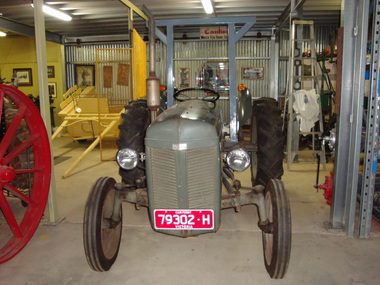
Fergie Tractor
Grey Ferguson tractor restored to working order with a detachable grader blade. A rollover protection bar has been added to comply with modern regulations for safety. Three point linkage and 3 new tyres. Club permit registration. Metal plates on front and sides "Ferguson". Serial No. plate on steering column mount etched No. "533? "........." Henry Ferguson / ........ / TE14 "351?".rural industry - farm machinery; -
 The 5th/6th Battalion Royal Victoria Regiment Historical Collection
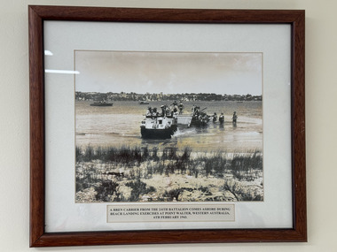
Photograph - Photograph of soldiers of 2/6th Battalion on exercise in 1943
A photograph 2/6th Battalion soldiers on exercise. The explanation text stating "A Bren carrier from the 2/6th Battalion comes ashore during beach landing exercises at point Walter, Western Australia, 6th February 1943." -
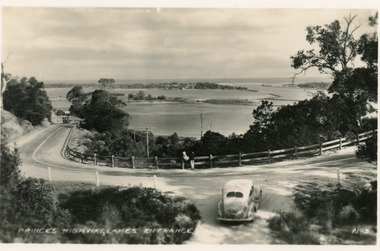 Lakes Entrance Historical Society
Postcard - Princes Highway Kalimna, Valentine Series, 1930c
Black and white postcard of a bend in the Princes Highway as it winds around Jemmys Point, car parked beside highway, two people leaning on post and rail fence, Bullock Island and Lakes Entrance in the distance. Lakes Entrance VictoriaPrinces Highway Lakes Entrancefences, transport, roads and streets -
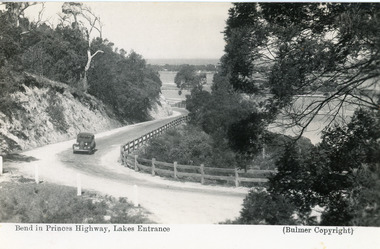 Lakes Entrance Historical Society
Postcard - Princes Highway Kalimna, Bulmer H D, 1935c
Black and white postcard of the Princes Highway as it winds around Jemmys Point. A motor car driving up the hill between steep road cutting and post and rail fence. View of the lake and ocean in the distance. Lakes Entrance VictoriaBend in Princes Highway, Lakes Entrance fences, roads and streets -
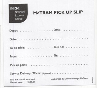 Melbourne Tram Museum
Document - Instruction, M>Tram, "M>Tram Pick up slip", Jun. 2001
Instruction - titled "M>Tram Pick up slip", taken from a pad of sheets, advising drivers which table / Run no to operate on a date and from which point. dated 25/6/2001. 3 copies held.trams, tramways, m>tram, national express, drivers, table cards, operations -
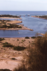 Lakes Entrance Historical Society
Photograph - The Entrance, 1995c
Colour photograph of the entrance from Bass Strait to the Gippsland. It shows the western and of Bullock Island and the built up area below Jemmys Point, all made during dredging operations over many years. Lakes Entrance Victoriafishing industry, islands, waterways