Showing 31827 items
matching south
-
 Eltham District Historical Society Inc
Photograph, Jim Connor, Avenue of Honour, Main Road, Eltham, 14 Jan 2017
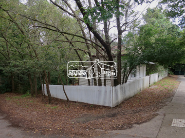
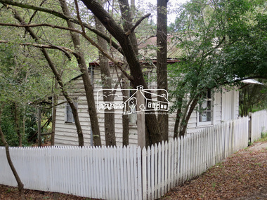
Eltham Gateway, The old Bootmaker's Cottage adjacent to Whitecloud Cottage, 701 Main Road, Eltham The bootmaker's shop was operated by John Henry (Harry) Clark from about 1930. Clark was originally a photographer along with his brothers William (Will) Charles Clark and Clement Kent Clark. They operated as Clark Bros Photographers based at 25 Thomas Street, Windsor (Prahran) from about 1895 to 1915 at which point the premises was demolished.. Brother Clement died in 1912. By 1916 Harry was living and working as a photographer in Eltham and was recorded on the electoral rolls as a photographer up to and incliiding at least 1928. By 1931 he had changed proession to Bootmake and again continued on Main Road, Eltham South as a Bootmake at least until 1954. He died at St Vincent'e Hospital in Dec 1956. It is believed non of the brothers married. Whilst very little public record exists og Harry in the papers either as a photographer or bootmaker, one incident was reported in 1935 when he witnessed a girl on a bike come crashing down Main Road and into the pond next to his shop.Tomorrow's history documented todayeltham, jim connor collection, main road, eltham gateway, avenue of honour, dalton street, wingrove park trail, bootmakers cottage -
 Eltham District Historical Society Inc
Photograph, Jim Connor, Avenue of Honour, Main Road, Eltham, 14 Jan 2017
Eltham Gateway, The old Bootmaker's Cottage adjacent to Whitecloud Cottage, 701 Main Road, Eltham The bootmaker's shop was operated by John Henry (Harry) Clark from about 1930. Clark was originally a photographer along with his brothers William (Will) Charles Clark and Clement Kent Clark. They operated as Clark Bros Photographers based at 25 Thomas Street, Windsor (Prahran) from about 1895 to 1915 at which point the premises was demolished.. Brother Clement died in 1912. By 1916 Harry was living and working as a photographer in Eltham and was recorded on the electoral rolls as a photographer up to and incliiding at least 1928. By 1931 he had changed proession to Bootmake and again continued on Main Road, Eltham South as a Bootmake at least until 1954. He died at St Vincent'e Hospital in Dec 1956. It is believed non of the brothers married. Whilst very little public record exists og Harry in the papers either as a photographer or bootmaker, one incident was reported in 1935 when he witnessed a girl on a bike come crashing down Main Road and into the pond next to his shop.Tomorrow's history documented todayeltham, jim connor collection, main road, eltham gateway, avenue of honour, dalton street, wingrove park trail, bootmakers cottage -
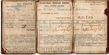 Lara RSL Sub Branch
Drivers Licence, Australian Military Forces Army Driving Licence
Cpl. Ronald Warren Ellis, EM (VX502517) was born in Brunswick in 1927. His family moved to Lara when he was young, and his schooling took place at the Lara State School. After finishing his education, Ron took up employment at Sims Coopers in Corio. Ron was enlisted in the second AIF at Melbourne, and posted to the 3rd Recruit Training Battalion at Greta west of Newcastle, NSW. After 3 months training, he was sent to the Service Corps Training Centre for driver and maintenance training in Ingleburn, south of Sydney. When this course was completed, Ron was posted to the Australian Army Service Corps as a driver motor vehicle with the 2nd AIF. Rons service with the AIF lasted 425 days, when he was then transferred to the Interim Army for a further 309 days. The duration of his service was in NSW. Ron was discharged from the Army in Melbourne on the 4th of May 1948. In 1957, Ron enlisted in the CMF and served with 22nd Construction Squadron for 17 years with the last 5 as a Corporal, and was awarded the Efficiency Medal for long service and good conduct.Brown canvas booklet that is folded into three. Licence gives details of Army number, name, rank and type of vehicle that is able to be driven. Licence has been issued to Private Ronald Warren Ellis on 24/01/1948. No. 258778 Army No. V?SOL517 Rank: Private Name in full: Ellis, Ronald Warren Unit: Transferred to (unit): Having passed the prescribed tests ... authorised to drive... types of ... vehicles within the Commonwealth of Australia and Territories. Signature of Driver: drivers licence, australian military forces, army, private, ellis, ww2, wwii, world war two, second world war -
 Eltham District Historical Society Inc
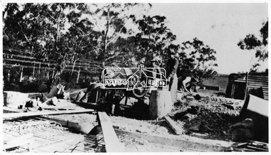
Negative - Photograph, Construction of the new concrete bridge over the Diamond Creek on Main Road, Eltham, c.May 1926
Construction of the new concrete bridge over the Diamond Creek on Main Road, Eltham, c.May 1926. Viewed from northern approach looking south east towards Eltham Park (Eltham Lower Park), showing the power lines that used to run in front of the park. The original long suspension bridge over the Diamond Creek on Main Road at Eltham collapsed during flooding of the Diamond Creek on October 13 and 14, 1923. The original bridge was built around 1840 for the coach road when Cobb & Co.'s coach was the only conveyance between Eltham and Melbourne. Widespread damage was done in Melbourne and surrounding areas by floods resulting from the overflow of the Yarra at many points along its banks. A temporary bridge rigged up was severely damaged by the flooding of the creek and was closed to vehicular traffic in April 1924. A new concrete bridge was constructed to replace it and by May 1926 all the concrete piles and abutments had been completed. The bridge was finally completed and opened for traffic in September 1926, almost three years after it initially collapsed.This photo forms part of a collection of photographs gathered by the Shire of Eltham for their centenary project book,"Pioneers and Painters: 100 years of the Shire of Eltham" by Alan Marshall (1971). The collection of over 500 images is held in partnership between Eltham District Historical Society and Yarra Plenty Regional Library (Eltham Library) and is now formally known as the 'The Shire of Eltham Pioneers Photograph Collection.' It is significant in being the first community sourced collection representing the places and people of the Shire's first one hundred years.Digital image 4 x 5 inch B&W Negshire of eltham pioneers photograph collection, bridge, bridge construction, cement mixer, diamond creek (creek), eltham, eltham lower park, eltham south, main road bridge -
 Eltham District Historical Society Inc
Photograph, Liz Pidgeon, Heritage Excursion; East of Eltham, 6 Sep 2014, 20 May 2017
Newsletter No. 218, September 2014 September Excursion - East of Eltham Walk In Newsletter No. 197, March 2011, there was a brief history of Crown Allotment 15 Section 5 Parish of Nillumbik (CA 15) a parcel of land of a quarter of a square mile extending from Eucalyptus Road to Reynolds Road at the eastern extremity of Eltham. From the 1940s it was known as Stokes orchard. In later years it has been subdivided for residential purposes but leaving significant areas as power line and water supply reserves and bushland reserves that are habitat for the threatened For our excursion on 6th September we intend to walk through CA 15 to a bushland reserve east of Reynolds Road. The walk will traverse the boundary between suburban Eltham and the non-urban areas to the south and east. This is a pleasant walk through residential areas and bushland. Along the way we will discuss the early and more recent history of CA 15 as well as local natural history and geology. This walk is about 3.5 km in length and will take 2 to 2.5 hours. It will start at 2pm at the corner of Eucalyptus Road, Pitt Street and Nyora Road.Born Digitaleltham east, eltham district historical society, heritage excursion, activities, nyora road, reynolds road, gum tree road reserve, diosma road, stokes orchard, eucalyptus road -
 Eltham District Historical Society Inc
Photograph, Liz Pidgeon, Heritage Excursion; East of Eltham, 6 Sep 2014, 20 May 2017
Newsletter No. 218, September 2014 September Excursion - East of Eltham Walk In Newsletter No. 197, March 2011, there was a brief history of Crown Allotment 15 Section 5 Parish of Nillumbik (CA 15) a parcel of land of a quarter of a square mile extending from Eucalyptus Road to Reynolds Road at the eastern extremity of Eltham. From the 1940s it was known as Stokes orchard. In later years it has been subdivided for residential purposes but leaving significant areas as power line and water supply reserves and bushland reserves that are habitat for the threatened For our excursion on 6th September we intend to walk through CA 15 to a bushland reserve east of Reynolds Road. The walk will traverse the boundary between suburban Eltham and the non-urban areas to the south and east. This is a pleasant walk through residential areas and bushland. Along the way we will discuss the early and more recent history of CA 15 as well as local natural history and geology. This walk is about 3.5 km in length and will take 2 to 2.5 hours. It will start at 2pm at the corner of Eucalyptus Road, Pitt Street and Nyora Road.Born Digitaleltham east, eltham district historical society, heritage excursion, activities, nyora road, reynolds road, gum tree road reserve, diosma road, stokes orchard, eucalyptus road