Showing 110322 items matching "roads"
-
 Greensborough Historical Society
Slide - Photograph, John Ramsdale, Rural panorama: Slide 14
Photograph shows view across a road and open land to large house in a rural setting. At the time of the photograph was named 'Odyssey House' at Lower Plenty, Pre 1976 it was known as the Blessed Sacrament Fathers Seminary.Part of the John Ramsdale collection of slides and audio visual material.Colour photograph scanned from slide.No maker's marks. No caption on slide.rural landscape -
 Greensborough Historical Society
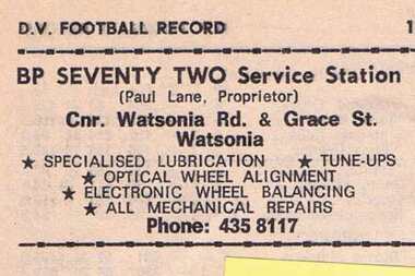
Advertisement - Digital Image, BP Seventy Two Service Station 1973, 09/06/1973
Advertisement for BP Seventy Two Service Station corner Watsonia Road and Grace Street Watsonia. Proprietor Paul Lane. Copied from a Diamond Valley Football League football record from 1973.Digital copy of advertisement from booklet.diamond valley football league, bp seventy two service station, paul lane, watsonia road watsonia, grace street watsonia -
 Greensborough Historical Society
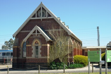
Photograph - Digital Image, Marilyn Smith, Mernda Uniting Church 2018, 27/09/2018
In 2018 GHS members visited Turner's Bakery in Mernda for lunch and continued on to visit historic sites remaining in the Mernda area. This photograph shows the Mernda Uniting Church, established in 1888. It is sited on Schotters Road. Mernda is an area of rapid modern growth with a few remaining historic buildings dating from the 19th century.Digital copy of colour photographmernda, mernda historic sites, schotters road mernda, mernda uniting church -
 Greensborough Historical Society
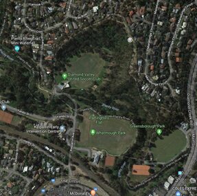
Aerial Photograph - Digital Image, Greensborough central with modern landmarks, 2015_
Aerial photograph of Greensborough showing modern landmarks and businesses, including Partington's Flat, Whatmough Park, Plenty River Trail. Bounded by Diamond Creek Road to the East and the Plenty River to the East, The Circuit to the South. Aerial photograph in colour with overlay text indicating modern landmarksgreensborough, manatunga circuit greensborough, plenty river, diamond creek road greensborough, the circuit greensborough, aerial photograph -
 Phillip Island and District Historical Society Inc.
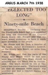
Newspaper clippings, 07/03/1938
Article in which Chairman of Country Roads Board (Mr Fricke) declared that the Ninety Mile Beach had been neglected and should be a Tourist asset. The Board would arrange water supply and Comfort Station.Article about Ninety Mile Beach.local history, documents, newspapers, ninety mile beach, black & white newspaper clipping -
 Greensborough Historical Society
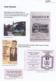
Document collection, Marilyn Smith, Keith Wilkie, 2019_
Keith Wilkie owned Keith Wilkie's Men's and Boy's Wear, 33 Were Street Montmorency (name varies), and Keith and Rose-Marie's place of residence was at 57 Greenhills Road Greensborough 1967-72.1 p. scanned photographs and information collected by Marilyn Smith.keith wilkie's men's and boy's wear, were street montmorency, wilkie family -
 Greensborough Historical Society
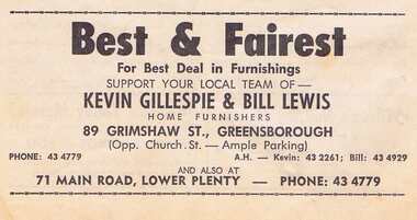
Advertisement - Digital Image, Gillespie and Lewis 1968, 25/08/1968
Advertisement for Gillespie and Lewis of Grimshaw Street Greensborough and Main Road Lower Plenty. Proprietor: Kevin Gillespie and Bill Lewis. Copied from a Diamond Valley Football League football record from 1968.Digital copy of advertisement from booklet.diamond valley football league, gillespie and lewis, kevin gillespie, bill lewis, grimshaw street greensborough, main road lower plenty -
 Greensborough Historical Society
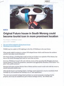
Article - Website, Paul Shapiro, Original Futuro house in South Morang, by Paul Shapiro, 02/07/2017
Of Finnish design, the building has been used as a sales booth at the Apollo Parkways estate, and moved to the TUKE Go-Kart Track on McDonalds Road South Morang, where it is being used as a storage building.3 p. text and col. and black and white photographs (digital reprint of original publication)futuro house, apollo parkways -
 Greensborough Historical Society
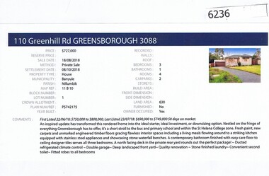
Advertising Leaflet, Barry Plant Greensborough, 110 Greenhill Road Greensborough, 18/08/2018
Real estate advertising for 110 Greenhill Road Greensborough, 3 bedroom house; sold August 2018 for $727,000. Previous sales: September 2009 for $500,000; November 2007 $410,000 and June 1994 $130,000. Real estate advertisement black text and colour photographgreenhill road greensborough -
 Greensborough Historical Society
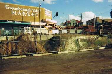
Photograph - Digital image, Para Road Greensborough from the Station, 1975_
Photograph of the intersection of Para Road and Main Street Greensborough circa 1975. Shows the Greensborough Valley Market on the corner and Greensborough Hotel in background. Taken from the Station, the train line can be seen in the foreground.Digital copy of colour photograph.greensborough valley market, greensborough station, para road, main street greensborough -
 Greensborough Historical Society
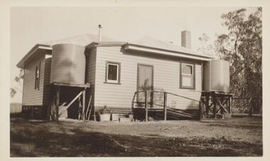
Photograph - Digital image, Rose McLaughlin's Beales Road house from rear, 1936, 1936_
Part of a collection of photographs copied from the late Shirley Fraser (nee Black), also descendant of the McLaughlin and Whatmough family. This photograph shows Rose McLaughlin's Beales Road house from the rear 1936.Digital copy of black and white photograph.shirley fraser, rosalie mclaughlin -
 Greensborough Historical Society
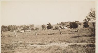
Photograph - Digital image, View from Rose McLaughlin's house, Beales Road Greensborough 1937, 1937_
Part of a collection of photographs copied from the late Shirley Fraser (nee Black), also descendant of the McLaughlin and Whatmough family. This photograph shows the view from Rose McLaughlin's Beales Road home in 1937.This photograph shows the rural nature of Greensborough in the 1930s.Digital copy of black and white photograph.shirley fraser, rosalie mclaughlin, beales road -
 Greensborough Historical Society
Photograph - Digital image, John Blackbourn, 1940_
John Blackbourn, born Greensborough Hospital 1936; taken at 122 Main Road Lower Plenty. Photographs from the collection of Peter Blackbourn, a descendant of the Chapman Stock family. Annotations to photos by Peter Blackbourn.Digital copy of black and white photograph.peter blackbourn, john blackbourn -
 Greensborough Historical Society
Photograph - Digital image, Kathleen Barnett, 1939c
Kathleen Barnett was born in 1917; this photograph was taken in the backyard of 122 Main Road Lower Plenty. Photographs from the collection of Peter Blackbourn, a descendant of the Chapman Stock family. Annotations to photos by Peter Blackbourn.Digital copy of black and white photograph.peter blackbourn, kathleen barnett -
 Greensborough Historical Society
Photograph - Digital image, Reg and Jean Huggett, 1930c
Reg and Jean Huggett (1913-2004), photograph taken at 122 Main Road Lower Plenty. Photographs from the collection of Peter Blackbourn, a descendant of the Chapman Stock family. Annotations to photos by Peter Blackbourn.Digital copy of black and white photograph.peter blackbourn, jean huggett, reg huggett, 122 main road lower plenty -
 Greensborough Historical Society
Photograph - Digital Image, Turner Street from Flodden Way Briar Hill, 1966-1969
View from Flodden Way, looking down Turner Street. "The road went round the tree". The Noone family lived at 1 Flodden Way from 1966 to 1969. Caption by Julie Noone 2017.Shows the development of the area in the 1960s.Digital copy of colour photograph, taken from photographic slide.flodden way briar hill -
 Halls Gap & Grampians Historical Society
Photograph - B/W, C 1930
Jack Watson left & Ernie Ward, residents of Halls Gap on holiday at Mt Buffalo in the 1930's. Jack Watson was a road worker he proposed the idea of the native wildflower show in Halls Gap.people, road gang -
 Greensborough Historical Society
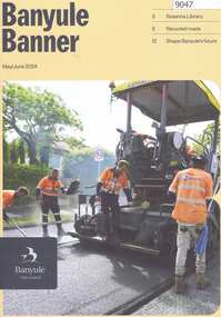
Magazine, Banyule Banner May/June 2024, 2024_06
The Banyule Banner is published by Banyule Council to advertise upcoming events in the City of Banyule and to report on past events. This edition contains reports on Rosanna Library, recycled roads and Watsonia town square and station redevelopment.A record of events within the City of Banyule.24 pages, colour illustrations. banyule banner, banyule council -
 Eltham District Historical Society Inc
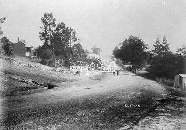
Negative - Photograph, Eltham, Main Road, c.1910
Eltham, Main Road. Looking south from Henry Street towards Bakery (on left), c.1910 Mrs Davis house on left - Doug Orford recalled that there was always a dog on the couch on the front verandahThis photo forms part of a collection of photographs gathered by the Shire of Eltham for their centenary project book,"Pioneers and Painters: 100 years of the Shire of Eltham" by Alan Marshall (1971). The collection of over 500 images is held in partnership between Eltham District Historical Society and Yarra Plenty Regional Library (Eltham Library) and is now formally known as the 'The Shire of Eltham Pioneers Photograph Collection.' It is significant in being the first community sourced collection representing the places and people of the Shire's first one hundred years.Digital image 4 x 5 inch B&W Neg Print 20 x 25 cmsepp, shire of eltham pioneers photograph collection, eltham, main road, bakery, henry street, mrs davis house -
 Eltham District Historical Society Inc
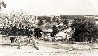
Photograph postcard, View at Diamond Creek, Vic., C. 1925-c.1930
Looking southwest from near the intersection of Clyde Street with Cowin Street (in vicinity of State School). St Anne's Church of England (with steeple) is on left side of Main Road. The Rose Series P. 4283Digital file only Postcards scanned from the collection of Michael Aitken on loan to EDHS, 13 Feb 2018michael aitken collection, postcards, diamond creek -
 Orbost & District Historical Society
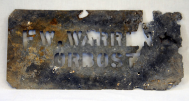
stencil, first half 20th century
This was used by Frank Warren at Bete Bolong / Newmerella. The Warren Brothers had a farm on the Bete Bolong road at Newmerella. They grew beans, peas, maize and pumpkins for export to Melbourne (by train) until the 1970's.This item is significant because it was specially made agricultural produce in the Orbost district, a major industry in the first half of the 20th century.A metal stencil for use on bean or maize bags. It is rectangular with rounded corners, Cut out is "F.W. WARREN ORBOST"agriculture farming warren stencil -
 Port Melbourne Historical & Preservation Society
Functional object - Missions to Seamen building, Port Melbourne, BI Ltd, 1937
Liana THOMPSON, Mayor of Port Phillip at the time, purchased many of the bricks from the demolished Mission and used them to pave their yard at 488 Williamstown Road. She and David saved two for PMH&PSTwo bricks from the 1937 Missions to Seamen building demolished 1995. Salmon coloured, with bits of mortar; impressed one side with 'BI Ltd'mission to seamen, demolitions, liana thompson, harry a norris -
Tatura Irrigation & Wartime Camps Museum
Photograph - copy, D. Clark, F. E. Williams Store c 1920, 1920 original 1989 copy
Copy of original photograph of grocery window display, arranged and photographed by Frank Stevenson. Later to have his own grocery store. reflection of fire brigade station across the road. Original photograph L0330Copy of original sepia photograph of store grocery window display, F. E. Williams store. c 1920. Exterior.on back: F. E. Williams Shop. Grocery window display. c 1920. Arranged and photographed by Frank Stevenson 1920's. Reflection of fire brigade station.f. e. williams store -
 Lake Bolac & District Historical Society
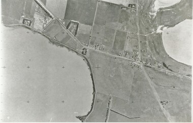
Black and white photograph, Aerial View of Lake Bolac, 1947
Aerial view of Lake Bolac (Boloke) taken in 1947. Fresh water lake at bottom left, salt lakes at top right, village at crossroads of north-south Glenelg highway and Ararat-Mortlake road.lake bolac, 1947, glenelg highway -
Whitehorse Historical Society Inc.
Pamphlet, Hill 60 Estate, 1/02/1929 12:00:00 AM
Auctioneers brochure for Hill 60 estate,Auctioneers brochure for Hill 60 estate, Tunstall, 37 sites, subdivisional auction sale, 3.30 pm Saturday 23 February 1929. Agent: Frank Fisher & CoAuctioneers brochure for Hill 60 estate, hill 60 estate, tunstall, frank fisher & co, forest hill, menin road, nunawading, mount pleasant road, nunawading, shady grove, nunawading, fisher, frank -
 Whitehorse Historical Society Inc.
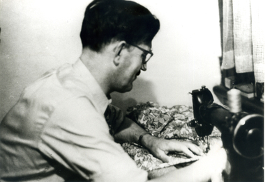
Photograph, Bert Linghard at his sewing Machine, 1/02/1949
Bert Lingard was a Tailor whose business 'Lingard Modes' operated in the Manchester Unity Building, Swanston Street, Melbourne c1949. Later he worked from his home in 476 St.Kilda Road, Melbourne.Black and white photograph of Herbert (Bert) Lingard at his sewing machine. Cross ref. NA2931 -2933 and NA2946 & 7.lingard collection -
 Whitehorse Historical Society Inc.
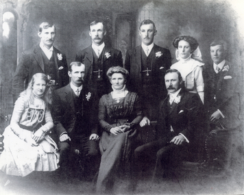
Photograph, Edwards family, Forest Hill
Martha (nee Course) and Arthur Edwards married at Forest Hill in 1899. They lived in Husband Road, Forest Hill, first with Martha's father, then in a house built by Arthur in 1910. The house still stands (in 2006)Black and white photograph of the Edwards family of Forest Hill, taken in 1930. Standing: Ronald Edwards, Theodore Edwards, Vera Edwards, Stanley Edwards, Alfred Edwards Seated: Martha Edwards, Violet Edwards, Arthur Edwards paperSee also ND5558edwards family, forest hill -
Bialik College
Photograph (Item) - Daphne Gaddie at the first exhibition in the ELC at the Auburn Road campus
ELC staff member Daphne Gaddie at the first exhibition in the ELC at the Auburn Road campus, following the move from Shakespeare Grove, c. 1995. Please contact [email protected] to request access to this record.1990s -
Bialik College
Plan (item) - Bialik College development, 1979-1980
Architectural plans of proposed Bialik College, 429 Auburn Road, Hawthorn East, created by architects Joshua and Mary Pila, May 1979-1980. Please contact [email protected] to request access to this record.1970s, 1980s, building and planning -
Bialik College
Scrapbooks, Student work
Scrapbooks of student work, including 'The Beginning', 'Land Reclamation', 'Planting Trees', 'Good Farming', 'Planning and Roads', c. 1980s and a booklet of poetry, 1984. Please contact [email protected] to request access to this record.student work, poetry, 1980s