Showing 110304 items matching "roads"
-
 Glen Eira Historical Society
Article - Koornang Road, 77-79, Carnegie
A colour newspaper article, identified as from the Property Review Weekly of 26/09/2003, advertising the auction of 77-79 Koornang Road on 10/10/2003. The article includes a colour photograph of the building exterior.carnegie, koornang road, shops, anz bank carnegie, banks, auctions -
Glen Eira Historical Society
Article - Koornang Road, 81-81A, Carnegie
A colour newspaper article, source unknown, dated 03/08/2001, advertising the auction of two shops at 81 and 81A Koornang Road on 17/08/2001. The article includes a colour photograph of the building exterior.carnegie, koornang road, shops, auctions -
Glen Eira Historical Society
Document - Palmyra, 88 Orrong Road, Elsternwick
An advertisement dated 22/03/2006 including coloured photograph of Palmyra, 88 Orrong Road, ELsternwick. The home has been divided into boutique assited living apartments for over 55 year age bracket.orrong road, elsternwick, stavrakis bill, palmyra, glenhuntly road -
Glen Eira Historical Society
Document - Caulfield Police Station
A one page program of events for the Official Opening Ceremony of the Caulfield Police Station at 289 Hawthorn Road, Caulfield, held on 13/02/2001. The program provides a list of participating officials and their functions during the ceremony.shardey helen, gassner leigh, thomas alf , barker ann, caulfield grammar school, caulfield, hawthorn road, caulfield police station, police station, mcutchen robert reverend, pilmer jim reverend, opening ceremony, official ceremony, flag, plaque, police -
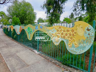
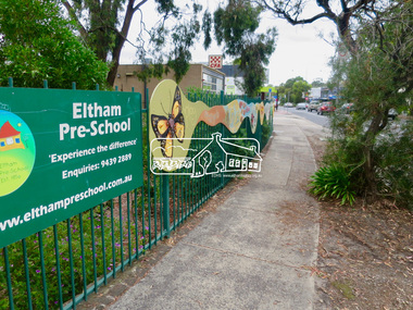 Eltham District Historical Society Inc
Photograph, Jim Connor, Main Road, Eltham, 14 Jan 2017
Eltham Gateway, Mural, Eltham Pre-school, 907 Main Road, Eltham "We are glad the people of Eltham built this special place for children in 1956." The pre-school celebrates its 65th anniversary in 2021.Tomorrow's history documented todayeltham, jim connor collection, main road, eltham gateway, eltham pre-school, eltham war memorial, war memorial buidings -
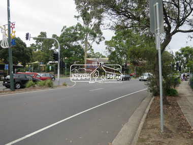 Eltham District Historical Society Inc
Photograph, Jim Connor, Main Road, Eltham, 14 Jan 2017
Eltham Gateway, Our Lady of Help of Christians Primary School, 1-13 Henry St, Eltham viewed looking south from near the CFA building across Main Road to Dudley Street intersectionTomorrow's history documented todayeltham, jim connor collection, main road, eltham gateway, dudley street, our lady help of christians primary school -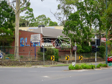
 Eltham District Historical Society Inc
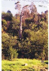
Photograph, Peter Pidgeon, Manna Gum, Main Road, Eltham South, 8 Sep. 2021
This significant tree located near the Main Road Bridge over the Diamond Creek at Eltham dates back to approximately 1870-1880. Though dead now, its trunk has been left as a wildlife habitat.These trees are not only significant for the natural environment but also present a navigational beacon back in time as the environmental landscape is developed around them.Born Digitaleltham south, main road bridge, manna gum, significant tree -
 Eltham District Historical Society Inc
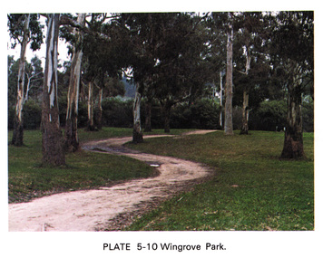
Work on paper (Sub-Item) - Photograph, Wingrove Park
Colour photograph of winding walking trail through trees at Wingrove Park. Wingrove Park in named for Eltham pioneer Charles S. Wingrove, Secretary and Engineer to the Eltham Road Board and Shire Council, 1858-1904eltham, gum trees, eucalpypts, walking trail, wingrove park -
 Marysville & District Historical Society
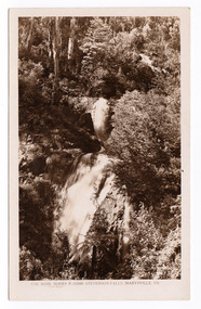
Postcard (item) - Black and white postcard, Rose Stereograph Company, Stevenson Falls, Marysville, Vic, 1913-1967
A postcard in a series produced by the Rose Stereograph Company in Victoria, Australia as a souvenir of Marysville. The Steavenson Falls is named after the Victorian Assistant Commissioner of Roads and Bridges, John Steavenson, who arrived in Victoria in the early 1860s.A black and white photograph of Steavenson Falls, Marysville, Victoria. The Steavenson Falls is named after the Victorian Assistant Commissioner of Roads and Bridges, John Steavenson, who arrived in Victoria in the early 1860s. At 84 metres high, Steavenson Falls is Victoria's tallest cascading waterfall. The falls are split into roughly five cascades, with the last of these plunging into a small, picturesque rock pool. This postcard was produced by the Rose Stereograph Company as a souvenir of Marysville.THE ROSE SERIES P. 10200/ COPYRIGHT/ STEVENSON FALLS, MARYSVILLE, VIC. POST CARD The "Rose" Series/ De Luxe A Real Photograph/ Produced in Australia Published by the Rose Stereograph Co.,/ Sydney and Melbournestevenson falls, marysville, victoria, waterfalls, p. 10200, steavenson falls, rose series postcard, postcard, souvenir, john steavenson -
![Newspaper Clipping - Digital Image, 2000 [pounds] for public open space 1965, 05/11/1965](/media/collectors/4f729f5697f83e03086015b8/items/5eb3933621ea670b94e21892/item-media/5eb3938a21ea670b94e2e147/item-fit-380x285.jpg) Greensborough Historical Society
Greensborough Historical SocietyNewspaper Clipping - Digital Image, 2000 [pounds] for public open space 1965, 05/11/1965
In 1965, the Board of Works advised Eltham Council that it had purchased 1 1/2 acres of land adjoining the Plenty River off Para Road zoned for public open space and offered the land to Council.An example of developments in the Greensborough area during the 1960sNews clipping, black and white text.shire of diamond valley, para road greensborough, melbourne and metropolitan board of works, plenty river, shire of eltham -
 Greensborough Historical Society
Photograph - Photograph (Copy), Anne Paul, Squizzy Taylor's target tree, taken from old road in front of Plenty Bridge Hotel, Lower Plenty 2003, 2003_05
Squizzy Taylor's target tree, taken from old road in front of Plenty Bridge Hotel, Lower Plenty 2003. It is believed that Squizzy Taylor hid at the Plenty Bridge Hotel and used this tree for target practice.2 colour photographs printed on paper, handwritten captionslower plenty, plenty river, squizzy taylor, plenty bridge hotel -
Phillip Island and District Historical Society Inc.
Photograph
Phillip Island Suspension Bridge - 1st Road connection between Phillip Island and mainland, Newhaven to San Remo. Built 1938/40, demolished 1970. Part of an album compiled and donated by Mrs Helen Jansson.Print of the Phillip Island Suspension Bridge.Hand lettered descriptive caption adjoining this photo print.local history, photography, photographs, slides, film, civil engineering, bridges, phillip island bridge, black & white photograph, mrs. helen jansson, suspension bridges, phillip island -
Phillip Island and District Historical Society Inc.
Photograph, 1968
Phillip Island Suspension Bridge built 1938/40. First road connection to mainland at San Remo - demolished 1970. Second bridge under construction. Part of an album compiled and donated by Mrs Helen Jansson.Print of Phillip Island second Bridge under construction. Showing Pylon supports in framing.Hand lettered under photograph. San Remo approach.local history, photography, photographs, slides, film, civil engineering, bridges, phillip island bridges, black & white photograph, mrs helen jansson, phillip island bridge -
 Greensborough Historical Society
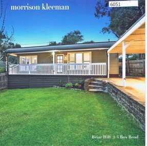
Advertising Leaflet, 1/4 Box Road Briar Hill, 23/10/2018
1/4 Box Road Briar Hill. 3 bedroom house. Sold October 2018 for $744,000. Previous sales: May 2017 for $590,000, March 2007 for $315,000, and February 2005 for $291,000. Built 1980.Real Estate advertising leaflet,1 sheet folded into 4 pages, printed in colour both sides. 2 copies.box road briar hill -
 Greensborough Historical Society
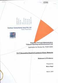
Document, Statement of evidence: VCAT Application P2461/2003, prep. by Marco Negri, Contour Consultants Aust Pty Ltd, 2004_03
Lawyers for the City of Banyule commissioned a report on the town planning implications of a proposal to construct a multi-level building on land at the corner of Lambourn and Devonshire Roads Watsonia, relating to the Council's refusal of a permit and the subsequent hearing by VCAT22 p., black & white with col. plans.watsonia, lambourn road watsonia, devonshire road watsonia -
 Greensborough Historical Society
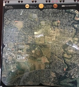
Aerial Photograph, AAM Photographics, Heidelberg AAM1969c 086, 24/11/1991
One of a series of four overlapping aerial photographs of the Heidelberg/Greensborough areas in 1991, covering Simpson Barracks, Macleod, Rosanna, Viewbank, Watsonia & Yallambie. North boundary Yallambie Road; West boundary Hurstbridge railway.Laminated colour aerial photographssimpson barracks, yallambie, watsonia, macleod, rosanna, viewbank -
 Greensborough Historical Society
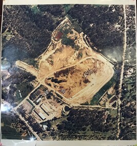
Aerial Photograph, AAM Photographics, Heidelberg AAM1969c 088, 24/11/1991
One of a series of overlapping aerial photographs of the Heidelberg/Greensborough area, covering Eaglemont, Heidelberg, Ivanhoe East & Viewbank. North boundary Hurstbridge railway, South boundary Ivanhoe East, East boundary Bulleen RoadLaminated colour aerial photographeaglemont, heidelberg, ivanhoe east, viewbank -
![Photograph - Digital image, 122 Main Road Lower Plenty [Caroline Barnett and son Alfred], 1945c](/media/collectors/4f729f5697f83e03086015b8/items/54bec7c92162f1159cba0945/item-media/54bec7f82162f1159cba0dcb/item-fit-380x285.jpg) Greensborough Historical Society
Greensborough Historical SocietyPhotograph - Digital image, 122 Main Road Lower Plenty [Caroline Barnett and son Alfred], 1945c
122 Main Road Lower Plenty; looking toward the Primary School with Caroline Barnett and son Alfred. Photographs from the collection of Peter Blackbourn, a descendant of the Chapman Stock family. Annotations to photos by Peter Blackbourn.Digital copy of black and white photograph.peter blackbourn, 122 main road lower plenty, caroline barnett -
 Greensborough Historical Society
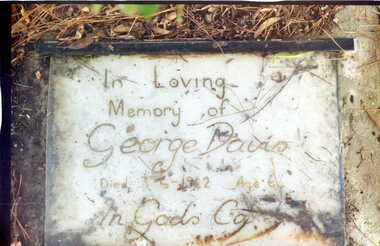
Photograph - Digital Image, Grave of George S Davis, Greensborough Cemetery, 03/06/1942
Grave of George S Davis (died 3/6/1942) in Plot# Q19 Greensborough Cemetery. Photograph taken by Noel Withers 30/07/2009. The Davis family lived in Britnell's Road, Briar Hill.Greensborough Cemetery was created when land was given for the cemetery by Mr William Poulter, a local settler, about 1864. The cemetery holds the graves of many of the early settlers in the district. The cemetery holds approximately 250 grave sites with 350 people buried there.Digital copy of colour photograph of grave/headstone.george s davis, greensborough cemetery -
 Greensborough Historical Society
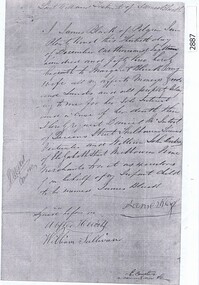
Document, Last Will and Testament of James Black, 1853_
Last will and testament of James Black of Pilgrim Inn, Plenty Road, with probate documents, 1854. Preceded the unrelated Black family who leased and owned land in the Watsonia area in the late 19th and early 20th centuries.5 p. photocopies of Will and Bondjames black [plenty road] -
 Greensborough Historical Society
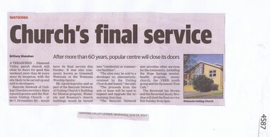
Newspaper Clipping, Diamond Valley Leader, Church’s final service, 14/06/2017
A treasured Diamond Valley parish church in Devonshire Road Watsonia will close its doors for good this weekend more than 60 years since its inception, with the site likely to be carved up and sold to developers.News article 1 page, black text, colour image.watsonia uniting church, devonshire road, gresswell watsonia -
 Greensborough Historical Society
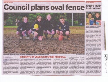
Newspaper Clipping, Diamond Valley Leader, Council plans oval fence; and, Enjoy a laugh to aid school, 20/07/2016
Article 1: Vandalism at Simms Road Oval has led to plans to fence the oval by Banyule Council. Article 2: A fundraiser at St Francis Xavier Primary School was used to purchase sports and library equipment. News clipping, black text and colour imagemontmorency, simms road oval montmorecy, st francis xavier primary school -
 Greensborough Historical Society
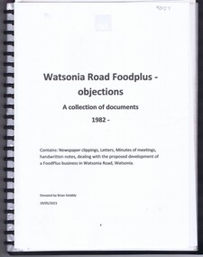
Document - Document Collection, Watsonia Road Food Plus - objections: a collection of documents 1982, 1982
Documents collected by Brian Smiddy from 1982. Includes newspaper clippings, handwritten notes, minutes of meetings and letters dealing with the proposed development of a Food plus business in Watsonia Road Watsonia. Contains objections to this development.Plastic folder with clear cover and black plastic binding containing approx 8 documents and handwritten notes.brian smiddy, watsonia food plus, watsonia s, watsonia shopping centre, watsonia road watsonia -
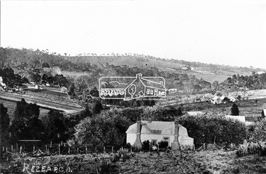 Eltham District Historical Society Inc
Photograph, Research, Vic
Research. House in centre foreground is same house as centre left Ref. 512. Looking about south-south west, down Research Gully Road. Source: Mrs. E.R. Reynolds, Thompson Crescent, ResearchThis photo forms part of a collection of photographs gathered by the Shire of Eltham for their centenary project book,"Pioneers and Painters: 100 years of the Shire of Eltham" by Alan Marshall (1971). The collection of over 500 images is held in partnership between Eltham District Historical Society and Yarra Plenty Regional Library (Eltham Library) and is now formally known as the 'The Shire of Eltham Pioneers Photograph Collection.' It is significant in being the first community sourced collection representing the places and people of the Shire's first one hundred years.Digital imagesepp, shire of eltham pioneers photograph collection, research (vic.) -
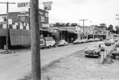 Eltham District Historical Society Inc
Photograph, Shopping centre, Main Road, Eltham, February 1968, Feb 1968
East side Main Road shops from Luck Street to Dudley Street. Includes Browne's Self Service, Milk Bar, Delicatessen, Chemist, Mac's Meats, Thompson's Pharmacy, N.H. Baxter Estate Agent.In February 1968 an unknown person took a series of photos from the Eltham Hotel at Pitt Street heading north along Main Road through the shopping centre to just north of Elsa Court covering the length of the section of Main Road which was duplicated shortly thereafter. Shows the condition and environment of the streesscape of Main Road, Eltham immediately prior to the duplication between Pitt Street and Elsa Court through the shopping centre. Also shows a number of shops and businesses that operated at that time.Black and white photographduplication, eltham, main road, browne's self service, dudley street, milk bar, delicatessen, chemist, mac's meats, thompson's pharmacy, n.h. baxter estate agent