Showing 25285 items
matching north or new hustlers
-
 Eltham District Historical Society Inc
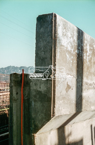
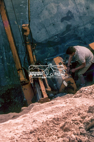
Slide, Sherbourne Road overpass, Briar Hill, North Abutment, 8 August 1970, 1970
Construction of new realigned Sherbourne Road railway overpass following realignment construction works for intersection of Sherbourne Road and Para Road.35 mm colour positive transparency Mount - Agfacolor Service (Blue)briar hill, bridge construction, overpass, para road, railway bridge, road construction, sherbourne road -
 Eltham District Historical Society Inc
Slide, Sherbourne Road overpass, Briar Hill, North Abutment, 18 August 1970, 1970
Construction of new realigned Sherbourne Road railway overpass following realignment construction works for intersection of Sherbourne Road and Para Road.35 mm colour positive transparency Mount - Agfacolor Service (Blue)briar hill, bridge construction, overpass, para road, railway bridge, road construction, sherbourne road -
 Eltham District Historical Society Inc
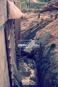
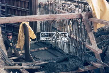
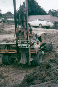
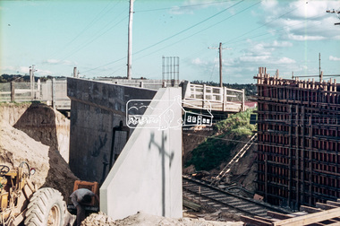
Slide, Sherbourne Road overpass, Briar Hill, North Abutment, 3 September 1970, 1970
Arrow compacting backfill Construction of new realigned Sherbourne Road railway overpass following realignment construction works for intersection of Sherbourne Road and Para Road.35 mm colour positive transparency Mount - Agfacolor Service (Blue)briar hill, bridge construction, overpass, para road, railway bridge, road construction, sherbourne road -
 Eltham District Historical Society Inc
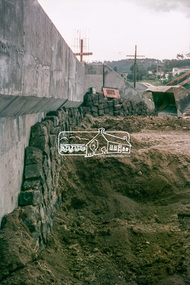
Slide, Sherbourne Road overpass, Briar Hill, North Abutment, 3 September 1970, 1970
Construction of new realigned Sherbourne Road railway overpass following realignment construction works for intersection of Sherbourne Road and Para Road.35 mm colour positive transparency Mount - Agfacolor Service (Blue)briar hill, bridge construction, overpass, para road, railway bridge, road construction, sherbourne road -
 Eltham District Historical Society Inc
Slide, Sherbourne Road overpass, Briar Hill, North Abutment, c.October 1970, 1970
Construction of new realigned Sherbourne Road railway overpass following realignment construction works for intersection of Sherbourne Road and Para Road.35 mm colour positive transparency Mount - Agfacolor Service (Blue)briar hill, bridge construction, overpass, para road, railway bridge, road construction, sherbourne road -
 Eltham District Historical Society Inc
Slide, Looking north along Main Road from intersection of Brougham Street, Eltham, c.1975, 1975c
Looking up to present day Cafe Zen Den then operated as a nursery35 mm colour positive transparency Mount - Agfacolor Service (Blue)brougham steet, cafe zen den, eltham, eltham courthouse, main road -
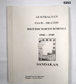 Bendigo Military Museum
Booklet - BOOKLET OF POW DEATHS AT SANDAKAN, Extraction from Don Wall's book - "Sandakan - The Last March", "AUSTRALIAN/ POW DEATHS/ BRITISH NORTH BORNEO/1942-1945/ SANDAKAN", c 1988
Booklet information "Extracted from Don Wall's book - Sandakan - The Last March" .Soft cover booklet - facsimile. Cover - cardboard, black print on cover, white background. Illustration - front, small black print of a soldier with bugle with cemetery scene. Binding tape. Pages 148 to 181 copied into booklet paper. End papers - printed colour triangular shaped images.books, history, ww2, sandakan -
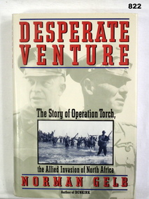 Bendigo Military Museum
Book, Norman Gelb, Desperate Venture - The Story of Operation Torch, the Allied Invasion of North Africa, 1992
Red and grey hard cover book with dust jacket. Dust jacket sepia photo background of 2 officers plus black & white photo of soldiers coming ashore from a boat.Written on title page in pen: Donated by Bendigo Y Mens Clubbooks, military, history -
 Phillip Island and District Historical Society Inc.
Book, BROWNELL, Henry, North and South America illustrated, 1861-2
Labelled 'Cowes Free Public Library', 'Phillip Island Historical Society, Cleeland Bequest'. -
Phillip Island and District Historical Society Inc.
Book, Gruffydd, W.J, North Wales and the Marches / W.J. Gruffydd, 1951
Labelled 'Himmer Bequest'. Stamped 'Cowes Public Library'. -
 Greensborough Historical Society
Document - Folder of Documents, Greenhills and North Greensborough Progress Association, 1967-1970, 1967-1970
Folder of notes collected by Councillor Laurie Svendsen during the period 1967-1970. Contains letters, minutes of meetings, newsletters, mainly in relation to street construction in the Greenhills area of Greensborough.Manilla folder containing typed and handwritten documents.greenhills and north greensborough progress association, laurie svendsen, greenhills progress associatiion -
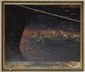 Mission to Seafarers Victoria
Painting, Ian Parry, Night Time at North Wharf, 1990
Ian Parry (born 1947) is a Melbourne-born artist living in Tasmania, active since 1974 and collected by National and State Collections. He was winner of the 1990 ACTA Maritime art Prize. He also took part in 2006, to the ANL Art Prize organised each year at the Mission since 2003. In his biography on his website: Ian Parry was born into a family of seafaring descent. His extensive career as a respected practising artist and teacher, has uniquely included a fishing fleet apprenticeship and years as a single handed fisherman in Bass Strait. "In the early 70's when I first showed at the renowned Powell St gallery in Melbourne, the paintings were large, abstract, with allusion to the experience of the world of water, sky and land. My visual world has always been permeated with the wet parts of this place and continues to be so to this day. Maritime and geological charts and the daily necessity of plotting a course, appear in paintings where necessary, as a means of getting a schematic representation of the subject into play, trying to free the work from the tyranny of the horizon line but frequently returning. Now-a-days I am returning to abstraction, making paintings that allow me free rein with colour and composition, aiming for a sense of permanence and independence in each work." Maritime ArtLarge moulded gilt wood frame, non glazed painting of shipping, oil on canvasSignature and date bottom right corner: "Parry 89"p & o nedloyd, shipping, melbourne ports, docklands, wharfside, wharves, ian parry, maritime art, acta maritime art prize, artwork-paintings -
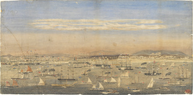 Mission to Seafarers Victoria
Print - Reproduction, Wilbraham Frederick Evelyn Liardet, View of the North Shore, Port of Melbourne, 1862
Liardet, W. F. E. (Wilbraham Frederick Evelyn), 1799-1878 depicts the busy port of Melbourne showing many types of ships and the Bethel Church built in 1860 on the Custom House land. The church replaced the Bethel ship which sank in February 1860.This watercolour along with the Francois Cogne print from 1863, "Sandridge from Hobson's Bay, and the engraving "A Bird's-eye View Of Melbourne From Sandridge" dating from 1882, is a rare depiction fo the Bethel church. In 1887, the church was demolished to erect the building still standing on the corner of Nott Street and Beach Road.wilbraham liardet, sandridge, port, ships, port melbourne, hobsons bay, bethel church, reverend kerr johnston, 1812-1887, missions to seamen, 1862, customs house -
 Greensborough Historical Society
Map, Melbourne and Metropolitan Board of Works. Survey Division, MMBW, Yarra 2500 / 12.22. Watsonia North, 1978_03
Melbourne and Metropolitan Board of Works. Yarra 2500 [base map]. 12-22, Parishes of Keelbundora 2856, Municipalities of Whittlesea 239 and Diamond Valley 257. Shows street names, easement sizes, lot numbers, lodged plan numbers, names of prominent features, contour values, creek or river names. Watsonia Railway Station and environs. Prominent streets: Edmund Rice Parade and Macorna Street. Includes Christian Brothers Edmund Rice College and Janefield Special School sites and "proposed future freeway" (now Metropolitan Ring Road).MMBW Map in 1:2500 [scale] series. Cream parchment with green tape reinforcing on edges and punched holes on left edge.mmbw, melbourne and metropolitan board of works, shire of diamond valley, watsonia - maps, bundoora - maps -
 Greensborough Historical Society
Map, Melbourne and Metropolitan Board of Works. Survey Division, MMBW, Yarra 2500 / 12.21. Watsonia North, 1979_02
Melbourne and Metropolitan Board of Works. Yarra 2500 [base map]. 12-22, Parish of Keelbundora 2856, Municipality of Diamond Valley 257. Shows street names, easement sizes, lot numbers, lodged plan numbers, names of prominent features, contour values, creek or river names. Watsonia Railway Station and environs. Prominent streets: Grimshaw Street, William Street and Macorna Street. Includes former Institute of Social Welfare (now Loyola College) Lines Reserve and Binnak Park.MMBW Map in 1:2500 [scale] series. Cream parchment with green tape reinforcing on edges and punched holes on left edge.mmbw, melbourne and metropolitan board of works, shire of diamond valley, watsonia - maps, bundoora - maps -
 Greensborough Historical Society
Advertising Leaflet, 9 Darren Avenue Watsonia North, 2012_12
9 Darren Avenue Bundoora. 3 bedroom home, private sale, sold December 2012 for $466,000Real estate advertising leaflet, 1 sheet, printed in colour both sidesdarren avenue bundoora -
 Greensborough Historical Society
CD-ROM, North Suburban World War One Resources, Brian Membrey, 2014_
CD of World War I resources compiled by Brian Membrey and available on Internet.1 cd-rom.world war i, brian membery -
4th/19th Prince of Wales's Light Horse Regiment Unit History Room
Book, Notes on North American Equipment & Stores Section J Ammunition, 1942
Hard covered book covering small arms, aircraft, artillery and armoured ammunitionsammunition, usa -
 Eltham District Historical Society Inc
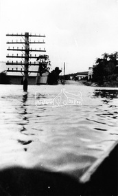
Photograph, Warrandyte. Main Road looking north toward Hotel, c.1928
Source: Mrs. E.M. Jackson, Pigeon Bank, Kangaroo GroundThis photo forms part of a collection of photographs gathered by the Shire of Eltham for their centenary project book,"Pioneers and Painters: 100 years of the Shire of Eltham" by Alan Marshall (1971). The collection of over 500 images is held in partnership between Eltham District Historical Society and Yarra Plenty Regional Library (Eltham Library) and is now formally known as the 'The Shire of Eltham Pioneers Photograph Collection.' It is significant in being the first community sourced collection representing the places and people of the Shire's first one hundred years.Digital imagesepp, shire of eltham pioneers photograph collection, warrandyte, floods -
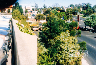 Eltham District Historical Society Inc
Photograph, View from Greensborough Plaza just north of Lorimer Street looking south to Grimshaw Street, c.1986, 1986c
Colour photograph originally located in a magnetic style album titled 'Greensborough Bypass 1990s 5' suffering significant degradation. No information contained in album or on reverse of photos except where noted. Relocated to archival photosafe storage.greensborough bypass, road construction, greensborough, greensborough plaza, lorimer street, grimshaw street -
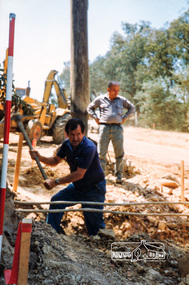 Eltham District Historical Society Inc
Photograph, Bruno, the man in charge of the road construction, Ryans Road, Eltham North, 1983, 1983
Originally contained in a 'magnetic' photo album believed to have been donated by Mr Eric Stephenson, Jingalong, 110 Ryans Road, Eltham, Vic. 3095; relocated to archival safe storage.Colour photographeltham north, road construction, ryans road -
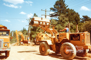
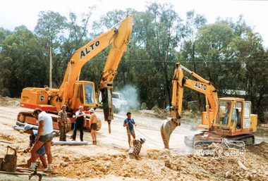 Eltham District Historical Society Inc
Photograph, Road construction, Ryans Road, Eltham North, 1983, 1983
Originally contained in a 'magnetic' photo album believed to have been donated by Mr Eric Stephenson, Jingalong, 110 Ryans Road, Eltham, Vic. 3095; relocated to archival safe storage.Twelve colour photographseltham north, road construction, ryans road -
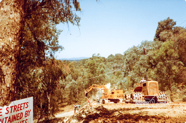 Eltham District Historical Society Inc
Photograph, Road construction near Progress Road, Ryans Road, Eltham North, 1983, 1983
Originally contained in a 'magnetic' photo album believed to have been donated by Mr Eric Stephenson, Jingalong, 110 Ryans Road, Eltham, Vic. 3095; relocated to archival safe storage.Four colour photographseltham north, road construction, ryans road, progress road -
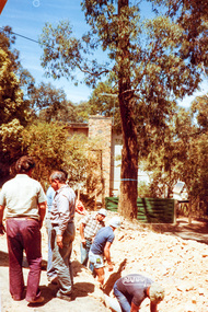
 Eltham District Historical Society Inc
Photograph, Road construction near 'Jingalong', Ryans Road, Eltham North, 1983, 1983
Originally contained in a 'magnetic' photo album believed to have been donated by Mr Eric Stephenson, Jingalong, 110 Ryans Road, Eltham, Vic. 3095; relocated to archival safe storage.Four colour photographseltham north, road construction, ryans road, jingalong -
 Eltham District Historical Society Inc
Photograph, Ross Johnston and road construction near 'Jingalong', Ryans Road, Eltham North, 1983, 1983
Originally contained in a 'magnetic' photo album believed to have been donated by Mr Eric Stephenson, Jingalong, 110 Ryans Road, Eltham, Vic. 3095; relocated to archival safe storage.Colour photographeltham north, road construction, ryans road, jingalong, ross johnston -
 Eltham District Historical Society Inc
Photograph, Road construction in front of 'Jingalong', 110 Ryans Road, Eltham North, 1983, 1983
Originally contained in a 'magnetic' photo album believed to have been donated by Mr Eric Stephenson, Jingalong, 110 Ryans Road, Eltham, Vic. 3095; relocated to archival safe storage.Colour photographeltham north, road construction, ryans road, jingalong, 110 ryans road -
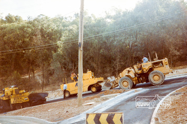 Eltham District Historical Society Inc
Photograph, Putting on the bitumen, road construction, Ryans Road, Eltham North, 1983, 1983
Originally contained in a 'magnetic' photo album believed to have been donated by Mr Eric Stephenson, Jingalong, 110 Ryans Road, Eltham, Vic. 3095; relocated to archival safe storage.Three colour photographseltham north, road construction, ryans road