Showing 4020 items
matching surveying
-
 Federation University Historical Collection
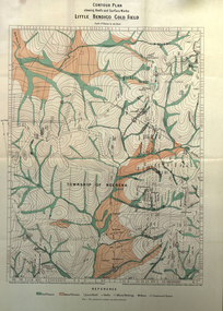
Book, Report on the Little Bendigo or Nerrena Gold-Field, Ballarat, 1901, 1901
Blue soft covered foolscap book of 4 pages. The book includes a folded, colour contour plan shewing reefs and Surface Works Little Bendigo Gold Field and an Underground Survey of Mines, Metropolitan, Monte Cristo Linelittle bendigo, nerrena, h.s. whitelaw, william baragwanath, geology, monte christo, monte cristo, neerena, nerrina, plans, mining cgt -
 Federation University Historical Collection
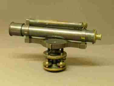
Equipment - Scientific Instruments, Level (Dumpy)
Surveying level - long bubble level on top. Magnet, compass under telescope. No crosshairs. External focussing. Four levelling screws. No transverse level. Housed in a polished timber storage box. Fits tripod Catalogue Number 429.scientific instruments, level, dumpy -
 Bendigo Historical Society Inc.
Map - NEILBOROUGH : COUNTY OF BENDIGO, 13-10-27
Map. Neilborough, County of Bendigo, Tandarra, Whirrakee, Huntly, Nerring, Yarraberb, Yallook, Photo-Lithographed at the Department of Lands and Survey, Melbourne by W.J. Butson 13-10-27, Price 1/- (number 77 in map cupboard 1)W.J. Butson.map, bendigo, neilborough -
Bendigo Historical Society Inc.
Map - MANDURANG : COUNTY OF BENDIGO, 1962
Map. Mandurang, County of Bendigo. Sandhurst, Strathfieldsaye, Sedgwick, Lockwood. By authority A.C. Brooks, Government Printer, Melbourne. Drawn and Reproduced at the Department of Lands and Survey, Melbourne, 1962, Price 2/-. (number 67 in map cupboard 1)A.C. Brooks, Government Printer, Melbourne.map, bendigo, mandurang -
Bendigo Historical Society Inc.
Map - TALAMBE : COUNTY OF BENDIGO, 21-3-27
Map. Talambe, County of Bendigo, Hayanmi, Calivil, Pompapiel, Yallook, Tandarra, Dingee. Photo-Lithographed at the Department of Lands and Survey, Melbourne, by W.J. Butson 21-3-27, Price 2/-. (number 27 in map cupboard 1)W.J. Butsonmap, bendigo, talambe -
 Bendigo Historical Society Inc.
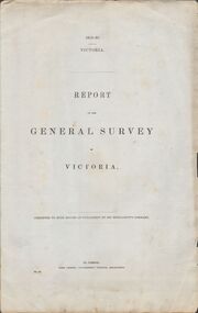
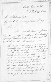
Document - VICTORIA SURVEY REPORT 1859 TO 60
Four page report presented to both houses of parliament by Surveyor General CH W Ligar dated 1859-60. Object of survey to establish the best method of delineating the boundaries of new allotments in the colony. Geodetic method recommended.bendigo, history, allottment survey -
Bendigo Historical Society Inc.
Map - CAMPBELL COLLECTION: BENDIGO AND DISTRICT MAPS, 11-2-37
Map. Parish of Shelbourne, County of Bendigo. Scale 40 chains to 1 inch. Drawn and reproduced at the Department of Lands and Survey, Melbourne, Victoria. Price 2/-.11-2-37. By Authority H.J. Green, Government Printer, Melbourne.H.J. Green, Government Printermap, bendigo, agricultural lands -
Bendigo Historical Society Inc.
Map - EPPALOCK : COUNTY OF BENDIGO, 2-11-14
Map. Eppalock, County of Bendigo,Lyell, Sedgwick, Strathfieldsaye, Axedale, Knowsley, Kimbolton. Photo-Lithographed at the Department of Lands and Survey, Melbourne by W.J. Butson, 2-11-14. Price 1/-. (number 39 in map cupboard 1)W.J. Butson.map, bendigo, eppalock -
Bendigo Historical Society Inc.
Map - YARRAYNE : COUNTY OF BENDIGO, 6-1-32
Map. Yarrayne, County of Bendigo, Janiember East; Pompapiel, Salisbury, Bridgewater, Salisbury West, Powlett. Photo-Lithographed at the Department of Lands and Survey, Melbourne. Price 2/-. 6-1-32. (number 12 in map cupboard 1)H.J. Green, Government Printermap, bendigo, yarrayne -
Bendigo Historical Society Inc.
Map - PANNOOMILLOO : COUNTY OF BENDIGO, 1957
Map. Pannoomilloo, County of Bendigo, Milloo, Warragamba, Diggorra, Pannoobamawm. Drawn and reproduced at the Department of Lands and Survey, Melbourne,1957. Price 2/-. By Appointment W.M. Houston, Government Printer, Melbourne. (number 3 in map cupboard 1)W.M. Houston, Government Printermap, bendigo, pannoomilloo -
 Villa Alba Museum
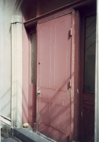
Photograph - Painted external door, c.1987
Built for William and Anna-Maria Greenlaw in the early 1880s, and with interiors decorated by the Paterson Bros, Villa Alba remained in private ownership until 1949. From 1950, the house was owned by a number of institutions. By 1984, the Villa Alba Preservation Society had been formed, and three years later, the Mount Royal Hospital granted a 25-year lease to Kew Council. In 2004, the title to Villa Alba was passed by the Victorian Government to The Villa Alba Museum Incorporated. The Museum, at 44 Walmer Street, Kew, is now a cultural institution committed to the collection, study and display of 19th century interior decorative finishes, and the components of 19th and 20th century interior decoration.This is one of a number of historically and aesthetically significant photos of the interiors and exterior of Villa Alba when it was still owned by the Mount Royal Hospital, showing twentieth century accretions and deterioration of the historic fabric of the building. This was a benchmark survey against which future conservation and restoration activities can be measured.In December 1987, Mockridge Stahle & Mitchell Pty Ltd Architects prepared ‘Villa Alba Survey: A Report on the fabric for Mount Royal Hospital’ of which this photograph is a part. Photo of a raised painted wooden door at the back of Villa Alba.villa alba museum, conservation photographs, victorian architecture, external doors -
 Villa Alba Museum
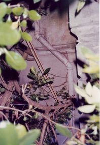
Photograph - Exterior pipe obscured by foliage, c.1987
Built for William and Anna-Maria Greenlaw in the early 1880s, and with interiors decorated by the Paterson Bros, Villa Alba remained in private ownership until 1949. From 1950, the house was owned by a number of institutions. By 1984, the Villa Alba Preservation Society had been formed, and three years later, the Mount Royal Hospital granted a 25-year lease to Kew Council. In 2004, the title to Villa Alba was passed by the Victorian Government to The Villa Alba Museum Incorporated. The Museum, at 44 Walmer Street, Kew, is now a cultural institution committed to the collection, study and display of 19th century interior decorative finishes, and the components of 19th and 20th century interior decoration.This is one of a number of historically and aesthetically significant photos of the interiors and exterior of Villa Alba when it was still owned by the Mount Royal Hospital, showing twentieth century accretions and deterioration of the historic fabric of the building. This was a benchmark survey against which future conservation and restoration activities can be measured.In December 1987, Mockridge Stahle & Mitchell Pty Ltd Architects prepared ‘Villa Alba Survey: A Report on the fabric for Mount Royal Hospital’ of which this photograph is a part. Photo of cast exterior water pipe party obscured by vegetation.villa alba museum, conservation photographs, victorian architecture, drain pipes -
Clunes Museum
Map - MAPS/ DOCUMENTS, CIRCA 1857
COLLECTION OF DOCUMENTS (COPIES OF10 MAPS AND DIAGRAMS OF TOURAAL PURCHASED UNDER PREEMPTIVE RIGHT BY DONALD CAMEROM 17TH FEBRUARY, 1857. COUNTY OF TALBOT - GOLDFIELD'S SURVEY PLAN NO.1 CLUNES COUNTY OF TALBOT. GLENDONALD - CRESWICK/CLUNES.local history, mining -
Clunes Museum
Document - REPORTS
E J Dunn described the geology of the mining in an around Clunes and a recommendation for re-commencing mining operations in Clunes 1909.1 PHOTOCOPY OF A PAGE SHOWING RETURNS MADE BY MINING SURVEYORS AND REGISTERS TAKEN FOR THE QUARTER ENDED 31ST MARCH 1875 .2 & .3 PHOTOCOPY OF TWO PAGES OF A GEOLOGICAL SURVEY COMPLETED FOR THE GOVERNMENT (SENT IN 17/5/1909)NILlocal history, document, mining -
Whitehorse Historical Society Inc.
Map, Nunawading, 1972
Variation of original 1864 map with a number of additions and bold marking of an area including Forest Hill, Vermont and Vermont South as 'Proclaimed survey area No 21 May 1972 2826. Marked as P M Noting Melb SeriesVariation of original 1864 map with a number of additions and bold marking of an area including Forest Hill, Vermont and Vermont South as 'Proclaimed survey area No 21 May 1972 2826. Marked as P M Noting Melb Series.Variation of original 1864 map with a number of additions and bold marking of an area including Forest Hill, Vermont and Vermont South as 'Proclaimed survey area No 21 May 1972 2826. Marked as P M Noting Melb Seriesmaps, shire of blackburn and mitcham, forest hill, vermont, vermont south -
 Whitehorse Historical Society Inc.
Letter - Document, Roads, 1/04/1868
Letter to C. Hodgkinson, Assistant Commissioner of Lands Survey from William H. Watkins, Bailiff of Crown Lands, dated 1 April 1868 re alternative locations of road through Messrs Cook or Cummings land in Nunawading.marshall's gully, cook, william, cumming (mr), watkins, william h, hodgkinson, clement, roads and streets -
 Otway Districts Historical Society
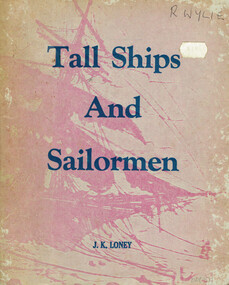
Book, J.K. Loney, Tall ships and sailormen
Compiled from newspapers, official records, registers, books and unpublished diaries Tall ships and sailormen provides information for those interested in the marine history of Victoria.Tall ships and sailormen. A concise survey of Victoria's early maritime history. J.K. Loney. nl; J.K. Loney; nd. ii, 103 p.; illus, maps, bibliography. Soft cover. ISBN 0 909244 02 2victoria; ships; sailors; j.k. loney; history; -
Bendigo Historical Society Inc.
Map - WANURP: COUNTY OF BENDIGO, 1/12/33
Map. Wanurp, County of Bendigo, Terrick Terrick East, Mitiamo, Dingee, Milloo, Pannoobamawm. L422+. Photo-Lithographed at the Department of Lands and Survey, Melbourne, Price 2/-. 1/12/33 ( number 411 in Map Cupboard 1 )H.J. Green, Government Printerbendigo, hospital -
 Bendigo Historical Society Inc.
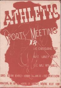
Programme - THE BROOK AND ANDERSON FORTUNA COLLECTION: ATHLETIC SPORTS MEETING
LHQ Cartographic Company, Australian Survey Corps (OC Maj WM Sarll). Athletic sports meeting, Upper Reserve, Bendigo. Monday 31stJanuary 1944, first event at 12.45pm Eight pages listing all the events and the participants.military, world war 2 -
Canterbury History Group
Article, Don Gibb, The Elgar's Special Survey
Copy of a talk given by Don Gibb to the Canterbury History Group in June 2015 on the Elgar Survey which will be the basis of the second chapter of his forthcoming book on the social history of Canterbury. Includes maps and a list of the first Boroondara ratepayers.canterbury, mcwilliam. gwen, land subdivision, port phillip district, maps, gibb> don -
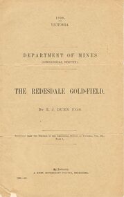 Bendigo Historical Society Inc.
Document - MCCOLL, RANKIN AND STANISTREET COLLECTION: THE REDESDALE GOLDFIELD, 1909
1909 report from the Department of Mines Geological Survey on the Redesdale Goldfield by E. J. Dunn. F.G.S. Reefs mentioned are the Horseshoe Bend Reef, Linda Reef, Bill Smith's workings, the Ben Guy Reef and the Amelia ReefDepartment of Minesgold mining, miners' safety cage, redesdale goldfield, gold mining, redesdale. -
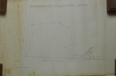 Bendigo Historical Society Inc.
Plan - MARKS COLLECTION: PLAN OF UNDERGROUND WORKINGS CINDERELLA COMPANY, JOHNSON'S REEF
Plan on heavy parchment paper: on top of plan 'Plan of the underground workings Cinderella Company, Johnson's Reef' Lh side of plan 'Kent Company's Ground' on bottom: Tipper and Company. Written on bottom surveyed 13/7/64.bendigo, mining, cinderella company -
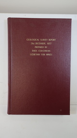 Kiewa Valley Historical Society
Book - Geographical Survey, Geographical Survey Report 31st Dec. 1977 prepared by Thos. Couchman Secretary for Mines
Office of Mines published progressive reports on the Geological Survey of parts of Victoria.This book includes a chapter on 'Dargo and Bogong' Pages 96 - 117 and includes a fold out map of this area. These pages show heavy use.Hard deep red cover with gold printed title located at the centre top. Bound with spine blank. 217 pages. Date 1878 First chapter and some pages have pencil marks including page 97.geological survey 1878, dargo, bogong -
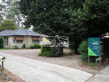
 Eltham District Historical Society Inc
Photograph, Jim Connor, Avenue of Honour, Main Road, Eltham, 14 Jan 2017
Eltham Gateway, Webster Survey Group, 662 Main Road, ElthamTomorrow's history documented todayeltham, jim connor collection, main road, avenue of honour, eltham gateway, webster survey group -
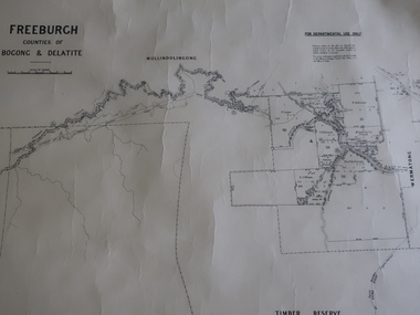 Kiewa Valley Historical Society
Map - Freeburgh - Counties of Bogong and Delatite
Drawn and reproduced at the Dept. of Lands and Survey, Melbourne, Victoria November 1948Black and white map of Freeburgh, County of Bogong and Delatitefreeburgh, map county of bogong and delatite -
Moorabbin Air Museum
Document (Item) - Mirage Field Service Surveys 1965-1968
Description: Mirage Field Service Surveys Defect Reports Level of Importance: . -
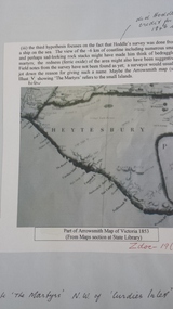 Peterborough History Group
Document - Peterborough survey, Heytesbury District
About Peterborough town and the surrounding Council districts, coastal survey and mapshistory of the development of the townMaps, photocopiesflaxman hill, peterborough history, heytesbury, peterborough 3270 -
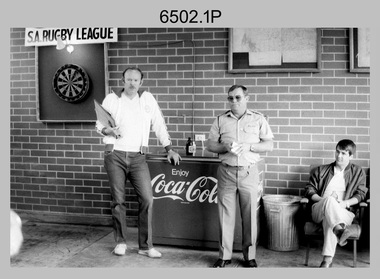 Bendigo Military Museum
Photograph - 4th Field Survey Squadron – MAJ Don Taylor Farewell, Keswick Barracks, Adelaide SA, 1986
This is a set of 21 photographs of a 4th Field Survey Squadron function held in 1986 to farewell its OC MAJ Don Taylor. MAJ Taylor served 27 years in the Australian Regular Army from 1960 to 1987.This is a set of 21 photographs of a 4th Field Survey Squadron function to farewell its OC MAJ Don Taylor, at Keswick Barracks, Adelaide SA in 1986. The black & white photographs are on 35mm negative film and are part of the Army Survey Regiment’s Collection. The photographs were scanned at 96 dpi. .1) - Photo, black & white, 1986. L to R: SSM WO1 Bill Griggs, OC MAJ Don Taylor, unidentified. .2) - Photo, black & white, 1986. Back row L to R: SGT Wally Chilcott, unidentified (x2), CPL Peter McCurdy, unidentified. Front row L to R: LT Greg Oaten CSC, LT Malcolm Hentschel, SPR Steve Nokes. At front L to R: CPL John Ratcliffe, OC MAJ Don Taylor, SSM WO1 Bill Griggs. .3) - Photo, black & white, 1986. L to R: SSM WO1 Bill Griggs, CPL John Ratcliffe, OC MAJ Don Taylor, George Ricketts, unidentified (x2). .4) - Photo, black & white, 1986. L to R: LT Malcolm Hentschel, unidentified (x2), CPL John Ratcliffe, CPL Peter Hardy, SSM WO1 Bill Griggs, OC MAJ Don Taylor. .5) - Photo, black & white, 1986. L to R: LT Greg Oaten CSC, LT Malcolm Hentschel, unidentified (x2), CPL John Ratcliffe, CPL Peter Hardy, SSM WO1 Bill Griggs, OC MAJ Don Taylor. .6) - Photo, black & white, 1986. L to R: SGT Bill Tewson, SGT Bob Croxton, CPL Dave Irving, WO2 Bob Rogister, unidentified (x3), SSGT Cam Chapman, Chris Hills, CPL Roger Graf. .7) - Photo, black & white, 1986. L to R: SSM WO1 Bill Griggs, LT Malcolm Hentschel, OC MAJ Don Taylor, SGT Mick Hogan. .8) - Photo, black & white, 1986. L to R: unidentified, LT Malcolm Hentschel, SSM WO1 Bill Griggs, Mick Hogan’s daughter? OC MAJ Don Taylor, SGT Mick Hogan. .9) - Photo, black & white, 1986. L to R: unidentified, SSM WO1 Bill Griggs, unidentified, SGT Bill Tewson, OC MAJ Don Taylor. .10) - Photo, black & white, 1986. L to R: unidentified, SGT Bill Tewson, SSM WO1 Bill Griggs, OC MAJ Don Taylor, SGT Mick Hogan and his wife. .11) - Photo, black & white, 1986. L to R: CAPT Steve Cooper, SSM WO1 Bill Griggs, OC MAJ Don Taylor. .12) - Photo, black & white, 1986. L to R: unidentified, CAPT Steve Cooper, SSM WO1 Bill Griggs, OC MAJ Don Taylor, SGT Mick Hogan. .13) - Photo, black & white, 1986. L to R: unidentified, CPL Peter McCurdy, SGT Bill Tewson, CAPT Steve Cooper, OC MAJ Don Taylor, SSM WO1 Bill Griggs. .14) - Photo, black & white, 1986. L to R: OC MAJ Don Taylor, unidentified (x5), CPL Chris ‘Charlie’ Brown, unidentified (seated), SPR Damian Killeen, remainder unidentified. .15) - Photo, black & white, 1986. L to R: unidentified, LT Malcolm Hentschel, SPR Steve Ellis, unidentified (x5), CPL Roger Graf. .16) - Photo, black & white, 1986. Unidentified personnel. SPR Richard Cocker takes aim at the dart board. 4 Fd Svy Sqn Farewell 1986. .20) - L to R: unidentified, CPL Peter Hardy, CPL Tracey (Beckwith) Phillips, unidentified (x4), CAPT Steve Cooper, Ken Jeffery, remainder unidentified. .21) - L to R: CPL C. Rimmington, SGT H. Young. .17) - Photo, black & white, 1986. L to R: SPR Steve Nokes, LT Greg Oaten CSC, SPR Simon Reynolds, Chris Hills, LT Malcolm Hentschel, SGT Wally Chilcott. .18) - Photo, black & white, 1986. L to R: unidentified, SPR Richard Cocker, CPL Peter McCurdy, LT Greg Oaten CSC, SPR Simon Reynolds, SGT Bob Croxton. .19) - Photo, black & white, 1986. L to R: CPL Chris ‘Charlie’ Brown, Mrs Kath Rogister, WO2 Bob Rogister, SSGT Cam Chapman, CAPT Terry Lord, unidentified. .20) - Photo, black & white, 1986. L to R: unidentified, CPL Peter Hardy, CPL Tracey (Beckwith) Phillips, unidentified (x4), CAPT Steve Cooper, Ken Jeffery, remainder unidentified. .21) - Photo, black & white, 1986. L to R: CPL C. Rimmington, SGT H. ’Jock’ Young..1P to .21P – There are no personnel identified. ‘MAJ Don Taylor’s SQN Farewell. 1986’ annotated on negatives sleeve.royal australian survey corps, rasvy, 4 fd svy sqn -
 Federation University Historical Collection
Book, Mining Engineers Handbook Volume 1 & 2, 1941
The book was used by Charles Bacon who studied at the University of Nevada in the late 1930s/early 1940s. Bacon worked at Bunker Hill Mines and Kellogg Idaho, before arriving in Australian in 1951. He worked for CN Myers, a company involved with paper converting. CN Myers was a family business (on Charles Bacon's maternal line). Robert Peele was Professor Emeritus of mining Engineering at the School of Mines, Columbia University.Maroon hardcovered books. .1) Volume 1 - Chapters include Mineralogy, Geology and Mineral Deposits, Earth Excavation, Explosives, Rock Excavation, Tunneling, Shaft Sinking in Rock, Shaft sinking in Unstable and Waterbearing Ground, Boring, Underground Transport, Mine Ventilation. .2) Volume 2 - Chapers include Compressed Air Practice, Electric Power for mine Service, Surveying,Underground Surveying, Mine Geologic Maps and models, Cost of mining, Mining Laws, Ore sampling, Assaying, Aerial Tramways and Cableways, Gold Amalgamation and Cyanidation, etc.Inside front cover "Charles Bacon"charles bacon, mining engineering, mining, engineering, university of nevada, mackay school of mines, explosives, timbering