Showing 2558 items
matching aerial
-
 Glenelg Shire Council Cultural Collection
Photograph - Photograph - NNW of Portland Harbour, 21/03/1972
Port of Portland Authority archives.Front: (no inscriptions) Back: (no inscriptions)port of portland archives -
Glenelg Shire Council Cultural Collection
Photograph - Photograph - Aerial view of CSR Softwoods plant, Portland, c. 1974
Port of Portland CollectionUnframed, black and white aerial photograph, taken from the N.W., of C.S.R. Softwoods plant, Darts Road Portland under construction, various wool stores; skin sheds at Thomas Borthwick & Sons abattoir.Front: (no inscriptions) Back: (no inscriptions)port of portland archives, aerial photography, portland harbour -
Glenelg Shire Council Cultural Collection
Photograph - Photograph - aerial view of Portland coastline, c. 1954
Black and white aerial photograph of coastline around Portland. Black border, scale all sides, 5 rows of 3 't' at regular intervals. 10% ocean, 90% land. See 'Other Information'Front: '820- 52' - handwritten, white, border 'RUN 6' 'PORTLAND', printed, white, borderport of portland, aerial photography, south west coastline -
Glenelg Shire Council Cultural Collection
Photograph - Photograph - aerial view of Portland, c. 1954
Black and white aerial photograph of coastline around Portland. Black border, scale all sides, 5 rows of 3 't' at regular intervals. 25% ocean, 75% land. See 'Other Information'Front: '820 - 50' - handwritten, white, border 'RUN 6' 'PORTLAND', printed, white, borderaerial photography, central portland, portland harbour, south west coastline -
Glenelg Shire Council Cultural Collection
Photograph - Photograph - aerial view of Portland, c. 1954
Black and white aerial photograph of coastline around Portland. Black border, scale all sides, 5 rows of 3 't' at regular intervals. Mostly ocean, small area of land lower left.Front: '820-6' -- handwritten, white, lower border 'RUN 5' 'PORTLAND', printed, white, lower borderaerial photography, central portland, portland harbour, south west coastline -
Glenelg Shire Council Cultural Collection
Photograph - Photograph - Aerial photograph of coastline around Portland, Victoria, c. 1954
Black and white aerial photograph of coastline around Portland. Black border, scale all sides, 5 rows of 3 't' at regular intervals. Bottom 20% ocean, rest land, separated by beach.Front: '607 - 88' - handwritten, white, border 'RUN - 6 PORTLAND', printed, white, border -
Glenelg Shire Council Cultural Collection
Photograph - Photograph - aerial view of Portland, c. 1954
Black and white aerial photograph of coastline around Portland. Black border, scale all sides, 5 rows of 3 't' at regular intervals. Mostly ocean, small area of land, top left.Front: '607 - 49 ' - handwritten, white, border 'RUN 8' 'PORTLAND', printed, white, borderaerial photography, central portland, portland harbour, south west coastline -
Glenelg Shire Council Cultural Collection
Photograph - Photograph - aerial view of Portland, c. 1954
Black and white aerial photograph of coastline around Portland. Black border, scale all sides, 5 rows of 3 't' at regular intervals. Mostly ocean, small area of land, top centreFront: '607 - 50 ' - handwritten, white, border 'RUN 8' 'PORTLAND', printed, white, borderaerial photography, central portland, portland harbour, south west coastline -
Glenelg Shire Council Cultural Collection
Photograph - Photograph - aerial view of Portland, c. 1954
Black and white aerial photograph of coastline around Portland. Black border, scale all sides, 5 rows of 3 't' at regular intervals. Bottom third is ocean, the rest is land, separated by beach.Front: '607 - 89 ' - handwritten, white, border 'RUN - 6 PORTLAND', printed, white, borderaerial photography, central portland, portland harbour, south west coastline -
Glenelg Shire Council Cultural Collection
Photograph - Photograph - aerial view of Portland, c. 1954
Black and white aerial photograph of coastline around Portland. Black border, scale all sides, 5 rows of 3 't' at regular intervals. Bottom half ocean, top land, separated by beach.Front: '607 - 92 ' - handwritten, white, border 'RUN - 6 PORTLAND', printed, white, borderaerial photography, central portland, portland harbour, south west coastline -
Glenelg Shire Council Cultural Collection
Photograph - Photograph - aerial view of Portland, c. 1954
Black and white aerial photograph of coastline around Portland. Black border, scale all sides, 5 rows of 3 't' at regular intervals. Small strip of land across bottom. The rest is ocean.Front: '607 - 56 ' - handwritten, white, border 'RUN 7 PORTLAND', printed, white, borderaerial photography, central portland, portland harbour, south west coastline -
4th/19th Prince of Wales's Light Horse Regiment Unit History Room
Radio Set SR C-45, 1950's
A VHF radio for use in vehicles or as a truck & ground station. Consisting of three main units: the sender/receiver, the power supply unit (SUV), and an aerial tuning unit. Power supply 24 Volt DCRadio No A247, SUV No A 544radio, c-45, communications, signals -
Glenelg Shire Council Cultural Collection
Photograph - Photograph - NNW of Portland Harbour, 21/03/1972
Port of Portland Authority archives.Front: (no inscriptions) Back: (no inscriptions)port of portland archives, portland harbour, south portland, cape nelson, no6 berth construction, cresco fertilizer, s l patterson wharf -
Glenelg Shire Council Cultural Collection
Photograph - Photograph - NNW of Portland Harbour, 21/03/1972
Port of Portland Authority archives.Front: (no inscriptions) Back: (no inscriptions)port of portland archives, portland harbour, south portland, cape nelson, cresco fertilizer, s l patterson wharf -
Port Melbourne Historical & Preservation Society
Photograph - Aerial view of Station Pier, Port Melbourne on completion, Port Melbourne, 1930
Aerial photo of Station Pier on completion, 1930. Three colliers 'laid up' on east side and Weeroona (east) and Hygeia (west) laying at the wing piers. Shows the area set aside for Centenary Bridge.centenary bridge, melbourne harbor trust - port of melbourne authority, piers and wharves - station pier, transport - shipping, engineering - bridges, dumosa - collier, werribee - collier, ashridge - collier, ps weeroona, ps hygeia, transport - ferries -
 Port Melbourne Historical & Preservation Society
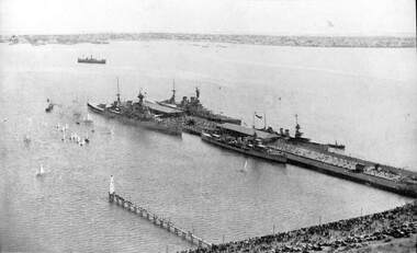
Photograph - Aerial view of HMS Hood (outer east), HMS Repulse (outer west) with escorts Delhi and Danae, Princes Pier, Port Melbourne, Mar 1924
(1) Aerial photographic view of Princes Pier with units of the British Navy alongside 17-25 March 1924. principal vessels are the HMS Hood (OE) and HMS Repulse (OW) with escorts Delhi and Danaepiers and wharves - princes pier, armed services - navy, vessels, hms hood, hms repulse, hms delhi, hms danae -
Port Melbourne Historical & Preservation Society
Photograph - Aerial view of HMS Repulse being berthed at outer west Princes Pier by tug James Patterson, Port Melbourne, Royal Australian Air Force (RAAF), 1924
Air Force aerial photos of the visit of HMS Hood and HMS Repulse 1924 04 - HMS Repulse being berthed at Outer West Princes Pier by tug James Patterson. New beacons are visiblepiers and wharves - princes pier, transport - shipping, armed services - navy, hms hood, hms repulse, ss james patterson -
Tatura Irrigation & Wartime Camps Museum
Photograph, Eildon Township, 1957
Taken by photographer for State Rivers and Water Supply Commission.Medium sized black and white photo. Aerial photograph - looking down on township in middle foreground - overflow dam to the right, middle distance - dam wall with reservoir beyond - mountain tops forming horizonOn frame below photo: "Eildon Township."victoria state rivers and water supply commission, eildon -
 Hume City Civic Collection
Photograph, 1972
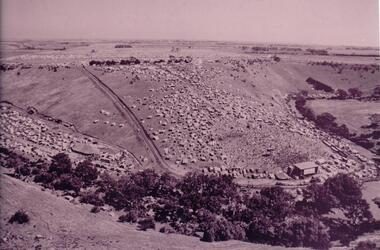
The photograph was taken during the 1972 Sunbury Pop Festival which was staged on a property owned by George Duncan. The site is on the banks of the Jacksons Creek between Sunbury and Diggers Rest.An aerial photograph of a crowd of people on a hillside and along a creek valley with a stage set up. On the LHS there is a large marquee surrounded by cars and pitched tents. There are trees around the creek and vast open paddocks in the distance.sunbury pop festival, jacksons creek, duncan, george, george evans collection -
 Bendigo Historical Society Inc.
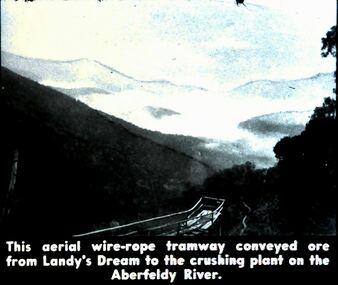
Slide - DIGGERS & MINING. DIGGERS AND MINERS, c1800s
Diggers & Mining. Diggers and miners. Walhalla - Gold Town. This aerial wire-rope tramway conveyed are from Landy's Dream to the plant on the Aberfeldy River. Markings: 18 995 WAL. Used as a teaching aid.hanimounteducation, tertiary, goldfields -
 Lakes Entrance Historical Society
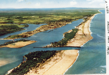
Photograph - Lakes Entrance, Kruger A F, 1960c
Colour photograph aerial view of the entrance from Bass Strait to the Gippsland Lakes, Australia. Shows extension to Bullock Island, town of Lakes Entrance, Cunninghame Arm and North Arm. Lakes Entrance Victoriaaerial photograph, islands, waterways, topography, township -
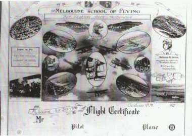 Port Melbourne Historical & Preservation Society
Photograph - Flight certificate given to passengers on Carey planes, 1920s
Sent by Carey's daughter Bertha Harvey during compilation of transport book "Linking "Us Together. (.01) lasercopy of aerial photo of Carey's Melbourne Air Service aerodrome on the Bend (Item .01 is absent from file as at Dec 2013) (.02) lasercopy of the Flight Certificate given to passengers on Carey planesfishermans bend, transport - aviation and aerodrome, r graham carey, melbourne air service -
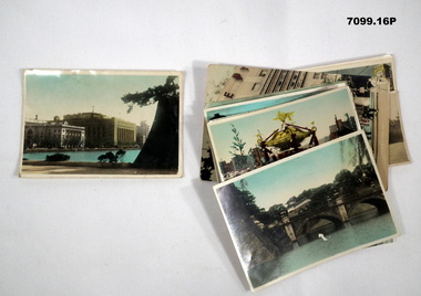 Bendigo Military Museum
Photograph - PHOTOGRAPHS, BCOF, JAPAN, possibly pre WW2
Items in the collection re Clarence Shearing, refer Cat No 7089.16P for his service details.Series of 16 colour enhanced photos various sizes of Japan. Eight have a text on the front cover or rear. Eight are of different buildings and place.On rear, "Sacred Cam at Shinto festival" "Aerial view Marunouchi the business centre of Tokyo" "Akamon (entrance) of Imperial Palace" On rear, "Entrance to Palace Tokyo" "Bridge Mijyubashi in Tokyo" "-abukiza (Theatre)"photographs, bcof, japan -
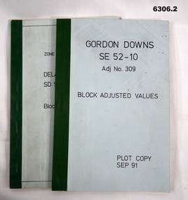 Bendigo Military Museum
Administrative record - Report on the Block Adjustment of the Gordon Downs and Delemere 1:250,000 Maps, Army Survey Regiment, 1 Sep 1991, .2 Jan 1988
All mapping produced at this time were produced using Aerial Photography. These booklets contain the adjusted mathematical solution to joining this group of photographs together..1 Blue covered booklet with green tape binding. Block adjusted values for Gordon Downs SE 52-10 1:250 000 map Adjustment number 309 Sep 1991 .2 Blue covered booklet with green tape binding. Block adjusted values for Delamere SD 52-16 1:250 000 map Adjustment number 272 Jan 1988royal australian survey corps, rasvy, fortuna, army survey regiment, army svy regt, asr -
Creswick Campus Historical Collection - University of Melbourne
Maps, 1967 - 1972
Maps of various subjects: Gunbower Island 1972. Barmah Forest 1967. Survey maps from aerial photography 1971 _Narnargoon.Tonimbuk. Gilwell & Beenak.Maps -
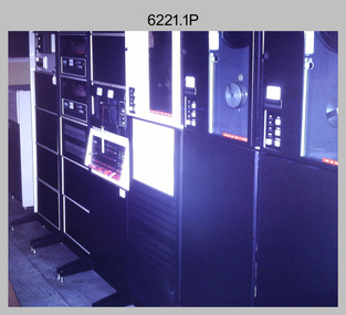 Bendigo Military Museum
Photograph - Aerotriangulation Production – Army Survey Regiment, Fortuna, Bendigo, c1970s to 1980s
This collection of 14 photos was most likely taken in the 1970s and 1980s in Air Survey Squadron. The PDP 11/70 minicomputer shown in photo .1P was the operating system introduced in 1977 as the mainframe system for the control of the APC4, aerial triangulation block adjustments, SORA OP Analytical Orthophoto control, APR Analytical Terrain Profile Recorder computation, graphics, and general computing. Technicians used the Wild A9 Stereocomparator shown in photo .2P to accurately measure between pass, tie, and survey control points on aerial photographs. The Zeiss D2 Planimat Stereoplotter shown in photos .3P to .4P was used for analytical orthophoto control. It was introduced in 1972-1973 The Zeiss (Jena) Stecometer analytic stereocomparator for air photography shown in photos .5P to .11P and .14P was introduced at Air Survey Squadron in 1963. Aerotriangulation production was expedited using computers for analytical photogrammetric processes. The technician accurately measured between pass, tie, and survey control points on aerial photographs. Wild PUG4 point transfer devices shown in photos .12P to .13P were introduced in c1968 superseding the PUG2 devices. PUG4 devices were used by technicians to stereoscopically view the photography containing the survey control points and the mapping aerial photography. The Control points were transferred from the control photography to the mapping diapositives of aerial photography by drilling their locations into the photographic emulsion.This is a set of 14 photographs of Air Survey Squadron personnel operating aerotriangulation equipment at the Army Survey Regiment at Fortuna, Bendigo, c1970s to 1980s. Photographs .1P to .13P were on 35mm colour slide film and scanned at 96 dpi. Photograph.14P was printed on photographic paper and was scanned at 300 dpi. They are part of the Army Survey Regiment’s Collection. .1) - Photo, colour, c1979, PDP-11 minicomputer. .2) - Photo, colour, c1970s, Unidentified technician operating a Wild A9 Stereocomparator. .3) - Photo, colour, c1970s, Zeiss D2 Planimat Stereoplotter. .4) - Photo, colour, c1970s, Zeiss D2 Planimat Stereoplotter, unidentified technicians. .5) - Photo, colour, c1970s, Zeiss D2 Planimat Stereoplotter, SGT Christopher Wardley. .6) - Photo, colour, c1970s, Zeiss D2 Planimat Stereoplotter. .7) to.9) - Photo, colour, c1970, Zeiss (Jena) Stecometer, unidentified technicians. .10) to.11) - Photo, colour, c1988, SPR Toni Wright operating a Zeiss (Jena) Stecometer. .12) - Photo, colour, c1970s, Wild PUG4 point transfer device, SPR John Shepard. .13) - Photo, colour, c1970s, Wild PUG4 point transfer device, SPR David Edwards. .13) - Photo, colour, c1970s, Wild PUG4 point transfer device, SPR David Edwards. .14) - Photo, colour, c1980, Zeiss (Jena) Stecometer, SGT Bruce Hammond.Some of the equipment is annotated on the frame of the 35mm slides.royal australian survey corps, rasvy, army survey regiment, army svy regt, fortuna, asr, aerotrig, photogrammetry -
 Bendigo Military Museum
Administrative record - AHQ Fd Svy Sect (Sth Comd Det) - Air Photo Liaison draft notes 1950, 14 Mar 1950
These notes indicate that the "Standard Specification for Aerial Photography RASvy" be revised, and that all liaison personnel be issued with a copy so that the required standard of photography can be adhered to.4 x A4 pages of typed notes, poorly photocopiedroyal australian survey corps, rasvy, fortuna, army survey regiment, army svy regt, asr -
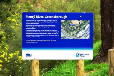 Greensborough Historical Society
Photograph - Digital image, Marilyn Smith, Plenty River bank stabilisation 2015, 16/08/2015
River bank stabilisation project along the Plenty River at Greensborough 2015, conducted by Melbourne Water. Project sign and close-up of aerial view of site.Digital copy of colour photographplenty river, melbourne water -
Glenelg Shire Council Cultural Collection
Souvenir - Tourism Booklet - 'Discovering Portland', Discovering Portland, n.d
Thirteen page booklet 'Discovering Portland', by Carol White. Glossy heavy card covers, lighthouse on front, aerial view of Portland Island, Dorset, UK on back. Coloured photos and descriptions of places of interest on Portland. -
Glenelg Shire Council Cultural Collection
Photograph - Photograph - Portland Smelter, c. 1980
Previously displayed in offices at the smelterFramed aerial photograph of Portland smelter taken in 1908's. Image shows Dutton way and Narrawong in the background. Gilt wooden frame. Glass covers photo. Brown paper on back of photo, hanging cord.Front: Back- Label for Gary Hayman, picture framer