Showing 2091 items
matching bendigo maps
-
 Bendigo Historical Society Inc.
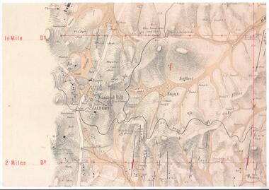
Map - DIAMOND HILL AREA
Copy of map of Diamond Hill area, with the Trig Station mid centre on map. Shafts, mines and geological features are marked.bendigo, mining, diamond hill -
 Bendigo Historical Society Inc.
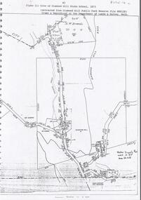
Document - DIAMOND HILL STATE SCHOOL SITE
Map (copy) showing the site of Diamond Hill State School, 1873. On top of page 'extracted from Diamond Hill Public Park Reserve File RS8128, drawn and reproduced at the Department of Lands and Survey, Melbourne'bendigo, education, diamond hill state school -
 Bendigo Historical Society Inc.
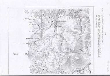
Document - DIAMOND HILL AREA MAP
... BENDIGO Mining diamond hill Map copy, 2 pages, from 'Old Mines ...Map copy, 2 pages, from 'Old Mines Department Plan, Dept of Conservation and Environment File No W91006, 16.6.1972' Map shows Golden Gully area with 'Town and Country Hotel' on north side and further south, with shafts and mine names marked.bendigo, mining, diamond hill -
 Bendigo Historical Society Inc.
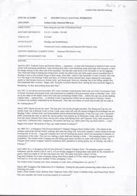
Document - GOLDEN GULLY ALLUVIAL WORKINGS
Golden Gully alluvial workings, Diamond Hill area, site number 1.1. Document has map/grid references, parcel number and location - runs along Woodward Road. History from 1851 to 186 detailed. . Information from David Bannear's Bendigo goldfields survey. -
 Bendigo Historical Society Inc.
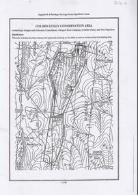
Document - DIAMOND HILL, GOLDEN GULLY COSERVATION AREA
... BENDIGO Mining golden gully Map of Golden Gully conservation area ...Map of Golden Gully conservation area comprising Glasgow and Golconda Consolidated, Glasgow Reef Company (Golden Gully) and New Napoleon. The area is significant because it contains the 'best evidence for hydraulic sluicing on the field as well as several early reef mining sites' On top of page 'Eaglehawk & Bendigo Heritage Study, Significant areas' Mines marked on page: Goldfields Extended shaft South Concord shaft Concord shaft Morning Light shaft Hansel and Mundy shaftbendigo, mining, golden gully -
 Bendigo Historical Society Inc.
Document - VICTORIA HILL - PLAN OF THE VICTORIA REEF GOLD MINES COMPANY BENDIGO
... Inc. History House 11 Mackenzie Street Bendigo goldfields MAP ...3587.70 same as 3587.69. Copied onto smaller white paper.map, bendigo, victoria hill, victoria hill, plan of the victoria reef gold mines company bendigo -
Bendigo Historical Society Inc.
Document - VICTORIA HILL - VICTORIA HILL AREA MAP
... Inc. History House 11 Mackenzie Street Bendigo goldfields MAP ...Photocopied map on cream paper. Map is the Victoria Hill area showing the locations of the Gold Mines Hotel, John Brown Factory and W Rae's Home. Map also shows mine shafts and open cuts.map, bendigo, victoria hill, victoria hill, victoria hill map, gold mines hotel, john brown factory, w rae's home, victoria consols, adventure and advance open cut, great central victoria, rae's open cut, victoria qiartz, ballerstedt's open cut, lansell's '180', north old chum, central nell gwynne -
Bendigo Historical Society Inc.
Book - VICTORIA HILL - VICTORIA HILL BENDIGO
Booklet titled: 'Victoria Hill Bendigo A Publication of the Bendigo Trust'. Booklet has photos of the Central Nell Gwynne Mine, Victoria Hill in the 1860's, with Rae's Battery in the foreground, geographical features, Rae's Open Cut, Victoria Hill from the New Chum Hill in the 1870's, compressor beds, The victoria Quartz Mine, burnt ground from quartz roasting, the remains of a twenty head crushing battery, a view from Ballerstedt's Open Cut showing the historic Gold Mines Hotel built in 1857 and the engine beds of Lansell's '180' mine. There are also two maps, History of Victoria Hill and geographical notes on the area.book, bendigo, victoria hill, victoria hill, victoria hill bendigo -
 Bendigo Historical Society Inc.
Book - EAGLEHAWK STRUCTURE PLAN BACKGROUND REPORTS, 2011
Eaglehawk Structure Plan Background Reports, 5 reports in 2 volumes identifying a broad range of findings to guide future strategis planning in Eaglehawk, with maps photographs and graphs. Prepared for City of Greater Bendigo: Reports 1 & 2 prepared by Centrum Town Planning (5756a) Reports 3, 4 & 5 prepared by Traffic Works (5756b)Centrum Town Planningbendigo, council, eaglehawk structure plan -
 Bendigo Historical Society Inc.
Book - FORTUNA COLLECTION: ARCHAEOLOGICAL ASSESSMENT REPORT 2009, 2009
Fortuna Bendigo Archaeological Assessment Final Report, prepared for the Department of Defence January 2009 by Godden Mackay Logan Heritage Consultants 105 pages with maps, plans & photographs.Godden Mackay Logan Heritage Consultantsbuildings, house, fortuna -
Bendigo Historical Society Inc.
Book - CHINESE DOCTOR JAMES LAMSEY & LADY JANE OF BENDIGO
Chinese Doctor James Lamsey & Lady Jane of Bendigo, 82 pages detailing the life of Doctor Lamsey & family with details of properties owned, black and white photographs & a map. Compiled by Carol Holsworth for the Friends of the Bendigo Cemeteries Inc.Carol Holsworthbendigo, chinese, history -
 Bendigo Historical Society Inc.
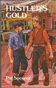
Book - HUSTLER'S GOLD
Hustler's Gold, a childrens' fictional book about 2 youths, best friends, and their escapades all set against the background of Hustlers Reef Bendigo, 126 pages with black and white illustrations by Rachel Tonkin and a map, first published 1969 by Lansdowne Press, hard cover with dustjacket.Pat Spencerbook, bendigo, childrens -
Bendigo Historical Society Inc.
Book - TO BIG HILL AND BACK
To Big Hill and Back 1971. Compiled for the back to celebrations and contains historical information on the area with memories of older residents, 49 pages with black and white photographs, advertisements and a map. Includes indexAlma F Mulqueenbendigo, history, big hill, bendigo, history, big hill, ravenswood -
 Bendigo Historical Society Inc.
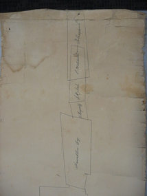
Document - PLAN SHOWING THE VARIOUS CLAIMS ON THE NEW CHUM VICTORIA , ST MUNGO & DEVONSHIRE REEFS BENDIGO
Map of mines - calico scroll showing locations of various claims .printed in black ink on off-white Calico with turned wooden ends on scroll -missing one wooden end , some stains and creasing / Plan showing the various Claims on the New Chum Victoria , St Mungo & Devonshire reefs BendigoW Holmes , printer & lithographer , Sandhurstorganization, mining, industrial, w holmes , printer & lithographer , sandhurst/new cum , victoria st mungo & devonshire reefs bendigo -
 Bendigo Historical Society Inc.
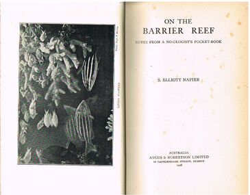
Book - ALEC H CHISHOLM COLLECTION: BOOK ''ON THE BARRIER REEF'' BY S. ELLIOTT NAPIER
Book. ALEC H CHISHOLM COLLECTION. 173 page hardcover book giving an account of a journey along the Great Barrier Reef by S. Elliott Napier. Notes from a No-ologist's Pocket- Book. Includes 36 B & W photographs and 2 maps. Published in 1928 by Angus & Robertson, Sydney and printed by Eagle Press, Waterloo. Catalogue sticker ''2219 NAP'' on spine. Handwritten in ink on flyleaf ''A. H. Chisholm from the author with all good wishes S. Elliott Napier 25-6-28''S. Elliott Napierbooks, collections, australiana, alec h chisholm collection, s.elliott napier, great barrier reef, birds, fish, flora. -
 Bendigo Historical Society Inc.
Document - BADHAM COLLECTION: EXHIBITION LABELS X 15 - CARDBOARDS
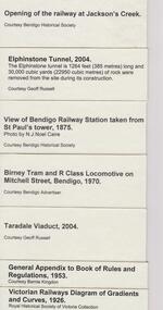
Exhibition labels x 15 - cardboards Railway Post Office stamps, 1865, and book 1951 - Courtesy Edna Westhead. Copy of 1887 Map of Railway Post Offices - Courtesy Edna Westhead Taken in 1921, Bendigo railway men celebrating 50 years since first train arrived in Bendigo in 1862 - Courtesy Bendigo Historical Society Book of Signals, 1949 - Courtesy Bernie Kingdon Book of Instruction Rolling Stock 1921, 1943 - Courtesy Bernie Kingdon Lost Property Book, 1886 - Courtesy Ross Rowley View of Bendigo Railway Station taken from St. Paul's tower, 1875 - Courtesy Bendigo Historical Society...document, memo, railway -
 Bendigo Historical Society Inc.
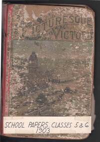
Book - THE SCHOOL PAPER (CLASSES V AND VI) 1902/1903, Nov 1902
Seven copies of the School Paper (Classes V and VI) 1902/1903 issued by the Education Department, Victoria. No 47 Nov 1902; No 49 Feb 1902; No 50 Mar 1903; No 52 May 1903; No 53 June 1903; No 54 July 1903; No 55 Aug 1903/ Each copy comprises 20-30 pages on various topics used as a teaching aid. Illustrated with some B&W photos and maps. Printed by the Government Printer. Three copies are handstitched into the covers of a book called ''Picturesque Victoria Exercise Book'' with its contents removed. Four copies are loose. ''School papers classes 5 & 6'' hand printed on a piece of card and taped to front cover. The name of ''John Steen'' is handwritten in pencil on two of the copies.education, bendigo -
Bendigo Historical Society Inc.
Map - BELLE VUE NO 2 - PLAN OF LEASES
... Inc. History House 11 Mackenzie Street Bendigo goldfields MAP ...Plan of Mining Leases from Rowan Street to Long Gully. Reference J. N. Macartney 2nd Edition Bendigo Goldfields Registry for 1872. Names of Leases are: Moore ?, Ellesmere Co, Bonati & Co, Dennis, Abe Lincoln Co, Lansell & Hunt, Black & White Lead Co, Koch & Hildebrand, Ballerstedt, Lazarus Co No 1, Lazarus Co, Watson, Lazarus Freehold, Lazarus Co No 2, Lazarus Tribute, South Extended Burra, Endeavor Co, Old Chum Co, Burrows and Sterry, New Chum & Victoria Trib, Jackson, North Old Wybrants Chum Co, Myra Co, McLenn, Geary & Co, Western Victoria Hill G. M. Co, Victoria Reef G.M.Co, South Adventure Co, South Try Me Well, W. Rae, Wells Midway, Extended Co, Handy Andy, Moonta Co, Humboldt Co, Adventure Co, Try Me Well, Sterry & Co, Midway, Tudor, Friedman's Reef, Rising Sun, Try Me Luck,Pomponia, Confidence Co, Alfred Co, Advance Co, Prince Alfred Co, Canterbury Co, Platus Co, S. Platus Co, Golden Fleece United, Alfred Co, Iron Duke Co, Victoria Gold Mines Co, Hercules Co and Iron Bark.map, bendigo, mining plan, belle vue no 2, no 2 belle vue new chum & c, j n macartney bendigo goldfields registry 1872, moore ?, ellesmere co, bonati & co, dennis, abe lincoln co, lansell & hunt, black & white lead co, koch & hildebrand, ballerstedt, lazarus co no 1, lazarus co, watson, lazarus freehold, lazarus co no 2, lazarus tribute, south extended burra, endeavor co, old chum co, burrows and sterry, new chum & victoria trib, jackson, north old wybrants chum co, myra co, mclenn, geary & co, western victoria hill g. m. co, victoria reef g.m.co, south adventure co, south try me well, w. rae, wells midway, extended co, handy andy, moonta co, humboldt co, adventure co, try me well, sterry & co, midway, tudor, friedman's reef, rising sun, try me luck, pomponia, confidence co, alfred co, advance co, prince alfred co, canterbury co, platus co, s. platus co, golden fleece united, alfred co, iron duke co, victoria gold mines co, hercules co, iron bark -
 Bendigo Historical Society Inc.
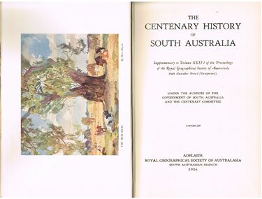
Book - ALEC H CHISHOLM COLLECTION: BOOK ''CENTENARY HISTORY OF SOUTH AUSTRALIA''
Book. ALEC H CHISHOLM COLLECTION. 420 page history of South Australia (1836 - 1936). Illustrated with B & W photos, maps and a colour plate of a painting by Hans Heysen. Published in 1936 by The Royal Geographical Society of Australasia ( South Australian Branch). Printed by the Hassell Press, Adelaide. Chapters written by various contributors. Catalogue sticker ''2165 VAR'' on spine. A typed page stuck on the flyleaf indicates the book belonged to the Education Dept., Adelaide. Handwritten in ink on this typed insert ''Given to me by Adey's successor, Dr. C. Fenner. A H Chisholm''Variousbooks, collections, history, alec h chisholm collection, south australia, centenary, royal geographical society of australasia, history -
 Bendigo Historical Society Inc.
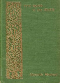
Book - ALEC H CHISHOLM COLLECTION: BOOK 'THE ROAD TO THE ISLES' BY KENNETH MACLEOD
Book. ALEC H CHISHOLM COLLECTION. A 248 page hardcover book of poetry, lore and tradition of the Hebrides. With an introduction by Marjory Kennedy-Fraser. Published in 1933 by Grant & Murray, Edinburgh and printed in Great Britain by Turnbull & Spears. Maps of the Isles inside front and back covers. Catalogue sticker ''2185 MAC'' on spine.Kenneth MacLeodbooks, collections, poetry, alec h chisholm collection, kenneth macleod, poetry, hebrides -
 Bendigo Historical Society Inc.
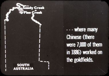
Slide - DIGGERS & MINING. THE CHINESE ON THE GOLD FIELDS, c1850s
Diggers & Mining. The Chinese on the Gold Fields. Slide: Shows map of South Australia, Sandy Creek and Pine Creek are at the top of the map. Slide; reads . . . Where many Chinese (there were 7,000 of them in 1886) worked on the goldfields. Markings: 3. Used as a teaching aid.hanimounteducation, tertiary, goldfields -
 Bendigo Historical Society Inc.
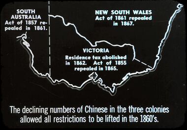
Slide - DIGGERS & MINING. THE CHINESE ON THE GOLD FIELDS, c1850s
Diggers & Mining. The Chinese on the Gold Fields. Slide: Shows map of Victoria and part of South Australia and New South Wales. South Australia Act. Of 1857 repealed I 1861. New South Wales Act. Of 1861 repealed I 1867. Victoria Residence tax abolished in 1862. Act. Of 1855 repealed in 1865. The declining numbers of Chinese in the three colonies allowed all restrictions to be lifted in the 1860's. Markings: 2 2. Used as a teaching aid.hanimounteducation, tertiary, goldfields -
 Bendigo Historical Society Inc.
Document - HARRIS COLLECTION: HAMS SQUATTING MAP OF VICTORIA, PORT PHILLIP DISTRICT, NSW
... Inc. History House 11 Mackenzie Street Bendigo goldfields MAP ...Folding map enclosed in burgundy cover. Map backed by cloth and bound. Rare, early map of Victoria and neighbouring Port Phillip District of New South Wales. Written on bottom RH corner of map: Ham's Squatting Map of Victoria ( Port Phillip District, New South Wales ) carefully corrected to this date from the Colonial Government Surveys, Crown Lands, Commissioners & Explorers Maps, Private Surveys & c. Respectfully inscribed (with permission ) to His Excellency Sir Chas A. Fitz-Roy Knt, Governor of New South Wales &c &c by his Obedient Servant, The Compiler, 1851. Compiled, engraved and published by Thomas Ham, Melbourne. Proposed and original boundary ( in legend) have been coloured in in blue and pink ink ( later addition ?) Number on map show 'reference to proprietor's Printed on back of map ' J.G. AD 1852, with two cross hatched decorations and two hearts entwined. On other back panel in pencil enclosed in a drawn frame ' G.S.H., 1889, Axedale' (George Harris, Axedale, belongs in Harris Collection) Stamped in purple ink 'Royal Historical Society of Victoria, Bendigo Branch. Written 1959, 53.map, victoria, squatting map -
 Bendigo Historical Society Inc.
Map - OLD TOM MINE, WHIPSTICK
2 copies ( A4 and A3) of Old Tom lease. Map shows Old Tom Reef, old working open cutting, shaft 150 ft., Easter Reef, dam sand heap, water race, 3 other shafts, 120ft., 90ft., and 500 ft. marked on map. Stamped on map '64.3.34' Written on bottom of map in handwriting ' Old Tom Lease, Parish of Huntly, County of Bendigo, Mining district of Sandhurst'bendigo, mining, old tom lease map -
 Bendigo Historical Society Inc.
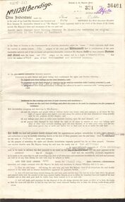
Document - MCCOLL, RANKIN AND STANISTREET COLLECTION: SITE LEASE, 3rd October, 1950
Mining site lease No. 11281. The lease of the site is for Machinery for the South Nell Gwynne Gold Mining Co., includes Map of the site. Dated 2nd September 1950.gold, mining, lease, bendigo, gold mines, mining lease, south nerll gwynne gold mining co. -
 Bendigo Historical Society Inc.
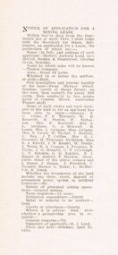
Document - MCCOLL, RANKIN AND STANISTREET COLLECTION: THANET LEASE, 1930's
Manilla folder of documents relating to the application by Herbert Jackson Leed for mining lease No. 10500, called the Thanet Lease. Containing a list of all of the owners of the allotments on the proposed lease and consent forms for them to sign. A map of the lease and of the subdivision of allotments 97 and 92. Various correspondence and application forms.gold, mining, land application, bendigo, gold mining. thanet lease, herbert jackson leed. -
 Bendigo Historical Society Inc.
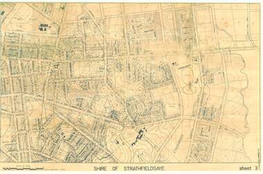
Map - SHIRE OF STRATHFIELDSAYE SHEET 3 PLAN OF PROPERTIES
... Inc. History House 11 Mackenzie Street Bendigo goldfields MAP ...large 97x65cm paper Shire of Strathfieldsaye Sheet 3 Plan of Properties-map, bendigo, shire of strathfieldsaye -
 Bendigo Historical Society Inc.
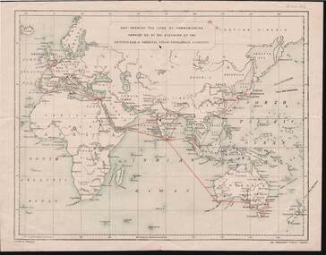
Document - KELLY AND ALLSOP COLLECTION: MAP OF P & O SHIPPING ROUTES
Document. KELLY & ALLSOP COLLECTION. Map of Europe, Africa and Asia showing the shipping routes of the Peninsular & Oriental Steam Navigation Co. Routes highlighted in red. Produced by Nissen & Arnold, Fenchurch St., London. Date estimated as early 20th century.Nissen & Arnoldbusiness, stockbroker, kelly & allsop, kelly & allsop collection, p & o map, shipping routes, nissen & arnold. -
 Bendigo Historical Society Inc.
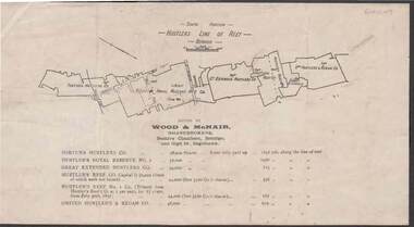
Document - KELLY AND ALLSOP COLLECTION: HUSTLERS LINE OF REEF MAP, 30/07/1891
Document. KELLY & ALLSOP COLLECTION. Map of the Hustlers Line of Reef, Bendigo (South portion). Issued by Wood & McNair, Sharebrokers, Beehive Chambers, Bendigo and High St., Eaglehawk. Mines shown on map are Fortuna Hustler's Co., Hustler's Royal Reserve No.2, Great Extended Hustlers Co., Hustlers Reef Co., Hustler's Reef No.1 Co., United Hustler's & Redan Co. Number of shares is listed against each of these mines.Wood & McNairbusiness, stockbroker, kelly & allsop, kelly & allsop collection, hustlers line of reef map, wood & mcnair. -
 Bendigo Historical Society Inc.
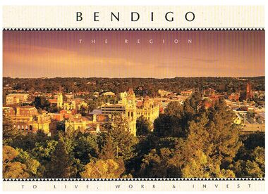
Book - BENDIGO - THE REGION TO LIVE, WORK & INVEST
Pale yellow 12 page book titled 'Bendigo the Region to Live Work & Invest'. On the front cover is a scenic view of Bendigo and on the back cover a picture of some quartz and gold nuggets on a green background. Sections in the book are: Live Work & Invest, Lifestyle, Access, Community, Infrastructure, Labour Force, Business, Opportunity, Successes and Information. Each page has a colour picture, they are:- Hargreaves Mall, Eaglehawk Golf Course, Map of Victoria, La Trobe University, Big Hill, Regional Office Department of Planning & Development, Sandhurst Farms, Construction Activity, Products of the Region, Dr. Ian Macbean, Mr Evan Jones and the Capital Theatre with information on each.book, bendigo, bendigo, bendigo - the region to live, work & invest, bendigo regional development board, dr ian macbean, mr evan jones, kate mildren, richard gibbs, express printers, hargreaves mall, eaglehawk golf course, map of victoria, la trobe university, big hill, regional office department of planning & development, sandhurst farms, construction activity, products of the region, capital theatre