Showing 23185 items matching "creek"
-
 Eltham District Historical Society Inc
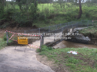
Photograph - Digital Photograph, Carlota Quinlan, Diamond Creek in flood, Diamond Creek Trail, Eltham South, 17 Oct 2021
diamond creek (creek), diamond creek trail, eltham south, flooding, floods, floodwater -
 Eltham District Historical Society Inc
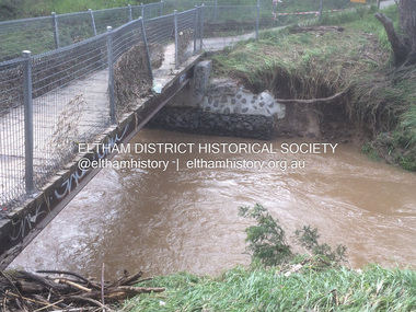
Photograph - Digital Photograph, Carlota Quinlan, Diamond Creek in flood, Diamond Creek Trail, Eltham South, 17 Oct 2021
diamond creek (creek), diamond creek trail, eltham south, flooding, floods, floodwater -
 Eltham District Historical Society Inc
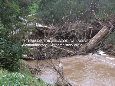
Photograph - Digital Photograph, Carlota Quinlan, Diamond Creek in flood, Diamond Creek Trail, Eltham South, 17 Oct 2021
diamond creek (creek), diamond creek trail, eltham south, flooding, floods, floodwater -
 Eltham District Historical Society Inc
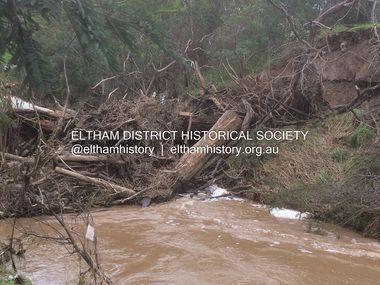
Photograph - Digital Photograph, Carlota Quinlan, Diamond Creek in flood, Diamond Creek Trail, Eltham South, 17 Oct 2021
diamond creek (creek), diamond creek trail, eltham south, flooding, floods, floodwater -
 Eltham District Historical Society Inc
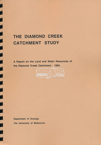
Book, Department of Zoology, The University of Melbourne, The Diamond Creek Catchment Study: A report on the Land and Water Resources of the Diamond Creek Catchment, 1994
Shire of Nillumbik -
 Eltham District Historical Society Inc
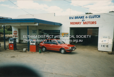
Photograph, Graeme Hardiman, D.V. Brake & Clutch & Midway Motors, 274 Diamond Creek Rd, Diamond Creek, n.d
Now a BP Service Station opposite McLaughlans Lane, Plentyd.v. brake & clutch & midway motors, diamond creek, diamond creek rd -
 Eltham District Historical Society Inc
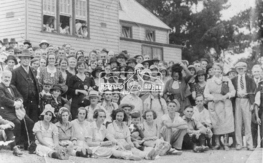
Photograph, Gathering at Upper Diamond Creek State School No. 2059, corner of Yates and Heidelberg Kinglake Roads, Upper Diamond Creek
Black and white copy of photo printed on glossy photographic paper 30.5 x 40.5 cm (12 x 16 inch); image size approx. 18.5 x 28 cmgroups, upper diamond creek state school -
 Eltham District Historical Society Inc
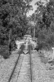
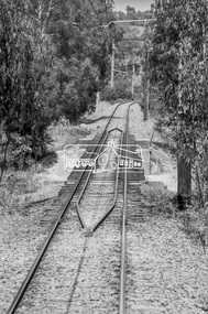
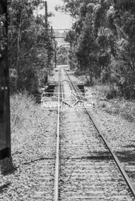
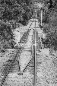
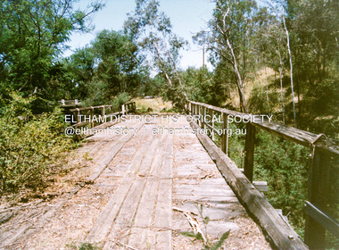
Photograph, George Coop, Derailment guard rails on the Hurstbridge line as the track crosses the Diamond Creek just north of Allendale Road, Diamond Creek, 6 December 1980, 1980
The device pictured is intended to prevent severe derailment and to keep errant trains in line with track when going over culverts or similar should they become derailedDigital TIFF file Scan of 35mm Ilford FP4 black and white transparencyallendale road, derailment guard rail, diamond creek, railway bridge -
 Eltham District Historical Society Inc
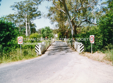
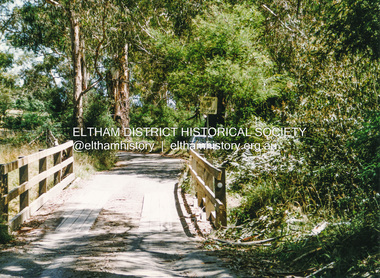
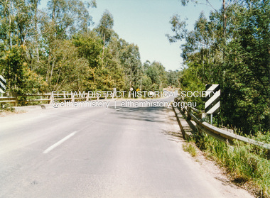
Photograph, Doug Orford, Monash Bridge across Diamond Creek, Hurstbridge - Arthurs Creek Road, Hurstbridge, 1991, 1991
From a collection of 35 photos taken by Doug Orford at 35 specific locations along the exact boundary of the then Shire of Eltham.Colour photographbridges, diamond creek, hurstbridge - arthurs creek road, hurstbridge, monash bridge -
 Eltham District Historical Society Inc
Photograph, Doug Orford, Burkes Bridge across Arthurs Creek, Hurstbridge - Arthurs Creek Road, Hurstbridge, 1991, 1991
From a collection of 35 photos taken by Doug Orford at 35 specific locations along the exact boundary of the then Shire of Eltham.Colour photographbridges, hurstbridge - arthurs creek road, hurstbridge, burkes bridge, arthurs creek -
 Eltham District Historical Society Inc
Photograph, Doug Orford, The old Burkes Bridge across Arthurs Creek, Hurstbridge - Arthurs Creek Road, Hurstbridge, 1991, 1991
From a collection of 35 photos taken by Doug Orford at 35 specific locations along the exact boundary of the then Shire of Eltham.Colour photographbridges, hurstbridge - arthurs creek road, hurstbridge, burkes bridge, arthurs creek -
 Eltham District Historical Society Inc
Photograph, Doug Orford, Bridge across Arthurs Creek, Eagles Nest Road, Arthurs Creek, 1991, 1991
From a collection of 35 photos taken by Doug Orford at 35 specific locations along the exact boundary of the then Shire of Eltham.Colour photographbridges, arthurs creek, eagles nest road -
 Eltham District Historical Society Inc
Photograph, Doug Orford, Bridge across Watsons Creek, Eltham - Yarra Glen Road, Watsons Creek, 1991, 1991
From a collection of 35 photos taken by Doug Orford at 35 specific locations along the exact boundary of the then Shire of Eltham.Colour photographwatsons creek, bridges, eltham - yarra glen road -
 Inverloch Historical Society
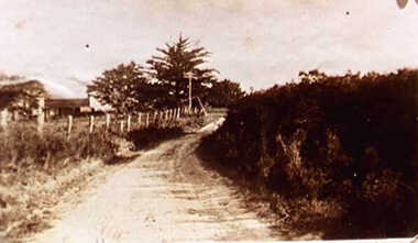
000214 - Photogragh - 1936 - Pound Creek - Road to the Pound Creek Post Office from the school - Closed when home was demolished after end of war II - D Beard
-
 Inverloch Historical Society
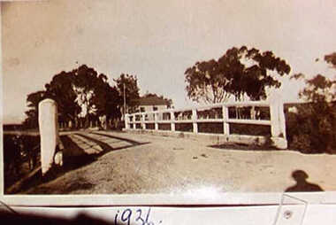
000215 - Photogragh - 1936 - Pound Creek - Pound Creek Bridge - D Beard
-
 Stawell Historical Society Inc
Archive - CD/DVD, Scans of Ararat and Pleasant Creek Papers 1857-1869. Scanned from Microfisch. The Ararat &Pleasant Creek Advertiser 1861-1869, The Mount AraratAdvertiser 1857-1861
stawell -
![Photograph (sub-item) - Black and White, The Wonga Park ‘swimming pool’ in the Yarra River, 1940’s – now in Jumping Creek Reserve (1985) [This may be the swimming pool in Jumping Creek Reserve or may be the swimming pool in Clifford Park in use in the 1948-9 Pan-Pacific Jamboree]](/media/collectors/5c7716e021ea6a1a60039fee/items/631b95b3d61f455ba20ef2cb/item-media/631b961fd61f455ba20ef417/item-fit-380x285.jpg) Wonga Park Community Cottage History Group
Wonga Park Community Cottage History GroupPhotograph (sub-item) - Black and White, The Wonga Park ‘swimming pool’ in the Yarra River, 1940’s – now in Jumping Creek Reserve (1985) [This may be the swimming pool in Jumping Creek Reserve or may be the swimming pool in Clifford Park in use in the 1948-9 Pan-Pacific Jamboree]
THE ROSE SERIES P. 922 SWIMMING POOL, RIVER YARRA, WONGA PARK, VIC. -
 Eltham District Historical Society Inc
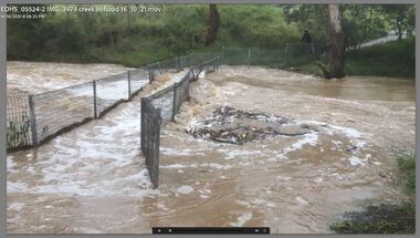
Film - Video (Digital), Carlota Quinlan, Diamond Creek in flood, Diamond Creek Trail, Eltham South, 16 Oct 2021
diamond creek (creek), diamond creek trail, eltham south, flooding, floods, floodwater -
 Falls Creek Historical Society
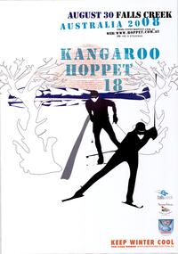
Poster - Kangaroo Hoppet 2008
The Kangaroo Hoppet is Australia’s premier long distance cross country ski race, and a member of the Worldloppet series of international cross country ski events. The first race at Falls Creek was held in 1979 under the name of “Australian Birkebeiner”. It was a 21km race with about 80 participants organised by the Birkebeiner Nordic Ski Club of Mount Beauty. The course started and finished at Falls Creek Alpine Resort and took participants out into the Bogong High Plains. After running the event for 10 years, it was decided they should become part of the Worldloppet series of marathon ski races. Representatives from the Birkebeiner Nordic Ski Club and the Australian Ski Federation attended the Worldloppet Annual Meeting in Finland in June 1990 to put the case for the acceptance of an Australian event into the Worldloppet series. Before being admitted, they had to demonstrate that the Birkebeiner Club could run a world class event, so three months later in August 1990 a 42km event named the Australian International Ski Marathon was held at Falls Creek together with a 21km Birkebeiner race and a 7km event called the Birkebeiner Lite. The event was approved by delegates from USA, Norway and Austria, in 1991 Australia became the 12th member of Worldloppet, with the condition that there had to be a name change. After some late night discussion allegedly involving red wine from North East Victoria the main event became the 42km Kangaroo Hoppet, with the minor events being the 21km Australian Birkebeiner, and 7km Joey Hoppet. In the winter of 1991, the first Kangaroo Hoppet was held. It was a great success and has been a regular fixture on the international ski calendar ever since. It features the main 42km event as well as a 21km event and a 7km event. The Hoppet brings the Australian snowfields to an international audience. In 2008 the Men's Winner was Ben Sim from Australia in a time of 1:42:16. The winner of the Women's event was Evelyn Dong of USA in a time of 2:00:35. This poster is significant because it documents an event which brings international attention to Falls Creek and the surrounding region.A poster with an image of two stylised skiers in black moving between trees towards the audience. The red sun in the background is composed by repetition of horizontal red lines of the words "KANGAROO HOPPET 18 AUGUST 30 FALLS CREEK AUSTRALIA." The logos of Falls Creek, Tourism Victoria and Worldloppet are on the bottom right hand side. text is in blue and black.At the top: AUGUST 30 FALLS CREEK AUSTRALIA 2008 KANGAROO HOPPET 18 Email: [email protected] WEB: www.hoppet.com.au PH: +61 3 57541045kangaroo hoppet, worldloppet events, falls creek, mt. beauty -
 Eltham District Historical Society Inc
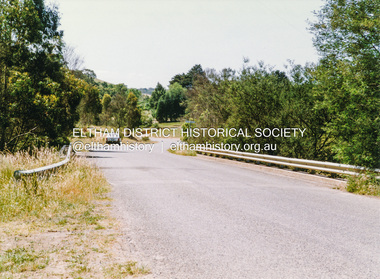
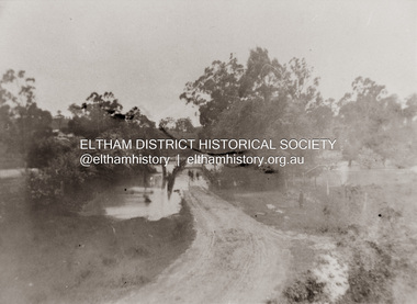
Photograph, Diamond Creek in flood over Glen Park Bridge, Eltham, c. 26 August 1924
Significant flooding of the Diamond Creek occurred in Eltham and Glen Park on Tuesday, August 26, 1924 with several houses swamped and all bridges covered except the Greensborough Road Bridge. [Houses at Eltham Flooded. (1924, August 27). The Argus (Melbourne, Vic. : 1848 - 1957), p. 19. Retrieved from http://nla.gov.au/nla.news-article4156891] The Glen Park Bridge was originally built as a replacement for an older private bridge built by a man named Foley around 1880. In 1911 Heidelberg and Eltham agreed to share the costs to build a new bridge. Construction began in June 1915 and it was officially opened by Cr. Taylor on Cup Day, November 1915. The bridge was destroyed by floodwaters in the afternoon of 20 September 1959 during construction of the new Wattletree Road bridge. The new bridge west embankment joined the existing road at approximately where the bend in the road is situated in the photograph.Colour photograph of originalfloods, eltham, diamond creek (creek), egan's crossing, eltham-diamond creek road, glen park bridge, glen park road -
 Falls Creek Historical Society
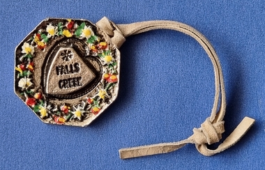
Decorative object - Medallion - Falls Creek and Ullr, Patron Saint of Skiers
This medallion was donated by Hayley Martin. Throughout the 1960s and early 1970s the six members of the Martin Family generally spent at least a week each year at Falls Creek, staying at Spargo's Lodge. The Martins then bought a share in Diana Lodge and stayed there frequently until the late 1970s. Medallions such as this one purchased at Cuming's Ski Hire, were commonly worn by skiers attached to an item of their ski apparel with the leather strap. The reverse side features an image from Nordic mythology. Ullr was the God of Snow, Patron Saint of Skiers, the son of Sif and stepson of Thor, the God of Thunder. Ullr was said to be an expert skater, skier and hunter who would glide around the world and cover the land with snow. Skiers hoped Ullr would ensure them of a good snow season and also protect them from injury.This item is significant because variations of medallions such as this were worn by many skiers and also advertised Falls Creek.A metal medallion decorated with wildflowers on one side and the image of Ullr, Patron Saint of Skiers on the reverse side.ullr patron saint of skiers, cuming's ski hire, spargo lodge, diana alpine lodge -
 Falls Creek Historical Society
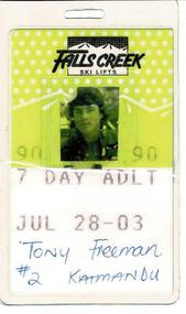
Ski Lift Passes 1990
SKI TICKETS Before tows and lifts were introduced at Falls Creek, it could take skiers 20 minutes to climb to the Summit … but only TWO minutes to go back to the bottom. The arrival of tows, then chairlifts and T-bars changed the face of skiing forever. The first rope tow was constructed by Toni St. Elmo for the 1951 winter season. Bob Hymans installed a smaller tow for his guests at Skyline Lodge. Tows were still quite slow, so in 1956 Bob Hymans created his single chairlift. In 1958 the Village rope tow, designed by Albury engineer Jock Wilson, opened. It was financed by shareholders including Bill Griffith (Bowna Ski Club) and the Bridgford family (St. Trinian’s Ski Club). Several other tows followed including the Summit T-bar in 1961, built by Ron McCallum and operated by Alpine Developments Pty. Ltd. which was a company formed by C. H. (Bill) Bridgford. By 1982 Falls Creek was served by 16 different lifts or T-bars, all owned and operated by Alpine Developments (Holdings) Pty. Ltd. During the development of Falls Creek, different methods have been used to pay for the use of tows, lifts and T-bars … including metal tokens, single tickets, strips of tickets and season passes. The Falls Creek Historical Society Collection includes many examples of these items.These tickets are significant because they represent a stage in the progression of chair lifts and management at Falls Creek Tourist Village.A selection of unused Falls Creek Ski Lift passes and one 7 Day Adult Pass issued to Tony Freeman # s Kathmandu. Different coloured tickets were for a different length of visit. A 7 Day Adult pass cost $234.On completed pass FALLS CREEK SKI LIFTS 90 7 DAY ADULT JUL 28 - 03 TONY FREEMAN #2 KATHMANDUchairlift falls creek, falls creek passes -
 Southern Sherbrooke Historical Society Inc.
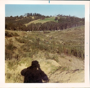
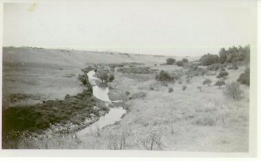
Photograph - Cardinia Creek area, Narre Warren East, prior to dam works
A set of four colour photos showing the area around where Cardinia Reservoir is now located. The photos show various views of the hillsides and valleys prior to the damming of Cardinia Creek. Each photo has 'Belgrave Cardinia Creek' handwritten on the back. They date from prior to May 1970. The set was donated to the society by David Howe. 'Belgrave Cardinia Creek' handwritten on the back of each photo. -
 Lakes Entrance Historical Society
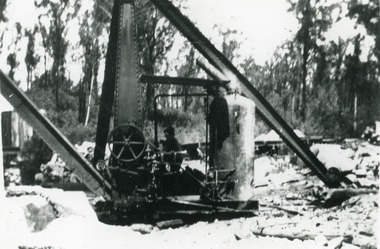
Photograph - Mississippi Creek Landing, 1930c
Black and white photograph of the steam crane used to unload rock from the tramway which brought rock from the Colquhoun quarry to the Mississippi Creek landing, placing the rock into barges for transport to the entrance at Lakes Entrance, Victoria.Steam Crane Mississippi Creek transport, historic site -
Glenelg Shire Council Cultural Collection
Photograph - Photograph - View of Merino Creek bridge, c. 1963
Sourced from Casterton Town Hall (Former Shire of Glenelg)Black and white photo. View of Merino Creek bridgeBack: Black stamp 06 8755 'Merino Creek Bridge' - handwritten in pencil 'Merino Creek Bridge' - handwritten in blue biro Blue biro line, arrowed each end, drawn across width of photo. 7" in blue biro writte above line -
 Clunes Museum
Photograph
VIEW OF CREEK AT CLUNESVIEW OF CREEK AT CLUNESlocal history, photography, photographs, clunes, landscape -
 Sunbury Family History and Heritage Society Inc.
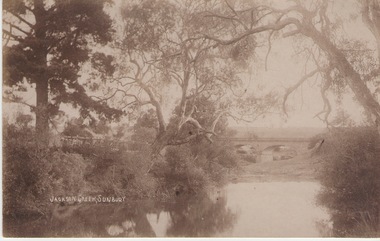
Photograph
The Jacksons Creek and the Macedon Street stone arched bridge are the features in this postcard with a view of a vineyard on the LH river bank. The wine industry was one of the early industries caroused out in Sunbury by the early European settlers in the district.A sepia photograph in post card format of a waterway with overhanging trees and an arched bridge in the middl;e distance.JACKSONS CREEK, SUNBURYjacksons creek, macedon street bridge, vineyards.