Showing 3628 items
matching landscape
-
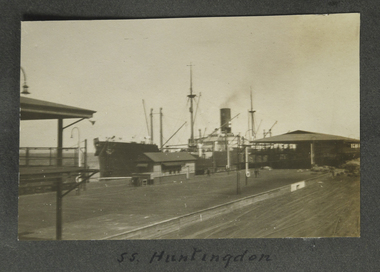 Mission to Seafarers Victoria
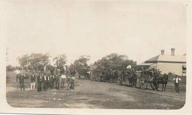
Photograph - Photograph, Sepia, SS Huntingdon, 1928
Possibly Station pier Port Melbournesmall b&w landscape photograph featuring a steamship moored at a railway pier, rail siding in foreground and shedding between rails and vessel. The smoke stack is faintly steaming.Handwritten in black ink on album page beneath image: SS Huntingdonss huntingdon, fan album -
 Glen Eira Historical Society
Album - Album page, Nithsdale now Five Way Hill, Kambrook Road, Circa 1972
This photograph is part of the Caulfield Historical Album 1972. This album was created in approximately 1972 as part of a project by the Caulfield Historical Society to assist in identifying buildings worthy of preservation. The album is related to a Survey the Caulfield Historical Society developed in collaboration with the National Trust of Australia (Victoria) and Caulfield City Council to identify historic buildings within the City of Caulfield that warranted the protection of a National Trust Classification. Principal photographer thought to be Trevor Hart, member of Caulfield Historical Society. Most photographs were taken between 1966-1972 with a small number of photographs being older and from unknown sources. All photographs are black and white except where stated, with 386 photographs over 198 pages. Glen Eira Heritage Management Plan (1996) by Andrew Ward and Associates - Vol 3 "Nithsdale", built for J.S. Crouchin 1858 and extended in 1885 with a tower and associated rooms, survives as testimony to the nineteenth century occupation of the vicinity of the Kambrook/Glen Eira Road intersection. Caulfield's Building Heritage by Dr Geulah Solomon, Vol 1 p49 records it as a small Victorian mansion home on bluestone foundations of Italianate style with a tower. Built for J S Chambers circa 1860, it was built in stages and then the land subdivided in the 1920s. Other owners include Adolph F Brockhoff (of Brockhoff Biscuits company). Names used besides Nithsdale have been Bundoora and Five Way Hill. Page 102 of Photograph Album with four photographs (three landscape and one portrait) of Nithsdale, now known as Five Way Hill. Three views of the tower and one of the house.Handwritten: "Nithsdale" now "Five Way Hill" Kambrook road [top right] / CNR KAMBROOK AND GLENEIRA ROADS [under bottom right photo] / 102 [bottom right]trevor hart, north caulfield, victorian, mid victorian, late victorian, tower, j.s. crouchin, 1850's, 1880's, italianate, rendered, five way hill, nithsdale, slate roof, plaster arches, ornamental columns, triangular pediment, ornamental parapet, cast iron balconies, kambrook road, glen eira road, t crouch, j s crouchin, mansions, j s chambers, bluestone foundations, land subdivision, adolph f brockhoff, bundoora, house names -
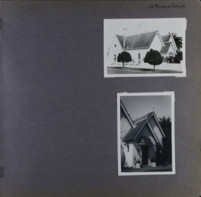 Glen Eira Historical Society
Album - Album page, Avoca Grove, 12, Circa 1972
This photograph is part of the Caulfield Historical Album 1972. This album was created in approximately 1972 as part of a project by the Caulfield Historical Society to assist in identifying buildings worthy of preservation. The album is related to a Survey the Caulfield Historical Society developed in collaboration with the National Trust of Australia (Victoria) and Caulfield City Council to identify historic buildings within the City of Caulfield that warranted the protection of a National Trust Classification. Principal photographer thought to be Trevor Hart, member of Caulfield Historical Society. Most photographs were taken between 1966-1972 with a small number of photographs being older and from unknown sources. All photographs are black and white except where stated, with 386 photographs over 198 pages.From Glen Eira Heritage Management Plan (1996) by Andrew Ward and Associates: The house at 12 Avoca Grove, part of "Merton", now demolished, is understood to have been built for and occupied by James Wilberforce Stephens from c.1865. It has aesthetic and historical significance. The building's aesthetic value is derived from the manner in which it demonstrates aspects of the Cottage Orne style, popular among Melboume's gentry during the mid Victorian period. Its historical value is derived from its association with J. W. Stephens, MLA, for East St Kilda and a prominent Caulfield resident.Page 20 of Photograph Album - two black and white exterior photographs of a house with both photographs on the right hand side of the page, the top in landscape mode and the bottom portrait. Hand written: 12 Avoca Grove [top right of page] / 20 [bottom right]trevor hart, avoca grove, church, caulfield north, merton, james wilberforce stephens, cottage orne style, j w stephens (mla) -
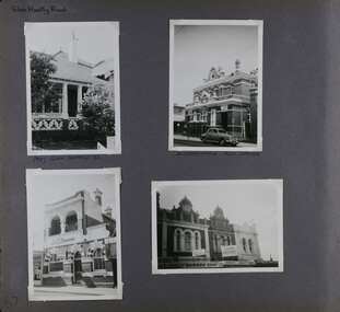 Glen Eira Historical Society
Album - Album page, Glen Huntly Road, Circa 1972
This photograph is part of the Caulfield Historical Album 1972. This album was created in approximately 1972 as part of a project by the Caulfield Historical Society to assist in identifying buildings worthy of preservation. The album is related to a Survey the Caulfield Historical Society developed in collaboration with the National Trust of Australia (Victoria) and Caulfield City Council to identify historic buildings within the City of Caulfield that warranted the protection of a National Trust Classification. Principal photographer thought to be Trevor Hart, member of Caulfield Historical Society. Most photographs were taken between 1966-1972 with a small number of photographs being older and from unknown sources. All photographs are black and white except where stated, with 386 photographs over 198 pages. The Former Elsternwick Post Office is on the Victorian Heritage Register H0640 with a full significance statement and also HO29 with the City of Glen Eira. Much of the Glen Huntly Road heritage retail strip is heritage listed in HO72 with the City of Glen Eira.Page 67 of Photograph Album with four photographs (three portrait and one landscape) of different properties on Glen Huntly Road - a house, Post Office, ANZ Bank and shops.Hand written: Glen Huntly Road [top left] / 1027 GLEN HUNTLY RD [under top left photo] / ELSTERNWICK POST OFFICE [under top right photo] / 67 [bottom left] trevor hart, glen huntly road, elsternwick, shops, caulfield, post offices, glenhuntly road, banks, brick houses, shopping centres -
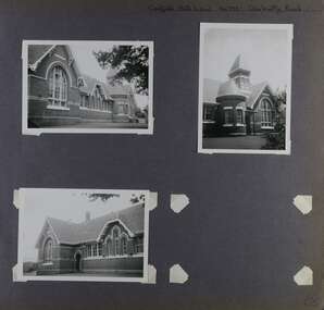 Glen Eira Historical Society
Album - Album page, Caulfield State School, No 773, Glen Huntly Road, Circa 1972
This photograph is part of the Caulfield Historical Album 1972. This album was created in approximately 1972 as part of a project by the Caulfield Historical Society to assist in identifying buildings worthy of preservation. The album is related to a Survey the Caulfield Historical Society developed in collaboration with the National Trust of Australia (Victoria) and Caulfield City Council to identify historic buildings within the City of Caulfield that warranted the protection of a National Trust Classification. Principal photographer thought to be Trevor Hart, member of Caulfield Historical Society. Most photographs were taken between 1966-1972 with a small number of photographs being older and from unknown sources. All photographs are black and white except where stated, with 386 photographs over 198 pages.From: Glen Eira Heritage Management Plan (1996) by Andrew Ward and Associates Caulfield State School No. 773 is important at the State level as the first of similar designs for small schools prepared by the Education Department under H.R. Bastow at Little Bendigo (1878), Glen Waverley (1880), Ascot (1882), Sandringham (1885) and Carlsrich (1892)·. It is a representative example of the Department's Gothic Revival designs, distinguished, however, by the semicircular treatment of the master's office, which compares with Portland (1879), Queensberry St Carlton (1880) and Footscray (1881). It has local significance as the earliest surviving Government School in Caulfield and as a centre for education from 1877, comparing with St. Mary's Jubilee School (qv) of 1887. The Caulfield State School of 1877, the horse tramway of 1889 and subsequently the electric trams were all events confirming the importance of Glenhuntly Road and the fledgling community of "Camden Town" wherein the City's commercial centre has its origins.Page 68 of Photograph Album with three exterior photographs (two portrait and one landscape) of one side of Caulfield State School with a fourth photo missing from the page.Hand written: Caulfield State School No. 773 Glenhuntly Road [top right] / 68 [bottom right] trevor hart, glen huntly road, caulfield state school, caulfield primary school, gothic revival, schools, caulfield south, arched window, tower, 1870's, camden town, red brick, curved windows, terracotta tiles, master's office, education, primary school, glenhuntly road, h r bastow -
 Bendigo Historical Society Inc.
Slide - BCAE - Landscaping, about 1986
Bendigo TAFE is a regional provider of vocational education, training and assessment services, located in northern and central Victoria, Australia. The institute has been in operation in various guises since 1854. The institute was known as the Loddon Campaspe Institute of TAFE from 1987 to 1990, Bendigo Regional Institute of TAFE (BRIT) from 1990 to 2009, before becoming Bendigo TAFE in 2009. Bendigo TAFE services a significant geographical area of approximately 25,000 square kilometres in central and northern Victoria, with a local population of 220,000. In May 2014, Bendigo TAFE announced that it would merge with the Melbourne-based Kangan Institute to form Bendigo Kangan Institute, however both institutes retain their existing branding.Bendigo College of Advanced Education (BCAE) early years - 24 slides of Landscaping at the new premises in Nolan Street Bendigo (Now the Bendigo Tertiary and Further Education (TAFE). history, bendigo, bendigo college of advanced education, bcae, landscaping, bendigo tafe -
 Bendigo Historical Society Inc.
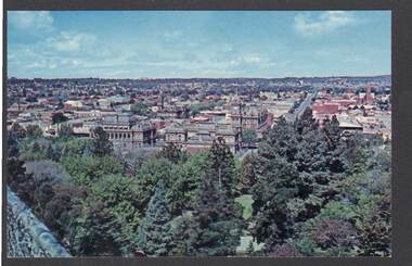
Postcard - PANORAMA FROM ROSALIND PARK LOOKOUT TOWER
Colour postcard, showing landscape view of Bendigo taken from lookout tower in Rosalind Park. Trees in foreground, looking eastward, Shamrock Hotel, city block in foreground.Nu-Color-Vuebendigo, parks and gardens, lookout tower view, bendigo, rosalind park -
 Bendigo Historical Society Inc.
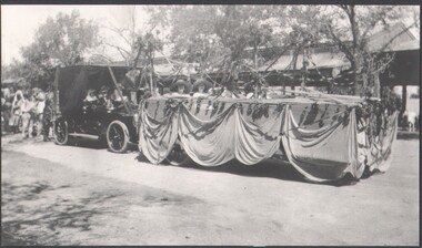
Photograph - B&W photograph of a "float" for the Myer Store for the Bendigo Easter Fair
Early 1900s streetscape of major intersection in BendigoLandscape format. B&W photograph of a "float" for the Myer Store entered in the Bendigo Easter Fair, undated early 1900s photograph. Four people representing Myer on the floatsocial history -
 Bendigo Historical Society Inc.
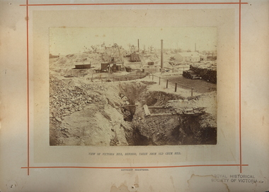
Photograph - VIEWS OF VICTORIA NO 13
Views of Victoria No 13. View of Victoria Hill Bendigo taken from Old Chum Hill. North Old Chum, New Chum and Victoria Companies. Mining landscape -
 Bendigo Historical Society Inc.
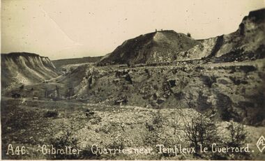
Postcard - ACC LOCK COLLECTION: 'GIBRALTER' QUARRIES NEARTEMPLEUX LE GUERRARD, POSTCARD, 1914-1918
Postcard, WW1, B&W image of the 'Gibralter' quarries near Templeux le Guerrard.Sparse rocky landscape with a lone figure on top of a hillock in background. One copy A46postcard, postcard, ww1, gibralter, quarry, templeux le guerrard, france -
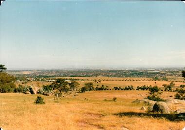 Hume City Civic Collection
Photograph, early 1980s
The Tullamarine Airport opened in 1970 and replaced Essendon Airport as Melbourne's main airport terminal. Gellibrand Hill was incorporated with Woodlands Park and became a public reserve during the 1980s.A coloured landscape photograph with rounded corners taken from Gellibrand Hill and overlooking the Tullamarine Airport which is on the RHS of the photograph. The Melbourne City skyline can be seen in the distance.gellibrand hill, tullamarine airport, melbourne skyline, george evans collection -
Clunes Museum
Souvenir - SOUVENIR FOLDER, JOIN US ON A TRIP AROUND CLUNES
5 X COPIES SOUVENIR - CREAM COLOURED FOLDER WITH DARK TITLE PRINTED ON FRONT CONTAINING 7 X BLACK & WHITE IMAGES OF CLUNES LANDSCAPE PANORAMA AND BUILDINGSlocal history, document, souvenir postcards, souvenir folder, buildings -
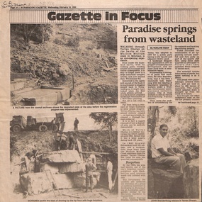 Whitehorse Historical Society Inc.
Newspaper - Article, Paradise springs from wasteland, 14/02/1990
A landscape designer was appointed in 1993 to prepare a master plan after which the mammoth task of clearing and planting was undertaken and koalas and sugar-gliders introduced. Information Centre built.parks and reserves, brandenburg, john p, yarran dheran, mullum mullum creek, smith, dorothy g., koalas, sugar gliders, schwerkolt, johann august -
 Bendigo Historical Society Inc.
Slide - Bendigo College of Advanced Education - Landscaping, about 1986
Bendigo TAFE is a regional provider of vocational education, training and assessment services, located in northern and central Victoria, Australia. The institute has been in operation in various guises since 1854. The institute was known as the Loddon Campaspe Institute of TAFE from 1987 to 1990, Bendigo Regional Institute of TAFE (BRIT) from 1990 to 2009, before becoming Bendigo TAFE in 2009. Bendigo TAFE services a significant geographical area of approximately 25,000 square kilometres in central and northern Victoria, with a local population of 220,000. In May 2014, Bendigo TAFE announced that it would merge with the Melbourne-based Kangan Institute to form Bendigo Kangan Institute, however both institutes retain their existing branding.Bendigo College of Advanced Education (BCAE) early years - 24 slides of Landscaping at the new premises in Nolan Street Bendigo (Now the Bendigo Tertiary and Further Education (TAFE). history, bendigo, bendigo college of advanced education, bcae, landscaping, bendigo tafe -
University of Melbourne, Burnley Campus Archives
Document - Student Work, Shiva Malekzadeh, Construction Assignment 2
student work, assignment, landscape design, construction -
University of Melbourne, Burnley Campus Archives
Photograph - Black and white print, 928/7, 20 October 1947
"20/10/47. Eucalyptus camaldulensis standing in Richmond Park forms part of the landscape of Burnley gardens. Viewed from Oak Lawn." THK See B10.0030(208)eucalyptus, richmond park, burnley gardens, oak lawn, e. m. gibson collection -
University of Melbourne, Burnley Campus Archives
Plan, 'Burnley Park', 1987
Tracing paper copy dated July 1987. Landscape Graphics - Assignment One, 'Burnley Park' Site Plan. Scale 1:100. Includes contours and existing trees.burnley park, trees, landscape graphics -
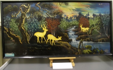 St Vincent's Hospital Melbourne Archives
Artwork, other - Painting, Circa 1966-1967
This painting was presented to the St Vincent's civilian medical team by the people of An Giang Province, Vietnam, in recognition of their work in the area. St Vincent's sent four civilian clinical teams to Long Xuyen, South Vietnam, 1965 - 1966 as part of an aid program administered by the Australian Department of External Affairs to assist Vietnamese medical and paramedical personnel and provide medical aid to everyone who needed it. The service of the Australian civilian teams who went to Vietnam 1964 - 1972 was recognised with a special plaque within the grounds of the Australian War Memorial in October 2008. This item has historical significance because it is a memento of the hospital's involvement in a nationally significant wartime aid program to South Vietnam. Landscape painting of deer near a forest stream. Painted in the traditional Vietnamese style using lacquer and paint. Artwork is framed in a black frame but is not behind glass. The artist is unknown.Plaque is attached at lower left corner and translated reads: The people of An Giang Province / are extremely grateful to the Australian Surgical Team.st vincent's hospital melbourne, paintings, artworks, south vietnam, medical aid -
 Bendigo Military Museum
Programme - BATTALION TRAINING PROGRAMME, C.1937
Forecast program outlining the training for 38th Battalion for a period in March 1937. Items in the collection re Lt Col J Swatton, refer Cat No. 6719.2P for his service history.Loose leaf folder with outline of 38 Battalion camp training programme. Some pages white and some pages pink. Three gold studs at top of page (landscape).Titles "38 Bn Camp Training" - Outline Programme.passchendaele barracks trust, training pprogramme, 38th bn -
 University of Melbourne, Burnley Campus Archives
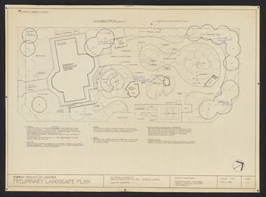
Plan, Steve Mullany, Energy Education Centre, 1988
(1) Tracing paper and paper plans, Preliminary Landscape Plan by Steve Mullany, Lecturer Amenity Horticulture Dept. V.C.A.H. Burnley, Sheet 1 of 1 May 2, 1988. (2) 1 tracing paper and 2 paper copies State Schools' Nursery: Proposed Landscape Working Drawing Energy Education Centre Burnley by E.A.H. June 1988. (3) 2 copies State Schools' Nursery: Proposed Landscape Working Drawing Energy Education Centre Burnley, by EAH 18 June 1988 (Details). (4) 2 copies as (3) Pond Plans & Details 16 June 1988. (5.) Designs for small plans of above.vcah, steve mullany -
 Eltham District Historical Society Inc
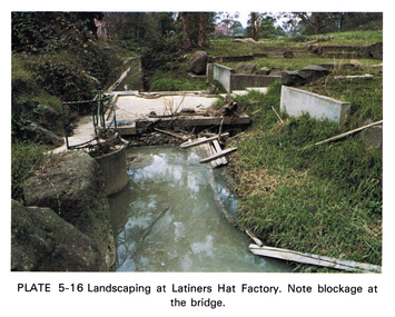
Work on paper (Sub-Item) - Photograph, Landscaping at Latiners Hat Factory
Colour photograph of Landscaping at Latiners Hat Factory, Sherbourne Road, Eltham. Note blockage at the bridgeeltham, drain, latiners, hat factory, landscaping, footbridge, blockage -
 Phillip Island and District Historical Society Inc.
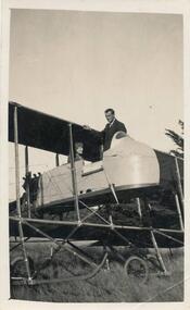
Photograph, Bi-plane on Phillip Island
From Jessie Smith's collection of Island Events & Landscapes. 1st plane to land at Phillip Island.Pilot sitting in Bi-plane. Man in suit welcoming.local history, photographs, transport, aviation, aircraft, phillip island, black & white photograph, jessie smith collection, stan mcfee -
 Phillip Island and District Historical Society Inc.
Photograph, Wood Day for Warley Hospital
From Jessie Smith's collection of local events and landscapes. Community activity to supply community facility.Horse & Drays in right background. Group of men in left foreground. Wood day at Warley Hospital.local history, photographs, buildings, historic, warley hospital, black & white photograph, jessie smith collection, stan mcfee -
Clunes Museum
Book, NATIONAL LIBRARY OF AUSTRALIA et al, CLUNES - A TOWNSCAPE STUDY OF A VICTORIAN COUNTRY TOWN
GENERALLY THIS SIDY IS AN ANALYSIS OF THE VISUAL FABRIC OF THE TOWN AND GIVES SUGGESTED GUIDELINES FOR FUTURE GROWTHBOOK - CLUNES - A TOWNSCAPE STUDY OF A VICTORIAN COUNTRY TOWN PRODUCED BY CENTRE FOR ENVIROMENTAL STUDIES. UNIVERSITY OF MELBOURNE 1977GENERALLY THIS SIDY IS AN ANALYSIS OF THE VISUAL FABRIC OF THE TOWN AND GIVES SUGGESTED GUIDELINES FOR FUTURE GROWTHlocal history, town scape -
 Stawell Historical Society Inc
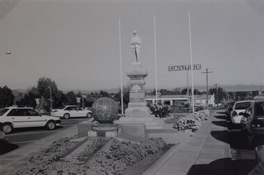
Photograph, Soldiers’ Memorial World War 1 & World War 2 in Main Street
Soldiers’ Memorial and WW2 memorial. This photo shows the memorials in the surrounding landscape at the time, c.1999. Black & White photo showing both Memorials, WW1 and WW2. The Soldier's Memorial in the photo is behind the Remembrance Memorial. In the photo three flagpole stand behind the memorials. There is a Caltex sign in the background and cars surround the memorials. stawell ww1 ww2 -
University of Melbourne, Burnley Campus Archives
Newspaper - Newspaper Cutting, The Age, Innovator With a Touch of Blooming Magic, 2008
John Stevens, AM (1938), established Australia's first professional landscape architectural practice in 1952.Obituary of John Stevens, AM (1938) in "The Age" 31.05.2008 by Anne Latreille.the age, john stevens, obituary, anne latreille, landscape architecture -
Eltham District Historical Society Inc
Document - Folder, Mixlow, La
La Muxlow, landscape designer working around Kangaroo Ground. Contents Newspaper article: "Local Landscape Designer takes first prize at Flower Show", Manningham and Nillumbik Bulletin, issue 583, April 2024. La Muxlow won first price in border garden category at 2024 Melbourne International Flower and Garden Show.Newspaper clippings, A4 photocopies, etcla muxlow, melbourne international flower and garden show, landscape design -
 Eltham District Historical Society Inc
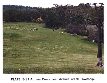
Work on paper (Sub-Item) - Photograph, Arthurs Creek near Arthurs Creek township, 1976
Colour photograph of Arthurs Creek near Arthurs Creek township. Hilly grassed landscape with cattle in the backgroundarthurs creek, cattle, farm -
 Marysville & District Historical Society
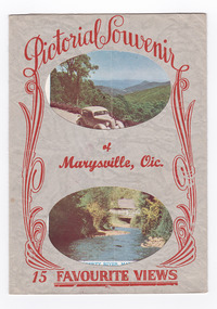
Postcard (item) - Colour and black and white photographs, Murray Views, Pictorial Souvenur of Marysville, Vic. 15 Favourite Views, 1950's
A fold out postcard of 15 colour and black and white photographs of scenes and landscapes in and around Marysville in Victoria.A fold out postcard of 15 colour and black and white photographs of scenes and landscapes in and around Marysville in Victoria. These photographs were produced by Murray Views in Gympie, Queensland as a souvenir of Marysville.Pictorial Souvenir/ of/ Marysville, Vic./ 15 Favourite Views PRODUCED BY MURRAY VIEWS. GYMPIE. Q. COPYRIGHT SAMUEL LEE & CO., PRINTERS Serial No. R 4152 NICHOLL'S LOOKOUT, MARYSVILLE, VIC. TAGGERTY RIVER, MARYSVILLE, VIC ROAD SCENE, MARYSVILLE, VIC. MAIN STREET, MARYSVILLE, VIC. THE CROSSWAYS, MARYSVILLE, VIC. FRUIT SALAD FARM, MARYSVILLE, VIC. ROAD TO CUMBERLAND VALLEY, MARYSVILLE, VIC. CROSSWAYS CABARET, MARYSVILLE, VIC. TREE FERNS, MARYSVILLE, VIC. STEVENSON'S FALLS, MARYSVILLE, VIC. Looking towards Marysville, Vic. Tourists at Marysville, Vic. Taggerty River, Marysville, Vic. On Buxton Road, Marysville, Vic. Panorama from Black Spur, Marysville Road, Marysville, Vic.marysville, victoria, souvenir, postcard, nicholl's lookout (image 1), taggerty river (image 2), road scene (image 3), main street marysville (image 4), crossways hotel (image 5), fruit salad farm (image 6), cumberland valley (image 7), crossways cabaret (image 8), tree ferns (image 9), steavenson falls (image 10), marysville view (image 11), tourists marysville (image 12), taggerty river (image 13), buxton road (image 14), black spur (image 15) -
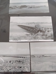 Peterborough History Group
Photograph - Four copies of photographs of the Peterborough Old Bridge
Varying views of the old bridge, which was a valuable connection to the East side of the river. A view of the landscape at that time.Historic views of the town and bridge 4 photocopied reproductions of different aspects of the Old bridge at Peterborough, including one which is a copy of The Rose Series Postcards No P2470.peterborough, peterborough old bridge, curdies river bridge, rose series postcards, rose series p2470