Showing 126298 items
matching main-road
-
 Kew Historical Society Inc
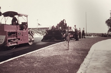
Photograph, Public Works, Road Construction, 1950s
An original photograph donated to the Kew Historical Society by the City's Engineering Department before the amalgamation of Kew into the City of Boroondara in 1994.While not all of the photographs are of Studley Park, Kew or East Kew, each photo provides a fine snapshot of the work of local government engineering departments of the period. They reveal they types of labour conducted, the techniques used and the equipment and machinery in the possession of the local government authority. Public works. Road making in the 1950s using a steam roller and a mechanical grader. Inscription on reverse: "Road making." city of kew (engineering department), road construction building, road maintenance -
 Kew Historical Society Inc
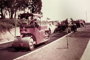
Photograph, Public Works, Road Construction, 1950s
An original photograph donated to the Kew Historical Society by the City's Engineering Department before the amalgamation of Kew into the City of Boroondara in 1994.While not all of the photographs are of Studley Park, Kew or East Kew, each photo provides a fine snapshot of the work of local government engineering departments of the period. They reveal they types of labour conducted, the techniques used and the equipment and machinery in the possession of the local government authority.Public works. Road making in the 1950s using a steam roller and a mechanical grader. Inscription on reverse: "Road making." city of kew (engineering department), road construction -
 Ringwood and District Historical Society
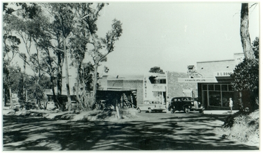
Photograph, Mansourah Picture Framing, Buildings in Canterbury Road Heathmont, February 1960, Feb-60
Peter Le Get found three framed photos of Heathmont view in a Heathmont Opportunity Shop. Previous owners unknown.Framed photograph of buildings in Canterbury Road Heathmont, February 1960.Heathmont, February 1960, Canterbury Road -
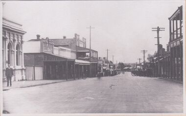
 Stawell Historical Society Inc
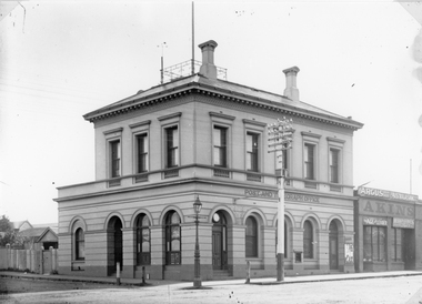
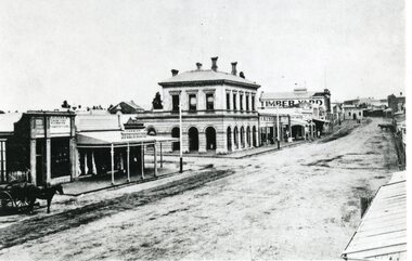
Photograph, Stawell Post Office Cnr Wimmera and Main Streets 1875
Stawell Post Office on corner of Wimmera and Main Streets. Erected 1875. Telegraph pole and streetlamp in foreground. Akins store visible at right of photo. The building has 3 arched doors & 6 arched windows on the ground floor and 8 square windows on the top story. Two chimneys on the roof and a wrought iron square fence on the roof. The outside of the building has not changed while the interior has been remodelled several times. The early Postmasters and their families lived upstairs. The main room originally included the Telegraph office where operators worked at machines, sending and receiving Morse code messages. Later alterations were made for a telephone switchboard room downstairs, with trunk line equipment upstairs. In 1965 the telephone system was converted to automatic.Black & white photo of a two story building on the corner of Wimmera & Main St. The building the Stawell Post and Telegraph Office. Out the front of the Post office is a telegraph pole and a light post. Next door in Main St is a single story building with a sign over the building Argus Australasian, underneath Akins, Age/Leader possible a newsagent. stawell -
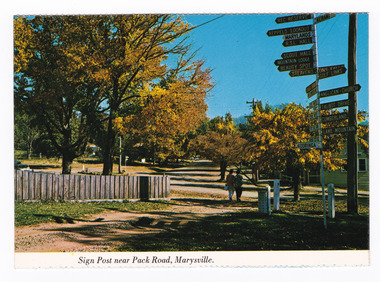 Marysville & District Historical Society
Postcard (item) - Colour postcard, Nucolorvue Productions Pty. Ltd, Sign Post near Pack Road, Marysville, Pre 2009
A colour photograph of the sign post that once stood opposite Pack Road in Marysville in Victoria.A colour photograph of the sign post that once stood opposite Pack Road in Marysville, Victoria. This corner was known as Signpost Corner. This postcard was produced by Nucolorvue Productions as a souvenir of Marysville.NU-COLOR-VUE/ OF/ AUSTRALIA MARYSVILLE, VICTORIA./ Sign post opposite Pack Road at/ Autumn. PLACE/ STAMP/ HERE POST CARD NCV.170 - NUCOLORVUE PRODUCTIONS PTY. LTD./ COPYRIGHT Printed in Australiamarysville, victoria, sign post, postcard, souvenir, nucolorvue productions, signpost corner, pack road -
 Rutherglen Historical Society
Image, c1930
Building on left of street, in the foreground was originally the Bank of Victoria, and is now the NAB. Further along on that side is the Rutherglen Hotel, now Poachers Paradise. In the foreground on the right, is the Star Hotel.One of three black and white photographs, mounted on orange paper. This one is of Main Street, looking west from the corner of High Street. Written on mount: "Looking west from cnr High & Main St. Circa 1930's"main street, bank of victoria, nab, rutherglen hotel, poachers paradise hotel, star hotel, hotels, banks -
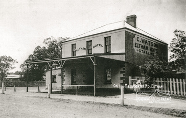 Eltham District Historical Society Inc
Photograph, On the Melbourne Road; C. Watson's Eltham Hotel and Stables
The 1852 owner was Benjamin O'Wallis who died in 1896Photocopy of a photograph of C. Watson's Eltham Hotel, cnr. Main Road and Pitt Street, Elthamhotels, eltham, c watson, main road, pitt street, benjamin o'wallis -
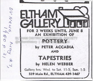 Eltham District Historical Society Inc
Document - Property Binder, 559 Main Road, Eltham
Newspaper advertisement: Diamond Valley News, 27 May 1980, Exhibition, Peter Accadia, pottery, and Helen Webber, tapestries. Newspaper article: Five for the price of one, Diamond Valley News, Tuesday, July 8, 1986, p27; exhibition of five artists at Eltham Gallery. On reverse, numerous advertisements for food and entertainment Newspaper advertisement: The Age ,17 June 1989, Exhibition, Donald Ramsay "Watching the river flow". Newspaper article: Landmark gallery says goodbye, Diamond Valley Leader, 24 November 2004, Gallery site sold to Sentinel Equities, present tenant Julie Skate, quotes from former part-owner Val Murray. Newspaper article: Rift over gallery plans, Diamond Valley Leader, 21 February 2007, purchasers Jethro Tull and Suzanne Still plan to build offices, gallery and cafe; Eltham Gateway Action Group objected while supporting need for a gallery elsewhere. Newspaper article: New try for gallery-cafe ready soon, Diamond Valley Leader, 18 April 2007, purchaser Jethro Tull to have a new plan ready in two weeks for gallery and cafe. Newspaper article: Gateway for artists, Diamond Valley Leader, 25 May 2007, Jenni Mitchell opened a new gallery pending decision by Nillumbik Council. Newspaper article: Art gallery proposal rejected, Diamond Valley Leader, 30 May 2007, Nillumbik Council against planned new building. Newspaper article: Artful win for gallery, Diamond Valley Leader, 30 January 2008, VCAT approved mudbrick art gallery. Newspaper article: Rocky road to create a landmark, Diamond Valley Leader, 13 February 2008, VCAT approved Robert Marshall's design, artists's impression, Eltham Gateway Action Group opposed.main road, property, businesses, eltham gallery, wiregrass gallery, eltham gateway action group, robert marshall, mud brick building, eltham (vic), 559 main road eltham, artists, bernhard rust, bob smith, jan neil, john adams, marian sussex, michael wilson, tony dopheide, 47-55 main street diamond creek, 50 were street montmorency, 55 rattray road montmorency, 410 main road lower plenty, abbey of diamond creek, adams north riding restaurant, advertising, eltham barrel, montmorency, mustard seed restaurant, peking house restaurant, st andrews, tamara's -
 Stawell Historical Society Inc
Photograph, Green Grocers Shop at 150 Main Street Stawell with Restored Verandah & Posts
Business Premises 150 Main Street restored with verandah posts. Earlier owned by F. Allah who conducted a Green Grocers there.Black & white restored building at 150 Main Street Stawell. Now and accountant's offices. Previous owner F. Allan conducted a greengrocer business. The two story building restored with veranda posts.stawell -
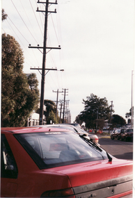 Whitehorse Historical Society Inc.
Photograph, Whitehorse Road, 1/06/1999 12:00:00 AM
Coloured photo of Whitehorse Road, Mitcham, opposite Doncaster East Road looking toward Mitcham Road.whitehorse road, overhead powerlines -
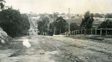 Ringwood and District Historical Society
Photograph, Looking south down Warrandyte Road, Ringwood around 1920
Black and white photograph taken just below where Mullum Mullum Road meets Warrandyte Road.The Mullum Mullum Bridge can be seen in the dip, with numerous houses on the ridge on Whitehorse Road (Maroondah Highway). The fencing was post and rail, with Warrandyte Road unmade, sealed with crushed rocks. -
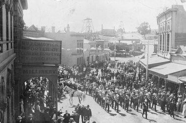 Stawell Historical Society Inc
Photograph, Upper Main Street Stawell procession with the band & a police constable on Horseback visible c1901
Main Street Procession East End Circa 1901. Stawell Brass Band plus Constable on Horseback visible. J Chadwick Importer of General Drapery with Boys Clothing on sign on left. Millinery on side of verandah. Commercial Hotel just visible on left. Sloane's & Scotchmans Poppet head Visible in background on right. Poppet Head in background on Big Hill on left is Crown Cross shaft.Croud of people lead by band in upper main street. Chadwick drapers on left. Mounted policeman on horseback in front of Commercial Hotel.stawell businesses streetscape -
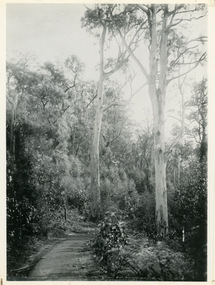 Mt Dandenong & District Historical Society Inc.
Photograph, Jasper Road Near Erith Lane 1920, 1920
View of Jasper Road, near Erith Lane taken in 1920. The road is tree lined with two significant gum trees in the foreground. This photograph has a detailed inscription on the back handwritten by John Lundy-Clarke in 1974.Jasper Road near Erith Lane 1920. This road has only a narrow right of way. It was put in as a road to serve “Cherry Farm”, connecting it to the Coach Road at the Elbow in 1904. It joins a wide surveyed road running from Inverness Road to the Coach Road at the Elbow and could possibly have been surveyed by Thomas Hand at the same time as Inverness Road. The name Jasper now applies to full length between Erith Lane and Coach Road. McGivern Bros widened it in 1937 and J L Clarke removed and stored much of the rock quarried in the widening. This was later sold to Dick Moorby who sold it to the builders of St Michaels Church in Falls Road. Comment by John Lundy-Clarke 10.5.1974 jasper road, erith lane, john lundy-clarke -
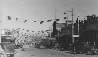 Stawell Historical Society Inc
Photograph - Upper Main Street looking West, Upper Main Street with Bunting looking West & Named Shops in 2nd Photo -- 2 Photos
Main Street Stawell c 1940 On left Bike Shop, Carters Boot Shop. On right under town Hall Tower is Stawell Post Office, T. Browns Furniture / Coles / Eales, Geo Mitchell & Sons, Norman A. Harding Men's Wear. J.T. Chaponnel.Main street scene looking west with bunting across street. Many 1940's vehicles in streetboth driving and parked. Delivery truck at centre of image.stawell streetscape -
 Whitehorse Historical Society Inc.
Newspaper - Article, 25-29 Glenburnie Road, Mitcham, 15/05/1996
Sale advertisement for 25 - 29 Glenburnie Road, Mitcham, known as 'Old Daffodil Farm'. Also 95 Morack Road, Vermont South for auction.glenburnie road, mitcham, nos. 25-29, old daffodil farm, morack road, vermont south, no. 95, auctions -
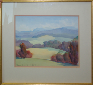 Federation University Art Collection
Painting - Watercolour, 'Towards Avoca' / 'Mount Buninyong in Autumn' by David Alexander, 1999
This item is part of the Federation University Art Collection. The Art Collection features over 1000 works and was listed as a 'Ballarat Treasure' in 2007.Unframed double sided landscape artwork by David Alexander. One side is 'Towards Avoca' and the other side is 'Buninyong From Main Road, 24/04/1999'David Alexander wrote on 'Buninyong From Main Road, 24/04/1999' "Wash wouldn't dry. People everywhere"art, artwork, david alexander, alexander, buninyong, avoca, watercolour -
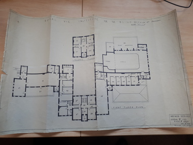 Vision Australia
Plan - Image, Royal Vic Institute for the Blind Hirings Service, 18/12/1943
Plan of the first and second floors of the main building at 557 St Kilda Road, created by the RAAF during it's occupation of the same between 1942-1944.1 architectural plan of St Kilda Road main buildingroyal victorian institute for the blind, plans, raaf -
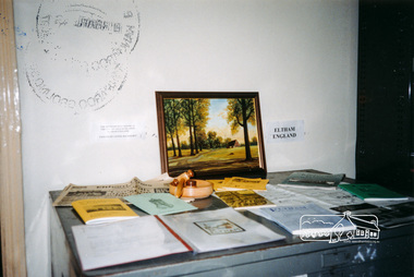 Eltham District Historical Society Inc
Photograph, Local History Centre display for Opening Day, 12 Jul 1998
Opening Ceremony of Local History Centre, 728 Main Road, Eltham, Sunday, July 12th, 19982 colour photographseltham, main road, police residence, local history centre, eltham district historical society, opening day -
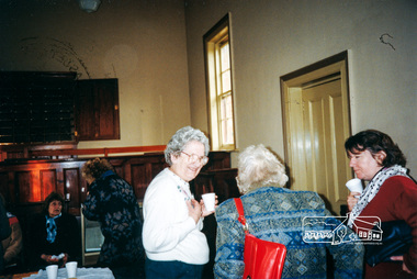 Eltham District Historical Society Inc
Photograph, Afternoon Tea in the Courthouse in celebration of the opening of the Local History Centre, 12 July 1998, 12/07/1998
Opening Ceremony of Local History Centre, 728 Main Road, Eltham, Sunday, July 12th, 19982 colour photographseltham, main road, police residence, local history centre, eltham district historical society, opening day, doug orford, gwen orford, jo mccormick, john graves, mary ryan, opal smith, peter bassett-smith -
 Stawell Historical Society Inc
Photograph, Upper Main Street Looking East 1886
Upper Main Street Looking East 1886. From left J Allingham Drapers. J Chadwick & Co Drapers. Bank of Victoria partly obscured, Commercial Hotel, Oriental bank, Punchard's Furniture. On right is the side of Mechanics Institute obscured. B.S. Dawson Chemists & Wadsworth Watchmaker. English Scottish & Australian Bank . Upper Main Street scene with people standing in roadway, Side of cart visible on left. c 1880stawell streetscape -
 Glen Eira Historical Society
Album - Album page, Nithsdale now Five Way Hill, Kambrook Road, Circa 1972
This photograph is part of the Caulfield Historical Album 1972. This album was created in approximately 1972 as part of a project by the Caulfield Historical Society to assist in identifying buildings worthy of preservation. The album is related to a Survey the Caulfield Historical Society developed in collaboration with the National Trust of Australia (Victoria) and Caulfield City Council to identify historic buildings within the City of Caulfield that warranted the protection of a National Trust Classification. Principal photographer thought to be Trevor Hart, member of Caulfield Historical Society. Most photographs were taken between 1966-1972 with a small number of photographs being older and from unknown sources. All photographs are black and white except where stated, with 386 photographs over 198 pages. Glen Eira Heritage Management Plan (1996) by Andrew Ward and Associates - Vol 3 "Nithsdale", built for J.S. Crouchin 1858 and extended in 1885 with a tower and associated rooms, survives as testimony to the nineteenth century occupation of the vicinity of the Kambrook/Glen Eira Road intersection. Caulfield's Building Heritage by Dr Geulah Solomon, Vol 1 p49 records it as a small Victorian mansion home on bluestone foundations of Italianate style with a tower. Built for J S Chambers circa 1860, it was built in stages and then the land subdivided in the 1920s. Other owners include Adolph F Brockhoff (of Brockhoff Biscuits company). Names used besides Nithsdale have been Bundoora and Five Way Hill. Page 102 of Photograph Album with four photographs (three landscape and one portrait) of Nithsdale, now known as Five Way Hill. Three views of the tower and one of the house.Handwritten: "Nithsdale" now "Five Way Hill" Kambrook road [top right] / CNR KAMBROOK AND GLENEIRA ROADS [under bottom right photo] / 102 [bottom right]trevor hart, north caulfield, victorian, mid victorian, late victorian, tower, j.s. crouchin, 1850's, 1880's, italianate, rendered, five way hill, nithsdale, slate roof, plaster arches, ornamental columns, triangular pediment, ornamental parapet, cast iron balconies, kambrook road, glen eira road, t crouch, j s crouchin, mansions, j s chambers, bluestone foundations, land subdivision, adolph f brockhoff, bundoora, house names -
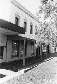
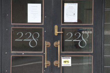 Kew Historical Society Inc
Photograph - Photographs (series), Richard Bowen, Sunninghill, 228 Cotham Road, 07/02/2020
'Sunninghill' at 228 Cotham Road (Kew) is an historically significant building due to its associations with Joseph Thomas (Bland) Holt (1851-1942), theatre entrepreneur and actor who lived at the house following his retirement in 1909. Sunninghill (aka Sunning Hill) was one of his residences in Victoria (also 'The Anchorage' at Sorrento). Following Holt's death at Sunninghill on 28 June 1942, the house was left to his wife. After her death the house was bequeathed to Lucy Coppin, daughter of George Coppin. The 'Shakespeare Window' in the State Library of Victoria was at one stage installed in the house. References 'Death of Mr Bland Holt: Great exponent of melodrama', The Argus, 30 June 1942, p. 3. Shoesmith D, 'Holt, Joseph Thomas (Bland) (1851-1942)', Australian Dictionary of Biography, Vol 4, 1972. 'The Shakespeare Window', State Library of Victoria website.Exterior photographs (digital) of Sunninghill, 228 Cotham Road, Kew VIC 3101. sunninghill - 228 cotham road - kew (vic), joseph thomas (bland) holt, lucy coppin -
 Glen Eira Historical Society
Album - Album page, St Stephen's Presbyterian Church, Balaclava Road, Circa 1972
This photograph is part of the Caulfield Historical Album 1972. This album was created in approximately 1972 as part of a project by the Caulfield Historical Society to assist in identifying buildings worthy of preservation. The album is related to a Survey the Caulfield Historical Society developed in collaboration with the National Trust of Australia (Victoria) and Caulfield City Council to identify historic buildings within the City of Caulfield that warranted the protection of a National Trust Classification. Principal photographer thought to be Trevor Hart, member of Caulfield Historical Society. Most photographs were taken between 1966-1972 with a small number of photographs being older and from unknown sources. All photographs are black and white except where stated, with 386 photographs over 198 pages. From: Glen Eira Heritage Management Plan (1996) by Andrew Ward and Associates In 1905, the land was vacant in Balaclava Road, north side, from Kooyong Road east to the right of way, except for one house. A block of this land was acquired by the Presbyterian community and a timber church erected there in 1910. In time, a larger church was required. After several years of fund raising led by George Kinross, a new red brick St Stephen's church was built in 1926 to the design of architects Haddon and Henderson. George Currie was the builder and the cost of construction was £5,100.From: Glen Eira Heritage Management Plan (1996) by Andrew Ward and Associates: St Stephens has architectural importance as a noteworthy example of a Gothic Transitional design in the Arts and Crafts eclectic manner (see Stylistic Typology in National Trust's Historic Church's Study}. The facade treatment successfully combines Christian symbols with Gothic forms in the Arts and Crafts mode (comparable with Haddon's Presbyterian Church, Malvern (1906) and Haddon and Henderson's Oakleigh Church (1928). It is locally important as an example of Robert Haddon's work in Caulfield, where he also lived (4 Glenferrie St q.v.).Page 26 of Photograph Album including three black and white photographs of St Stephen's Presbyterian Church, with two photographs in portrait mode across the top showing 2 different stained glass windows from the inside; and one in landscape mode in the bottom section which appears to be a photograph of a framed photograph or drawing of the church.Hand written: St Stephen's Presbyterian Church Balaclava Road [top right] / 26 [bottom right]trevor hart, caulfield north, balaclava road, george kinross, haddon and henderson, george currie, st stephen's, 1900's, 1920's, gothic transitional, christian symbols, arts and crafts, robert haddon, stylistic typology, gothic, drawings, presbyterian church, architects, lead lights, stained glass windows -
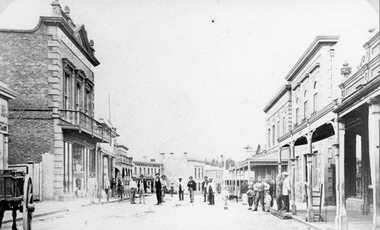
 Rutherglen Historical Society
Image, c1900
One of three black and white photographs mounted on orange paper. This one is of Main Street Rutherglen, featuring the Victoria Hotel. The Standard Bakery is visible further up the street.At top left of photo: "Main Street, East Rutheglen" Caption on mount: "Victoria Hotel"victoria hotel, hotels, pubs, main street, standard bakery -
 Stawell Historical Society Inc
Photograph, Main Street Stawell looking East across Wimmera Street to Post Office
Main Street Stawell looking east across Wimmera Street to Post Office. Horse Drawn cart at left of Photo. Star Hotel on right in the distance.B/W Photo Main Street looking east with the Post Office on the left. It is interesting to note that the Star Hotel is way out of line it seems to block the street. It was shifted back and is now the Stawell Club.stawell businesses streetscape -
University of Melbourne, Burnley Campus Archives
Photograph - Black and white print, 25. Main Entrance
View from entrance gate.Labelled,"Main Entrance."entrance gate, mrs. jessep, alexander william jessep, principal, a.w. jessep -
 Melbourne Tram Museum
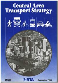
Document - Report, Road Traffic Authority, "Central Area Transport Study", Dec. 1988
Report - 108 pages + card cover, centre stapled, titled "Central Area Transport Study", produced by the Road Traffic Authority as part of the Central Area Transport Strategy (CATS), with a forward by the Minister for Transport Jim Kennan, has a table of contents, figures and tables. Provides a set of Action Plans, looks at future development areas around Melbourne, options, roads, tram and rail lines, cycle and pedestrians. Draft document. See Reg Item 1582 for a March 1991 version.Has pen marks high lighting various paragraphs.trams, tramways, public transport, melbourne, road transport, the met, minister for transport -
 Ringwood and District Historical Society
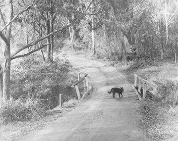
Photograph, Deep Creek Road early 1900s
Black and white photograph of bend in unmade road. Bridge with black dog standing on bridge. Forest area on either side of road. (2 copies)Typed below photograph, "Deep Creek Road in early days". -
 Stawell Historical Society Inc
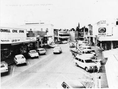
Photograph, Upper Main Street Removal of Verandahs, 1960's
Stawell Civic Store, Senghpa's, Commercial Hotel, Oriental Bank/Bank of Australasia, ES & A Bank Upper Main Street Taken from higher up with cars in Main Street looking eastThe removal of verandahs from shop frontsstreetscape -
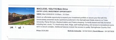 Greensborough Historical Society
Advertising Leaflet, 102c/116 Main Drive Macleod, 23/05/2018
102c/116 Main Drive Macleod, Studio apartment in secure complex. Sold May 2018 for $124,900Real estate advertising leaflet, 1 sheet, printed in colour.main drive macleod