Showing 25603 items matching "plenty-township-estate"
-
 Malmsbury Historical Society
Photograph (Item), "House In Malmsbury C1990, Real Estate Photo, Sold", Malmsbury c1990
Buildings - House Associated with - "Real Estate Agent, Kyneton Hist Soc" -
![Advertising Leaflet, Grace Park Electric Station Estate, Watsonia [1], 21/06/1924](/media/collectors/4f729f5697f83e03086015b8/items/5dcfb6fc21ea671434eb6c09/item-media/5dcfb72a21ea671434eb91fa/item-fit-380x285.jpg) Greensborough Historical Society
Greensborough Historical SocietyAdvertising Leaflet, Grace Park Electric Station Estate, Watsonia [1], 21/06/1924
Digital copy of auction leaflet for sale of land known as Grace Park Electric Station Estate, Saturday 21/06/1924. Auctioneer Knight & Harwood in conjunction with C. Jessop. This leaflet shows a home on the estate and a photograph of the proposed site of the 'Grace Park Railway Station'.Digital copy of auction leaflet 1 page. Black and red text on white paper.watsonia, grace park -
 Kew Historical Society Inc
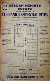
Plan - Subdivision Plan, Osburn Heights Estate, 1938
Edward Haughton & Co, in promoting the Osburn Heights Estate in what is now Balwyn North, attempted to capitalize on the subdivision’s proximity to East Kew. One section of the plan is includes the text: ‘The New Suburb: Camberwell North or East Kew (the names are synonymous)’. The Osburn Heights subdivision was part of a series of subdivisions running between Doncaster Road and Maud Street, including the ‘Pointed Firs Estate’ (MAP.0010). This subdivision included 13 ‘grand residential sites’ for sale in Doncaster Road, Maud Street and Osburn Avenue.subdivision plans - camberwell north, osburn heights estate -
 Ringwood and District Historical Society
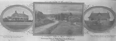
Photograph, Strip of images used for Ringwood Heights Estate land sale promotion - 1924
Strip of 3 views apparently part of a land sale advertisement - View of Whitehorse Rd between photos of two Whitehorse Rd houses.Typed on back of photographs, "Ringwood Heights Estate. Land on left of road and down to Mullum Creek. Sold by T. Grant. 97 lots, 1st March 1924. J.B. McAlpin, agent. No deposit, 1 pound per month." -
 Whitehorse Historical Society Inc.
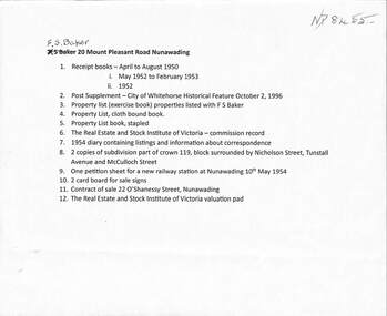
Document, F. S. Baker Real Estate Agent, 1950
F. S. Baker Real Estate Agent business booksA collection of business booksnon-fictionF. S. Baker Real Estate Agent business booksbaker f s, real estate agents -
Broadmeadows Historical Society & Museum
Photograph, Children on the Banksia Gardens Estate, 23 March 1990
This black and white photo, originally published in the Broadmeadows Observer, depicts children on the Banksia Gardens Estate in Broadmeadows. One child holds an umbrella in a paddock, symbolising the community's resilience. The estate, initially plagued by social challenges, has transformed through community services and recent housing developments.This black and white photograph, originally published in the Broadmeadows Observer, captures a group of children on the Banksia Gardens Estate, Broadmeadows, with one child holding an umbrella in a paddock. The image symbolises the community's resilience. Initially plagued by social challenges, the estate has transformed through community services and recent housing developments, highlighting the strength and progress of the local community.Black and white photograph on glossy photographic paper.1 Torn Label: Photographers Caption SH/Date 23/3/90 Publication OB/Operator's Name Leich/Assignment Banksia GA/Names and Initials Adsage/(in block letters/from left to right) Green Label: The Leader Newspaper Group/The Northern Division/Paper 30/Catchline ME39BO700/Percentage 112/Date/Page 8banksia gardens estate, broadmeadows, children, broadmeadows observer, 1990 -
 Greensborough Historical Society
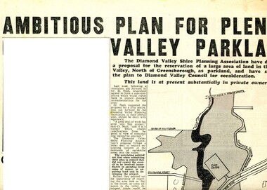
Newspaper Clipping - Digital Image, Ambitious plan for Plenty Valley Parklands 1965, 05/11/1965
In 1965, the Diamond Valley Shire planning association recommended to Council that a large area of land north of Greensborough be acquired for Parkland. The idea of a Civic Centre was included with a map of the area from Grimshaw Street in the south to the MMBW pipeline reserve in the north. Includes a suggested new site for the local school, near Yando Street. This area is now part of the Plenty River Trail.An example of developments in the Greensborough area during the period of Shire of Diamond ValleyNews clipping, black and white text and map. Scanned in 3 parts.shire of diamond valley, civic drive greensborough, yando street greensborough, partingtons flat, plenty river trail -
Malmsbury Historical Society
Photograph (Item), "Shop In Malmsbury C 1990, Real Estate Photo", Malmsbury c1990
Buildings - "Shops, Gutters" Associated with - "Real Estate Agent, Kyneton Hist Soc" -
 Malmsbury Historical Society
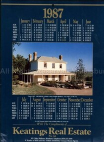
Photograph (Item), Pattens Hill Drummond On 1987 Real Estate Calendar, Malmsbury c1987
People - Patten Family Buildings - House Associated with - Keatings Real Estate Woodend -
 Malmsbury Historical Society
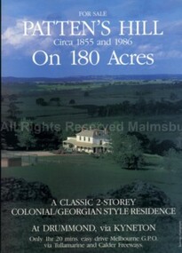
Photograph (Item), Pattens Hill Real Estate Advertising C1986, Malmsbury c1986
People - Patten Family Buildings - House Associated with - Keatings Real Estate Woodend -
 Eltham District Historical Society Inc
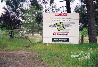
Photograph, Real Estate Auction Sale: 100 Flat Rock Road, Kangaroo Ground, 17 November 1992, 1992
Deceased estate sold by Peter McDougall of The Professionals; 23 acres in size on 2 titles in a prime position, with a made road frontage and close to the Pony Club with an easy drive to Eltham, Greensborough and Melbourne. Ian Mason of Mason White McDougall Real Estate advised (via Facebook) that two local builders battled it out at the auction run by Tony McDougall and that there are houses now on both titles. It was one of the first sales that Ian was involved with in his career, starting out at Peter McDougall Real Estate.Roll of 35mm colour negative film, 4 strips Fuji 100flat rock road, houses, ian mason, kangaroo ground, kangaroo ground pony club, peter mcdougall real estate, real estate agent, tony mcdougall -
 Whitehorse Historical Society Inc.
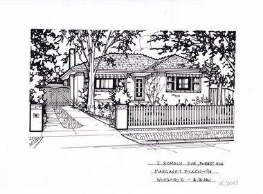
Artwork, other - Ink Line Drawing, Margaret Picken, 2 Romoly Dve., Forest Hill, 2003
A property illustration by Margaret Picken Commissioned by the real estate agency Woodards Real Estate Blackburn for the purpose of advertising 2 Romoly Dve., Forest Hill. This property is listed as having sold for $135,100 in 1994. Made by using Rotring ‘Rapidigraph’ drafting pens with Rotring ink on Rapidigraph polyester drafting film, double matte. Trained as a cartographic draftsman within the mining industry, Margaret Picken is an artist who worked producing property illustrations for real estate agencies in eastern suburbs of Victoria from 1983-2005. Retiring from the industry as technological changes favored coloured photography over illustrations, and commissioning companies over sole contractors.This artwork is of Historical Significance as a record of local domestic architecture.A black ink line drawing on drafters film by Margaret Picken, of 2 Romoly Dve., Forest Hill, of a single story brick house set back from a picket fence and front yard with shrubbery and trees. To the left is a driveway leading to a picket gate. There are two hole punch holes near the centre of the upper edge.2 Romoly Dve., Forest Hill Picken - 94 Woodards - B/burnwhitehorse historical society, schwerkolt cottage, housing, architecture, margaret picken, house, garden, forest hill, real estate -
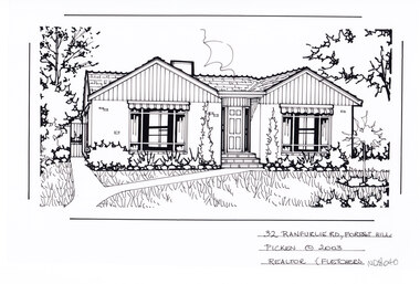 Whitehorse Historical Society Inc.
Artwork, other - Ink Line Drawing, Margaret Picken, 32 Ranfurlie Rd., Forest Hill, 2003
A property illustration by Margaret Picken Commissioned by the real estate agency Fletchers Real Estate for the purpose of advertising 32 Ranfurlie Rd., Forest Hill. This property is listed as having sold for $363,500 in 2003. Made by using Rotring ‘Rapidigraph’ drafting pens with Rotring ink on Rapidigraph polyester drafting film, double matte. Trained as a cartographic draftsman within the mining industry, Margaret Picken is an artist who worked producing property illustrations for real estate agencies in eastern suburbs of Victoria from 1983-2005. Retiring from the industry as technological changes favored coloured photography over illustrations, and commissioning companies over sole contractors.This artwork is of Historical Significance as a record of local domestic architecture.A black ink line drawing on drafters film by Margaret Picken, of 32 Ranfurlie Rd., Forest Hill, of a path leading to a back gate and a door of the single story brick house, set back from a front lawn.32 Ranfurlie Rd., Forest Hill Picken © 2003 Realtor (Fletcherswhitehorse historical society, schwerkolt cottage, housing, architecture, margaret picken, house, garden, forest hill, real estate -
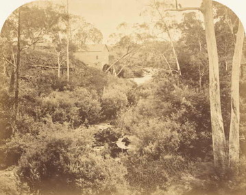 Greensborough Historical Society
Photograph (copy), Willis's Mill, 1855c
Photograph of ruins of early flour mill on Plenty River.http://www.mintinc.com.au/pdf/carome_mill_arch_report.pdf Detailed report on same.A photocopy of a photograph of Willis's Flour Mill located on the Plenty River behind Carome Station Mernda.Nilplenty river, flour mill, mernda, yan yean reservoir, riparian rights, 1840, fred kruger, williss mill -
 Eltham District Historical Society Inc
Document - Folder, Bridgeland Estate, Eltham South, 1998
Various documents, including a history, letter and reminscences relating to properties of the Bridgeland Estate including Antoinette Boulevard and Leonard Crescent, Eltham South. 5 photocopies of parts of maps relating to subdivisions from 1842 to the 1925 Bridgland Park Estate Folders 78 and 80 from Harry Gilham Collection 12 pagesantoinette boulevard, leonard crescent, eltham south, bridgeland park estate, harry gilham collection -
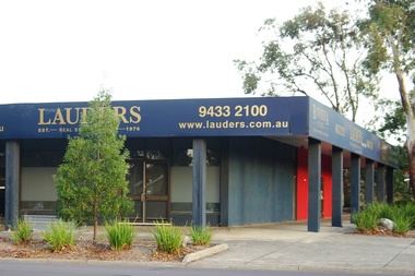 Greensborough Historical Society
Photograph - Digital image, Marilyn Smith, Lauders Real Estate Watsonia, Diamond Village Shopping Centre 2016, 22/05/2016
Lauders Real Estate Watsonia at Diamond Village Shopping Centre, Nepean Street Watsonia.Digital copy of colour photograph.diamond village shopping centre, lauders real estate, watsonia -
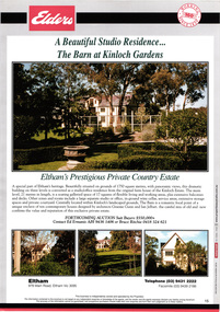 Eltham District Historical Society Inc
Document - Brochure, The Barn at Kinloch Gardens; Elders Real Estate sales material, 1998
Description by Elders Real Estate: A Beautiful Studio Residence: The Barn at Kinloch Gardens Eltham's prestigious Private Country Estate A special part of Eltham's heritage. Beautifully situated on grounds of 1750 square metres with panoramic views, this dramatic building on three levels is converted to a ? office residence from the original farm house of the Kinloch Estate. The main level, 21 metres in length, is a soaring galleried space of 17 squares of flexible living and working areas, extensive storage spaces and private courtyard. Centrally located within Kinloch's landscaped grounds. The Barn is a romantic focal point of a unique enclave of ten contemporary house designed by Graeme Gunn and Ian Jelbart, the cultural mix of old and new confirms the value and reputation of this exclusive private estate. Digital file only; created from scan undertaken by EDHS of item on loanarthur street, elders real estate, eltham, houses, jelbart property, kinloch gardens, real estate agent, the barn, woodridge estate -
 Eltham District Historical Society Inc
Slide - Photograph, Near the old Lower Plenty Bridge (present day Edward Willis Court), c.Aug. 1990
Part of a presentation, "Roads and Byways of the Shire of Eltham", by Russell Yeoman to the 12 September 1990 Society meeting. Slides shown included copies of old photos and recent images ranging from the suburban streets of Eltham and Montmorency to the mountain roads of Kinglake. In the byways category are views of some iof the Shire's bicycle paths including then recently completed sections of the Main Yarra Trail at Lower Plenty.35mm colour positive transparency (1 of 37) Mount - Agfachrome Agfa CS System black 8 dotsinfrastructure, roads, edward willis court, lower plenty, lower plenty bridge -
 Eltham District Historical Society Inc
Slide - Photograph, Aerial Photo (c.1987): Main Road, Fitzsimons Lane, Lower Plenty, c.Aug. 1990
Part of a presentation, "Roads and Byways of the Shire of Eltham", by Russell Yeoman to the 12 September 1990 Society meeting. Slides shown included copies of old photos and recent images ranging from the suburban streets of Eltham and Montmorency to the mountain roads of Kinglake. In the byways category are views of some iof the Shire's bicycle paths including then recently completed sections of the Main Yarra Trail at Lower Plenty.35mm colour positive transparency (1 of 37) Mount - Agfachrome Agfa CS System black 8 dotsinfrastructure, roads, aerial photographs, roundabout, bolton steet, bolton steet shops, eltham, fitzsimons lane, lower plenty, main road -
 Eltham District Historical Society Inc
Slide - Photograph, Main Yarra Trail, Lower Plenty, c.Aug. 1990
Part of a presentation, "Roads and Byways of the Shire of Eltham", by Russell Yeoman to the 12 September 1990 Society meeting. Slides shown included copies of old photos and recent images ranging from the suburban streets of Eltham and Montmorency to the mountain roads of Kinglake. In the byways category are views of some iof the Shire's bicycle paths including then recently completed sections of the Main Yarra Trail at Lower Plenty.35mm colour positive transparency (1 of 37) Mount - Agfachrome Agfa CS System black 8 dotsinfrastructure, bonds road, lower plenty, main yarra trail, roads, significant trees -
 Eltham District Historical Society Inc
Slide - Photograph, Main Yarra Trail, Lower Plenty, c.Aug. 1990
Part of a presentation, "Roads and Byways of the Shire of Eltham", by Russell Yeoman to the 12 September 1990 Society meeting. Slides shown included copies of old photos and recent images ranging from the suburban streets of Eltham and Montmorency to the mountain roads of Kinglake. In the byways category are views of some iof the Shire's bicycle paths including then recently completed sections of the Main Yarra Trail at Lower Plenty.35mm colour positive transparency (1 of 37) Mount - Agfachrome Agfa CS System black 8 dotsinfrastructure, bonds road, lower plenty, main yarra trail, roads, yarra river -
 Eltham District Historical Society Inc
Slide - Photograph, Main Yarra Trail, Lower Plenty, c.Aug. 1990
Part of a presentation, "Roads and Byways of the Shire of Eltham", by Russell Yeoman to the 12 September 1990 Society meeting. Slides shown included copies of old photos and recent images ranging from the suburban streets of Eltham and Montmorency to the mountain roads of Kinglake. In the byways category are views of some iof the Shire's bicycle paths including then recently completed sections of the Main Yarra Trail at Lower Plenty.35mm colour positive transparency (1 of 37) Mount - Agfachrome Agfa CS System black 8 dotsinfrastructure, bonds road, lower plenty, roads -
 Eltham District Historical Society Inc
Slide - Photograph, Main Road, Lower Plenty, c.Aug. 1990
Part of a presentation, "Roads and Byways of the Shire of Eltham", by Russell Yeoman to the 12 September 1990 Society meeting. Slides shown included copies of old photos and recent images ranging from the suburban streets of Eltham and Montmorency to the mountain roads of Kinglake. In the byways category are views of some iof the Shire's bicycle paths including then recently completed sections of the Main Yarra Trail at Lower Plenty.35mm colour positive transparency (1 of 37) Mount - Agfachrome Agfa CS System black 8 dotsinfrastructure, lower plenty, roads, edward willis court, main road -
 Greensborough Historical Society
Article, Norm Colvin, Events leading up to the Plenty Ladies' Petition 1842, 2020_
This article, written and researched by Norm Colvin, GHS Secretary, identifies the people involved in the events leading to the petition to the Governor of Victoria, C. J. La Trobe, from 'Ladies resident on Plenty River' requesting protection from bushrangers, 5 May 1842. It identifies the bushrangers, the owners of the stations robbed, the group of men who rode out to assist and the identity of the "ladies" who signed the petition.This article identifies the people involved in the incidents, a list of locals in the 1840s.12 pages typescript, map.plenty river, bushrangers, petitions -
![Article, Greensborough RSL, Memorabilia: Did You Know [Article on water powered flour mills], 1842o](/media/collectors/4f729f5697f83e03086015b8/items/5091b7fc2162ef017426bfd2/item-media/509a25b52162ef0d908e9725/item-fit-380x285.jpg) Greensborough Historical Society
Greensborough Historical SocietyArticle, Greensborough RSL, Memorabilia: Did You Know [Article on water powered flour mills], 1842o
Contains a brief history of the various flour mills that existed on the Plenty River upstream from Greensborough and some others in the district.Contains some hard to find information on district flour mills and their fate.A one page article on Plenty River flour mills written by Jim Allen.Niljanefield mill, george coulstock, john brock, peter hurlestone, carome mill, thomas mill, plenty river, yan yean reservoir, boadles mill, marsh farm, diamond creek -
 Ringwood and District Historical Society
Newspaper, Newspaper articles detailing the acquisition of 40 acres of land for Jubilee Park, formerly known as Sanders Estate, for recreation purposes
Various newspaper articles about detals of the acquisition, by Ringwood Council, of 40 acres of land for Jubilee Park, formerly known as Sanders Estate, for recreation purposes in 1945-1959. The area included named streets - Prussia Road (not West Prussia Road), Duffy Street, Ireland Street, Evens Street and Chapman Street. -
 Kew Historical Society Inc
Plan - Subdivision Plan, Wimba Estate, Kew, c.1925-c.1929, ca. 1925-ca. 1929
Pru Sanderson, in her groundbreaking ‘City of Kew Urban Conservation Study : Volume 2 - Development History’ (1988), summarised the periods of urban development and subdivisions of land in Kew. The periods that she identified included 1845-1880, 1880-1893, 1893-1921, 1921-1933, 1933-1943, and Post-War Development. These periods were selected as they represented periods of rapid growth or decline in urban development. An obvious starting point for Sanderson’s groupings involved population growth and the associated economic cycles. These cycles also highlighted urban expansion onto land that was predominantly rural, although in other cases it represented the decline and breakup of large estates. A number of the plans in the Kew Historical Society’s collection can also be found in other collections, such as those of the State Library of Victoria and the Boroondara Library Service. A number are however unique to the collection.Subdivision plans are historically important documents used as evidence of the growth of suburbs in Australia. They frequently provide information about when the land was sold on which a built structure was subsequently constructed as well as evidence relating to surveyors and real estate and financial agents. The numerous subdivision plans in the Kew Historical Society's collection represent working documents, ranging from the initial sketches made in planning a subdivision to printed plans on which auctioneers or agents listed the prices for which individual lots were sold. In a number of cases, the reverse of a subdivision plan in the collection includes a photograph of a house that was also for sale by the agent. These photographs provide significant heritage information relating house design and decoration, fencing and household gardens.In 1925, the City of Kew called for tenders for the construction of Wimba Avenue, Cadow Street and Lalla Street. Subsequent advertisements for the sale of land in Wimba Avenue continued from 1926 to 1929. The 18 lots (and a further five allotments on the eastern side of the street) offered for sale were unofficially described in the subdivision plan as the ‘Wimba Estate’. These lots began in Park Hill Road and extended almost to Cotham Road. The subdivision took its name from the house ‘Wimba’ in Cotham Road, which may have formed the southern boundary of the subdivision. (Wimba, at 235 Cotham Road was constructed between 1862-70). The Plan highlights the proximity and advantage of ‘electric’ trams in Cotham and Glenferrie Roads, and the Kew and Glenferrie Railway Stations. An oddity in the Plan is the reference to the electric tram terminus at Burke Road, given that the tramline had already been extended to Mont Albert in 1916.wimba estate, subdivision plans - kew, parkhill road – kew (vic.), normanby road – kew (vic.), wimba avenue – kew (vic.) -
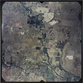 Bacchus Marsh & District Historical Society
Photograph, Aerial image of Bacchus Marsh and Darley in 1994
A whole of town and nearby area aerial image of Bacchus Marsh produced for display in the Arbee Real Estate Agency premises in Main Street, Bacchus Marsh.A large framed colour aerial photograph showing the township of Bacchus Marsh, the neighbouring smaller community of Darley, and the nearby areas of both places. "Bacchus Marsh - Darley. Aerial Photo 27 November, 1994. Presented by Arbee Real Estate "Professionals"'arbee real estate agency bacchus marsh, aerial views bacchus marsh vic. -
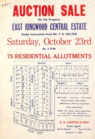 Ringwood and District Historical Society
Flyer, Land Auction Sale Advertisement, East Ringwood Central Estate - 1948
See Victorian Collections reference 5125 for subsequent Central Estate East Ringwood subdivision flyer.Single sided land auction sale advertisement for residential allotments.Auction Sale on the property under instructions from Mr. F.A. Salter. Subdivision includes Dublin Road, Knaith Road, Talofa Avenue, Russet Road, and Shasta Avenue. Agent - C.E. Carter & Son, Main Street, Ringwood. WU 6024.