Showing 3734 items
matching street map
-
 Bendigo Historical Society Inc.
Document - HUSTLERS REEF - NOTES ON HUSTLERS REEF
Notes written in red pen: Ref: B. M. L Hustlers Reef No 1 Page 269. Ironbark Co. 200'. 1857 -'64. (Latham & Watson's Trib. Working Party - see Eclipse Co 28 - 2 - 1865. 200' 1857 - 1859.mining, parish map, hustler's reef, hustlers reef, hustlers reef no 1, ironbark co., latham & watson's trib., eclipse co. -
Bendigo Historical Society Inc.
Map - GREAT EXTENDED HUSTLER'S MINE - LONGITUDINAL SECTION OF THE GREAT EXTENDED HUSTLER'S MINE
Longitudinal Section of the Great Extended Hustler's Mine on the Hustler's Line of Reefs. Bulletin No 33, Plate No XIII. Map shows the Hustler's Tribute, 2 Old Shafts, Great Extended Hustler's Shaft, Latham & Watson's Shaft and Ironbark Gully. Datum Line 750 feet above Sea Level. Poppet Legs on the surface and Sill of Shaft 788.99 feet above Sea Level. Levels and their depths are shown and some geographical features. Some amounts of gold mined mentioned. Geological Survey of Victoria emblem and signed by H A Whitelaw, Underground Survey Office Bendigo, September 1913. Note - Plates 4, 8, 13,20, 26 & 31 form a Longitudinal Section from Fortuna Hustlers to Hustler's Consols Mine. This item has not been scanned or photographed.mining, parish map, great extended hustler's mine, longitudinal section of the great extended hustler's mine, geological survey of victoria, underground survey office bendigo, h a whitelaw, hustler's tribute, old shaft, great extended hustler's shaft, latham & watson's shaft, ironbark gully -
Bendigo Historical Society Inc.
Map - GREAT EXTENDED HUSTLER'S MINE - TRANSVERSE SECTION OF THE GREAT EXTENDED HUSTLER'S MINE
Transverse Section of the Great Extended Hustler's Mine on the Hustler's Line of Reef. Bulletin No 33, Plate No XII. Shows Poppet legs at the surface and Sill of Shaft at 788.99 feet above Sea Level, Cross Cuts and their depths, stone and geographical features encountered and their references and a number of enlarged drawing of sections of the cross cuts, Geological Survey of Victoria emblem and signed by H A Whitelaw, Underground Survey Office Bendigo, September 1913. The depths of crosscuts to No 21 were taken from plans of surveys by Mr Walker and Mr Craven, noted under Reference. Another note: This Saddle Reef is sketched from Mr Walker's plan. Dividends amounting to 360,000 pounds were obtained from it. This item has not been scanned or photographed.mining, parish map, great extended hustler's mine, transverse section of the great extended hustler's mine, old shaft, mr walker, mr craven, geological survey of victoria, underground survey office bendigo, h a whitelaw -
 Bendigo Historical Society Inc.
Map - GREAT EXTENDED HUSTLER'S MINE - PLAN OF THE GREAT EXTENDED HUSTLER'S MINE
Plan of the Great Extended Hustler's Mine. Bulletin No 33, Plate No XI. Shows No 2 Shaft, Latham & Watson's Shaft, levels and their depths and some geographical features. Geographical Survey of Victoria emblem and signed by H A Whitelaw, Underground Survey Office, Bendigo, September 1913. Has reference to photos.mining, parish map, great extended hustler's mine, no 2 shaft, latham & watson's shaft, geological survey of victoria, underground survey office bendigo, h a whitelaw -
Bendigo Historical Society Inc.
Map - FORTUNA HUSTLER'S MINE - TRANSVERSE SECTION OF THE FORTUNA HUSTLER'S MINE
Transverse Section of the Fortuna Hustler's Mine on the Hustler's Line of Reef, Bendigo. Bulletin No 33, Plate No III. Drawing shows poppet legs on the surface and Sill of Shaft 745.38 feet above Sea Level. Shows levels and their depths, geographical features and stone encountered. Reference table to stone and geographical features. Geographical Survey of Victoria emblem. Signed by H A Whitelaw, Underground Survey Office, Bendigo. This item has not been scanned or photographed.mining, parish map, fortuna hustler's mine, hustler's line of reef, geological survey of victoria, underground survey office bendigo, h a whitelaw -
 Bendigo Historical Society Inc.
Map - FORTUNA HUSTLER'S MINE - LONGITUDINAL SECTION OF THE FORTUNA HUSTLER'S MINE
Longitudinal Section of the Fortuna Hustler's Mine on the Hustler's Line of Reef, Bendigo. Bulletin No 33, Plate No IV. Shows poppet legs at the surface level, Datum Line 750 feet above Sea Level, levels and their depths, the amount of gold per ton and some geographical features. Geological Survey of Victoria emblem and signed by H A Whitelaw, Underground Survey Office, Bendigo. Note - Plates 4, 8, 13, 20, 26 & 31 form a Longitudinal Section from Fortuna Hustler's to Hustler's Consols Mine. This item has not been scanned or photographed.mining, parish map, fortuna hustler's mine, longitudinal section of the fortuna hustler's mine, geological survey of victoria, h a whitelaw, underground survey office bendigo, hustler's line of reef, hustler's consols mine -
 Bendigo Historical Society Inc.
Map - FORTUNA HUSTLER'S MINE - PLAN OF THE FORTUNA HUSTLER'S MINE
Plan of the Fortuna Hustler's Mine, Bulletin No 33, Plate No II. Geological Survey of Victoria. Signed by H A Whitelaw, Underground Survey Office Bendigo, September 1913. Map shows levels and depths. There are smaller drawings of some sections of some levels. This item has not been scanned or photographed.mining, parish map, fortuna hustler's mine, plan of the fortuna hustler's mine, geological survey of victoria, h a whitelaw, underground survey office bendigo -
Bendigo Historical Society Inc.
Map - HUSTLER'S CONSOLS MINE - TRANSVERSE SECTION OF THE HUSTLER'S CONSOLS MINE
Transverse Section of the Hustler's Consols Mine Bulletin No 33, Plate No XXXIII. Map shows poppet legs at the surface and Sill of Shaft 779.42 feet above Sea Level. Shows the different levels and their depths and the different stone and geographical features encountered. Has larger drawing of Section A - B. Geographical Survey of Victoria. Signed by H A Whitelaw, Underground Survey Office Bendigo, September 1913. This Item has not been scanned or Photographed.mining, parish map, hustler's consols mine, transverse section of the hustler's consols mine, geological survey of victoria, underground survey office bendigo, h a whitelaw -
Bendigo Historical Society Inc.
Map - HUSTLER'S REEF MINE - TRANSVERSE SECTION OF THE HUSTLER'S REEF MINE
Transverse Section of the Hustler's Reef Mine on the Hustler's Line of Reefs. Bulletin No 33, Plate No XVIII. Shows cross-cuts and their depth, different types of stone and geological features encountered. Drawing of poppet legs at the surface and Sill of Shaft 756.39 ft above Sea Level. Reference Table shows key to the different stone and geographical features encountered. Geographical Survey of Victoria. Signed by H A Whitelaw, Underground Survey Office, Bendigo, September 1913. Thompson's Reef is also mentioned on the map. This item has not been scanned or photographed.mining, parish map, hustler's reef mine, transverse section of the hustler's reef mine, geological survey of victoria, h a whitelaw, underground survey office bendigo, thompson's reef. -
 Bendigo Historical Society Inc.
Map - HUSTLER'S REEF MINE - EAST & WEST CROSS-CUTS, NORTH & SOUTH OF SHAFT
East & West Cross-cuts, North & South of Shaft, Hustler's Reef Mine Bulletin No 33, Plate No XIX. Map shows main shaft and smaller drawing of section with different stone encountered. Also gives location in relation to the shaft, e. g. 225'E & 150'S of Shaft. Reference diagram to show the different stone and features encountered. Geological Survey of Victoria emblem. Signed by H A Whitelaw, Underground Survey Office Bendigo, September 1913. This item has not been scanned or photographed.mining, parish map, hustler's reef mine, east & west cross-cuts north & south of shaft, geological survey of victoria, h a whitelaw, underground survey office bendigo -
Bendigo Historical Society Inc.
Map - HUSTLER'S REEF & HUSTLER'S REEF NO 1 MINES - LONGITUDINAL SECTION OF THE HUSTLER'S REEF & HUSTLER'S
Longitudinal Section of the Hustler's Reef & Hustler's Reef No 1 Mines on the Hustler's Line of Reef. Bulletin No 33, Plate No XX. Note - Plates 4, 8, 13, 20, 26 & 31 form a Longitudinal Section from Fortuna Hustler's to Hustler's Consols Mine. Geological Survey of Victoria emblem. Signed by H A Whitelaw, Underground Survey Office Bendigo, September 1913. Shows the two shafts with their levels and depths. Also shows geographical features and yields of gold and amalgam per ton. This item has not been scanned or photographed.mining, parish map, hustler's reef & hustler's reef no 1 mines, longitudinal section of the hustler's reef & hustler's reef no 1 mines, geographical survey of victoria, underground survey office bendigo, h a whitelaw -
Bendigo Historical Society Inc.
Map - HUSTLER'S REEF & HUSTLER'S REEF NO 1 MINES - PLAN OF THE HUSTLER'S REEF & HUSTLER'S REEF NO 1 MINES
Plan of the Hustler's Reef & Hustler's Reef No 1 Mines on the Hustler's Line of Reefs Bulletin No 33, Plate No XVII. Two drawings with different levels on each for clarity. Shows depth and some geographical features.Geological Survey of Victoria emblem. Signed by H A Whitelaw Underground Survey Office Bendigo, September 1913. This item has not been scanned or photographed.mining, parish map, hustler's reef & hustler's reef no 1 mines, plan of the hustler's reef & hustler's reef no 1 mines, hustler's line of reefs, geological survey of victoria, underground survey office bendigo, h a whitelaw -
Bendigo Historical Society Inc.
Map - HUSTLER'S REEF & HUSTLER'S REEF NO 1 MINES - PLAN OF THE HUSTLER'S REEF & HUSTLER'S REEF NO 1 MINES
Plan of the Hustler's Reef & Hustler's Reef No 1 Mines on the Hustler's Line of Reefs, Bendigo Bulletin No 33, Plate No XIV. No 8 connecting No 10 (Hustler's Reef), No 11 connecting No 13 (Hustler's Reef), No 13 (Hustler's Reef No 1) connecting No 15 (Hustler's Reef) and No 10 Hustler's Reef No 1 rise to Comet Mine. Map shows different levels in relation to the two shafts, the lines of the Hustler's Line of Reefs and the Lightning Hill Line of Reefs, the approximate Boundary of Lease and the Comet Co., the adjoining lease. Table on the left shows the levels and their depths of the two mines. Signed by H A Whitelaw, Underground Survey Office, Bendigo, September 1913. Geological Survey of Victoria emblem. This item has not been scanned or photographed.mining, parish map, hustler's reef & hustler's reef no 1 mines, plan of the hustler's reef & hustler's reef no 1 mines, hustler's line of reefs lightning hill line of reefs, comet co., h a whitelaw, underground survey office bendigo, geological survey of victoria -
Bendigo Historical Society Inc.
Map - HUSTLER'S REEF & HUSTLER'S REEF NO 1 MINES - PLAN OF THE HUSTLER'S REEF & HUSTLER'S REEF NO 1 MINES
Plan of the Hustler's Reef & Hustler's Reef No 1 Mines on the Hustler's Line of Reefs, Bendigo Bulletin No 33, Plate No XVI. Plan shows the two shafts and the levels in relation to it. No 9 Level 896 feet 9 inches connecting No 10 Level at 867 feet 2 inches. Plan shows depth of levels and geographical features. Signed by H A Whitelaw, Underground Survey Office, Bendigo. Geographical Survey of Victoria emblem.mining, parish map, hustler's reef & hustler's reef no 1 mines, hustler's line of reefs, plan of the hustler's reef & hustler's reef no 1 mines, h a whitelaw, underground survey office bendigo, geographical survey of victoria, mining -
Bendigo Historical Society Inc.
Map - HUSTLER'S REEF & HUSTLER'S REEF NO 1 MINES - PLAN OF THE HUSTLER'S REEF & HUSTLER'S REEF NO 1 MINES
Plan of the Hustler's Reef & Hustler's Reef No 1 Mines on the Hustler's Line of Reefs Bulletin No 33, Plate No XV. Plan shows the two mines with depth of levels, geological features and levels in relation to the shaft. Geological Survey of Victoria emblem and signed by H A Whitelaw, Underground Survey Office Bendigo, September 1913. Note - The Lease Boundaries shown on this plan are only in their approximate relative positions to Nos 13, Intermediate and 14 Levels of the Hustler's Reef No 1 workings, and Nos 15, 16 and 17 Levels of the Hustler's Reef workings.mining, parish map, hustler's reef & hustler's reef no 1 mines, plan of the hustler's reef & hustler's reef no 1 mines, geological survey of victoria, underground survey office bendigo, h a whitelaw, hustler's line of reefs -
Bendigo Historical Society Inc.
Map - HUSTLER'S REEF NO 1 MINE - EAST & WEST CROSS-CUTS OF THE HUSTLER'S REEF NO 1 MINE
Map showing the East & West Cross-cuts, North & South of Shaft of the Hustler's Reef No 1 Mine on the Hustler's Line of Reefs Bulletin No 33, Plate No XXII. Drawing shows where the different levels are, the stone encountered and smaller drawings of other sections near the shaft. Also shows some geographical features. Signed by H A Whitelaw, Underground Survey Office Bendigo, September, 1913. Geological Survey of Victoria emblem .mining, parish map, hustler's reef no 1 mine, east & west cross-cuts of the hustler's reef no 1 mine, geological survey of victoria, h a whitelaw, underground survey office bendigo, hustler's line of reefs -
Bendigo Historical Society Inc.
Map - HUSTLER'S REEF NO 1 MINE - TRANSVERSE SECTION OF THE HUSTLER'S REEF NO 1 MINE
Map of a transverse Section of the Hustler's Reef No 1 Mine on the hustler's Line of Reefs Bulletin No 33, Plate No XXI. Map shows poppet legs at 801.07 feet above Sea Level and drawing of shaft with the different levels. Also shown are geological features and stone encountered. Geological Survey of Victoria emblem H Herman, Director, W Dickson, Secretary of Mines and The Hon. J. Drysdale Brown MLC Minister of Mines. Signed by H S Whitelaw, Underground Survey Office Bendigo, September, 1913. This item has not been scanned or photographed.mining, parish map, hustler's reef no 1 mine, hustler's line of reefs, transverse section of the hustler's reef no 1 mine, geological survey of victoria, underground survey office bendigo, h s whitelaw, h herman, w dickson, the hon j drysdale brown -
 Bendigo Historical Society Inc.
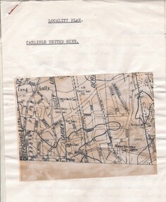
Document - CARLISLE UNITED MINE - LOCALITY PLAN
2 typed foolscap copies of notes on the Carlisle United mine on the Garden Gully Line of Reef. One has 10.5 x 14 cm map attached to the front. Notes are the same as 3501.1 notes.mine, gold, carlisle united, carlisle united mine, carlisle united mine locality plan. -
 Bendigo Historical Society Inc.
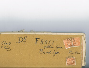
Document - MCCOLL, RANKIN AND STANISTREET COLLECTION: DR FROST, 1920
Correspondence to Dr. Frost re Badak Tin Mine. Binti Binti, Sweet Nell, Bettina, Mascotte & Maconi. Report on inspection of mine reports by Mr. M. Sheard (Mine Manager) & Dr. C. W. Laver of Kalgoorlie, map of Binti lease. Des Frost Golden Square Bendigo Victoria, charts and print.MCCOLL RANKIN & STANISTREETorganization, business, gold mining, mccoll rankin & stanistreet -
 Bendigo Historical Society Inc.
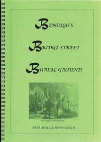
Book - BENDIGOS BRIDGE STREET BURIAL GROUND, 2010
... and maps. Book BENDIGOS BRIDGE STREET BURIAL GROUND ...Bendigo's Bridge Street Burial Ground. 53 pages in a spring bound folder containing black and white photographs and maps.Rita Hull & John Kellybendigo, history, cemetery, bendigo-history-cemetery -
 Bendigo Historical Society Inc.
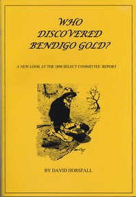
Book - WHO DISCOVERED BENDIGO GOLD, 2009
Who discovered Bendigo gold? A new look at the 1890 select committee report, 65 pages with maps and black & white photographs, published by the Australian Institute of Genealogical Studies Inc, Bendigo area.David Horsfallbendigo, history, early digging days, bendigo-history-gold discovery- henry frenchman -
 Bendigo Historical Society Inc.
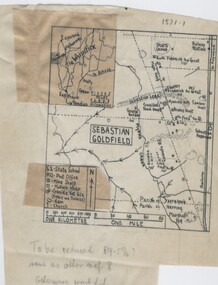
Negative - TOM PATULLO COLLECTION: SEBASTIAN GOLDFIELD
Negative,/Hand drawn of the goldfield featuring gold mine sites,cyanide vats,heaps,railway station,sports ground. A small map of the Whipstick area, and legend. Tom Patullo was formerly of Clear-Ads Bendigo.cottage, miners, sebastian goldfield, sebastian goldfield -
 Bendigo Historical Society Inc.
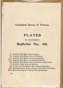
Book - MCCOLL, RANKIN AND STANISTREET COLLECTION: PLATES TO ACCOMPANY BULLETIN NO.49 MALDON GEOLOGICAL SURVEY OF VICTORIA
Book; Brown paper containers with plates (& maps) to accompany bulletin No49 of geological survey of Victoria. V Oswalds G.M. Plan of lease. VI. Oswalds G. M. Plan of workings. VII. Oswalds G. M. Transverse Sect. VIII. Oswalds G. M. Longit. Section. IX. Oswalds G. M. Plan & Sect. 500ft. Level. X. Northey's Reef plan & sections. XI. Carlisle and Whittaker's Mine Plan & Sections.XII. Goldsborough G. M. Co. Gordon's Reef, Plan & Section. XIII. Mount Tarrengower Tunnel Plan & Section.MCCOLL RANKIN & STANISTREETorganisation, industry, surveys, mccoll rankin & stanistreet -
 Bendigo Historical Society Inc.
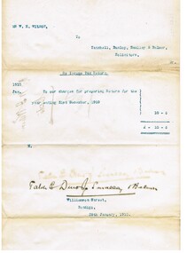
Document - CONNELLY, TATCHELL, DUNLOP COLLECTION: LEGAL PAPERS, 1890 1910
Document. Connelly, Tatchell & Dunlop - Legal Papers. 1 - 1910 - Wilson W H Re Income Tax Return. 2 - Map of Tragowel Plains Irrigation Trust, Parish of Mincha West, County of Gunbower, Portion of Allot 77. Shows channel on William Quinlan Junr block and Henry Bott on neighbouring block. 3 - 1893 - Shmick? W N? H. Notes concerning. Mentions Heffernan. 4 - Vear S. Notes concerning. 5 - Notes concerning Adair W. Mentions Goodwin, Receiver of Revenue, Inglewood. 6 - 1893 - Envelope - Returned Letters - addressed to Connelly, Tatchell & Dunlop, Bendigo. 7 - 1910 - Torn letter to Green B, Solicitor, Charlton re Beckham to McGowan.cottage, miners, connelly, tatchell & dunlop, wilson w h, tragowel plains irrigation trust, quinlan william junr, bott henry, shmick? w n?, heffernan, vear s, adair w, goodwin, green b, beckham, mcgowan -
 Bendigo Historical Society Inc.
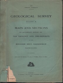
Document - MCCOLL, RANKIN AND STANISTREET COLLECTION: MAPS AND SECTIONS KALGOORLIE, 1929
Document: MCCOLL, RANKIN AND STANISTREET: green cover book Bulletin 94, Maps and Sections to accompany report on the geology and ore deposits of the Boulder Belt, Kalgoorlie. Plages IV - XV11.Government printer, Perthorganization, business, kalgoorlie, mccoll, rankin and stanistreet, kalgoorlie, maps and sections -
Bendigo Historical Society Inc.
Map - HUSTLER'S ROYAL RESERVE NO 2 CO. - LONGITUDINAL SECTION OF THE HUSTLER'S ROYAL RESERVE NO 2 CO
Longitudinal Section of the Hustler's Royal Reserve No 2 Co. on the Hustler's Line of Reef Bulletin No 33, Plate No VIII. Note - Plates 4, 8, 13, 20, 26 & 31 form a Longutudinal Section from Fortuna Hustler's to Hustler's Consols Mine. Mines mentioned are the Hustler's Royal Reserve No 2 Main Shaft, Hustler's Royal Reserve No 2 Park Shaft, Royal Hustler's, Imperial Hustler's, Great Extended Hustler's Freehold and the Great Extended. Section shows depth of levels, datum lines and height of sill above sea levelyield in ozs od gold. Geological Survey of Victoria emblem. H. Herman, Director, W. Dickson, Secretary for Mines and The Hon. J. Drysdale Brown MLC, Minister for Mines and signed by H S Whitelaw, Underground Survey Office Bendigo, September 1913. This item has not been scanned or photographed.mining, parish map, hustler's royal reserve no 2, longitudinal section of the hustler's royal reserve no 2 co, hustler's royal reserve no 2 (main shaft), hustler's royal reserve no 2 (park shaft), royal hustler's, imperial hustler's, great extended hustler's freehold, great extended, geological survey of victoria, underground survey office bendigo, h s whitelaw, h herman, w dickson, the hon j drysdale brown -
Bendigo Historical Society Inc.
Map - HUSTLER'S ROYAL RESERVE NO 2 MINE - PLAN OF THE HUSTLER'S ROYAL RESERVE NO 2 MINE
Plan of the Hustler's Royal Reserve No 2 Mine on the Hustler's Line of Reefs Bulletin No 33, Plate No VI. Boundary of Leases No 8898 and 8897 shown. Various levels shown and some geographical features. Geological Survey of Victoria emblem. H . Harman, Director, W. Dickson, Secretary for Mines and The Hon. J. Drysdale Brown, Minister of Mines and signed by H Whitdon, Underground Survey Office, Bendigo, September 1913. This item has not been scanned or photographed.mining, parish map, hustler's royal reserve no 2 mine, plan of hustler's royal reserve no 2 mine, hustler's line of reefs, geological survey of victoria, h herman, w dickson, the hon j drysdale brown mlc, h whitdon -
Bendigo Historical Society Inc.
Map - HUSTLER'S ROYAL RESERVE NO 2 MINE - PLAN OF THE HUSTLER'S ROYAL RESERVE NO 2 MINE
Plan of the Hustler's Royal Reserve No 2 Mine Bulletin No 33, Plate No V. Plan shows the Hustler's Royal Reserve No 2 (Main Shaft), Hustler's Royal Reserve No 2 (Park Shaft.), the Royal Hustler's, the Imperial Hustler's and the Extended Hustler's Freehold on the Hustler's Line of Reefs. Also mentioned is the Lightning Hill Line of Reefs. Map shows some of the levels, approximate boundary of lease and the boundary of Lease No 8892 and 8897. There are also street names and the locations of jail, lagoons, Post Office, Rosalind Park and the State School, High School and Continuation School. Geological Survey of Victoria emblem. H. Herman Director, W. Dickson, Secretary of Mines and The Hon. J. Drysdale Brown MLC, Minister of Mines. Signed by zh Whitdan, Underground Survey Office, Bendigo, September 1913.mining, parish map, hustler's royal reserve no 2 mine, plan of the hustler's royal reserve no 2 mine, hustler's royal reserve no 2 (main shaft), hustler's royal reserve no 2 (park shaft), royal hustler's, imperial hustler's, extended hustler's freehold, geological survey of victoria, h herman, w dickson, the hon j drysdale brown, h whitdan, hustler's line of reefs, lightning hill line of reefs -
Bendigo Historical Society Inc.
Map - HUSTLER'S ROYAL RESERVE NO 2 CO - TRANSVERSE SECTION OF THE HUSTLER'S ROYAL RESERVE NO 2 CO
Transverse Section of the Hustler's Royal Reserve No 2 Co Mine on the Hustler's Line of Reef Bendigo, Bulletin No 33, Plate No VII. Section shows the poppet legs and the sill of Shaft at 707.65 ft above sea level, depth of levels, stone encountered and geological features. Geological Survey of Victoria emblem. H. Herman Director, W. Dickson Secretary of Mines and The Hon. J. Drysdale Brown MLC, Minister of Mines. Signed by H S Whitelaw, Underground Survey Office Bendigo, September 1913. This item has not been scanned or photographed.mining, parish map, hustler's royal reserve no 2 co, transverse section of the hustler's royal reserve no 2 co, h s whitelaw, undergrou;nd survey office bendigo, geological survey of victoria, h herman, w dickson, the hon. j drysdale brown mlc -
Bendigo Historical Society Inc.
Map - HUSTLER'S ROYAL RESERVE NO 2 (PARK SHAFT.) - TRANSVERSE SECTION OF THE HUSTLER'S ROYAL RESERVE NO 2
Transverse section of the Hustler's Royal Reserve, No 2 (Park Shaft.) on the Hustler's Line of Reef. Bulletin No 33, Plate No IX. Section shows poppet legs and sill of shaft at 755.70 ft above sea level, depth of levels, type of stone encountered including lava and geological features. Geological Survey of Victoria emblem and beneath it H. Herman, Director, W. Dickson, Secretary of Mines and The Hon. J. Drysdale Brown MLC Minister of Mines and signed by H S Whitelaw, Underground Survey Office, Bendigo September, 1913.mining, parish map, hustler's royal reserve no 2 (park shaft.), transverse section of the hustler's royal reserve no 2 (park shaft.), h s whitelaw, underground survey office bendigo, geological survey of victoria, h herman, w dickson, the hon j drysdale brown mlc, hustler's line of reef