Showing 4555 items matching "the avenue"
-
 Phillip Island and District Historical Society Inc.
Photograph, Power station, Cowes 1930s, 1995
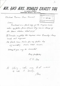
The Cowes Power station was in Cowes west, corner of Chapel Street and Osborne Avenue. James Norman Day was in charge c. 1935.HistoricalPhotocopy of letter from Mr & Mrs Ronald Day, Mermaid Beach, Queensland, sent to the Electrical Engineer, Cowes Council, 1995. and reply to sender. Also copy of photo of equipment in power station.Mr and Mrs Ronald Ernest Daypower station, electricity, james norman day -
 Phillip Island and District Historical Society Inc.
Photograph, 1920's
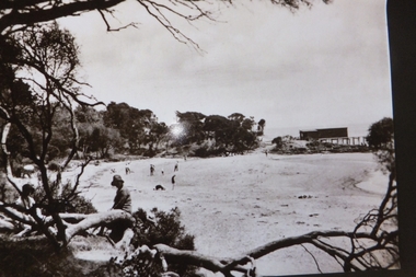
One of a group of Historical photographs purchased from Photo First Shop in Thompson Avenue, Cowes when it closed in June, 2014.Large Black & White photograph of Cowes West Beach, Mussell Rocks and the Sea Baths.Cowes Beachcowes west beach phillip island, mussell rocks cowes phillip island, cowes sea baths, photo first phillip island -
 Greensborough Historical Society
Photograph - Photograph (copy), Reid family of Hart Avenue Greensborough, 1950s
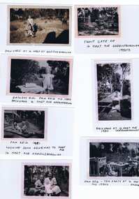
A selection of photographs of the Reid family of 16 Hart Avenue Greensborough, taken in the 1950s. Features a young Pam Reid playing in the yard.6 copies of black and white photographs with captionspam reid, reid family, hart avenue greensborough -
 Greensborough Historical Society
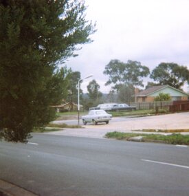
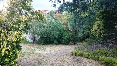
Photograph, Vacant land, Corner Wilson Avenue and Rattray Road Montmorency 1985, 1985_
A photograph of vacant land, Corner Wilson Avenue and Rattray Road Montmorency 1985, taken by Peter Graham, a Shire of Eltham Councillor.1 colour photograph.montmorency, peter graham, rattray road montmorency, wilson avenue montmorency -
 Greensborough Historical Society
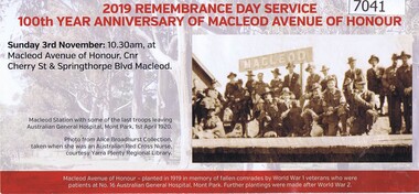
Leaflet, 2019 Rembrance Day Service: 100th anniversary of Macleod Avenue of Honour, 2019_11
The 2019 Remembrance Day Service celebrating the 100th anniversary of the Macleod Avenue of Honour, was held on 03/1102019 at Cherry Street, MacleodColour leaflet printed both sidesremembrance day 2019, cherry street macleod, macleod avenue of honour, war memorials, world war 1 -
 Greensborough Historical Society
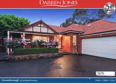
Advertising Leaflet, Darren Jones, 9a Scotland Avenue Greensborough, 16/12/2017
9a Scotland Avenue Greensborough. Three bedroom home, sold for $920,000 in December 2017. Previous sale, December 2009 for $644,000.Real estate advertising leaflet, 1 sheet, printed in colour both sides. scotland avenue greensborough -
 Greensborough Historical Society
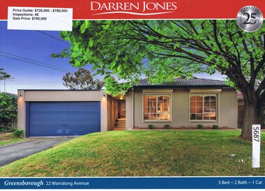
Advertising Leaflet, Darren Jones, 22 Warralong Avenue Greensborough, 02/12/2017
22 Warralong Avenue Greensborough. Three bedroom home, sold for $780,000 in February 2018. Previous sales: June 2014, $535,000.Real estate advertising leaflet, 1 sheet, printed in colour both sides. warralong avenue greensborough -
 Greensborough Historical Society
Photograph - Digital image, Marilyn Smith, Timber house Greensborough, 04/01/2016
Timber house, Greensborough, January 2016. The house is located at 14 Poulter Avenue, former residence of the Leaford Family in the 1930/1940s.Digital copy of colour photographhouses in greensborough -
 Friends of Ballarat Botanical Gardens History Group
Work on paper - Research and Talk by Roy D, Mosman, FBBG. 24/2/2000, The Life and Work of Tilly Thomson, 24/2/2000
Mrs Thompson was highly regarded and well-known for her work especially at E.Lucas and Co. and with Ballarat's Avenue of honour and the Arch of Victory.Mrs Thompson's contributions to the Ballarat community were significant in terms of her humanity and business acumen.4 typed pages headed "The Life and Work of Tilly Thompson".These 4 pages all have retyped written at the top of the page in black biro. This draft has been edited with some amendments throughout.john garner, doctor john garner, friends of ballarat botanical gardens, e.lucas and co., avenue of honour, arch of victory, "the golden threads", matilda louise clennell, matilda louise thompson., john garner collection, gardens, ballarat -
 Hymettus Cottage & Garden Ballaratnon-fictionavenues of honour, war, war memorials
 -
 Stawell Historical Society Inc
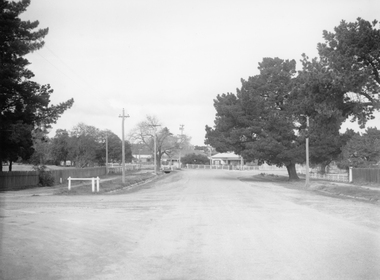
Photograph, Clifton Avenue looking towards Barnes Street
Street Scene Clifton Avenue Stawell looking towards Barnes Street. Photo taken before the pine tree were removed.Black and white photograph of a wide street with trees lining the street, houses in the background.stawell -
 Chelsea & District Historical Society Inc
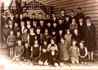
Photograph - Chelsea State School, Students at Kismet Hall, Chelsea, 1925
Chelsea State School was built on Argyle Avenue and officially opened on 27 January 1915. Kismet Hall was located in The Strand, Chelsea.Sepia photo of students of Chelsea State School, in front of Kismet Hall. The teacher is Miss Cooper. chelsea, education, chelsea primary school, school, chelsea state school, kismet hall -
 Greensborough Historical Society
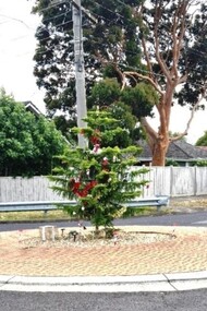
Photograph - Photograph - Digital Image, Marilyn Smith, Christmas in Greensborough 2020, 23/12/2019
Digital image of a decorated Christmas tree on the traffic roundabout at the corner of Nepean Street and Sainsbury Avenue Greensborough, 23/12/2020Part of a collection of miscellaneous historical images with a connection to the local area.Digital colour photograph of Christmas treechristmas, nepean street greensborough, sainsbury avenue greensborough -
 Phillip Island and District Historical Society Inc.
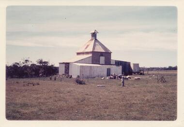
Photograph, 1960's
Donated by N.M. & J.D. Archibald, 1973 April.Chicory Kiln in Cowes, Thompson Avenue, Mr. F. T. Morgan-Payler. Built for Mr. Gordon West, 1943, of poured cement. Mesh floor 14' x 15' - capacity one ton per floor. Still in operation as at 1973.local history, photography, photographs, agriculture, chicory industry buildings, historic, chicory kiln, chicory industry, coloured photograph, cowes, phillip island, n & j archibald -
 Ringwood and District Historical Society
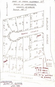
Map, Subdivision Plan - Adam Court area, North Ringwood, Vic. - circa 1960s
Single page plan printed showing allotments included in un-named subdivision layout surrounding Adam Court, Ringwood North. Subdivision includes Adam Court, Burlock Avenue, and Felix Crescent. Sold allotmenets marked in red, with price notations.Page heading - Part of Crown Allotment 27B Parish of Warrandyte County of Evelyn Scale 60'-1". Rubber stamp imprint and handwritten address at bottom of page - "Binburra Estates Pty. Ltd. 23 Pitt St., Ringwood, 870-1184". -
 Bendigo Historical Society Inc.
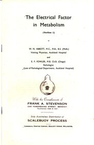
Document - BILL ASHMAN COLLECTION: W.N.ABBOTT MEDICAL RESEARCH PAPER
9 copies of a Medical research paper The Electrical Factor in Metabolism (Section 1) written by W.N.Abbott and E.F.Fowler with reference to Scalebuoys, printed by Commercial Printing Company Boulcott Avenue Wellington, distributed with the compliments of Frank A Stevenson 244 Hargreaves Street Bendigo.medical -
 Hume City Civic Collection
Photograph, early 1980s
The photograph shows the extent of Sunbury's development to the west of the town in the early 1980s. The settlement at this stage extended along either side of Gap Road for about 0.5 km beyond Elizabeth Drive.A coloured landscape photograph with rounded corners taken from Mt. Holden and looking towards the expanding town of Sunbury. The Melba Avenue drain which flows into Blind Creek is in the foreground. Sheoak Hill, the site of the former Sunbury Asylum is in the middle of the skyline.sunbury township, reservoir road, mt. holden, sunbury asylum, george evans collection -
 Kew Historical Society Inc
Plan - Subdivision Plan, Churchill Park Estate, Templestowe
Historic subdivision plan of the Churchill Park Estate in Templestowe.Undated subdivision plan advertising the Churchill Park Estate inTemplestowe. Streets identified in the plan include: Corroboree Place, Astley Street, Jeffrey Street, Airds Road, Dove Court, Potter Court, Thompsons Road, Richards Street, and Birchwood Avenue.Annotations in ink on the plan by agentsubdivision plans - templestowe (vic), churchill park estate - templestowe (vic) -
![Studley House, Nolan Avenue [Kew]](/media/collectors/550653872162f11fb04854aa/items/658f97ed9239cf6fd437726e/item-media/658f97f89239cf6fd43772b6/item-fit-380x285.jpg) Kew Historical Society Inc
Kew Historical Society IncPhotograph - Studley House, Nolan Avenue [Kew]
The first section of Studley House, now part of the preparatory school for Xavier College conducted by the Society of Jesus in Kew, was built in about 1857 for Parliamentarian John Hodgson, an early settler in the district, as a two-storey residence in the Classical Revival style. The name Studley House was first recorded in the Kew ratebooks in 1862, after the house was purchased in 1860 by James McEvoy, squatter. Alterations and an extension, designed by William J Ellis were undertaken in 1875. The house was again altered in 1919 during the ownership of John Wren, former bookmaker, ALP lobbyist, influential Irish-Catholic and millionaire. After 1969 the house was used by the school. (Victorian Heritage Database, 2023)This work forms part of the collection assembled by the historian Dorothy Rogers (1905-1973), donated to the Kew Historical Society by her son in 2015. The manuscripts, photographs, maps, and documents were sourced by her from both family and local collections or produced as references for her print publications. Many were directly used by Rogers in writing ‘Lovely Old Homes of Kew’ (1961) and 'A History of Kew' (1973), or the numerous articles on local history that she produced for suburban newspapers. Most of the photographs in the collection include detailed annotations in her hand. The Rogers Collection provides a comprehensive insight into the working habits of a historian from the 1960s to the 1970s. Original monochrome photograph of architectural elements used in the decorative scheme on the exterior of Studley House in Nolan Avenue, Kew. The POV is of the rendered and painted Doric columns forming the ground floor colonnade. Note the Victorian tessellated tiles used on the floor of the verandah.dorothy rogers, studley house -- nolan avenue (kew), xavier preparatory school -
![Studley House, Nolan Avenue [Kew]](/media/collectors/550653872162f11fb04854aa/items/658f985b9239cf6fd43773ba/item-media/658f987a9239cf6fd4377424/item-fit-380x285.jpg) Kew Historical Society Inc
Kew Historical Society IncPhotograph - Studley House, Nolan Avenue [Kew]
The first section of Studley House, now part of the preparatory school for Xavier College conducted by the Society of Jesus in Kew, was built in about 1857 for Parliamentarian John Hodgson, an early settler in the district, as a two-storey residence in the Classical Revival style. The name Studley House was first recorded in the Kew ratebooks in 1862, after the house was purchased in 1860 by James McEvoy, squatter. Alterations and an extension, designed by William J Ellis were undertaken in 1875. The house was again altered in 1919 during the ownership of John Wren, former bookmaker, ALP lobbyist, influential Irish-Catholic and millionaire. After 1969 the house was used by the school. (Victorian Heritage Database, 2023)This work forms part of the collection assembled by the historian Dorothy Rogers (1905-1973), donated to the Kew Historical Society by her son in 2015. The manuscripts, photographs, maps, and documents were sourced by her from both family and local collections or produced as references for her print publications. Many were directly used by Rogers in writing ‘Lovely Old Homes of Kew’ (1961) and 'A History of Kew' (1973), or the numerous articles on local history that she produced for suburban newspapers. Most of the photographs in the collection include detailed annotations in her hand. The Rogers Collection provides a comprehensive insight into the working habits of a historian from the 1960s to the 1970s. Original monochrome photograph of architectural elements used in the decorative scheme on the exterior of Studley House in Nolan Avenue, Kew. The POV is of the two storey rendered and painted colonnade featuring Doric columns o the ground floor and Ionic columns on the first floor.dorothy rogers, studley house -- nolan avenue (kew), xavier preparatory school -
 8th/13th Victorian Mounted Rifles Regimental Collection
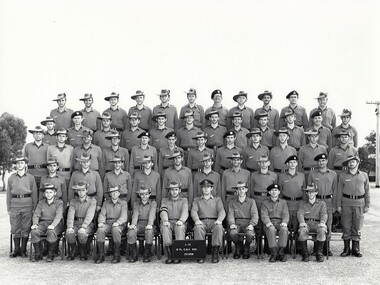
Photograph - Recruit Course at Wangaratta
Soldiers were recruited by regimental efforts. Recruit training was carried out under Brigade control.Black and white photograph of a rows of soldiers at the 3/73 CMF Recruit Course. Several soldiers of 8/13 Victorian Mounted Rifles are identified by their headgear and badges. Course appears to have been held at Beersheba Barracks Sisely Avenue Wangaratta.recruit, wangaratta, beersheba barracks, nulla -
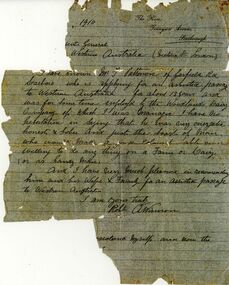 Bendigo Historical Society Inc.
Document - ETHEL PATTISON COLLECTION: ASSISTED PASSAGE DOCUMENT, 1910
Woodlands Dairy Co manager testimonial, handwritten letter on pale blue paper. On top Rh corner ' The Rise, Tennyson Avenue, Scarborough' letter signed by A. Winson, supporting Mr. F. Pattison ( Patterson ) application for a supported passage to Western Australia.fred pattison, assisted passage, western australia, migration -
 Ringwood and District Historical Society
Document - Research Notes, Richard Carter, Land Subdivisions in Ringwood 1890-1950
Handwritten table listing main local pre-1950s subdivisions in the Ringwood area, with estate names, streets, number of allotments for sale, and where known, vendor agent, LP (Lodged Plan) title registration number, and auction/sale date, some with sale price.Pg1 RINGWOOD STATION ESTATE LP3070 (Year?) Station Street, William Street (now Kendall Street), Wantirna Road, Station Street Pg1 RINGWOOD TOWNSHIP ESTATE LP5577 (1913) Station Road (now Warrandyte Road), Pratt Street (part now Aird Street), Whitehorse Road Pg2 RINGWOOD ORCHARD ESTATE LP4315 (1914) Brysons Road, Hillcrest Road, Anzac Avenue, Sulva Road Pg3 RINGWOOD RAILWAY ESTATE LP7522 (1918) Whitehorse Road (now Mount Dandenong Road), Dublin Road, Freeman Street, Patterson Street, Bona Street Pg4 THE RINGWOOD ESTATE LP7578 (1919) Warrandyte Road, Hobart Street, Paxton Street, Arnold Street Pg5 GARDEN FARMS ESTATE (LP?) (1919) Canterbury Road, Armstrong Road, Bungalook Road, Orchard Road, Bayswater Road (now Mountain Highway) Pg6 THE RINGWOOD ESTATE (SECOND SUB-DIVISION) LP7604 (1919) Warrandyte Road, Tamar Street, Derwent Street, Mersey Street Pg7 RINGWOOD STATION ESTATE LP7703 (1919) Bedford Road, Williams Grove (now Lena Grove) Pg8 RINGWOOD TOWNSHIP ESTATE LP8198 (1919) Wantirna Road, Ellison Street, Haig Street, Greenwood Avenue Pg9 EASTFIELD ESTATE (LP?) (1920) Eastfield Road, Longview Road, Pleasant Rise, The Mount Pg10 ELECTRIC RAILWAY ESTATE RINGWOOD LP9473 (1922) Campbell Street, Myrtle Avenue, George Street (now Tudor Court), Henry Street (now Myrtle Avenue), Williams Grove (now Lena Grove) Pg11 RINGWOOD PARK ESTATE LP7884 (1922 - two stages) Wonga Road (now Loughnan Road), William Street, Andrew Street, Harrison Street Pg12 HEATHMONT STATION ESTATE LP11009 (Date? - after 1922) Lisgoold Street, Viviani Crescent, Balrour Avenue, Station Street (now part Heathmont Road and part Wainui Street) Pg13 RINGWOOD RAILWAY ESTATE LP10507 (1923) Whitehorse Road, Sherbrooke Avenue, Burwood Avenue, Bonview Avenue, Heatherbrae Avenue, Grant Crescent Pg14 GARDEN HOMES ESTATE (LP?) (1923) Mullum Road, The Centreway, Wattle Crescent (now Wattle Avenue) Reserve Crescent (now Reserve Road) Pg15 DUBLIN ROAD ESTATE LP11993 (1923) Alexandra Road, Vonadawn Avenue, Green Street, Wood Street, Howard Avenue, Bedford Road, Dublin Road Pg16 CARLINGA ESTATE RINGWOOD LP9620 (1923) Bourke Street, Bond Street, Ringwood Street Pg17 PRATT'S JUNCTION ESTATE (LP?) (1923) Junction Street, Georges Road, Oliver Street, Whitehorse Road Pg18 EAST RINGWOOD ESTATE LP10492 (1923) Bona Street, Patterson Street, Miller Grove, Fairview Avenue, Eastfield Road, Whitehorse Road (now Mount Dandenong Road) Pg19 COLEMAN'S HEATHMONT ESTATE LP9974 (1923) Canterbury Road, Bedford Road, Alvena Crescent, Coleman Street, Leonard Street (now Royal Avenue) Pg20 RINGWOOD HEIGHTS ESTATE LP10506 (1924) Whitehorse Road, Bonview Avenue, Grant Crescent, Hillcrest Avenue, Heatherbrae Avenue, Margaret Street, Mary Street Pg21 EAST RINGWOOD STATION ESTATE LP10551 (1924) Knaith Road, Wenwood Street, Lois Street, Victoria Street, Station Street (now Railway Avenue) Pg22 GRAND VIEW ESTATE LP11019 (1924) Whitehorse Road, Rupert Street, Herbert Street, Leonard Street Pg23 RINGWOOD RAILWAY ESTATE & RINGWOOD HEIGHTS ESTATE - FINAL SECTIONS LP10506 & LP10507 (1924) Whitehorse Road, Sherbrooke Avenue, Burwood Avenue, Bonview Avenue, Heatherbrae Avenue, Margaret Street, Mary Street, Grant Crescent Pg24 RINGWOOD EAST ELECTRIC STATION ESTATE (LP?) (1924) Railway Parade (now Patterrson Street), Federal Road, Howship Avenue (part now French Street), Dublin Road, Rosedale Crescent Pg25 BEDFORD PARK (now Ringwood Secondary College) (LP?) (1924) Bedford Road, Adams Street, Anderson Street, Joyce Street, Graham Road Pg26 CROWN JEWEL ESTATE LP11645 (Private sales after 1924) Mount Dandenong Road, Mirabel Avenue, Valda Avenue, Evon Avenue, Velma Grove Pg27 GRAND CENTRAL ESTATE LP10917 (1925) Heathmont Road, Great Ryrie Street, Douglas Street, Garden Street, Bellevue Avenue Pg28 RINGWOOD (unnamed estate - 1926) Nelson Street, Seymour Street, Whitehorse Road Pg29 EAST RINGWOOD RAILWAY STATION ESTATE (YEAR? - 25 shops 60 villas) Railway Avenue, Dublin Road, Lawrence Grove, Stanley Avenue, Knaith Road Pg30 CHARM VIEW ESTATE (LP?) (year? - after 1926) Canterbury Road, Heathmont Road, Dickasons Road, Bennjett Avenue, Orchid Street Pg31 SUNBEAM ESTATE LP12150 (Circa 1925) Govt Road (now Old Lilydale Road), Sunbeam Avenue, Holland Road, Everard Street (now Everard Road) Pg32 FAIRVIEW ESTATE EAST RINGWOOD LP10853 (Circa 1924) Eastfield Road, Patterson Street, Margaret Street (now Short Street) Pg33 EAST RINGWOOD TOWNSHIP ESTATE LP3025 (Circa 1924 - 35 allotments) Mount Dandenong Road, Grey Street, Eastfield Road Pg34 EAST RINGWOOD TOWNSHIP ESTATE LP3025 (Circa 1924 - 49 allotments) and STATE SCHOOL ESTATE (26 allotments) and EAST RINGWOOD STATION ESTATE (14 shop sites) Mount Dandenong Road, Grety Street, Dunn Street, Eastfield Road, King Street, Holland Road, Dublin Road, Patterson Street, Bona Street Pg35 EAST RINGWOOD CENTRAL ESTATE LP17004 (1948) Knaith Road, Shasta Avenue, Talofa Avenue, Russet Road, Dublin Road Pg36 WARE ESTATE LP43360 (1958) Ware Crescent, Davey Drive, Grey Road (now Grey Street), Mount Dandenong Road Pg37 Lot 57 Kendall Street LP3070 (1939) £75.0.0 Pg37 Lot 14 LP7346 (year?) £225 Pg37 Lot 8 WHITE HORSE ESTATE LP14010 (year?) Maroondah Hwy, Seymour Street £98.9.0 Pg37 Lots 4-14 incl. LP10902 (year?) £300 Pg37 Lots 69&70 LP2216 (1939) Bedford Road, Pitt Street £500 Pg37 Lots 60&70 LP2216 (year?) £460 Pg37 MOUNTAIN VIEW ESTATE LP10902 (1936) Lots 1&2, 19-22 Wantirna Road, Daisy Street £50 Pg38 RAILWAY STATION ESTATE RINGWOOD EAST LP7522 (1925) Lots 16 to 19 £250 Pg38 RINGWOOD PARK ESTATE (LP?) (1924) Lot 112 Munro Street £230 Pg38 RINGWOOD TOWNSHIP ESTATE (LP?) (1925) Lot 57 Wantirna Road £850 Pg38 ELECTRIC RAILWAY ESTATE LP9473 (1925) Lot 98 & 99 £180 (30/- foot) Pg38 ELECTRIC RAILWAY ESTATE LP9473 (year?) Lot 100 £233.12.6 incl improvements (£2.12.6 foot) Pg38 Lot 22&23 Bedford Road Heathmont (LP & year?) £675 incl improvements Pg39 Lot 9 Mullum Mullum Road LP8221 (1923) £150 Pg39 Lot 27 Haig Street LP8198 (1925) £825 Pg39 Lot 56 Haig Street cnr Wantirna Road LP8198 (1923) £171 Pg39 Lots 3 & 4 Loughnan Road LP9626 (192?) £147 Pg39 Lots 98 & 99 Myrtle Avenue LP9473 (1925) £180 Pg39 Lots 80 & 81 Myrtle Avenue LP9473 (1929) £150 Pg39 Lot 30 Sherbrooke Avenue LP10507 (1926) £700 incl improvements Pg40 Lot 10 (year?) LP7703 £750 Pg40 Lot 36 (year?) LP7522 £25 Pg40 Lot 38 Pitt Street LP2216 (year?) £350 Pg40 Lot 7 Dublin Road cnr Green Street LP11993 (year?) £300 -
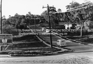 Eltham District Historical Society Inc
Photograph, R.J. Manuell, Sherbourne Rise, Briar Hill, c.1964
Sherbourne Rise Estate, looking up Woodland Grove from Calrossie Avenue, Briar Hill. The house is believed to be No. 8. This is prior to Regal Court being established off Woodland Grove. View of Squires land which was subdivided for housing - two parts Woodland Crest higher part off Woodland Grove and Calrossi Avenue, Briar Hill showing new roads with curb and channelling and footpaths. No date.Black and white photograph printed with white bordersVerso: COO2briar hill, real estate, woodland grove, squires, roads, sherbourne rise estate -
 Ringwood and District Historical Society
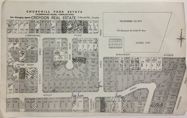
Flyer, Land Sale Brochure, Heathmont Estate, Vic. - circa 1960
Advertisement for sale of residential lots - Heathmont Estate, opposite Heathmont Railway Station, with map and locality plan.Subdivision includes Canterbury Road, Royal Avenue, Coleman Street, Stoda Street, Herman Street, and Campbell Street. Agent - A.W. Dickson, opposite Station, Ringwood. Phone WU6007. -
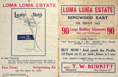 Ringwood and District Historical Society
Flyer, Land Sale Brochure, Loma Loma Estate, Ringwood East, Vic. - circa 1924
Flyer includes extract from "The Sun" 30/10/1924. "Ringwood has been created a Borough with capital value of £680,000. In 1908 there were 173 houses, 8 shops and 720 people. In 1918 the respective figures were 520, 45 and 2,080. For twelve months ended June, 1924, £51,000 worth of Home Sites were sold and £26,000 worth of new buildings were erected. Outward (train) passenger journeys have increased from 94,000 in 1919 to 182,000 in 1923. Train services have been almost doubled and time to Melbourne reduced from 60 to 37 minutes."Bi-fold double-sided land sale advertisement for Loma Loma Estate, Ringwood East, including area map, layout of the estate, and summary of local facilities and services.Subdivision includes Loma Street, Highton Street, Morinda Street, and Station Street (later Railway Avenue) Ringwood East. Agent: T.W. Burkitt, Ringwood, Phone Ringwood 157. -
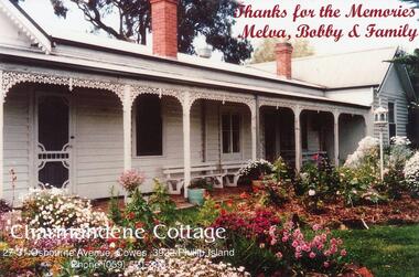 Phillip Island and District Historical Society Inc.
Photograph, Charmandene, 1989
One of 9 photographs donated by Mrs Champion.Coloured photograph of Charmandene Cottage."Thanks for the Memories. Melva, Bobby & Family. Charmandene Cottage, 27 - 31 Osbourne Avenue, Cowes, 3922 Phillip Island. Phone (059) 521 386" On back: "Melva Smith"charmandene cowes phillip island, charmandene cottage, cowes phillip island, melva smith, mrs champion -
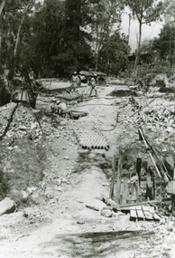 Ringwood and District Historical Society
Photographs, 1979-80 MMBW pipe line project at Hubbard Reserve, North Ringwood � Tunnel shafts
Part of a 43-photo record of the MMBW�s engineering feat in drilling a 12 inch pipe line up to 40 feet deep through rock hardened by volcanic action associated with geological fault that occurs along the line. The work took place from October 1979 to May 1980 on the southern boundary of Hubbard Reserve, North Ringwood. The collection was presented to the Ringwood Historical Research Group by J Clarke on 9th June 1980.E561 N12 Feb 1980 A43 Line of tunnel shafts at 29-30 Burlock Avenue showing swivel cranes 5 and 6 from the bore-hole in Lot 7 -
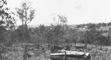 Ringwood and District Historical Society
Photograph, View from Herman Pump's orchard, Heathmont near Royal Avenue. Looking towards Bedford Rd. and Ringwood (undated)
Typed below photograph, "View from Herman Pump's orchard, Heathmont near Royal Avenue. Looking towards Bedford Rd. and Ringwood. Loughnans Hill in background to left of centre." -
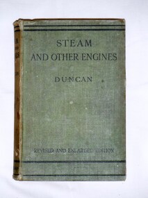 Bay Steamers Maritime Museum
Book, J. Duncan, Steam and Other Engines, 1932
Green cloth hard cover book of 537 pagesFirst page, handwritten in pencil "9/6 / William Jack T?leve / 45 Grand Avenue / Rose Park" Back cover homework instructions in same handwritting in pencilnon-fiction, engineering, steam, science, heat engines, engines, mechanics