Showing 3661 items
matching track
-
 Marysville & District Historical Society
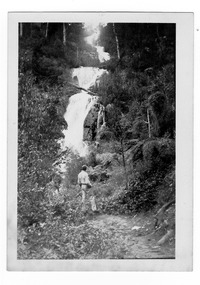
Photograph (item) - Black and white photograph, 1947
A black and white photograph of Steavenson Falls in Marysville in Victoria.A black and white photograph of Steavenson Falls in Marysville in Victoria. The Steavenson Falls is named after the Victorian Assistant Commissioner of Roads & Bridges, John Steavenson who arrived in Victoria in the early 1860's.Stevens Falls. Marysvi/ -lle. Oct.47. 39stevens falls, steavenson falls, marysville, victoria, waterfalls, photograph, john steavenson -
 Halls Gap & Grampians Historical Society
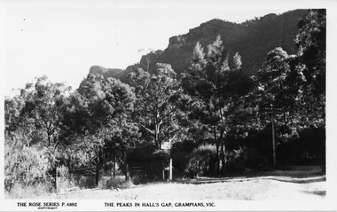
Postcard - B/W
No. P4892 in the "Rose Series" of postcards. For information on Grampian House, refer to "Victoria's Wonderland" pp. 69-75. For information on the Wonderland Range refer to pp.41, 70, 73, 77, 84, 145-146 of "Victoria's Wonderland".Photo of the entrance to Grampian House. There is a grass are and a wire fence in the foreground. A track leads back into a bush area , there is a sign saying "Grampian House" attached to a tree. The peaks of a rocky range (the Wonderland Range) are visible behind.accommodation, guesthouses, scenery, wonderland range -
 4th/19th Prince of Wales's Light Horse Regiment Unit History Room
Newspaper - Newspaper cutting, Honoring (sic) the men of the 4th Light Horse, 1990
A clipping from a newspaper that is a reply to an article on the Light Horse . The reply refers to the 4th Light Horse Memorial Association, the 4/19 PWLH and Dr David Holloway's book, 'Hooves, Wheels and Tracks', the history of the Regiment4 light horse memorial association, history of 4th alh -
 Bendigo Historical Society Inc.
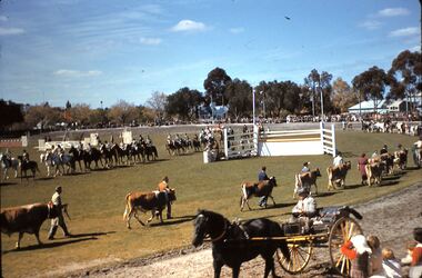
Slide - FLEMING COLLECTION: 1950S BENDIGO SLIDE, 1950s
Bendigo 1950s. Bendigo Easter Procession. Easter Monday was 7 April 1958. View of the Bendigo Show Grounds (now Tom Flood Centre). Horses and cattle parading around the ring, horse and gig on the track.Kodachromeevent, easter fair, bendigo easter fair, bendigo 1950s. bendigo easter procession. easter monday was 7 april 1958. view of the bendigo show grounds (now tom flood centre). horses cattle parading ring, horse gig track -
 Bendigo Historical Society Inc.
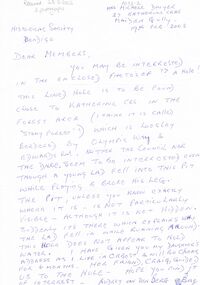
Document - DWYER COLLECTION: LETTER RE STONE WELL LOCATION
Handwritten letter, blue biro on white paper, describing stone well, Biffins Track, Maiden Gully. Letter is from Mrs. Michele Dwyer, 27 Katherine Cres., Maiden gully, 19th. Feb. 2003.bendigo, buildings, stone well letter -
 Bendigo Historical Society Inc.
Photograph - UNKNOWN FAMILY COLLECTION: PHOTOGRAPH
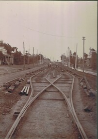
Photograph - black and white. Tram tracks being laid, could be Eaglehawk Road. Shop on left says ANDERSON CASH STORE. Written on back, Peter Brisbane, Room 4, 18 Churchill Avenue, Bendigo.W.H. Robinson, Mundy Street, Bendigo.place, transport, tram, tram track being laid. anderson cash store. -
 National Vietnam Veterans Museum (NVVM)
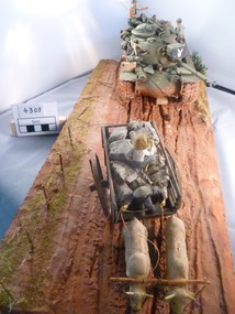
Model - Diorama, US Army Tank and Farmers Cart
Muddy track depicting army tank following farmer's two wheeled loaded cartpulled by two oxen. Tank gun shield bears playboy bunny logo. US plag flies from rear of tank.us army, tank, diorama -
 Bendigo Historical Society Inc.
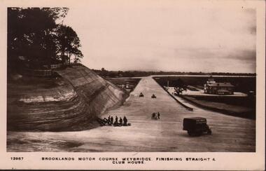
Postcard - BASIL WATSON COLLECTION: BROOKLANDS MOTOR COURSE WEYBRIDGE UK
Black and white postcard. On bottom of card: 'Brooklands Motor Course, Weybridge, finishing straight and club house' Image shows race track in centre of photo, men on LH side, covered truck on RH side.Kingsway Real Photo Seriesplace, sport, brooklands motor course -
 Bendigo Historical Society Inc.
Slide - BENDIGO VIEWS, Jan 1970
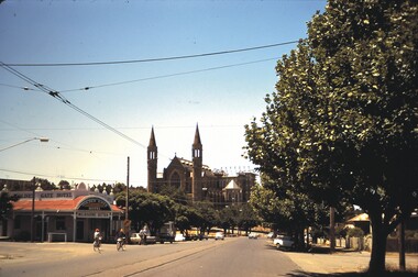
Slide. Bendigo Views. High St., Bendigo with view of the Cathedral and the Golden Gate Hotel on the corner with the rounded veranda. Some people riding bikes and some cars on the street. Also the tram tracks and their overhead wires.slide, bendigo, bendigo views, bendigo views -
Whitehorse Historical Society Inc.
Document, Mini Fun Olympics, 1/05/1988 12:00:00 AM
Poster to advertise 'Mini Fun Olympics' to be held on Sunday 1 May 1988 from 11 am to 5 pm at the Bill Sewart Athletic Track, East Burwood Reserve, Burwood Highway, East Burwood.Poster to advertise 'Mini Fun Olympics' to be held on Sunday 1 May 1988 from 11 am to 5 pm at the Bill Sewart Athletic Track, East Burwood Reserve, Burwood Highway, East Burwood.Poster to advertise 'Mini Fun Olympics' to be held on Sunday 1 May 1988 from 11 am to 5 pm at the Bill Sewart Athletic Track, East Burwood Reserve, Burwood Highway, East Burwood.city of nunawading. parks and recreation department, sports and recreations, bill sewart athletic track, east burwood reserve -
Whitehorse Historical Society Inc.
Article, Vermont's heart / Old bell
The historic former Vermont Primary School destroyed by fire. Includes poem by Vermont historian Tim Shambrook. Mayor of Nunawading, Cr Savvas Athan wants to track down the original bell from the old school.primary schools, vermont primary school, no. 1022, shambrook, tim, athan, savvas -
 Whitehorse Historical Society Inc.
Photograph - Coloured photograph, Blackburn Railway Station, 2/08/1979 12:00:00 AM
Coloured photo of Blackburn Railway Station. A third track is being laid to cope with the station being used as a terminus while reconstruction work is carried out at Box Hill railway station. Photo looking east.blackburn railway station, blackburn -
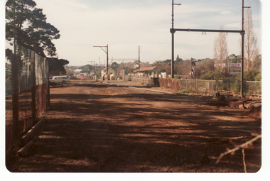
 Whitehorse Historical Society Inc.
Photograph, Railway tracks looking west, 1/06/2009
One of a collection of photographs taken of the Nunawading Railway Station prior to the lowering of the railway line and building of the new railway station on the western side of Springvale Road so that the Springvale Road Rail Crossing can be eliminated.Black & white photograph of he precinct surrounding the Nunawading Station and the Springvale Road Railway crossing. This photograph is the railway crossing and tracks looking west to Blackburn. See NP 3545 to NP3567 for the complete set of photographsnunawading railway station, springvale road nunawading, redevelopment of railway line/springvale road. -
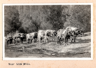 Southern Sherbrooke Historical Society Inc.
Photograph, Near Saw Mill
Ten or more cattle pulling logs to a sawmill (possibly McLaren's sawmill in Belgrave). The land around the track is cleared and it is heavily treed in the background. There is dead timber lying around and the land looks dry. c.1920. -
 Ballarat Tramway Museum
Photograph - Colour Photograph/s, Warren Doubleday, 1/10/1993 12:00:00 AM
Colour photograph taken of BTM no. 26 running out into Wendouree Parade from the depot access track - October 1993, through the window of another tramcar. Looking south along Wendouree Parade. On Fujicolor paper.Initials of "WAD" on rear in ink.btm, wendouree parade, tram 26 -
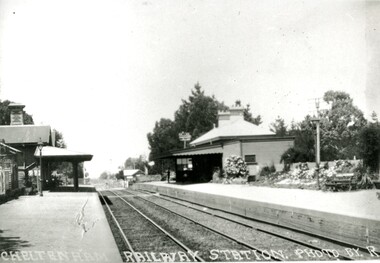 City of Kingston
Photograph - Black and white, Percy Fairlam, c. 1920
Cheltenham station was built in 1898 and serviced a primarily rural, market gardening community.The late 1870s saw the beginning of a massive program to construct railway lines throughout Victoria. One of these lines was from Caulfield to Frankston. A survey undertaken by J P Madden, an engineer employed by the railways, established the route, although this was later modified. At the time of the official opening of the line to Mordialloc no station buildings had been constructed despite the fact that tenders had been called in the Government Gazette of 26 May 1881 and subsequently in the Argus newspaper on 30 August 1881 for what became stations at Glenhuntly, Ormond, Bentleigh, Moorabbin, Highett, Cheltenham, Mentone and Mordialloc. However platforms and sidings were completed, ready to receive passengers. Cheltenham station opened in 1898.Black and white photograph of Cheltenham Railway Station with the two platforms separated by two sets of tracks. Each platform has a station house on it, and the one on the right hand side also has a garden and park bench.Handwritten in red ink on reverse: A7 / 75%cheltenham, trains, railway, railway station, railway crossing, suburbs -
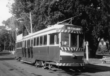 Ballarat Tramway Museum
Photograph - Black & White Photograph/s - set of 2, Bob Lilburn, c1970
Black and white photograph of Ballarat tram No. 37 at Gardens terminus, standing on the loop track at the terminus. Tram has destination of "City" and SEC Roof advertisement "Everything's under control in my all electric kitchen." trams, tramways, gardens, gardens loop, wendouree parade, tram 37 -
Vision Australia
Object, Clarke & Smith, Clarke & Smith Talking Book Player cartridge, 1960s
A cartridge designed to be played on the Clarke & Smith MK1 Talking Book player. Each cartridge houses the complete mechanism, track change linkages, replay heads and tape spools, which are stacked on top of each other within the housing. When one track was finished, the user was required to lift the metal cassette, turn it over, and replace it on the turntable. The bulky cartridges were distributed by post or train in strong 'Globite' cases made with reinforced corners and strapped. Metal cartridge covering magnetic tape spool The Doves of Venusaudio equipment, clarke and smith -
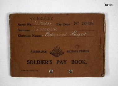 Bendigo Military Museum
Book - BOOK, SOLDIERS PAY, 3) Australian Military Forces
Pay book issued to Edmond Paget Seymour VX 102658, Serving in Australian Army during WW2. Tracking pay details, next of kin, medical and training.Pay book for Australian Soldier No. 264394. Cover brown. Coat of Arms and Australian Military Forces. 26 pages inside. Rear cover has 2 photos of soldier stapled in. Records inside cover from 15/5/41 to 25/6/43. All pages stamped with "Discharge" in purple. Two small holes punched through bottom of the book 3cm apart.Pages stamped in purple "Discharge". Front cover VX102658, "Edmond Paget Seymour".passchendaele barracks trust, soldiers pay book, e. p. seymour -
 Eltham District Historical Society Inc
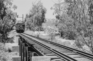
Photograph, George Coop, Single Motor Carriage (Red Rattler) Tait train heading for Hurstbridge about to cross over the Diamond Creek just north of Allendale Road, c.December 1980, 1980
The derailment guard rail is intended to prevent severe derailment and to keep errant trains in line with track when going over culverts or similar should they become derailed.Digital TIFF file Scan of 35mm Ilford FP4 black and white transparency471m, allendale road, derailment guard rail, diamond creek, hurstbridge line, railway bridge, red rattler, red rattler single carriage, single motor carriage, tait train -
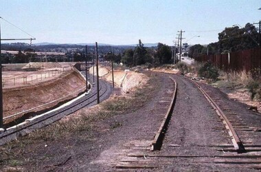 Greensborough Historical Society
Photograph - Digital Image, Watsonia Station, 1978c, 1978c
Watsonia Station during the duplication of the train line c1978. This photograph shows the existing rail line and the construction of the new tracks in the cutting. Looking toward Grimshaw Street.Shows the rural nature of the Greensborough area in the early 20th centuryDigital copy of colour photograph. trains, watsonia railway station -
Tatura Irrigation & Wartime Camps Museum
Photograph, D. Walker photographer, Hogan Street Tatura 1987, 1987
Photograph of Hogan Street, Tatura, looking west. 1987. Clock Tower, monument to Dr. J. Park, in foreground. Railway tracks and crossing lights also in pictureBlack and white photograph of Hogan Street, Tatura looking west. Part of supermarket and Criterion Hotel at left. Street lights, traffic signs, cars.on back: Hogan Street looking west. Clock tower 1987hogan street tatura -
Lakes Entrance Regional Historical Society (operating as Lakes Entrance History Centre & Museum)
Photograph, 1930 c
Oil water emulsion was fed into concrete vats where up to 95 percent of water was drained off plant situated at end of track to Midwest No 1 boreBlack and white photograph showing the dehydrationplant which separated the oil from original emulsion sityuated in the gully east of Capes Road off Myer Street Lakes Entrance Victoriaoil and gas industry -
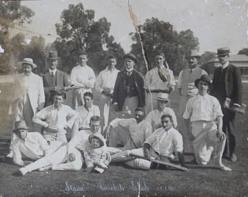 Stawell Historical Society Inc
Photograph, Stawell Cricket Club 1913
Cricket Stawell Club 1913. Taken at Central Park with Curators Cottage in background. There is a granite sand bike track outside the grass oval inside a picket fence.B/W Photo: with 16 People in three rows, Back Row Standing, centre row seated, front row laying down man on right is wearing cricket pads and has a bat over one leg, the man on the right has a young child in front of him. 8 of th emen are wearing hats.Stawell Cricket Club 27.1.13stawell sport -
 Vision Australia
Photograph - Image, Foto Group, 2008 Tandem Cycling event, 13/2/2008
On February 13, 2008 a tandem cycling event was held at Kooyong. Riding around the blind cricket oval, then along the Gardiner's Creek bike track beside the freeway.19 digital images of tandem cycling event at Kooyongvision australia, recreation, owen d'costa, kate gniel -
 Ballarat Tramway Museum
Photograph - Trams 34 and MTT 1 at AETM St Kilda SA, c1975
The photograph show SEC Ballarat tram No. 34 and Adelaide MTT No 1 on the AETM St Kilda Adelaide tramway museum track c1975. Photo and date unknown.Yields information about tram 34 at AETM Adelaide in 1975.Black and white print on plain papertramcars, tram 34, aetm, adelaide, tram 1, mtt -
 Melbourne Tram Museum
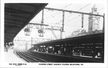
Postcard, Rose Stereograph Co, "Flinders Street, Railway station, Melbourne", mid 1930s
Rose Series postcard No. 63, "Flinders Street, Railway station, Melbourne" looking at platforms 9 and 10 showing track arrangements, signals and platforms with some people.Yields information about the Flinders St railway station platforms.Postcard - printed real photograph with Rose Stereograph Co. name on the rear.flinders st station, platforms, railways -
 Melbourne Tram Museum
Newspaper, Newcastle Herald Newspaper, "Trams may give electric shocks", 13-6-2000
Newspaper cutting about the possibility of electric shocks from tramcars due to the application of too much sand on the tracks, and not allowing the return current. Tram becomes insulated.Yields information about the possibility of electric shocks from tramcars if excessive sand applied to tracks.Newspaper cutting from the Newcastle Herald, NSW newspaper titled "Trams may give electric shocks""NH 13.6.00"trams, tramways, melbourne, electrical engineering, tramcars, electricity, safety -
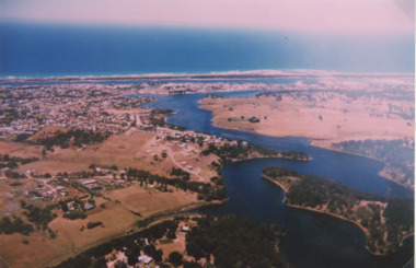 Lakes Entrance Regional Historical Society (operating as Lakes Entrance History Centre & Museum)
Photograph - North Arm Lakes Entrance, 1993c
Also second aerial photograph showing Blairs Road track to Wyanga Winery glimpse of Tarra Landing number 03857.1 size 10 x 15 cmAerial photograph of North Arm Frenchmans Gully and Wyanga Winery lower left Tarra Landing estate centre North Arm and Cunninghame Arm Lakes Entrance Victoriaaerial photograph, houses, settlement, township -
Bendigo Historical Society Inc.
Map - CAMPBELL COLLECTION: BENDIGO AND DISTRICT MAPS, 11-4-29
Map. Huntly, Parishes of Huntly, Nerring and Neilborough. Scale 20 chains to 1 inch. Total area 4738 acres. Prepared in W.P.B. from A and C.L. Plans by W.J. Galbraith 11-4-29. Eaglehawk. IN PENCIL top right of map: Euc areas 1974 Scott & Cole Comp 5,6,7,8,9,12,13. Laurie C.Raynor 10,11,17, Part 16 South of Scotsmans Track, J.T Pierce 14,15,16 North of Scotsman Track. From Neilborough. G.Ward. A.Sloan. K.Walker at bottom of map. (number 368 in map cupboard 1)W.J.Galbraithmap, bendigo, allotments