Showing 27608 items
matching yarra-river
-
 Greensborough Historical Society
Map, Melbourne and Metropolitan Board of Works. Survey Division, MMBW, Yarra 2500 / 14.23. Diamond Creek, Sutherland Homes, 1979_05
Melbourne and Metropolitan Board of Works. Yarra 2500 [base map] 14.23. Diamond Creek, Sutherland Homes. Parish of Morang 3183 and Nillumbik 3310. Municipality of Diamond Valley 257. Prominent streets Aqueduct Road, Diamond Creek Road, Yan Yean Road and McLaughlans Lane. Features include the abandoned Maroondah aqueduct and Sutherland Cottages.MMBW Map in 1:2500 [scale] series. Cream parchment with green tape reinforcing on edges and punched holes on left edge.mmbw, melbourne and metropolitan board of works, shire of diamond valley, plenty - maps, sutherland homes, maroondah aqueduct -
 Greensborough Historical Society
Map, Melbourne and Metropolitan Board of Works. Survey Division, MMBW, Yarra 2500 / 13.28. Mernda, Wilton Vale, 1977_08
Melbourne and Metropolitan Board of Works. Yarra 2500 [base map] 13.28. Mernda, Wilton Vale. Municipality of Diamond Valley 257 and Whittlesea 239. Prominent streets: Wilton Vale Road. Features include Yan Yean Pipe Track and SEC Transmission Lines. The abandoned rail line (old Whittlesea line) is in the top left corner.MMBW Map in 1:2500 [scale] series. Cream parchment with green tape reinforcing on edges and punched holes on left edge.mmbw, melbourne and metropolitan board of works, shire of diamond valley, mernda - maps -
 Greensborough Historical Society
Map, Melbourne and Metropolitan Board of Works. Survey Division, MMBW, Yarra 2500 / 15.24. Diamond Creek, Grassy Flat Road, 1978_02
Melbourne and Metropolitan Board of Works. Yarra 2500 [base map] 15.24. Diamond Creek, Grassy Flat Road. Parish of Nillumbik 3310. Municipality of Diamond Valley 257. Prominent streets include: Everleigh Drive, Broad Gully Road and Clyde Street. Features include the Diamond Creek, Nillumbik Park and Diamond Creek Reservoir.MMBW Map in 1:2500 [scale] series. Cream parchment with green tape reinforcing on edges and punched holes on left edge.mmbw, melbourne and metropolitan board of works, diamond creek - maps, shire of diamond valley -
 Melbourne Tram Museum
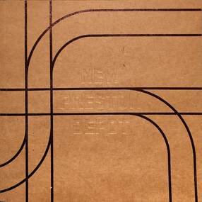
Booklet, Yarra Trams, "New Preston Depot", 4/2016
Booklet issued by Yarra Trams at the time of the opening of the New Preston Depot at the former Preston Workshops, April 2016. Has a forward by Nicholas Gindt, Yarra Trams CEO, photos and plans of the site, facilities, safety considerations, notes on the workshops' history, and nearby services. On the rear cover has the logos of Keolis Downer, Yarra Trams, PTV and the Victorian Government. Yields information about the New Preston Depot and Workshops.Booklet - titled "New Preston Depot" 32 pages including card cover with embossed title and embossed MMTB logo on the rear cover. Two copies held.tramways, preston workshops, preston depot, trams, yarra trams -
 Greensborough Historical Society
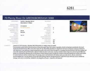
Advertising Leaflet, Barry Plant Greensborough, 70 Plenty River Drive Greensborough, 31/10/2018
Real estate advertisement for 70 Plenty River Drive Greensborough, a 3 bedroom house.This house was listed in February 2019 for $650,000-$700,000. Previous sales: March 2004 for $280,000.Real estate advertisement black text and colour photographplenty river drive greensborough -
![Photograph - Digital image, 24 River Street [Briar Hill], 02/05/2013](/media/collectors/4f729f5697f83e03086015b8/items/572868fc2162f115acc626a5/item-media/572869462162f115acc630d2/item-fit-380x285.jpg) Greensborough Historical Society
Greensborough Historical SocietyPhotograph - Digital image, 24 River Street [Briar Hill], 02/05/2013
This photograph of 24 River Street was taken in 2013 to show changes over 40 years, based on Ron Reynold’s sketches in the 1973 publication “Greensborough and Greenhills” published by Cypress Books.Digital copy of colour photograph.greensborough and greenhills, river street briar hill, ron reynolds -
 Federation University Historical Collection
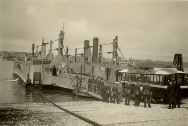
Photograph - Photograph - Black and White, St. Hilda's Bus and band members boarding the Torpoint Ferry, on the River Tamar, 1934
Frank Wright was a renown resident of Smeaton, where he was born on 2 August 1901. He lived at Laura Villa, and attended Smeaton State School. His father William was a gold miner and his mother's name was Sarah. Their family won many singing and instrumental awards. Frank was tutored by Percy Code and was awarded a gold medal for the highest marks in the ALCM examinations in the British Colonies at the age of seventeen years. He became the Australian Open Cornet Champion by the age of eighteen. A year later, Frank conducted the City of Ballarat Band, and later the Ballarat Soldiers’ Memorial Band. He formed the Frank Wright Frisco Band and Frank Wright and his Coliseum Orchestra. These bands won many South Street awards, and Frank as conductor won many awards in the Australian Band Championship contest. In 1933 Frank Wright sailed to England to conduct the famous St Hilda’s Band and was later appointed Musical Director of the London County Council, where he organized many amazing concerts in parks, in and around the London district. He was made Professor of Brass and Military Band Scoring and conducted at the Guildhall of Music and Drama. Frank was often invited to adjudicate Brass Band Championships around Europe, in Australia, including South Street and in New Zealand. The Frank Wright Medal at the Royal South Street competition is awarded to an individual recognized as making an outstanding contribution to brass music in Australia.Black and white photograph of an early 1930's bus boarding a vehicle and passenger chain ferry. A group on men dressed in a band uniform are standing and watching the bus's progress. Land can be seen on both sides of the Tamar River. It is the Torpoint Ferry between Devonport in Plymouth and Torpoint in Cornwall. The men are the St. Hilda's Band, including Frank Wright, the conductor.Written in pencil on back - St Hilda's Bus on Torpoint Ferry between Devon and Cornwall, 1934frank wright, st hilda's band, st hilda's bus, brass band, torpoint ferry -
 Ballarat Tramway Museum
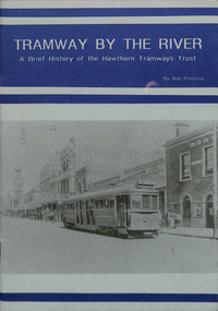
Book, B. Prentice, "Tramway by the River - A Brief History of the Hawthorn Tramways Trust", 1993
Yields information through a booklet that provides a short history of the Hawthorn Tramways Trust and details of some of the rollingstock that provided trams to the SEC Provincial systems. Second edition.Twenty page book including card, blue printing on a grey paper covers titled "Tramway by the River - A Brief History of the Hawthorn Tramways Trust" Bob Prentice, published by Tramway Publications in 1993. Briefly details the tramways operated by the Hawthorn Tramways trust, formation, construction , map, timetables, overhead and depot/workshops and tramcar details. Includes many photographs."4.50" price sticker on front cover.trams, tramways, hawthorn, melbourne, hawthorn depot -
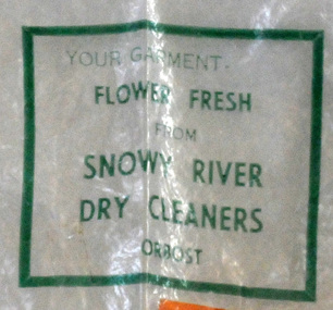 Orbost & District Historical Society
plastic bag, c 1960's
Snowy River Dry Cleaners was situated in Stanley Street, Orbost (previously a hat factory). There was also a shop in the CBD of Orbost. Basil Dowie moved his dry cleaning business from Nicholson Street to 31 Stanley Street where Stuart Hats had been. He had originally bought the business from Laurie Harrington in August 1950. (more information in Orbost & District Historical Society Newsletter No. 138 - John Phillips) This item is from a business no longer existing.A clear plastic bag with green print. - Snowy River Dry Cleaners. attached is orange card - E. Scott 004408Your garment Flower Fresh from Snowy River Dry Cleaners Orbostdry-cleaners-orbost laundry -
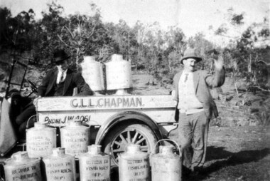 Greensborough Historical Society
Photograph - Digital image, Plenty River Fishermen, 1920c
Plenty River fishermen. Two men with truck and barrels of fish, truck has sign - G.L.L. Chapman House Renovator Northcote. Barrels printed with Return to Fisheries Department Melbourne [or Ballarat]. Digital copy of black and white photograph.plenty river -
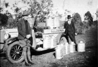 Greensborough Historical Society
Photograph - Digital image, Plenty River Fishermen, 1920c
Plenty River fishermen. Two men with truck and barrels of fish, truck has sign - G.L.L. Chapman House Renovator Northcote. Barrels printed with Return to Fisheries Department Melbourne [or Ballarat].Digital copy of black and white photograph.plenty river -
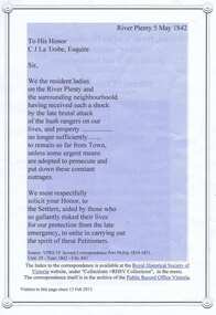 Greensborough Historical Society
Document, Petition from 'Ladies resident on Plenty River', 05/05/1842
Copy of text of the Petition to the Governor of Victoria, C. J. La Trobe, from 'Ladies resident on Plenty River' requesting protection from bushrangers, 5 May 1842, with list of petitioners.Indicates dangers of living in the remote location of Plenty River in 1842 and lists women living in the area.2p. col. printed 2 sidesplenty river, bushrangers, petitions -
 Greensborough Historical Society
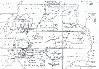
Maps, Greensborough west of Plenty River, 1840o
Areas of Greensborough, west of the Plenty River, showing land holdings in the 1840s. Comprises Sections 8, 9, 10, 14, 15, 16, 17, 18, 19, 20 Parish of KeelbundoraOne A4 photocopy, one A3 enlargementgreensborough, watsonia, lower plenty, janefield -
 Freemasons Victoria - The Lodge of Australia Felix No 1
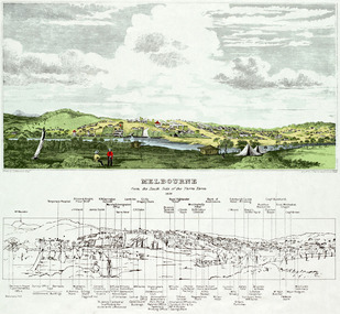
Melbourne 1839
Painting of Melbourne at the time the Lodge held it's inaugural meeting on 23 December 1839 Melbourne Viewed from the south bank of the Yarra RiverThe Lamb in inn the painting is the first meeting place of the Lodge of Australia Felix on 23 December 1839 felix, australi felix, uglv -
 Greensborough Historical Society
Map, Melbourne and Metropolitan Board of Works. Survey Division, MMBW, Yarra 2500 / 13.19. Lower Plenty, Montmorency, Yallambie, 1979_02
Melbourne and Metropolitan Board of Works. Yarra 2500 [base map] 13-19. Lower Plenty, Montmorency, Yallambie. Parishes of Keelbundora 2856 and Nillumbik 3310. Municipalities of Heidelberg 228, Diamond Valley 257 and Eltham 238. Prominent streets include: Elder Street, Para Road, and Main Road Lower Plenty. Includes Watsonia Army Barracks.MMBW Map in 1:2500 [scale] series. Cream parchment with green tape reinforcing on edges and punched holes on left edge.mmbw, melbourne and metropolitan board of works, shire of diamond valley, montmorency - maps, yallambie - maps, lower plenty - maps -
 University of Melbourne, Burnley Campus Archives
Flyer, The University of Melbourne et al, Climate Adaptation Along the Birrarung: A Day For Learning, 30.11.2023
climate adaptation, birrarung, ballerrt mooroop, yarra riverkeeper, merri-bek city council -
 Melbourne Tram Museum
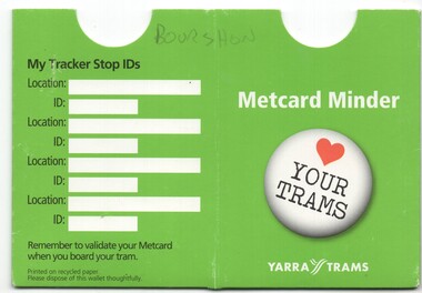
Functional object - Ticket Wallet, Yarra Trams, "Metcard Minder", c2005
Printed and folded card to give a ticket holder or wallet, with the title "Metcard Minder", with Yarra Trams and Tram Tracker and "Love your Trams" logos, with notes about Tram Tracker and space where Stop IDs could be written.Has "Bourshow" written in pencil on front.trams, tramways, metcard, yarra trams, tramtracker, tickets -
 Melbourne Tram Museum
Souvenir - Event Materials, Yarra Trams, "Love your Trams", c2006
Frisbee - fold up type, printed with a "Love your Trams" message. Comprises a cloth sewn within a spring metal suround that could be folded up (and it does) to be placed within the green cloth bag with the Yarra Trams logo.trams, tramways, events, yarra trams, children, marketing -
 Greensborough Historical Society
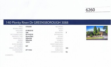
Advertising Leaflet, Barry Plant Greensborough, 140 Plenty River Drive Greensborough, 07/08/2018
Real estate advertisement for 140 Plenty River Drive Greensborough, a 3 bedroom house. This house was sold in August 2018 for $755,000. Previous sales: October 2007 for $425,000; and December 1981 for $72,000.Real estate advertisement black text and colour photographplenty river drive greensborough -
 Greensborough Historical Society
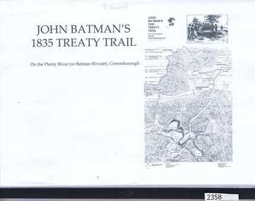
Folder, Dennis Ward, John Batman's 1835 Treaty Trail: on the Plenty River (or Batman's Rivulet), Greensborough / by Dennis Ward, 06/06/1835
This information was collected for a grant application to erect signage along the Plenty River path, outlining the history of this area where early settlement of the area occurred. The application was made by GHS member Dennis Ward.Black spiral bound folder with clear cover containing 18 pages of photograph and text.plenty river trail, plenty river, willis vale, dennis ward -
 Greensborough Historical Society
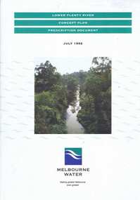
Book, Lower Plenty River concept plan: prescription document, 1992_07
Draft concept plan prepared. by Brett Cheatley, Malcolm Warren and Ian Womersley, Parks and Waterways Planning Division, Melbourne Water. Includes management areas and key strategies for the Lower Plenty River.Book, mainly black and white print, colour photographs and plans, 66 pages. 3 copiesplenty river, melbourne water, lower plenty river -
 Greensborough Historical Society
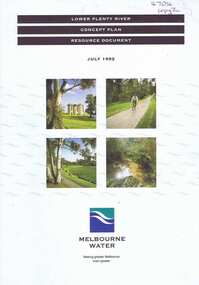
Book, Lower Plenty River concept plan: resource document, 1992_07
Draft concept plan prepared by Brett Cheatley, Malcolm Warren and Ian Womersley, Parks and Waterways Planning Division, Melbourne Water. This document includes information on the heritage and environment of the Lower Plenty River.Book, mainly black and white, colour photographs and plans, 56 pages, 3 copies.plenty river, melbourne water, lower plenty river -
 Eltham District Historical Society Inc
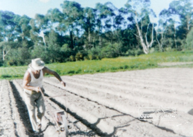
Photograph, Antonio Casonato sowing seeds on the river flats in front of Eltham High School
Antonio Casonato sowing seeds with a device in furrowed soil on the river flats in front of Eltham High School at Fabbro's farm, Eltham. The Fabbro Family operated their farm in Bell Street, Eltham. No date1 colour photographfabbro's farm, eltham, bell street, antonia casonato, seeds -
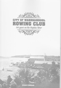 City of Warrnambool Rowing Club
Book, City of Warrnambool Rowing Club - 140 years on the Hopkins River, 2016
This book was launched on 21 February 2016. It details the history of the City of Warrnambool Rowing Club (CoWRC) and includes the five rowing clubs that have operated on the Hopkins River, Warrnambool and been absorbed by CoWRC . This book details the history of five rowing clubs on the Hopkins River, Warrnambool. It includes the clubs importance to the community, coloured and black and white photographs, table of committtees from 1871 and the first documented boating club on the river in 1850. An 85 page A4 book, black and white cover with coloured photographs, table of committees.city of warrnambool rowing club, warrnambool rowing club, warrnambool ladies rowing club, faugh-a-ballagh, hopkins boating club, gordon rowing club, susan finnigan, hopkins river, warrnambool, hopkins river warrnambool -
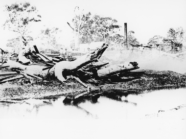 Stawell Historical Society Inc
Photograph, Bush Sawmill beside the Wimmera River in Dunolly 1993
Dunolly 1993. Bush Sawmill beside the Wimmera River. Wooden buildings in Background. Chimney of what appears to be a steam driven engine with flywheel and belt driving a saw bench. Several men in photo.water industry -
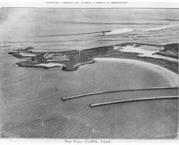 Port Fairy Historical Society Museum and Archives
Photograph, C. 1925
Black and white arial photograph of the Moyne river entrance, the original signed by R.W.Golding.Black and white aerial photograph of Griffith island showing the lighthouse keeper’s compound, the large flagstaff and the river training walls in the foregroundHand written on the back "Port Fairy Moyne River Entrance R. W. Golding Handwritten on the back of the copy "Port Fairyb Harbour 1925"local history, photography, photographs, slides, film, arial, moyne river -
 Greensborough Historical Society
Map, Melbourne and Metropolitan Board of Works. Survey Division, MMBW, Yarra 2500 / 14.22. St Helena, St Katherine's Church, 1979_08
Melbourne and Metropolitan Board of Works. Yarra 2500 [base map] 14.22. St Helena, St Katherine's Church. Parish of Nillumbik 3310. Municipality of Diamond Valley 257. Prominent streets St Helena Road, Weidlich Road, Yan Yean Road and Allumba Drive. Features include St Katherine's Church of England and the St Helena Secondary College site.MMBW Map in 1:2500 [scale] series. Cream parchment with green tape reinforcing on edges and punched holes on left edge.mmbw, melbourne and metropolitan board of works, shire of diamond valley, st helena - maps, st katherines church st helena -
Vision Australia
Text, RVIB Yarra Glen Auxiliary, 1956 - 1997
The Yarra Glen RVIB Auxiliary formed on March 19, 1956. This small collection contains index cards which were maintained by RVIB and contain the amount of donations made by the Auxiliary between 1976 - 1995 as well as the presentations delivered by RVIB employees to Auxiliary meetings between 1978 - 1985. Correspondence to and from RVIB head office ranging between 1990 - 1999. Newspaper articles -- letters -- index cards and various loose papers royal victorian institute for the blind -
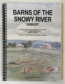 Orbost & District Historical Society
book, Barns of the Snowy River Orbost, 2006
This is a book written by a local historian containing historical information pertaining to Orbost and the surrounding district. A spiral bound book of 191pp. On the front and back covers are coloured print of the Morgan Barn c 1900, an original watercolour, artist unknown. The book documents the distinctive slatted barns of the lower Snowy River, Orbost, Victoria. The book was published by the Orbost Historical Society and was written by May Leatch and Ngaere Donald. It contains B/w photographs, drawings and stories of the barns and their histories.history-agriculture-orbost barns-slatted -
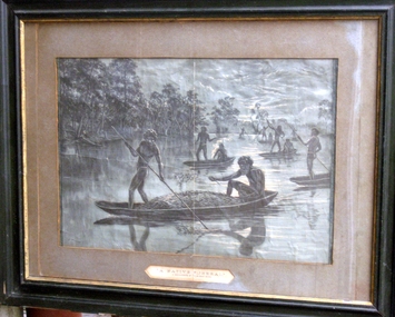 Whitehorse Historical Society Inc.
Newspaper - Framed Cutting, 'A Native Funeral. A reminiscence of the Murray River', December 1885
Donors were:- Hepburn, Mrs A.E. Hepburn, Miss E Hepburn, Mr. Hepburn Mr. Zeogh Holman, Mrs. Evalie.The Illustrated Australian News published 1864-1896 was a pictorial newspaper based in Melbourne. It was published by David Syme & Co. The framed etching was copied from a supplement in the newspaper. The State Library of NSW. Search Manuscripts, Oral History, and Pictures Catalogue, has copies of the newspaper.A black and white etching titled 'A Native Funeral. A reminiscence of the Murray River' in a black frame with gold inner edge and grey mount. Picture features six canoes with lead canoe, in centre, carrying a body covered with foliage. April 2012: During restoration it was found under the original mount board the print 'Supplement to the Illustrated Australian News December 1885' First Nations.Supplement to the Illustrated Australian News December 1885illustrations, etchings