Showing 64430 items
matching henderson-house
-
 Eltham District Historical Society Inc
Opening of Meruka Childcare Co-operative, Meruka Park, 5 Meruka Dr, Eltham, April 1994
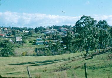
In 1919 J.B. North, a violinist with the then Melbourne Symphonic Orchestra, and Monsieur Leon Lambert, a French architect, who later designed the Glaciarium Ice Skating Rink, purchased three available farms, Looker's, Wright's and Taylor's, approximately 60 acres, the area running along the creek and being bordered by the present day Ryans Road, Karingal Drive and Sherbourne Road. The farms were used for orchards and market gardens. Leon Lambert designed and built two homes on the farm site, one for the North family, ‘Tralford’, and the other, ‘Glen Ellen’, for himself and his wife. The homes were considered as "brother and sister" and they each included in their design an identical bay window in the main living area. "Glen Ellen" originally comprised kitchen, lounge room, inglenook, dining room, bath room and sleepout. Although the home has been extended over the years, much of the original architecture has been retained including timber panelling and three fireplaces. The land was subdivided in approximately 1966 with "Glen Ellen" retaining approximately one half acre of land fronting Meruka Drive. The property then passed from the Charleston family to Gerald and Margaret Sutton in 1976 and again was sold in 1980 and lastly sold again in 1994. The Norths named their house 'Tralford'. According to Marjorie North, the name Meruka was suggested by Alan Gardner and so was apparently not used by the North family. The name appears to be of Indian origin and its connection with the land is not known. ‘Tralford’ stayed in the North family for many years. Eltham Council acquired the house to create Meruka Park. The house was used for some years by the Council as a community arts facility and as emergency accommodation. It fell into disrepair and was demolished about 1990. The Meruka Child Care Centre has been built on the site and incorporates some of the architectural features of the old house. The Co-op was opened in April 1994. The original drive flanked by large old cypress trees remains. These trees are considered to be of local heritage significance and for this reason Meruka Park is covered by a Heritage Overlay under the Nillumbik Planning Scheme. Part of the park has been preserved as habitat for rare local flora. LL's house, named ‘Glen Ellen’, remains in a well-preserved state and fronts Meruka Drive.eltham, meruka child care co-operative, meruka house, meruka park, irene bogle -
 Eltham District Historical Society Inc
Opening of Meruka Childcare Co-operative, Meruka Park, 5 Meruka Dr, Eltham, April 1994
In 1919 J.B. North, a violinist with the then Melbourne Symphonic Orchestra, and Monsieur Leon Lambert, a French architect, who later designed the Glaciarium Ice Skating Rink, purchased three available farms, Looker's, Wright's and Taylor's, approximately 60 acres, the area running along the creek and being bordered by the present day Ryans Road, Karingal Drive and Sherbourne Road. The farms were used for orchards and market gardens. Leon Lambert designed and built two homes on the farm site, one for the North family, ‘Tralford’, and the other, ‘Glen Ellen’, for himself and his wife. The homes were considered as "brother and sister" and they each included in their design an identical bay window in the main living area. "Glen Ellen" originally comprised kitchen, lounge room, inglenook, dining room, bath room and sleepout. Although the home has been extended over the years, much of the original architecture has been retained including timber panelling and three fireplaces. The land was subdivided in approximately 1966 with "Glen Ellen" retaining approximately one half acre of land fronting Meruka Drive. The property then passed from the Charleston family to Gerald and Margaret Sutton in 1976 and again was sold in 1980 and lastly sold again in 1994. The Norths named their house 'Tralford'. According to Marjorie North, the name Meruka was suggested by Alan Gardner and so was apparently not used by the North family. The name appears to be of Indian origin and its connection with the land is not known. ‘Tralford’ stayed in the North family for many years. Eltham Council acquired the house to create Meruka Park. The house was used for some years by the Council as a community arts facility and as emergency accommodation. It fell into disrepair and was demolished about 1990. The Meruka Child Care Centre has been built on the site and incorporates some of the architectural features of the old house. The Co-op was opened in April 1994. The original drive flanked by large old cypress trees remains. These trees are considered to be of local heritage significance and for this reason Meruka Park is covered by a Heritage Overlay under the Nillumbik Planning Scheme. Part of the park has been preserved as habitat for rare local flora. LL's house, named ‘Glen Ellen’, remains in a well-preserved state and fronts Meruka Drive.eltham, meruka child care co-operative, meruka house, meruka park, cr bob manuell, matthew rodscholler -
 Eltham District Historical Society Inc
Opening of Meruka Childcare Co-operative, Meruka Park, 5 Meruka Dr, Eltham, April 1994
In 1919 J.B. North, a violinist with the then Melbourne Symphonic Orchestra, and Monsieur Leon Lambert, a French architect, who later designed the Glaciarium Ice Skating Rink, purchased three available farms, Looker's, Wright's and Taylor's, approximately 60 acres, the area running along the creek and being bordered by the present day Ryans Road, Karingal Drive and Sherbourne Road. The farms were used for orchards and market gardens. Leon Lambert designed and built two homes on the farm site, one for the North family, ‘Tralford’, and the other, ‘Glen Ellen’, for himself and his wife. The homes were considered as "brother and sister" and they each included in their design an identical bay window in the main living area. "Glen Ellen" originally comprised kitchen, lounge room, inglenook, dining room, bath room and sleepout. Although the home has been extended over the years, much of the original architecture has been retained including timber panelling and three fireplaces. The land was subdivided in approximately 1966 with "Glen Ellen" retaining approximately one half acre of land fronting Meruka Drive. The property then passed from the Charleston family to Gerald and Margaret Sutton in 1976 and again was sold in 1980 and lastly sold again in 1994. The Norths named their house 'Tralford'. According to Marjorie North, the name Meruka was suggested by Alan Gardner and so was apparently not used by the North family. The name appears to be of Indian origin and its connection with the land is not known. ‘Tralford’ stayed in the North family for many years. Eltham Council acquired the house to create Meruka Park. The house was used for some years by the Council as a community arts facility and as emergency accommodation. It fell into disrepair and was demolished about 1990. The Meruka Child Care Centre has been built on the site and incorporates some of the architectural features of the old house. The Co-op was opened in April 1994. The original drive flanked by large old cypress trees remains. These trees are considered to be of local heritage significance and for this reason Meruka Park is covered by a Heritage Overlay under the Nillumbik Planning Scheme. Part of the park has been preserved as habitat for rare local flora. LL's house, named ‘Glen Ellen’, remains in a well-preserved state and fronts Meruka Drive.eltham, meruka child care co-operative, meruka house, meruka park, cr pam sladden, mandy press -
 Eltham District Historical Society Inc
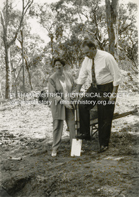
Photograph - Black and White Print, Shire of Eltham, Meruka Child Care Centre, turning the first sod: Cr Pamela Sladden, Peter Staples MHR Jaga Jaga, c.1993
In 1919 J.B. North, a violinist with the then Melbourne Symphonic Orchestra, and Monsieur Leon Lambert, a French architect, who later designed the Glaciarium Ice Skating Rink, purchased three available farms, Looker's, Wright's and Taylor's, approximately 60 acres, the area running along the creek and being bordered by the present day Ryans Road, Karingal Drive and Sherbourne Road. The farms were used for orchards and market gardens. Leon Lambert designed and built two homes on the farm site, one for the North family, ‘Tralford’, and the other, ‘Glen Ellen’, for himself and his wife. The homes were considered as "brother and sister" and they each included in their design an identical bay window in the main living area. "Glen Ellen" originally comprised kitchen, lounge room, inglenook, dining room, bath room and sleepout. Although the home has been extended over the years, much of the original architecture has been retained including timber panelling and three fireplaces. The land was subdivided in approximately 1966 with "Glen Ellen" retaining approximately one half acre of land fronting Meruka Drive. The property then passed from the Charleston family to Gerald and Margaret Sutton in 1976 and again was sold in 1980 and lastly sold again in 1994. The Norths named their house 'Tralford'. According to Marjorie North, the name Meruka was suggested by Alan Gardner and so was apparently not used by the North family. The name appears to be of Indian origin and its connection with the land is not known. ‘Tralford’ stayed in the North family for many years. Eltham Council acquired the house to create Meruka Park. The house was used for some years by the Council as a community arts facility and as emergency accommodation. It fell into disrepair and was demolished about 1990. The Meruka Child Care Centre has been built on the site and incorporates some of the architectural features of the old house. The Co-op was opened in April 1994. The original drive flanked by large old cypress trees remains. These trees are considered to be of local heritage significance and for this reason Meruka Park is covered by a Heritage Overlay under the Nillumbik Planning Scheme. Part of the park has been preserved as habitat for rare local flora. LL's house, named ‘Glen Ellen’, remains in a well-preserved state and fronts Meruka Drive.shire of eltham archives, child care centres, health & community services, meruka child care co-operative, peter staples mhr jaga jaga, cr pamela sladden -
 Eltham District Historical Society Inc
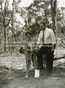
Photograph - Black and White Print, Shire of Eltham, Meruka Child Care Centre, turning the first sod: Cr Pamela Sladden, Peter Staples MHR Jaga Jaga, c.1993
In 1919 J.B. North, a violinist with the then Melbourne Symphonic Orchestra, and Monsieur Leon Lambert, a French architect, who later designed the Glaciarium Ice Skating Rink, purchased three available farms, Looker's, Wright's and Taylor's, approximately 60 acres, the area running along the creek and being bordered by the present day Ryans Road, Karingal Drive and Sherbourne Road. The farms were used for orchards and market gardens. Leon Lambert designed and built two homes on the farm site, one for the North family, ‘Tralford’, and the other, ‘Glen Ellen’, for himself and his wife. The homes were considered as "brother and sister" and they each included in their design an identical bay window in the main living area. "Glen Ellen" originally comprised kitchen, lounge room, inglenook, dining room, bath room and sleepout. Although the home has been extended over the years, much of the original architecture has been retained including timber panelling and three fireplaces. The land was subdivided in approximately 1966 with "Glen Ellen" retaining approximately one half acre of land fronting Meruka Drive. The property then passed from the Charleston family to Gerald and Margaret Sutton in 1976 and again was sold in 1980 and lastly sold again in 1994. The Norths named their house 'Tralford'. According to Marjorie North, the name Meruka was suggested by Alan Gardner and so was apparently not used by the North family. The name appears to be of Indian origin and its connection with the land is not known. ‘Tralford’ stayed in the North family for many years. Eltham Council acquired the house to create Meruka Park. The house was used for some years by the Council as a community arts facility and as emergency accommodation. It fell into disrepair and was demolished about 1990. The Meruka Child Care Centre has been built on the site and incorporates some of the architectural features of the old house. The Co-op was opened in April 1994. The original drive flanked by large old cypress trees remains. These trees are considered to be of local heritage significance and for this reason Meruka Park is covered by a Heritage Overlay under the Nillumbik Planning Scheme. Part of the park has been preserved as habitat for rare local flora. LL's house, named ‘Glen Ellen’, remains in a well-preserved state and fronts Meruka Drive.shire of eltham archives, child care centres, health & community services, meruka child care co-operative, peter staples mhr jaga jaga, cr pamela sladden -
 Eltham District Historical Society Inc
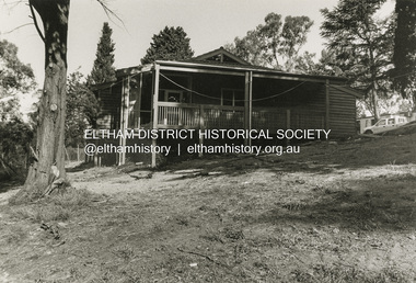
Photograph - Black and White Print, Shire of Eltham, Meruka Child Care Centre, Eltham, c.1994
In 1919 J.B. North, a violinist with the then Melbourne Symphonic Orchestra, and Monsieur Leon Lambert, a French architect, who later designed the Glaciarium Ice Skating Rink, purchased three available farms, Looker's, Wright's and Taylor's, approximately 60 acres, the area running along the creek and being bordered by the present day Ryans Road, Karingal Drive and Sherbourne Road. The farms were used for orchards and market gardens. Leon Lambert designed and built two homes on the farm site, one for the North family, ‘Tralford’, and the other, ‘Glen Ellen’, for himself and his wife. The homes were considered as "brother and sister" and they each included in their design an identical bay window in the main living area. "Glen Ellen" originally comprised kitchen, lounge room, inglenook, dining room, bath room and sleepout. Although the home has been extended over the years, much of the original architecture has been retained including timber panelling and three fireplaces. The land was subdivided in approximately 1966 with "Glen Ellen" retaining approximately one half acre of land fronting Meruka Drive. The property then passed from the Charleston family to Gerald and Margaret Sutton in 1976 and again was sold in 1980 and lastly sold again in 1994. The Norths named their house 'Tralford'. According to Marjorie North, the name Meruka was suggested by Alan Gardner and so was apparently not used by the North family. The name appears to be of Indian origin and its connection with the land is not known. ‘Tralford’ stayed in the North family for many years. Eltham Council acquired the house to create Meruka Park. The house was used for some years by the Council as a community arts facility and as emergency accommodation. It fell into disrepair and was demolished about 1990. The Meruka Child Care Centre has been built on the site and incorporates some of the architectural features of the old house. The Co-op was opened in April 1994. The original drive flanked by large old cypress trees remains. These trees are considered to be of local heritage significance and for this reason Meruka Park is covered by a Heritage Overlay under the Nillumbik Planning Scheme. Part of the park has been preserved as habitat for rare local flora. LL's house, named ‘Glen Ellen’, remains in a well-preserved state and fronts Meruka Drive.shire of eltham archives, child care centres, health & community services, meruka child care co-operative -
 Ringwood and District Historical Society
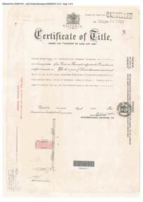
Document, Certificate of Title - W.G. Carter, Grandview Grove, Warranwood, Victoria, (later Bemboka Road) - part of Crown Section Twenty, Parish of Warrandyte, County of Evelyn - 1947
A4 copies of Landata Victoria Historical Search documents - Vol 7052 Fol 1410222. Includes Carter Family Tree property notes. William George Carter of Grandview Grove Ringwood, Nurseryman, is now the proprietor - three acres or thereabouts shown on map (12202a) - 14th March, 1947. Transfer B284834 Registered 21 September, 1961 - 1 acre shown on map (12202c) north of Plymouth Road. NOTES ON GRANDVIEW GROVE PROPERTY (Carter Family Tree extract) The Grandview Grove property was purchased by William (Bill) and Doreen Carter in 1947 as three acres of uncleared bushland. They had a 2 bedroom fibro-cement house built on the land which they informally called "Willoreen". With Doreen looking after sons Peter (born in 1940) and Robin (born in 1950), Bill worked locally at Croydon Dairy. The family spent much of their spare time clearing the land, where Bill then grew and sold fruit, flowers and berries, particularly strawberries, as a hobby and to supplement their income. Bill continued to do so while Peter and Robin were growing up, and after Doreen died in 1958. In 1961 Bill sold one of the three acres to one of his seven sisters, Grace, who lived in Kew but later moved to Rosebud and sold the land without ever building on it. During the 1960s, Grandview Grove was renamed Bemboka Road. After retiring as a milkman, Bill moved to Rosebud, Vic, and in 1977, sold the property to the Anglican Church, who were looking to invest in the site in anticipation of proposed future residential development in the area. As nearby properties were subdivided during the 1980s, the house, which the Church had initially utilised as low-cost family accommodation, was modified internaly to become a church/Sunday school. By the early 2000s, construction of a contemporary-design church and carparking area between the house and street alignment had been completed but the house remained as a detatched meeting room until falling into disrepair and was eventually demolished around 2010. -
 Warrnambool and District Historical Society Inc.
Desk Writing Set, Desk Set
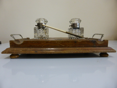
An ink stand was a basic household item in the homes of the more affluent people in past generations before the more common use of the fountain pen and the biro (late 1940s). The ink stand in a home would have been used mainly for letter writing. It was also a basic item in business houses in the same time frame. There is no provenance for this particular item but it is of interest as a household object of the past and is useful for display. Wooden base with indentations for two ink bottles and pens and white metal handles (000633.1). Two ink bottles made of cut glass with white metal necks and hinged glass tops (000633.2 and .3). One ink pen with bone handle, brass top and rusty nib (000633.4).Pen marked 229.2 (old cataloguing number) Base has name in handwriting ‘Mrs A.H. Davidson’ (the donor) communication, ink set, writing set, warrnambool -
 Warrnambool and District Historical Society Inc.
Needle case, Morris & Yeomans Ltd, 1920s
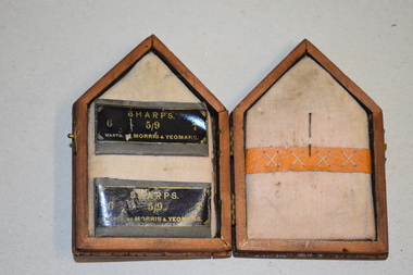
This is a needle case produced in a novelty form. Sewing kits and needle cases were essential items for women to have in their houses, to take with them when travelling and to carry in their handbags for emergency repairs. Today needle cases are still used but less frequently as in past times, depending on the craft skills of the person and the hobbies pursued.This item has no known local significance but it is an interesting example of an early 20th century needle case and is retained for display purposes.This is a needle case in a wooden container made in a rectangular shape with a pointed top. The shape is in the form of a church with an affixed metal or paint shape of a church on the front of the container. The front of the container has been polished. The two sides of the container are affixed with two metal hinges and there is a metal clasp on one side. Part of the metal clasp is missing. Inside the container is padded with white/grey cotton material. On one side are two paper grey and black folders which once contained needles and on the other side there is a middle band to hold other needles or pins. This side has one rusty pin.‘Sharps 5/9 6, 7, Wartd. By Morris & Yeomans’household accessories, history of warrnambool -
 Glen Eira Historical Society
Article - Shoobra Road, 80, Elsternwick, Karinya
Two items about 80 Shoobra Road. 1/ An advertising article dated 16/02/2011 from the Melbourne Weekly Bayside magazine; includes coloured photographs of property and selling features including renovation features. 2/ Research notes from Sands and MacDougalls on tenants and house name by Claire Barton.elsternwick, biggin & scott, fricker geo, shoobra road, estate agents, southern chas w.h., karinya, edwardian style, southern alb.c., leadlights, crowe amy, house names, architectural features, stavrakis bill, ivanhoe -
 Eltham District Historical Society Inc
Photograph, George Coop, Old houses and shop on corner of Crofton and Dickson streets, Echuca, 1962
Very close to entrance of Victoria Park this view is looking southwest along Crofton Street to intersection with Dickson.. The buildings are all attached and the immediate two in the foreground have since been demolished or significantly altered however the old shop building and attached house on the corner (32 Dickson St) remain recognisable today.Digital TIFF file Scan of 35mm Ilford FP3 black and white negative transparencygeorge coop collection, echuca, crofton street, dickson street, houses, shops -
 Phillip Island and District Historical Society Inc.
Photograph, Anderson Family, 1938
Wilhelmena, born 1856 on the ship "Wilhelmena" en route to Australia. Parents Robert and Margaret Anderson. Glen Isla was built in 1868 (added to in 1887-88) to become a Boarding House, run by Wilhelmena. Married James Young, became first Sewing Mistress at the Phillip Island School. died 20/09/1938.Wilhelmena Young seated in cane chair, covered with shawl. Home Glen Isla in background, shortly before her death.local history, photography, photographs, slides, film, wilhelmena young nee anderson, black & white photograph, mrs emma anderson jacobs -
 Greensborough Historical Society
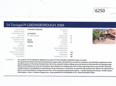
Advertising Leaflet, Barry Plant Greensborough, 14 Terrigal Place Greensborough, 01/10/2018
Real estate advertisement for 14 Terrigal Place Greensborough, a 3 bedroom house. Originally listed by Barry Plant, this property was then listed by Darren Jones before being taken off market. List price $685,000 - $750,000. Previous sales: August 2009 for $460,000; July 1979 $44,200 and March 1979 for $15,750.Real estate advertisement black text and colour photographterrigal place greensborough -
 Greensborough Historical Society
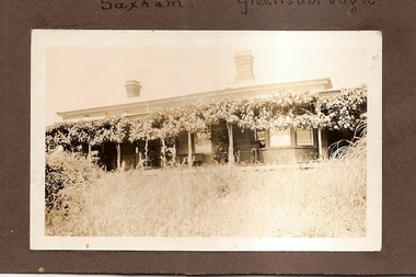
Photograph - Digital Image, Saxam exterior, 1896c
'Saxam' was the home of the Kaye family (1886-1888) then William Santon, a former councillor and Mayor of Heidelberg. Saxam Homestead is a distinctive and substantial timber homestead built in the late 1880s as one of the notable rural properties in the St Helena area. In 2014 the house still stands but is in poor condition with most interior features removed. Digital copy of black and white photograph. saxam, santon family, william santon, kaye family -
 Greensborough Historical Society
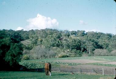
Photograph - Digital image, Frank Robinson, Looking across the Plenty River from Pope's paddock to Blackjack, 1954_
Looking across the Plenty River from Pope's paddock to Blackjack. The Blackjack property, house and acres of fruit orchards ran down to the Plenty River off Hume Street Greensborough and was the home of the Robinson family to late 1956. The photographs were taken as slides by Frank Robinson and digitised by his son James in 2015.Digital copy of colour photograph.blackjack, popes paddock, robinson family -
 Greensborough Historical Society
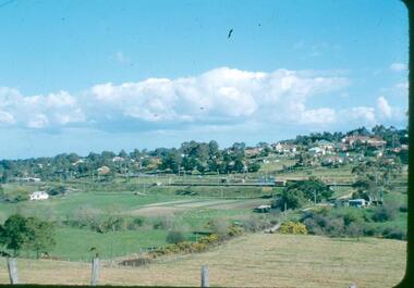
Photograph - Digital image, Frank Robinson, Looking south east from Pope's paddock to the railway line, 1954_
Looking south east from Pope's paddock to the railway line. The Blackjack property, house and acres of fruit orchards ran down to the Plenty River off Hume Street Greensborough and was the home of the Robinson family to late 1956. The photographs were taken as slides by Frank Robinson and digitised by his son James in 2015.Digital copy of colour photograph.robinson family, popes paddock -
 Greensborough Historical Society
Photograph - Digital image, Frank Robinson, Looking south west from Pope's paddock to the swing bridge, 1954_
Looking south west from Pope's paddock to the swing bridge. The Blackjack property, house and acres of fruit orchards ran down to the Plenty River off Hume Street Greensborough and was the home of the Robinson family to late 1956. The photographs were taken as slides by Frank Robinson and digitised by his son James in 2015.Digital copy of colour photograph.robinson family, popes paddock, blackjack -
 Greensborough Historical Society
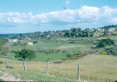
Photograph - Digital image, Frank Robinson, North end of Pope's paddock looking west to township, 1954_
North end of Pope's paddock looking west to township of Greensborough. The Blackjack property, house and acres of fruit orchards ran down to the Plenty River off Hume Street Greensborough and was the home of the Robinson family to late 1956. The photographs were taken as slides by Frank Robinson and digitised by his son James in 2015.Digital copy of colour photograph.robinson family, blackjack, popes paddock -
 Greensborough Historical Society
Photograph - Digital Image, Saxam, now Churinga, 1896c
"Saxam" was the home of the Kaye family (1886-1888) then William Santon, a former councillor and Mayor of Heidelberg. Saxam Homestead is a distinctive and substantial timber homestead built in the late 1880s as one of the notable rural properties in the St Helena area. In 2014 the house still stands but is in poor condition with most interior features removed. A significant Greensborough house.Digital copy of black and white photograph. saxam, churinga, william santon -
 Halls Gap & Grampians Historical Society
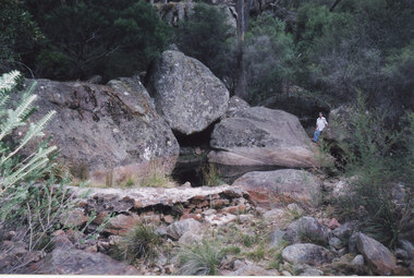
Photograph - Coloured, 24/04/2005
The photo shows a small weir on the Stoney Creek which used to supply water to a number of early businesses in Halls Gap, such as the general store and Grampians House. Each business ran a pipe from the weir to their premises and three outlets can still be seen embedded in the wall. Record 248 was taken at the same time.Photograph of a woman approaching a small weir with three large boulders behind it. The original level of the weir can be seen on the boulders. The additional image is a description of how to get to the weir.scenery, stoney creek -
 Orbost & District Historical Society
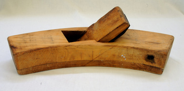
plane, early 20th century
This roughing plane was used by Peter Jensen who came to Martin's Creek (35 miles north of Orbost) in 1890 having been told that Martin's Creek would be on the railway line. He was a cooper who made the casks from silver wattles. He cleared the area for farming and then built an accommodation house, Danebo.Ths item is an example of a woodworking tool used in the late 19th to early 20th century.Large smooth wooden roughing plane. It is curved and has a large metal blade. roughing-plane tool jensen-peter -
 Flagstaff Hill Maritime Museum and Village
Accessory - Clothes Brush, Circa late 1800s or early 1900s
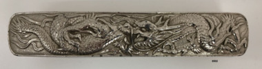
The clothes brush was donated along with a vanity set owned by a local woman who lived in the Harbour Master's house at Warrnambool at the turn of the 19th century. The clothes brush and vanity set were possibly a wedding gift from her mother-in-law, a local business woman who was an importer of 'china and fancy goods'. The item is significant socially as an example of accessories available to, and used by, women in the late 1800s and early 1900s. Historically, it is linked to a local import business ‘Staffordshire House’ in Timor and later Liebig St, Warrnambool, where it most likely came from. The top of the clothes brush has an ornate dragon design constructed from pressed metal (possibly tin or chrome). The natural bristles of the brush have been glued together in small clumps and placed in holes in a wooden base. The wooden base is held within the metal top using small nails.flagstaff hill, warrnambool, maritime village, maritime museum, flagstaff hill maritime museum & village, shipwreck coast, great ocean road, metal, pressed metal, tin, chrome, natural bristles, staffordshire house, harbour master’s house -
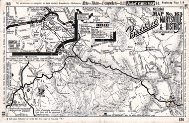 Marysville & District Historical Society
Ephemera (Item) - Pocket card map, Broadbent's Official Road Guides Company, Broadbent's Map No. 163 Marysville & District, 1950s
A pocket card map of Marysville and the district. Drawn map of Marysville and the district. Has a legend, scale and a town map of Marysville. Gives an address for Broadbent's Publishing Office of 475 Collins St Melbourne and a Melbourne telephone number - MR 2021. Reverse has advertisements for Barton's Store and Marylands Guest House in Marysville.A pocket card map of Marysville and the district. Gives information about Marysville and the district. Broadbent's was a prolific publisher of maps. marysville, victoria, maps, broadbent's, barton's store, marylands guest house -
Glen Eira Historical Society
Document - STANLEY STREET, 14, ELSTERNWICK
This file contains two items about this property: 1/MELBOURNE WEEKLY advertisement dated 09/06/2010 giving brief details of house features and renovation details. Includes two coloured photographs. 2/Hand-written details on occupiers of 14 Stanley Street taken from Sands and McDougalls directories.stanley street, elsternwick, architectural features, plaster moulds, bay windows, emery marian mrs, emery percy e., mcdonald wm., riddell yolande s. carre, riddell consett carre, riddell m. e. carre miss, riddell stanley h., riddell stanley mrs., riddell walter j. carre, riddell thos w. carre, chairman board of works, cavers carre, ogg charles a., noisewood, carre street, orrong road, house names, biggin and scott -
 Robin Boyd Foundation
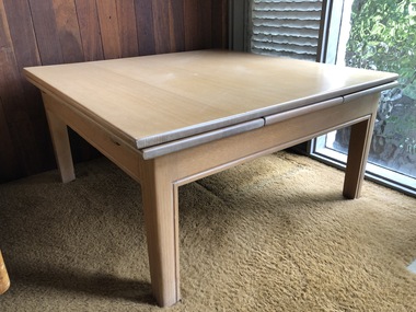
Furniture - Table
This extension table was used as the dining table in the Boyd's Camberwell home. The legs were cut to create a coffee table when it was moved to the Walsh Street house. It was placed along the west facing windowall in the study in Children's Pavilion. Mandie, Penleigh and Suzy Boyd used to watch televison on the set placed on this coffee table.Timber table (expandable). Top surface slides off to reveal two extra flaps.walsh st furnishings, robin boyd, ohm2022, ohm2022_34 -
 National Wool Museum
Book, Knitting, Villawool Knitting Book no. 91
This knitting pattern book was published by the Villawood Textile Company, Sydney and contains knitting patterns for womens knitted garments. The photographs were taken inside Villawoods own knitting mill, in the dye house, the spinning department and the winding and knot detecting rooms. The mill manager, Stanley Harrison, can be seen on the back cover.BOOK 91 / LADY'S DESIGNS IN / 12 PLY EQUIVALENTS / BY / Villawool / 2'9knitting handicrafts - history textile mills, villawood textile company, knitting, handicrafts - history, textile mills -
 Melbourne Legacy
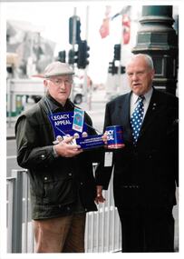
Photograph, Legacy Appeal 2003, 2003
The President of Legacy, David Ford with an volunteer badge seller that could be Legatee Graham Riches. Another photo one of the army personnel from the photos in Legacy house earlier in the day collecting money from a member of the public. Same group of photos as 00604 so the date is assumed to be Badge Week in September 2003.A record of fundraising in Badge Week.Colour photo x 2 of badge sellers in Legacy Week.Printing on the back "legacy appeal, fundraising, badge week -
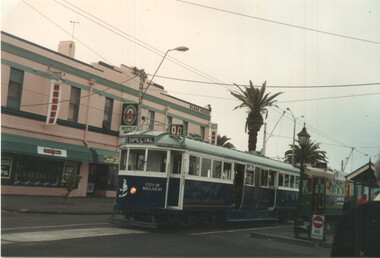 Ballarat Tramway Museum
Photograph - BTM W4 671 at South Melbourne Beach, David Frost, 13/4/1996
Colour print of BTM W4 class tram 671 in the City of Ballarat colours on an BTM organised tour in conjunction with the Rail Tourist Association. Photographed by David Frost at the South Melbourne Beach, route 1 terminus with the Bleak House hotel in the background. Date 13-4-1996. Z3 149 is at the terminus as well.Demonstrates the work of BTM and the City of Ballarat tram.Colour photograph print on Kodak paper.btm, tram 671, w4 class, tramways, trams, tours, south melbourne beach -
 Kew Historical Society Inc
Plan - Subdivision Plan, J R Mathers & McMillan, Heart of Richmond Estate : Richmond, 1928
"In 1928 the land on the east side of Johnson Street was subdivided in 60 lots for the ‘Heart of Richmond Estate’. The houses in the subdivision, along the east side of Johnson Street, and in the newly created Hollick, Cole and Kennedy streets were constructed from 1928 to 1937." (Source: City of Yarra Heritage Gaps Review One 2013)Portion of subdivision plan pasted on to cardboard. Area includes Johnson Street, Victoria Street, Kennedy Street, Cole Street, Hollick Street, Bennett StreetTitle Certificate Vol.2381, Folio 476130 Phillips, Fox & Masel, 440 Little Collins Street, Melbourne (Local estate agent: Jas. R. Mathers & McMIllan, 136 Cotham Road, Kew)subdivision plans - richmond (vic.), heart of richmond estate