Showing 3082 items
matching bendigo mine
-
 Bendigo Historical Society Inc.
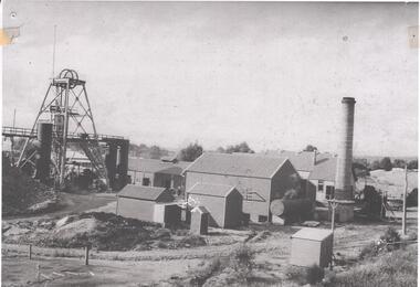
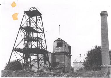
Photograph - NORTH DEBORAH GOLD MINE GOLDEN SQUARE
Black and white photograph of North Deborah Gold Mine, 1940's. View of entire site showing poppet head, trestleway, engine house, chimney stack. Two ore bins to the right of poppet head. 1920's vehicle on far right of photo. Country style outhgouse in foreground of photo. Chimney stack on RH side. -
 Bendigo Historical Society Inc.
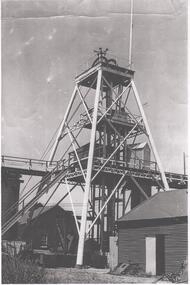
Photograph - NORTH DEBORAH GOLD MINE
Black and white photograph, copy, of the North Deborah Gold Mine poppet head, possibly taken in the 1940's. The trestle way and sky shaft used to convey ore to the landing brace are visible. Poppet head legs are metal and painted white. Corrugated iron sheds on right and in background. Air raid sirens on the top of the poppet head were used during World War 2 to warn the good citizens of Bendigo of any impending attack.bendigo, mining, north deborah gold mine -
 Bendigo Historical Society Inc.
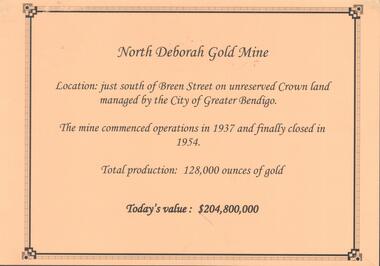
Photograph - NORTH DEBORAH GOLD MINE
... BENDIGO Mining north deborah gold mine Kay MacGregor, Bendigo ...Display interpretive sign for North Deborah Gold Mine. Mine located just south of Breen Street. Commenced operations in 1937 and closed in 1954. Total production 128,000 ounces of gold.Kay MacGregor, Bendigo Historical Societybendigo, mining, north deborah gold mine -
 Bendigo Historical Society Inc.
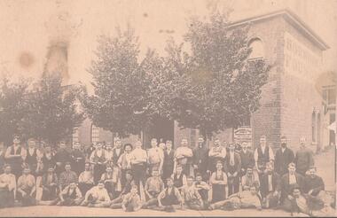
Photograph - HORWOODS FOUNDRY BENDIGO
... Bendigo Historical Society Inc. Bendigo Historical Society ...Sepia tint photograph, copy. Image shows workers sitting outside the Horwood's Foundry, corner of Vine and Mackenzie Streets, C1880. Brick building behind workmen. 'Horwood & Sons' written on window. On side of building, RH wall is written 'Horwood's Foundry'. Horwood's manufactured mining machinery of various types. Their logo is on the stampers at the Deborah Gold Mine.bendigo, business, horwood's foundry -
 Bendigo Historical Society Inc.
Photograph - DEBORAH GOLD MINE 1930'S
... BENDIGO Mining deborah gold mine Black and white photograph, copy ...Black and white photograph, copy, of the Big Deborah Gold Mine, possibly taken in the 1930's. Deborah mine was near the junction of Abel and Adam Street, Golden Square. Image shows the mine site, a square brick chimney on the extreme RH side, engine room and stamper sheds in the middle and steel poppet head on LH side. Colour photo of Big Deborah, minus less the winding wheels at the top of the poppet legs.bendigo, mining, deborah gold mine -
 Bendigo Historical Society Inc.
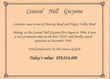
Document - CENTRAL NELL GWYNNE GOLD MINE
Interpretive sign and 4 photos Central Nell Gwynne Gold Mine, used in display. Central Nell Gwynne was located near the corner of Marong Road and Happy Valley Road. Opened in 1906, ceased operation in December 1949. Total production: 61,884 ounces of Gold. Today's Value: $99,014,400. Photos: a. Colour photo, concrete footings at mine site, April 2012. b. Colour photo, Central Nell Gwynne poppet head, April 2012.Poppet head painted white with red trim. Concrete footings in foreround. c. Central Nell Gwynne mine site 1930's. Poppet head and engine room sheds on LH side, trestle way to primary crusher and crushing battery. Tailing dam in immediate foreground. on RH side. Sand heaps in middle foreground. d. Central Nell Gwynne Mine 1930. Underground view, men holding carbide lamps working at 265 level in mine. Large quartz spur formation visible in foreground.bendigo, mining, central nell gwynne -
 Bendigo Historical Society Inc.
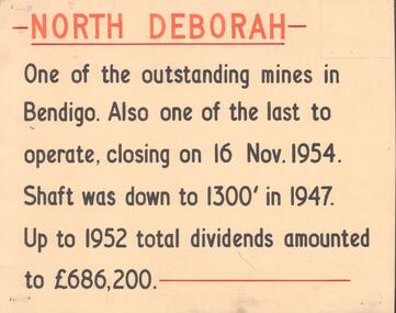
Document - NORTH DEBORAH , DEBORAH, CENTRAL NELL GWYNNE AND NAPOLEON GOLD MINES
Five interpretive cards used for displays, yellow with black and orange text, describing the North Deborah, Deborah, Central Nell Gwynne and Napoleon Gold Mines. a. North Deborah: closed 16th November 1954. Shaft was 1300 feet deep. Total dividends 686,200 pounds. b. Deborah: underground operations suspended 1952, shaft 2076 feet. c. Central Nell Gwynne: operations ceased at end of 1949, shaft depth 1933 feet. d. Napoleon: first subsidiary company formed by BML to carry out comprehensive programme of development along Napoleon anticline. Shaft 1054 feet in 1937 when opertions ceased. e. Devonshire Sands, formed in 1933. Cyanide leaching plants installed on sand tailings heaps at Bendigo.Albert Richardsonbendigo, mining, north deborag mining company -
 Bendigo Historical Society Inc.
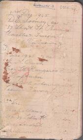
Document - CENTRAL DEBORAH GOLD MINE EMPLOYEES NAMES 1945 TO 1948
Small notebook, lined pages. Names, addresses and mining experience listed in pencil. Dates range from 1945 to 1948. Page near back of notebook details Spargo Creek Mine expenditure and shaft team.bendigo, mining, central deborah gold mine -
 Bendigo Historical Society Inc.
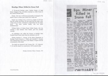
Newspaper - CENTRAL DEBORAH GOLD MINE MINING FATALITY
Newspaper article and typed copy of same, detailing the fatal accident that occurred at the mine on the 22nd January 1953, in which Herbert Hunter of Kangaroo Flat was killed. ' Hunter was working at No 16 level at a depth of 1270 feet from the surface and about 500 feet south from the shaft when a large piece of stone , estimated to wrigh about one ton, broke away. The stone crushed Hunter, who was killed instantaneously' Bendigo Advertiser article dated Friday 23rd January, 1953.bendigo, mining, central deborah gold mine -
 Bendigo Historical Society Inc.
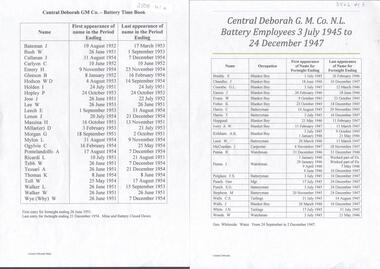
Document - CENTRAL DEBORAH GOLD MINE BATTERY TIME BOOK 1945 TO 1954
Two typed alphabetical listing of battery employees at the Central Deborah Gold Mine. One list covers period from 3rd July1945 to 24th December 1947. Other list covers period 26th June 1951 to 21st December 1954, when the mine and battery closed down.bendigo, mining, central deborah gold mine -
 Bendigo Historical Society Inc.
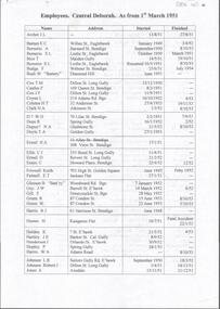
Document - CENTRAL DEBORAH GOLD MINE EMPLOYEES 1950 TO 1953
Typed document alphabetical listing of employees at the Central Deborah Gold Mine, dates from 1950 to 1953. Name of employee, address, start date and finish date included.bendigo, mining, central deborah gold mine -
 Bendigo Historical Society Inc.
Map - GEOLOGICAL MAP BENDIGO GOLD FIELD
Geological map Bendigo gold field. Showing anticlines, synclines, shafts, alluvial, contours. Produced by the deprtment of mines. Two originals plus two laminated copies -
 Bendigo Historical Society Inc.
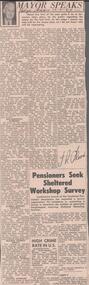
Newspaper - ALBERT RICHARDSON COLLECTION: THE MAYOR SPEAKS: MINE SITES
Newspaper article 'The Mayor Speaks' dated 12th August 1967, Bendigo Advertiser. Article by J.R. Flood. Mayor of Bendigo, detailing the location of mines including the Duchess of Edinburgh on the New Chum line, the mines on the Christmas line of reef, the Deborah reef mines, and the Sheepshead reef. Mine reclamation schemes are also addressed in the articlebendigo, mining, reef lines and mines -
 Bendigo Historical Society Inc.
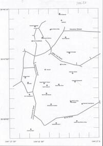
Document - CENTRAL DEBORAH GOLD MINE : GOLDEN SQUARE MINE SITES
... BENDIGO Mining golden square mine sites Map showing mines ...Map showing mines in the Golden Square, Diamond Hill area. Roads include Diamond Hill Road, Burns Street, Woodward Road, Belle Vue Road, Houston Street. Latitude and Longitude on map.bendigo, mining, golden square mine sites -
Bendigo Historical Society Inc.
Document - NEW CHUM AND BELLEVUE EXTENDED TRIBUTE
Share register, 111 pages, brown cover leather spine and corners. Alphabetical list of share holders and financial transactions 1871 - 1872. Stuck inside front cover is the registration of the company with the Court of Mines Sandhurst, dated 3rd day of October, 1871. Some pages in the register have been overwritten with lists of farm purchases, potentially the same family who wrote in the pages of share register catalogued at catalogue number 3656.bendigo, mining, new chum and bellevue extended mine -
Bendigo Historical Society Inc.
Document - NEW CHUM AND BELLEVUE MINEK SHARE REGISTER 1871
Share register, 123 pages, dark green fabric cover, brown leather bindings on corners and spine.On cover on buff label ' New Chum & Bellevue, Ex Tribute Co No 2' Stuck to inside of front cover is a memorial lodged with the Court of Mines Sandhurst for the New Chum and Bellevue Extended Tribute Company on the 29th day of September, 1871. Journal contains alphabetical list of names of shareholders 1871 - 1872 and financial transactions. Journal has been overwritten and has text and pencil diagrams drawn on pages that seem to relate to a plumbing business, date mid 1960's.bendigo, mining, new chum and bellevue extended mine -
Bendigo Historical Society Inc.
Document - SOUTH NEW MOON MINING AUCTION
South New Moon Mine, four page typed list of items auctioned on Tuesday and Wednesday, 18th and 19th March, 1941. By order of the legal Manager A.J. Phillips, 422 Collins Street, Melbourne. Copy taken from an original document prepared by Albert Richardson. Original catalogue number 3601b.bendigo, mining, south new moon mine -
Bendigo Historical Society Inc.
Document - BENDIGO MINES AND MANAGERS
... BENDIGO Mining mines and managers Thirty five page document ...Thirty five page document, alphabetic list of mines with names of managers. No dates given. Mine in document 'Back Creek Quartz Mining Company, Moran, M. For example the Back Creek Quartz Mining Company ' dated at Sandhurst this 17th day of October, 1871. Matthew Moran Manager, Witness Andrew W. Moran. (Victorian Government Gazette 67, Date: Friday, October 20th 1871) Mines appear to be those listed in the early 1870's and published in the Government Gazette 0bendigo, mining, mines and managers -
Bendigo Historical Society Inc.
Document - NEW MOON MINE RESOURCES AND FUTURE PROSPECTS REPORT
Copy of extract from the Bendigo Advertiser, 22nd November, 1906 spiral bound with plastic cover. On front: 'New Moon Mine Site, its resources and future prospects'. Document contains financial reports, gold extracted, shareholders, battery manager's report, map of leases held by New Moon Co and photos, see below. Photo of Managers of New Moon Co., H.E. Jones Mining Manager, J.C. McCoy Engineer, R.A. Dewar Battery Manager. Photo of directors: Joseph LanFranchi, W.B. Walker, Daniel Murdoch, John Green, Alexander Hay and Edward Bright. Photos include view from base of poppet legs showing tramway and crushing machine, battery and mine, miners at the 1045 level.bendigo, mining, new moon co. nl -
Bendigo Historical Society Inc.
Document - UNDERGROUND SURVEY OF BENDIGO MINES
... BENDIGO Mining garden gully line of reef mines Jems Stirling ...Two page document, 'Underground survey of Bendigo, report on Constellation Company's Mine on northern extension of the Garden Gully line of reef. Report on the New Chum Railway Reserve Company and the Shenandoah Company, the New Chum Railway Co being immediately south and the Shenandoah Co immediately north of the railway line. Two maps Constellation Co. Mine shaft and New Chum Railway and Shenandoah auriferous reef below 2700 feet.Jems Stirling, geologist and W.H Cundy Underground Surveyor, Department of Minesbendigo, mining, garden gully line of reef mines -
Bendigo Historical Society Inc.
Document - GARDEN GULLY LINE OF REEF, LEASE BLOCKS 5360 AND 5361
Two page document titled ' Report on lease blocks Nos. 5360 and 5361 Garden Gully line of reef, Bendigo. Produced by the Department of Mines 1899. The area described is about 'one mile and a quarter southeast from the centre of the city of Bendigo, immediately south of the Great Southern Gold Mining Company's workings and is intersected by two auriferous gullies ... Salomon's Gully and Derwenter's Gully'. The alluvial deposits, the Garden Gully line, the Great Souther Co.and old workings are discussed in the paper. A map of the Garden Gully line of reef is attached to the report, showing claimholders and mine names along that section of the reef. Mines named on the map: Great Southern Garden Gully United Ulster Londonderry Burrows Horwoods Sea Amalgamated Garden Gully United Victory and Pandora Unity Carlisle and Garden Gully and Passbye United Cornish United Koch's PioneerJames Stirling, Government Geologistbendigo, mining, garden gully line of reef mines -
Bendigo Historical Society Inc.
Document - HERCULES AND CENTRAL NELL GWYNNE GOLD MINE SHEEPSHEAD REEF
... as the Hercules and Energetic Gold Mine. 1917 - 1922 by Bendigo... and Energetic Gold Mine. 1917 - 1922 by Bendigo Amalgamated Goldfields ...Handwritten one page document. Details about the Hercules Gold Mine, Long Gully which operated from 1911 - 1917 as the Hercules and Energetic Gold Mine. 1917 - 1922 by Bendigo Amalgamated Goldfields Company and 1922 - 1950 as an entirely new company. The Central Nell Gwynne on the Nell Gwynne (central area only) 1932 - 1949.Albert Richardsonbendigo, mining, hercules, energetic, nell gwynne -
Bendigo Historical Society Inc.
Document - BIG BLUE GOLD MINE
Two page document detailing aspects of the operation of the Big Blue Gold Mine. Mining Manager William Hicks. First page details mine operation as at 16.12.1903, 1906 and 1907. Second page, various references including Dicker's Mining Record 1862. Prepared by Albert Richardson.bendigo, mining, big blue -
Bendigo Historical Society Inc.
Document - NEW CHUM LINE OF REEF MUNGO GROUP EAGLEHAWK
Two page document detailing the Mungo Group of Mines along the New Chum line of reef, Eaglehawk. The mines described are: Ellenborough, 2100 feet deep St Mungo, 2,600 feet deep The Lady Barkly, 1,350 feet deep, close to Upper Road with a 40 head battery on the other side. South St Mungo, known as the Governor Barkly in the earlier days. Small map on second page shows the location of the Sadowa shaft, St. Mungo shaft and the Lady Barkly shaft. Victoria Street and Upper Road marked on the map. 'Between Caldwells Road and Victoria Street and Upper Road intersection, nine mines and three crushing batteries worked at one period. All on the New Chum line of reef.' Not signed but most probably written by Albert Richardson.bendigo, mining, mungo group of mines, eaglehawk -
Bendigo Historical Society Inc.
Document - BENDIGO AND VICTORIA HILL REPORT ON GEOLOGY
Report, 8 pages, on the geology of Bendigo district and Victoria Hill, produced by the Geological Survey Dept., Victorian Government. G.J. Medwell, Geologist. 19.10.1967. On front 'Geological Survey of Victoria. Mines Department Victoria. Report on Geology of Bendigo and of Victoria Hill Area' Letter attached inside front cover to J.C.Balfour, Minister of Mines to G.A. Lambert, Liberal Party, Sunshine, Victoria, sent with book for his information. Report contains: Cobaw batholith and North Harcourt Bendigo goldfield generally Trought, reefs, saddles and spurs Victoria Hill mines; Victoria Consols, Great Central Victoria, Victoria Quartz, Lansells 180, North Old Chum. Maps attached show part of New Chum line of reef and a handdrawn map of Rae's Cutting.bendigo, mining, victoria hill, bendigo goldfield -
Bendigo Historical Society Inc.
Document - CENTRAL NELL GWYNNE MINE SPECIAL REPORT
4 page flimsy carbon copy of a typed report on the Nell Gwynne Gold Mining Company NL, dated 29.9.1948. Author K.F. Heinze, Mine Manager, Robert Bentley. Introductory comments: 'shaft sinking was commenced at a point 40 feet below the 1,560 feet plat'. Report includes financial details of mining costs.bendigo, mining, central nell gwynne gold mining co -
Bendigo Historical Society Inc.
Document - HUSTLERS REEF RESERVE CONSERVATION MANAGEMENT PLAN
Conservation management plan (112 pages) prepared by Lee Andrews & Associates, Heritage Consultants, in 2011, for the Hustlers Reef Reserve. The reserve cover the site of the former Great Extended Hustlers Mine site. Leigh McKinnons amendments to the plan are included with the document. History of the site, a physical survey and analysis, comparative analysis, cultural significance and conservation policy are addressed in the document.bendigo, mining, great extended hustlers mine site -
 Bendigo Historical Society Inc.
Document - GILLIES COLLECTION: THE CENTRAL DEBORAH GOLD MINE AND THE GILLIES CRIB ROOM
The central Deborah gold mine and the crib room by Doris Leadbetter. Five pages document.bendigo, business, gillies bros -
 Bendigo Historical Society Inc.
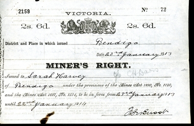
Legal record - WES HARRY COLLECTION: THREE MINER'S RIGHT / RESIDENCY PERMITS
The Miner’s Right has a long history in Australia. Still in use today, it was first established in Victoria in 1855, as a replacement for the Gold License (which had been introduced in Victoria in 1851). The Miner’s Right was subsequently adopted by other Australian colonies. Unlike the Gold License, the early Miner’s Right, in addition to the right to prospect for gold, also carried with it certain other advantages, such as property rights and voting rights. The Miner’s Right came about as a recommendation of a government-appointed commission, which had been appointed on 1854 to look into the troubles on the Victorian goldfields, especially regarding the Eureka Rebellion.Three Miner's Rights / Residency Permits for leases on the corner of Holdsworth Road and Wood Street, Long Gully, Bendigo (Area known as American Gully - downstream of the American Mine): a and b No 72 Sarah Harvey, dated 23/01/1913 c and d No 23148 Evalina Gifford Vivian Harvey, dated 14/09/1926 e and f No 23149 Thomas George Harvey, dated 14/09/1926 Issued by the Victorian Government at a cost of two shillings and six penceVictorian State Governmentwes harry collection, miner's right, bendigo, history, long gully bendigo -
Bendigo Historical Society Inc.
Document - BENDIGO & SANDHURST GOLD MINING COMPANIES FROM 1871, 1871-1950
... Bendigo Historical Society Inc. Bendigo Historical Society ...Typed copy of the Bendigo & Sandhurst Gold Mining Companies From 1871. Vol 1 Victorian Government Gazettes. Eight pages. Includes Mine name, Reef/Gully, Place/Suburb, Mine Manager