Showing 2415 items matching " infrastructure"
-
 Eltham District Historical Society Inc
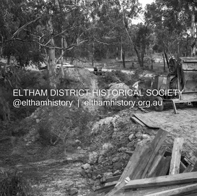
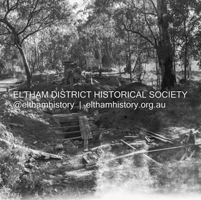
Negative - Photograph, J.A. McDonald, Henley Road at Watsons Creek, Apr. 1961
... Infrastructure...In many situations, the photos provide a tangible visible record of infrastructure that existed throughout the early days of the Shire. ...Henley Road at Watsons Creek looking easterly along centreline from west abutment Early April 1961Record of various Shire of Eltham infrastructure works undertaken during the period of 1952-1962 involving bridge and road reconstruction projects, sometimes with Eltham Shire Council Project Reference numbers quoted. It was during this period that a number of significant improvements were made to roads and new bridges constructed within the shire that remain in place as of present day (2022). In many situations, the photos provide a tangible visible record of infrastructure that existed throughout the early days of the Shire. The album was put together by or under the direction of the Shire Engineer, J.A. McDonald.infrastructure, shire of eltham, bend of islands, cr. charis pelling, henley road, henley road bridge, kangaroo ground, oxley bridge, watsons creek, w.e. wolf, bridge construction, road construction, 1961-04 -
 Eltham District Historical Society Inc
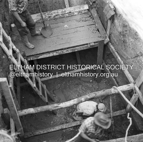
Negative - Photograph, J.A. McDonald, Henley Road at Watsons Creek, Apr. 1961
... Infrastructure...In many situations, the photos provide a tangible visible record of infrastructure that existed throughout the early days of the Shire. ...Henley Road at Watsons Creek showing excavation at western pier Rock at contract level, slight underground flow Early April 1961Record of various Shire of Eltham infrastructure works undertaken during the period of 1952-1962 involving bridge and road reconstruction projects, sometimes with Eltham Shire Council Project Reference numbers quoted. It was during this period that a number of significant improvements were made to roads and new bridges constructed within the shire that remain in place as of present day (2022). In many situations, the photos provide a tangible visible record of infrastructure that existed throughout the early days of the Shire. The album was put together by or under the direction of the Shire Engineer, J.A. McDonald.infrastructure, shire of eltham, bend of islands, cr. charis pelling, henley road, henley road bridge, kangaroo ground, oxley bridge, watsons creek, w.e. wolf, bridge construction, road construction, 1961-04 -
 Eltham District Historical Society Inc
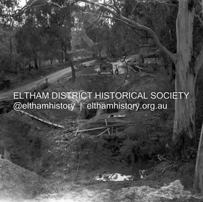
Negative - Photograph, J.A. McDonald, Henley Road at Watsons Creek, Apr. 1961
... Infrastructure...In many situations, the photos provide a tangible visible record of infrastructure that existed throughout the early days of the Shire. ...Henley Road at Watsons Creek looking westerly along centreline from east abutment Early April 1961Record of various Shire of Eltham infrastructure works undertaken during the period of 1952-1962 involving bridge and road reconstruction projects, sometimes with Eltham Shire Council Project Reference numbers quoted. It was during this period that a number of significant improvements were made to roads and new bridges constructed within the shire that remain in place as of present day (2022). In many situations, the photos provide a tangible visible record of infrastructure that existed throughout the early days of the Shire. The album was put together by or under the direction of the Shire Engineer, J.A. McDonald.infrastructure, shire of eltham, bend of islands, cr. charis pelling, henley road, henley road bridge, kangaroo ground, oxley bridge, watsons creek, w.e. wolf, bridge construction, road construction, 1961-04 -
 Eltham District Historical Society Inc
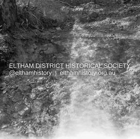
Negative - Photograph, J.A. McDonald, Henley Road at Watsons Creek, Apr. 1961
... Infrastructure...In many situations, the photos provide a tangible visible record of infrastructure that existed throughout the early days of the Shire. ...Henley Road at Watsons Creek looking westerly along centreline from east abutment Early April 1961Record of various Shire of Eltham infrastructure works undertaken during the period of 1952-1962 involving bridge and road reconstruction projects, sometimes with Eltham Shire Council Project Reference numbers quoted. It was during this period that a number of significant improvements were made to roads and new bridges constructed within the shire that remain in place as of present day (2022). In many situations, the photos provide a tangible visible record of infrastructure that existed throughout the early days of the Shire. The album was put together by or under the direction of the Shire Engineer, J.A. McDonald.infrastructure, shire of eltham, bend of islands, cr. charis pelling, henley road, henley road bridge, kangaroo ground, oxley bridge, watsons creek, w.e. wolf, bridge construction, road construction, 1961-04 -
 Eltham District Historical Society Inc
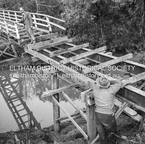
Negative - Photograph, J.A. McDonald, Henley Road at Watsons Creek, Apr. 1961
... Infrastructure...In many situations, the photos provide a tangible visible record of infrastructure that existed throughout the early days of the Shire. ...Henley Road at Watsons Creek looking westerly showing west abutment excavation Mid April 1961Record of various Shire of Eltham infrastructure works undertaken during the period of 1952-1962 involving bridge and road reconstruction projects, sometimes with Eltham Shire Council Project Reference numbers quoted. It was during this period that a number of significant improvements were made to roads and new bridges constructed within the shire that remain in place as of present day (2022). In many situations, the photos provide a tangible visible record of infrastructure that existed throughout the early days of the Shire. The album was put together by or under the direction of the Shire Engineer, J.A. McDonald.infrastructure, shire of eltham, bend of islands, cr. charis pelling, henley road, henley road bridge, kangaroo ground, oxley bridge, watsons creek, w.e. wolf, bridge construction, road construction, 1961-04 -
 Eltham District Historical Society Inc
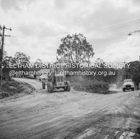
Negative - Photograph, J.A. McDonald, Sherbourne Road, Montmorency, c. July 1962
... ...Infrastructure...In many situations, the photos provide a tangible visible record of infrastructure that existed throughout the early days of the Shire. ...View looking west across Sherbourne Road to intersection of Rattray Road from present-day forecourt entrance to 7-Eleven Eltham service station The BP Service Station is now an Ampol Service Station (2022) Google Street View Apr.. 2022 https://goo.gl/maps/LM4APKCwj1ohBDPv5Record of various Shire of Eltham infrastructure works undertaken during the period of 1952-1962 involving bridge and road reconstruction projects, sometimes with Eltham Shire Council Project Reference numbers quoted. It was during this period that a number of significant improvements were made to roads and new bridges constructed within the shire that remain in place as of present day (2022). In many situations, the photos provide a tangible visible record of infrastructure that existed throughout the early days of the Shire. The album was put together by or under the direction of the Shire Engineer, J.A. McDonald.1962-07, ampol service station, bp service station, montmorency, rattray road, service station, sherbourne road, graders, infrastructure, public telephone box (red), reconstruction works, road construction, shire of eltham -
 Eltham District Historical Society Inc
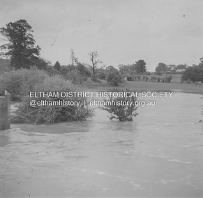
Album - Photograph, J.A. McDonald, Eltham-Greensborough Road, 18 Oct. 1956
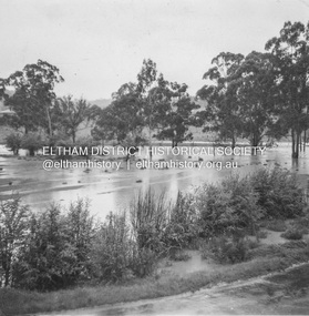
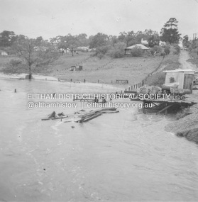
... Infrastructure...In many situations, the photos provide a tangible visible record of infrastructure that existed throughout the early days of the Shire. ...Bridge Street Bridge Flooding on Hill’s property 18th October 1956 This view is looking west north west from the Bridge Street Bridge across the present day Eltham Skatepark. The shed visibile in the distance is directly opposite Brisbane Street where it used to run into Susan Street but now turns the corner. To the right of the shes is the site for present-dayHarris Plumbing which was formerly occupied by Sibbel Builders; to the left the site now occupied by Bunnings. At the skyline to the right of centreeline is a gap in the trees where the railway line runs. The Silver Street bridge over the railway is visible. Beware!.. our rivers are rising (1956, October 19). The Argus (Melbourne, Vic. : 1848 - 1957), p. 1. Retrieved August 24, 2022, from http://nla.gov.au/nla.news-article84392304Record of various Shire of Eltham infrastructure works undertaken during the period of 1952-1962 involving bridge and road reconstruction projects, sometimes with Eltham Shire Council Project Reference numbers quoted. It was during this period that a number of significant improvements were made to roads and new bridges constructed within the shire that remain in place as of present day (2022). In many situations, the photos provide a tangible visible record of infrastructure that existed throughout the early days of the Shire. The album was put together by or under the direction of the Shire Engineer, J.A. McDonald.infrastructure, road construction, shire of eltham, bridge construction, bridge street bridge, eltham, eltham-greensborough road, 1956-10-18, diamond creek (creek), floods, floodwater, hill property, silver street bridge -
 Eltham District Historical Society Inc
Negative - Photograph, J.A. McDonald, Eltham-Yarra Glen Road, Lower Plenty footbridge, Sep. 1955
... ...Infrastructure...In many situations, the photos provide a tangible visible record of infrastructure that existed throughout the early days of the Shire. ...Tony Carberry and J. Jolly The Eltham-Yarra Glen Road as designated originated at the Shire of Eltham boundary at the Plenty River. West of the river the road was known as the Heidelberg-Eltham Road. The section from the Plenty River is now known as Lower Plenty Road which becomes Main Road. The footbridge no longer exists but was originally sited to the south, adjacent to the old Lower Plenty Bridge, now part of the Plenty River Trail. Record of various Shire of Eltham infrastructure works undertaken during the period of 1952-1962 involving bridge and road reconstruction projects, sometimes with Eltham Shire Council Project Reference numbers quoted. It was during this period that a number of significant improvements were made to roads and new bridges constructed within the shire that remain in place as of present day (2022). In many situations, the photos provide a tangible visible record of infrastructure that existed throughout the early days of the Shire. The album was put together by or under the direction of the Shire Engineer, J.A. McDonald.1955-09, eltham-yarra glen road, lower plenty footbridge, j. jolly, lower plenty, lower plenty bridge, lower plenty road, main road, plenty river trail, tony carberry, bridge construction, infrastructure, shire of eltham -
 Eltham District Historical Society Inc
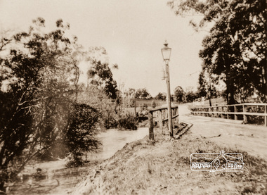
Photograph, Diamond Creek Bridge, Eltham North, c.1920
... By the end of World War I, local Victorian councils rapidly phased out acetylene infrastructure in favour of safer, independent electric powerhouse generators. ...By the end of World War I, local Victorian councils rapidly phased out acetylene infrastructure in favour of safer, independent electric powerhouse generators. ...View looking east across the Glen Park Bridge and the railway crossing towards Main Road circa 1920. The bridge was originally built as a replacement for an older private bridge built by a man named Foley around 1880. In 1911 Heidelberg and Eltham agreed to share the costs to build a new bridge (the Diamond Creek was the border between the two). Construction began in June 1915 and it was officially opened by Cr. Taylor on Cup Day, November 1915. This photo, dated around 1920, is of the Glen Park Bridge crossing over the Diamond Creek about 50 metres north of the present-day Wattletree tree Road Bridge. Glen Park Road intersected Main Rain Road along an alignment following present day Coleman Cresent. In this this picture we see the narrow wooden bridge over a high flowing Diamond Creek at Glen Park, now Eltham North. In the background is a railway crossing sign. There is a self-contained carbide streetlamp situated in front of the bridge. In the early 1900s, carbide (acetylene gas) streetlamps emerged as a lighting technology for regional towns across Victoria, Australia, before municipal electricity grids were widely established. During the late Victorian and early Edwardian eras, major hubs like Melbourne relied on centralized coal-gas infrastructure. However, small regional Victorian shires lacked the funds or population density to build large gasworks. When the commercial production of calcium carbide became viable around 1900, it offered a quantum leap in brightness over traditional kerosene streetlamps. Acetylene gas burned with an intense, crisp white flame—significantly brighter than oil or candles. Many rural towns used self-contained lampposts. A lamplighter had to climb each post daily to manually place calcium carbide pellets in a lower chamber and fill an upper chamber with water. The water dripped onto the carbide, producing acetylene gas to feed the burner. Lamplighters carefully measured the fuel amounts so the chemical reaction would naturally exhaust itself and "turn off" around midnight. While carbide streetlights provided unparalleled visibility for early motorists, cyclists, and pedestrians, they were incredibly labour-intensive and inherently volatile. The gas was highly explosive, prone to leaks, and left behind a pungent, sulphur-like odour. By the end of World War I, local Victorian councils rapidly phased out acetylene infrastructure in favour of safer, independent electric powerhouse generators. In the context of Eltham's local history, the Eltham Shire and surrounding Yarra Valley region actively relied on carbide streetlamps and kerosene lighting during the early 20th century before the expansion of the Melbourne electric grid. Eltham was an outer-rural, heavily timbered farming and orchard district at the turn of the century, it faced unique civic infrastructure challenges. In rural Eltham, early streetlamps were exceptionally sparse. The community relied heavily on "innkeeper laws" which dictated local hotels—such as the historic Eltham Hotel—were legally required to keep external oil, kerosene, or acetylene lamps burning through the night to illuminate the main roads for travellers and coaches. The volatile carbide and kerosene lamps on Eltham's main thoroughfares were progressively phased out during the 1920s. The district steadily transitioned to electricity, which allowed for developments like the installation of modern electrical wiring at the local fire station on Arthur Street by 1928. The Glen Park Bridge was a low structure and subject to flooding readily. In 1959 Eltham Council erected a new crossing over the Diamond Creek and realigned the road to the present-day Wattletree Road Bridge. Construction was not fully complete when on Sunday, 20 September 1959, heavy flooding occurred in the stream and at 3:53 pm the old bridge was washed away forever.Photograph copy eltham north, wattletree road, coleman crescent, bridges, diamond creek (creek), bridge, carbide streetlamp, floodwater, glen park bridge, street lamp, glen park road, glen park estate -
 Melbourne Tram Museum
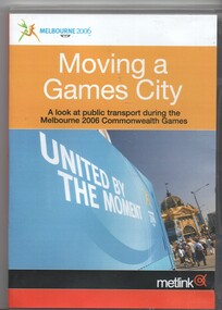
Film - Compact Diskette with video, Metlink, "Moving a Games City", 2006
... Features various elements of public transport access during the games, how they coped made changes, planning, Richmond station, Flinders St station, use of buses, passenger flows at Richmond, opening event, Ballarat station, VLine services, Doncaster Park and Ride and buses, Southbank depot, depot run outs, the Yarra Trams Fleet operations centre, Aquatic centre tram stops, St Kilda station, Southern Cross station, a very short segment of Z81, information campaigns, Metlink call centre, Rob Barnett of VLine, Dennis Cliche of Yarra trams, Peter Gibson of VLine, Digby Drew of Yarra Trams, John Stanley of BusVic, Mark Whitehead of VLine, Bernie Carolan of Metlink, Scott Martin of Dept. of Infrastructure, VLine, Mary Dimovski of Metlink, Andrew Kyriacou of Connex, Bruce Hughes of Connex....Features various elements of public transport access during the games, how they coped made changes, planning, Richmond station, Flinders St station, use of buses, passenger flows at Richmond, opening event, Ballarat station, VLine services, Doncaster Park and Ride and buses, Southbank depot, depot run outs, the Yarra Trams Fleet operations centre, Aquatic centre tram stops, St Kilda station, Southern Cross station, a very short segment of Z81, information campaigns, Metlink call centre, Rob Barnett of VLine, Dennis Cliche of Yarra trams, Peter Gibson of VLine, Digby Drew of Yarra Trams, John Stanley of BusVic, Mark Whitehead of VLine, Bernie Carolan of Metlink, Scott Martin of Dept. of Infrastructure, VLine, Mary Dimovski of Metlink, Andrew Kyriacou of Connex, Bruce Hughes of Connex. ...DVD, with large format clear plastic cover with paper insert titled "Moving a Games City", sub-titled "A look at public transport during the Melbourne 2006 Commonwealth Games". Produced by Metlink, running time 17mins, has the games logo, Metlink., Yarra Trams, Connex, BusVic, VLine and Victorian Government logos on the rear. Features various elements of public transport access during the games, how they coped made changes, planning, Richmond station, Flinders St station, use of buses, passenger flows at Richmond, opening event, Ballarat station, VLine services, Doncaster Park and Ride and buses, Southbank depot, depot run outs, the Yarra Trams Fleet operations centre, Aquatic centre tram stops, St Kilda station, Southern Cross station, a very short segment of Z81, information campaigns, Metlink call centre, Rob Barnett of VLine, Dennis Cliche of Yarra trams, Peter Gibson of VLine, Digby Drew of Yarra Trams, John Stanley of BusVic, Mark Whitehead of VLine, Bernie Carolan of Metlink, Scott Martin of Dept. of Infrastructure, VLine, Mary Dimovski of Metlink, Andrew Kyriacou of Connex, Bruce Hughes of Connex.trams, tramways, commonwealth games, yarra trams, passenger services, metlink, connex, vline -
 National Vietnam Veterans Museum (NVVM)
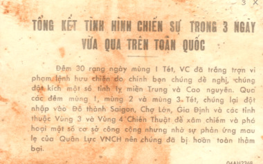
Pamphlet, A Summary of the War Situation in the country over the past days
... They have also attacked in the provinces of the 3rd and the 4th Tactical Zones to destroy infrastructure and public utilities. However, thanks to the rapid reaction of the Republic of Vietnam Armed Forces, they have been completely and humiliatingly defeated. (1968) On the reverse side reads: Herewith are the casualty rates of us and the enemy: Period: 30-01-68 - Our causalities 282 killed and wounded. ...They have also attacked in the provinces of the 3rd and the 4th Tactical Zones to destroy infrastructure and public utilities. However, thanks to the rapid reaction of the Republic of Vietnam Armed Forces, they have been completely and humiliatingly defeated. (1968) On the reverse side reads: Herewith are the casualty rates of us and the enemy: Period: 30-01-68 - Our causalities 282 killed and wounded. ...From the 30th to the 1st day of Tet (Lunar New Year), the VC have shamelessly violated the truce that they themselves proposed. The have attacked a number of town in Central Vietnam and in the Highlands. On the nights of the 1st, 2nd, and 3rd of Tet, they have taken advantage to infiltrate into the capital, Saigon - and into Gia Dinh and Cho Lon. They have also attacked in the provinces of the 3rd and the 4th Tactical Zones to destroy infrastructure and public utilities. However, thanks to the rapid reaction of the Republic of Vietnam Armed Forces, they have been completely and humiliatingly defeated. (1968) On the reverse side reads: Herewith are the casualty rates of us and the enemy: Period: 30-01-68 - Our causalities 282 killed and wounded. Enemy 2,338 killed on the spot, 182 captured. Period 1-02-68 - Our soldiers: 203 killed and wounded. Enemy 2,617 killed, 198 captured. Period 2-02-68 to 12 midday: Our soldiers 211 killed and wounded. enemy 2,112 killed, 119 captured. Summary: Our casualties: 706, Enemy casualties 7,561. Enemy weapons captured: 144 crew-served weapon; 2,253 individual weapons.TONG KET TINH HINH CHIEN SU TRON 3 NGAY - VUA QUA TREN TOAN QUOC - A Summary of the war situation in the country over the past days: On one side there is information in Vietnamese and on the reverse side the information is in a table format.pamphlet, psycological warfare, propaganda, nva/vc, viet cong, 7th battalion, 1st battalion, the royal australian regiment, terry michael collie, 2790361, lunar new year, central vietnam, saigon, gia dinh, cho lon -
 Puffing Billy Railway
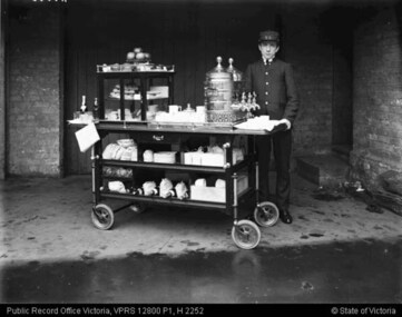
Equipment - Refreshments services Trolley, 1990s
... Its scope expanded to include diverse activities such as stall rental; sales of advertising space on railways infrastructure; laundry services; operation of a hair-dressing salon, a bakery, a butchery and a poultry farm; and the management of the chalet guesthouse at Mt Buffalo. ...Its scope expanded to include diverse activities such as stall rental; sales of advertising space on railways infrastructure; laundry services; operation of a hair-dressing salon, a bakery, a butchery and a poultry farm; and the management of the chalet guesthouse at Mt Buffalo. ...The Refreshment Services Branch was established in 1920, and initially focused on providing station-based refreshment rooms and the dining car service. Its scope expanded to include diverse activities such as stall rental; sales of advertising space on railways infrastructure; laundry services; operation of a hair-dressing salon, a bakery, a butchery and a poultry farm; and the management of the chalet guesthouse at Mt Buffalo. The majority of staff worked in refreshment rooms and dining cars, both of which were a popular feature of the railway service. Previous to 1920 refreshment services had been provided by contractors, but after many complaints the Department decided to provide a standardised service across the system. It grew quickly: five years after it was established the Branch employed approximately 500 staff. Station refreshment facilities ranged from elaborate dining rooms to decorated push-carts. They were staffed predominately by women, who provided everything from a cup of tea to a three course meal. Most refreshment room services were closed in the 1970s. Reference from : Fielding, K. (2012) Victorian Railways - Refreshment Services Branch in Museums Victoria Collections http://collections.museumvictoria.com.au/articles/11470Historic - Replica of a a Victorian Railways Refreshment Services Serving Trolley used on Puffing Billy Railway Replica large wooden serving cart with fitted wooden cabinet featuring sliding glass doors and one glass shelf. Cart has chrome handles, two wooden shelves, a wooden drawer with chrome handle and a small chalkboard adhered to end. Cart has four small black rubber and metal wheels and a metal foot brake.puffing billy, serving trolley, replica, dining cart, refreshment services, victorian railways -
 Eltham District Historical Society Inc
Album - Photograph, J.A. McDonald, Eltham-Diamond Creek Road, 21 Oct. 1953
... Infrastructure...In many situations, the photos provide a tangible visible record of infrastructure that existed throughout the early days of the Shire. ...18 October 1956 Proposed upstream line over Diamond Creek from Diamond Creek sideRecord of various Shire of Eltham infrastructure works undertaken during the period of 1952-1962 involving bridge and road reconstruction projects, sometimes with Eltham Shire Council Project Reference numbers quoted. It was during this period that a number of significant improvements were made to roads and new bridges constructed within the shire that remain in place as of present day (2022). In many situations, the photos provide a tangible visible record of infrastructure that existed throughout the early days of the Shire. The album was put together by or under the direction of the Shire Engineer, J.A. McDonald.infrastructure, road construction, shire of eltham, bridge construction, eltham north, floods, floodwater, glen park bridge, 1956-10-18, diamond creek (creek), eltham, railway parade, wattletree road, wattletree road bridge -
 Eltham District Historical Society Inc
Album - Photograph, J.A. McDonald, Eltham-Diamond Creek Road, 21 Oct. 1953
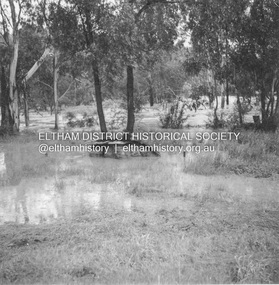
... Infrastructure...In many situations, the photos provide a tangible visible record of infrastructure that existed throughout the early days of the Shire. ...18 October 1956 Flooding on downstream line from Diamond Creek sideRecord of various Shire of Eltham infrastructure works undertaken during the period of 1952-1962 involving bridge and road reconstruction projects, sometimes with Eltham Shire Council Project Reference numbers quoted. It was during this period that a number of significant improvements were made to roads and new bridges constructed within the shire that remain in place as of present day (2022). In many situations, the photos provide a tangible visible record of infrastructure that existed throughout the early days of the Shire. The album was put together by or under the direction of the Shire Engineer, J.A. McDonald.infrastructure, road construction, shire of eltham, bridge construction, eltham north, floods, floodwater, glen park bridge, 1956-10-18, diamond creek (creek), eltham, railway parade, wattletree road, wattletree road bridge -
 Eltham District Historical Society Inc
Album - Photograph, J.A. McDonald, Eltham-Diamond Creek Road, 21 Oct. 1953
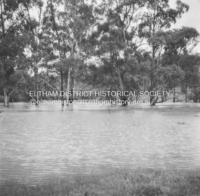
... Infrastructure...In many situations, the photos provide a tangible visible record of infrastructure that existed throughout the early days of the Shire. ...18 October 1956 New downstream alignment from Eltham sideRecord of various Shire of Eltham infrastructure works undertaken during the period of 1952-1962 involving bridge and road reconstruction projects, sometimes with Eltham Shire Council Project Reference numbers quoted. It was during this period that a number of significant improvements were made to roads and new bridges constructed within the shire that remain in place as of present day (2022). In many situations, the photos provide a tangible visible record of infrastructure that existed throughout the early days of the Shire. The album was put together by or under the direction of the Shire Engineer, J.A. McDonald.infrastructure, road construction, shire of eltham, bridge construction, eltham north, floods, floodwater, glen park bridge, 1956-10-18, diamond creek (creek), eltham, railway parade, wattletree road, wattletree road bridge -
 Eltham District Historical Society Inc
Album - Photograph, J.A. McDonald, Eltham-Diamond Creek Road, 21 Oct. 1953
... Infrastructure...In many situations, the photos provide a tangible visible record of infrastructure that existed throughout the early days of the Shire. ...18 October 1956 Proposed upstream line from Eltham sideRecord of various Shire of Eltham infrastructure works undertaken during the period of 1952-1962 involving bridge and road reconstruction projects, sometimes with Eltham Shire Council Project Reference numbers quoted. It was during this period that a number of significant improvements were made to roads and new bridges constructed within the shire that remain in place as of present day (2022). In many situations, the photos provide a tangible visible record of infrastructure that existed throughout the early days of the Shire. The album was put together by or under the direction of the Shire Engineer, J.A. McDonald.infrastructure, road construction, shire of eltham, bridge construction, eltham north, floods, floodwater, glen park bridge, 1956-10-18, diamond creek (creek), eltham, railway parade, wattletree road, wattletree road bridge -
 Eltham District Historical Society Inc
Album - Photograph, J.A. McDonald, Eltham-Greensborough Road, 18 Oct. 1956
... Infrastructure...In many situations, the photos provide a tangible visible record of infrastructure that existed throughout the early days of the Shire. ...Bridge Street Bridge Flooding on Waterfall’s Estate 18th October 1956 Looking east up to Main Road over what is now present-day Alistair Knox Park Beware!.. our rivers are rising (1956, October 19). The Argus (Melbourne, Vic. : 1848 - 1957), p. 1. Retrieved August 24, 2022, from http://nla.gov.au/nla.news-article84392304Record of various Shire of Eltham infrastructure works undertaken during the period of 1952-1962 involving bridge and road reconstruction projects, sometimes with Eltham Shire Council Project Reference numbers quoted. It was during this period that a number of significant improvements were made to roads and new bridges constructed within the shire that remain in place as of present day (2022). In many situations, the photos provide a tangible visible record of infrastructure that existed throughout the early days of the Shire. The album was put together by or under the direction of the Shire Engineer, J.A. McDonald.infrastructure, road construction, shire of eltham, bridge construction, bridge street bridge, eltham, eltham-greensborough road, 1956-10-18, diamond creek (creek), floods, floodwater, silver street bridge, alistair knox park, waterfall property -
 Eltham District Historical Society Inc
Slide - Photograph, Aerial Photo (c.1987): Main Road, Eltham from Pitt Street to Elsa Court, c.Aug. 1990
... infrastructure...In the byways category are views of some iof the Shire's bicycle paths including then recently completed sections of the Main Yarra Trail at Lower Plenty. infrastructure roads Aerial photographs Alistair Knox Park Bridge Street Central Park Diamond Street Elsa Court Eltham Eltham Common Eltham Railway Station Eltham Town Park Main Road Pitt Street 35mm colour positive transparency (1 of 37) Mount - Agfachrome Agfa CS System black 8 dots Aerial Photo (c.1987): Main Road, Eltham from Pitt Street to Elsa Court Slide Photograph ...Part of a presentation, "Roads and Byways of the Shire of Eltham", by Russell Yeoman to the 12 September 1990 Society meeting. Slides shown included copies of old photos and recent images ranging from the suburban streets of Eltham and Montmorency to the mountain roads of Kinglake. In the byways category are views of some iof the Shire's bicycle paths including then recently completed sections of the Main Yarra Trail at Lower Plenty.35mm colour positive transparency (1 of 37) Mount - Agfachrome Agfa CS System black 8 dotsinfrastructure, roads, aerial photographs, alistair knox park, bridge street, central park, diamond street, elsa court, eltham, eltham common, eltham railway station, eltham town park, main road, pitt street -
 Bendigo Historical Society Inc.
Document - History Notes - Information on Mining, statistics and early development of Bendigo, 1840-1990 approx
... Key Events: Establishment of hospital, police court, churches, schools, and infrastructure like railways and water supply.Governance and Civic Structure. ...Key Events: Establishment of hospital, police court, churches, schools, and infrastructure like railways and water supply.Governance and Civic Structure. ...Saddle, Fault, and Spur reefs are the main types, found in Ordovician slates and sandstones folded into anticlines and synclines. Major Productive Reefs: Hustlers, Garden Gully, Paddy's Gully, Sheepshead, New Chum, Nell Gwynne, and Carshalton.Mining Process: Gold is found in quartz lodes, extracted, crushed, and separated using mercury amalgamation. From 1851–1949, over 21 million ounces of gold were produced, valued at approximately £323 million (1964 prices). Located Bendigo is in central Victoria, north of the Dividing Range, between Campaspe Valley and Loddon flats; 100 miles from Melbourne. The City area is 8,030 acres; population around 40,000 (city), 47,000 (district).Climate is temperate, with average rainfall of 20 inches, and 320 sunny days per year. Gold First discovered in 1851 at Golden Square. Bendigo Became a municipal district in 1855, a town in 1861, a city in 1871, and changed its name from Sandhurst to Bendigo in 1891. Key Events: Establishment of hospital, police court, churches, schools, and infrastructure like railways and water supply.Governance and Civic Structure. Council Structure: 3 wards, each with 3 councillors serving 3-year terms; mayor elected by councillors. Main revenue from rates and property; principal duties include public works, health, parks, and enforcement of by-laws. Major Projects: Olympic swimming pool, market extensions, park improvements, road and drainage works.Economy and IndustryCommerce: 730 retail shops, 260 factories, and a major livestock market.Principal Industries: Meat processing, manufacturing (including ordnance, textiles, engineering), fruit and food processing, and egg production. Bendigo is Noted for sheep, lamb, fruit (especially tomatoes and apples), and dairy. Major rail and road hub with connections across Victoria and to New South Wales; tram and bus services.Education: Institute of Technology, Teachers College, multiple secondary and primary schools, and special education facilities. Several hospitals, aged care homes, and health services. 486 acres of parks and gardens, extensive sports facilities, and Lake Eppalock for water sports. Wide range of community, cultural, and sporting organizations. Regional library, art gallery, music and drama societies. Notable Figures and HeritageGeorge Lansell: Known as the "Gold King," a key figure in Bendigo's mining history. Transformation: From a sheep run to a major goldfield and then to a modern city with significant infrastructure and cultural assets. Motto Coat of Arms: Features symbols representing gold mining, agriculture, pioneering, and fruit growing.Motto: "Progress" in gold on a purple ribbon.Bendigo's history is marked by rapid growth from gold discovery, strong civic development, and a diverse economy, making it a significant regional center in Victoria.History Notes - Information on Mining, statistics and early development of Bendigo - author unknown This item contains the following document: 11217.65a Twelve Foolscap typed pages with information on Bendigonon-fictionbendigo, fortuna, george lansell, development of bendigo -
 Melbourne Tram Museum
Newspaper, The Age, "Discrimination bid on historic trams", "Tram delays leave disable behind", 6/11/2006 12:00:00 AM
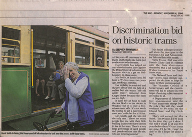
... Series of four newspaper cuttings about discrimination access to trams and wheel chair users. .1 - The Age 6/11/2006 - "Discrimination bid on historic trams" - about Hazel Smith taking Dept of Infrastructure to court about the use of W class trams on the route 78 line. ...Melbourne Tram Museum 8 Wallen Road Hawthorn melbourne Trams tramways Melbourne Tramways Disability services DOI Route 78 Route 96 Superstops Series of four newspaper cuttings about discrimination access to trams and wheel chair users. .1 - The Age 6/11/2006 - "Discrimination bid on historic trams" - about Hazel Smith taking Dept of Infrastructure to court about the use of W class trams on the route 78 line. ...Series of four newspaper cuttings about discrimination access to trams and wheel chair users. .1 - The Age 6/11/2006 - "Discrimination bid on historic trams" - about Hazel Smith taking Dept of Infrastructure to court about the use of W class trams on the route 78 line. Notes she had a fall on this tram and suffered injuries. Has comments from the Dept and Yarra Trams. .2 - The Age? undated c2012 - "Tram delays leave disable behind" about the lack of progress in making trams more accessible, Australian Human Rights Commission, Transport, Minister Lynne Kosky and quotes from a wheel chair user, John McKenna and Vic Council of Social Services Cath Smith. .3 - The Age? - undated c2013 - Next trams years away for disabled travellers - similar issues - has a photo of Wendy Brooks in her wheelchair near the Royal Melbourne Hospital. .4 - The Age 10/5/2018 - "Tram traps: wheels not welcome" - looking at disability access tram stops, routes access and the cast of James Carter missing a stop and not able to get off until the tram returned. Has a map of route 96. Also quotes Daniel Bowen of the PTUA and Human Rights Commission.trams, tramways, melbourne, tramways, disability services, doi, route 78, route 96, superstops -
 The Beechworth Burke Museum
Audio - Oral History, Jennifer Williams, Mrs Val Mason, 5 January 2001
... Concerned with improving infrastructure and developing economic opportunities in the region, Mrs. ...Concerned with improving infrastructure and developing economic opportunities in the region, Mrs. ...Mrs. Valerie (Val) Mason (1927-2019) was a local sheep farmer, business-woman, Beechworth shire councillor, and mother to five children. With her husband, Charles, Mrs. Mason developed and managed the Big Valley farm estate, at Everton, which is now part of a vineyard and farm stay. Mrs. Mason was instrumental in introducing a 'paddock to plate' philosophy and business model, opening a butcher shop on the farm in 1973. Concerned with improving infrastructure and developing economic opportunities in the region, Mrs. Mason successfully stood as a local council representative for South Riding in the United Shire of Beechworth, and later become the first woman Shire President in 1979. Mrs Mason was a member of the local Business and Professional Women's Club for 37 years. This oral history recording was part of a project conducted by Jennifer Williams in the year 2000 to capture the everyday life and struggles in Beechworth during the twentieth century. This project involved recording seventy oral histories on cassette tapes of local Beechworth residents which were then published in a book titled: 'Listen to what they say: voices of twentieth century Beechworth. These cassette tapes were digitised in July 2021 with funds made available by the Friends of the Burke.Mrs. Mason's story is historically significant for understanding economic and social changes in the Beechworth region during the latter half of the twentieth century. As a council representative, issues such as road and infrastructure modernisation and the transition from traditional government employment sectors, like Beechworth's care institutions, were challenges for local government. As a farmer and local employer, Mrs. Mason's story is testimony to the region's economic diversification as businesses like Big Valley farm shop helped shape the region's contemporary character. Mrs. Mason was among the first women to broach the traditionally all-male Beechworth Council Chambers and her story is socially significant for understanding the changing role of women in rural and regional Australia. This oral history recording offers interpretive capacity for social history themes and may be compared with other oral histories in the Burke Museum's collection. This oral history account is socially and historically significant as it is a part of a broader collection of interviews conducted by Jennifer Williams which were published in the book 'Listen to what they say: voices of twentieth-century Beechworth.' While the township of Beechworth is known for its history as a gold rush town, these accounts provide a unique insight into the day-to-day life of the town's residents during the 20th century, many of which will have now been lost if they had not been preserved.This is a digital copy of a recording that was originally captured on a cassette tape. The cassette tape is black with a horizontal white strip and is currently stored in a clear flat plastic rectangular container. It holds up 40 minutes of recordings on each side.Mrs Val Mason /listen to what they say, beechworth, oral history, burke museum, working women, trail blazers, farm to plate, farm shop, paddock to plate, woman farmer, united shire of beechworth, rural and regional women, beechworth's first woman shire president, women in leadership positions, women leaders, australian settlement history, settler societies, victorian gold rush, heritage tourism, culinary tourism, regional land use, indigo winery, farm stay, social history -
 Mission to Seafarers Victoria
Artwork, other - Art installation, Dagmar Udhe, Leap of the Heart: Ultramarine perspex oval shape by Dagmar Udhe, 1998
... And with this agenda in mind, their events affirm the active participation of international artists with local infrastructure and site specific materials. The organisation of the 1998 CIP in Melbourne, titled "The Bridge", took Richard Thomas, Katherine Armstrong, Gail Davidson and the legion of others over two years of dedication. ...And with this agenda in mind, their events affirm the active participation of international artists with local infrastructure and site specific materials. The organisation of the 1998 CIP in Melbourne, titled "The Bridge", took Richard Thomas, Katherine Armstrong, Gail Davidson and the legion of others over two years of dedication. ...See document 1507Information for the brochure (http://www.artdes.monash.edu.au/globe/issue8/tbtitle.html) Construction in Process VI The Bridge, Melbourne Event: March 21-31 1998 Exhibition April 1-30 1998 During Construction in Process (CIP) III at Lodz, Poland in 1991, Emmett Williams and other participating artists initiated the idea of a biannual "performance" of their project in different cities and sites around the world. In the first instance, CIP was a response to the strictures of museum contained commodification of art practices and the dissolution of communism. And with this agenda in mind, their events affirm the active participation of international artists with local infrastructure and site specific materials. The organisation of the 1998 CIP in Melbourne, titled "The Bridge", took Richard Thomas, Katherine Armstrong, Gail Davidson and the legion of others over two years of dedication. And they brought off one of the most open-ended, logistically challenging conceptual events this metropolis has witnessed. The following photo essay provides a personal survey of the "The Bridge", as I saw it transpire around me. German artist Dagmar Udhe created several art installation in Swanson Dock and the Mission. This plaque was placed either in the dome or outside the dome. It may have been forgotten or left intentionally by the artist.PerformanceUltramarine ovoid shaped perspex plaque attached to the wall in the entrance of the Mission (Flinders Street).art installation, dagmar udhe, cultural events, artwork-paintings -
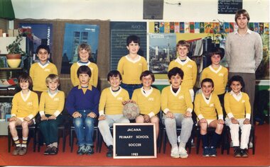 Broadmeadows Historical Society & Museum
Photograph - Team Photograph, Jacana Primary School: Soccer Team 1983
... The post-war era saw significant investment in public infrastructure, including schools, to support growing communities shaped by migration and housing expansion. ...The post-war era saw significant investment in public infrastructure, including schools, to support growing communities shaped by migration and housing expansion. ...Jacana Primary School was established in 1959 during a period of rapid suburban development in Melbourne’s northern suburbs. The post-war era saw significant investment in public infrastructure, including schools, to support growing communities shaped by migration and housing expansion. Jacana, located near Broadmeadows, became home to many working-class families, including newly arrived migrants, contributing to a rich and diverse social fabric. By the early 1980s, schools like Jacana Primary were not only centres of education but also vital community hubs. Sporting activities, particularly team sports like soccer, played a central role in student life. They promoted physical health, teamwork, and social inclusion, while also reflecting broader cultural influences—especially as soccer gained popularity among migrant communities. The 1983 soccer team photograph captures this dynamic period, showcasing the importance of extracurricular activities in fostering school spirit and community engagement. It also reflects the values of public education at the time: equity, participation, and the celebration of diversity. Such images serve as enduring records of how schools contributed to shaping local identity and cohesion during a transformative era in Melbourne’s suburban history. This 1983 colour photograph of Jacana Primary School’s soccer team captures the energy and camaraderie of a school that served as a cornerstone of its community from 1959 until its closure in the early 2000s. More than a simple team portrait, the image reflects the vibrant sporting culture that was integral to student life and community engagement during the early 1980s. The photograph preserves cherished memories of teamwork, school pride, and youthful enthusiasm, offering insight into the social dynamics and extracurricular values of the time. It stands as a visual testament to the role of sport in fostering inclusion, resilience, and a sense of belonging among students—qualities that defined Jacana Primary’s enduring legacy in Melbourne’s northern suburbs.A colour photograph of a school Soccer team on satin finish photo paper.PH-4465 (white label) Top Left Corner PH-5431(blue label) Top Right Corner Manufactures mark; Fujicolor/ Paperjacana primary school, photograph, school photograph, education, soccer team, 1983 -
 Broadmeadows Historical Society & Museum
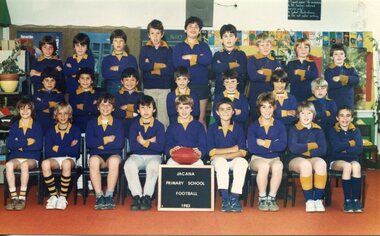
Photograph - Team Photograph, Jacana Primary School: Football Team 1983
... Jacana Primary School, founded in 1959 amid the rapid suburban expansion of Melbourne’s northern corridor, emerged during a time of significant public investment in education and infrastructure. Located near Broadmeadows, the school served a growing population of working-class families, many of whom were newly arrived migrants. ...Broadmeadows Historical Society & Museum 21 Pearcedale Parade Broadmeadows melbourne Jacana Primary School, founded in 1959 amid the rapid suburban expansion of Melbourne’s northern corridor, emerged during a time of significant public investment in education and infrastructure. Located near Broadmeadows, the school served a growing population of working-class families, many of whom were newly arrived migrants. ...Jacana Primary School, founded in 1959 amid the rapid suburban expansion of Melbourne’s northern corridor, emerged during a time of significant public investment in education and infrastructure. Located near Broadmeadows, the school served a growing population of working-class families, many of whom were newly arrived migrants. This diverse community shaped the school’s inclusive and multicultural character. By the early 1980s, Jacana Primary had become more than just a place of learning—it was a central hub for community life. Team sports, particularly football, played a vital role in the daily rhythm of the school. Football’s growing popularity, especially among migrant communities, made it a natural fit for fostering teamwork, physical fitness, and social connection among students. The 1983 football team photograph captures this vibrant period in the school’s history. It reflects the importance of extracurricular activities in promoting school spirit, cultural exchange, and community engagement. The image also embodies the values of public education at the time: equity, participation, and the celebration of diversity. As part of Jacana Primary’s visual archive, it stands as a lasting record of how schools helped shape local identity and cohesion during a transformative era in Melbourne’s suburban development. This photograph of Jacana Primary School’s 1983 football team is a significant historical record that reflects the social and cultural dynamics of Melbourne’s northern suburbs during a period of rapid suburban growth and demographic change. Taken at a time when schools were central to community life, the image captures the role of sport, particularly football, fostering inclusion, teamwork, and school pride. The photograph is especially meaningful within the context of Jacana’s diverse student population, shaped by post-war migration and working-class settlement. Soccer, a sport embraced by many migrant communities, served as a unifying activity that transcended language and cultural barriers. It provided students with a sense of belonging and identity, while also promoting physical health and social development. As part of Jacana Primary School’s visual archive, this image contributes to a broader understanding of how public education supported multicultural integration and community cohesion in late 20th-century Victoria. It stands as a testament to the enduring value of extracurricular programs in shaping student experiences and strengthening the social fabric of local neighbourhoods. A colour photograph on matte finish photo paper.PH-5431(blue label) Top left Corner Manufactures mark; Fujicolor/ Paperjacana primary school, photograph, school photograph, education, 1983, football -
 Wodonga & District Historical Society Inc
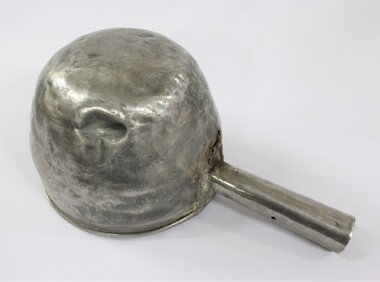
Functional object - Sand Scoop, North East Region Water Authority, Wodonga
... In 1923 a Wodonga Waterworks Trust referendum to provide funding for new infrastructure to supply more water of better quality to Wodonga was passed. ...In 1923 a Wodonga Waterworks Trust referendum to provide funding for new infrastructure to supply more water of better quality to Wodonga was passed. ...The large aluminium sand scoop was used by Wodonga Waterworks Trust and it is part of the North East Region Water Authority collection in the Wodonga Historical Society. Wodonga's drinking water and wastewater operations were originally managed by the Wodonga Waterworks Trust, which was established in 1897, after Wodonga became a separate shire in 1876. In 1923 a Wodonga Waterworks Trust referendum to provide funding for new infrastructure to supply more water of better quality to Wodonga was passed. This included building the Wodonga Water Tower and it was completed in 1924. It supplied water to Wodonga until 1959, when it was drained and decommissioned after the No 1 Basin on Huon Hill was completed in 1958. In 1983 the Wodonga Waterworks Trust and the Wodonga Sewerage Authority became part of the Wodonga Council. And by 1989 a filtration plant at Huon Hill was completed, which provided filtered water of improved quality to Wodonga, in accordance with the World Health Organisation’s guidelines. In 1994 the Kiewa Murray Region Water Authority took over the Wodonga Council’s water and wastewater operations, and then in 1999 the Kiewa Murray Region Water Authority combined with the Ovens Region Water Authority and became the North East Region Water Authority or NERWA. NERWA then became known as North East Water. The sand scoop has local significance as part of the North East Region Water Authority collection donated to the Wodonga Historical Society. It also has wider state significance as a rare example of the equipment used in water management in Wodonga.Large aluminium scoop with a handle soldered on one side edge and a repair riveted to the interior surface of the scoop where the handle is located. The repair is a piece of sheet metal, with what looks like the lower part of the letter 'S' on it.Lower part of the letter "S" on the repair riveted to the interior surface of the scoop.north east region water authority, nerwa, wodonga waterworks trust, north east water, n.e. water, kiewa murray region water authority, metal scoop, sand scoop -
 Wodonga & District Historical Society Inc
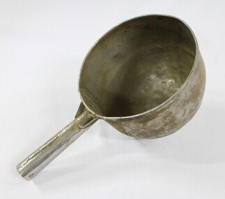
Functional object - Sand Scoop, North East Region Water Authority, Wodonga
... In 1923 a Wodonga Waterworks Trust referendum to provide funding for new infrastructure to supply more water of better quality to Wodonga was passed. ...In 1923 a Wodonga Waterworks Trust referendum to provide funding for new infrastructure to supply more water of better quality to Wodonga was passed. ...The large aluminium sand scoop was used by Wodonga Waterworks Trust and it is part of the North East Region Water Authority collection in the Wodonga Historical Society. Wodonga's drinking water and wastewater were originally managed by the Wodonga Waterworks Trust, which was established in 1897, after Wodonga became a separate shire in 1876. In 1923 a Wodonga Waterworks Trust referendum to provide funding for new infrastructure to supply more water of better quality to Wodonga was passed. This included building the Wodonga Water Tower and it was completed in 1924. It supplied water to Wodonga until 1959, when it was drained and decommissioned after the No 1 Basin on Huon Hill was completed in 1958. In 1983 the Wodonga Waterworks Trust and the Wodonga Sewerage Authority became part of the Wodonga Council, and by 1989 a filtration plant at Huon Hill was completed, which provided filtered water of improved quality to Wodonga, in accordance with the World Health Organisation’s guidelines. In 1994 the Kiewa Murray Region Water Authority took over the Wodonga Council’s water and wastewater operations, and then in 1999 the Kiewa Murray Region Water Authority combined with the Ovens Region Water Authority and became the North East Region Water Authority or NERWA. NERWA then became known as North East Water. The sand scoop has local significance as part of the North East Region Water Authority collection donated to the Wodonga Historical Society. It also has wider state significance as a rare example of the equipment used in water management in Wodonga.Large aluminium scoop with a handle soldered on one side edge. Two holes and one indent in the end of the handle.north east region water authority, nerwa, wodonga waterworks trust, north east water, n.e. water, kiewa murray region water authority, sand scoop, metal scoop -
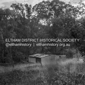 Eltham District Historical Society Inc
Negative - Photograph, J.A. McDonald, Road Reserve Housing, Mar. 1961
... Infrastructure...In many situations, the photos provide a tangible visible record of infrastructure that existed throughout the early days of the Shire. ...Shack built on road reserve without permit Most probably up on Simms Road, Kinglake Other areas where illegal shacks were built wer at the junction of Flat Rock Road and Cherry Tree Road, Hurstbridge. At times, Building Surveyor George E Newton would have to attend to these shacks for inspection and issue demolition ordersRecord of various Shire of Eltham infrastructure works undertaken during the period of 1952-1962 involving bridge and road reconstruction projects, sometimes with Eltham Shire Council Project Reference numbers quoted. It was during this period that a number of significant improvements were made to roads and new bridges constructed within the shire that remain in place as of present day (2022). In many situations, the photos provide a tangible visible record of infrastructure that existed throughout the early days of the Shire. The album was put together by or under the direction of the Shire Engineer, J.A. McDonald.infrastructure, shire of eltham, 1961-03, building surveyor, cherry tree road, flat rock road, george e. newton, houses, hurstbridge, kinglake, road reserve, road reserve housing, scan - 120 format 6x6 negative, shack, simms road -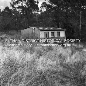
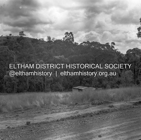 Eltham District Historical Society Inc
Negative - Photograph, J.A. McDonald, Road Reserve Housing, Mar. 1961
... Infrastructure...In many situations, the photos provide a tangible visible record of infrastructure that existed throughout the early days of the Shire. ...Shack built on road reserve without permit Most probably up on Simms Road, Kinglake Other areas where illegal shacks were built were at the junction of Flat Rock Road and Cherry Tree Road, Hurstbridge. At times, Building Surveyor George E Newton would have to attend to these shacks for inspection and issue demolition ordersRecord of various Shire of Eltham infrastructure works undertaken during the period of 1952-1962 involving bridge and road reconstruction projects, sometimes with Eltham Shire Council Project Reference numbers quoted. It was during this period that a number of significant improvements were made to roads and new bridges constructed within the shire that remain in place as of present day (2022). In many situations, the photos provide a tangible visible record of infrastructure that existed throughout the early days of the Shire. The album was put together by or under the direction of the Shire Engineer, J.A. McDonald.infrastructure, shire of eltham, 1961-03, building surveyor, cherry tree road, flat rock road, george e. newton, houses, hurstbridge, kinglake, road reserve, road reserve housing, scan - 120 format 6x6 negative, shack, simms road -
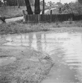 Eltham District Historical Society Inc
Album - Photograph, J.A. McDonald, Eltham-Diamond Creek Road, 21 Oct. 1953
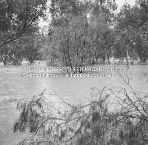
... Infrastructure...In many situations, the photos provide a tangible visible record of infrastructure that existed throughout the early days of the Shire. ...18 October 1956 Flooding on Diamond Creek 17th October 1956 (not max.) This view is looking southwest along Railway Parade (now present-day Gastons Road) past Mrs Lucy Egan's house now owned by the Bakos family, purchased by Mrs Heather Bakos in 1960Record of various Shire of Eltham infrastructure works undertaken during the period of 1952-1962 involving bridge and road reconstruction projects, sometimes with Eltham Shire Council Project Reference numbers quoted. It was during this period that a number of significant improvements were made to roads and new bridges constructed within the shire that remain in place as of present day (2022). In many situations, the photos provide a tangible visible record of infrastructure that existed throughout the early days of the Shire. The album was put together by or under the direction of the Shire Engineer, J.A. McDonald.infrastructure, road construction, shire of eltham, bridge construction, eltham north, floods, floodwater, glen park bridge, 1956-10-18, diamond creek (creek), eltham, railway parade, wattletree road, wattletree road bridge, gastons road