Showing 113078 items
matching road
-
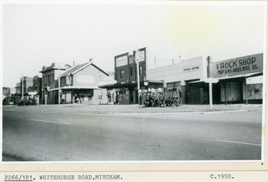 Whitehorse Historical Society Inc.
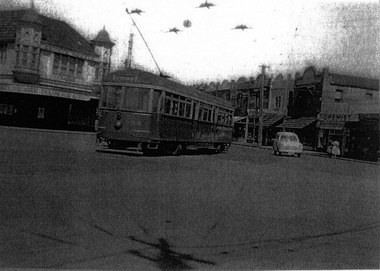
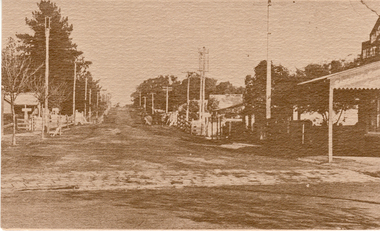
Photograph, Whitehorse Road Mitcham, C1940s-50s
Black and white photo of Shopping Centre in Whitehorse Road, Mitcham looking S.S.E.mitcham, mitcham shopping centre -
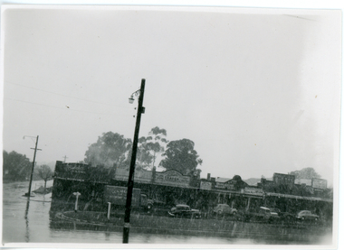 Whitehorse Historical Society Inc.
Photograph, Whitehorse Road Mitcham, 1/08/1951 12:00:00 AM
Black and white photograph of snow falling in Whitehorse Road Mitcham looking North.whitehorse road mitcham, snow falling -
 Whitehorse Historical Society Inc.
Photograph, Railway Road, Blackburn, 2012
Coloured photograph of Railway Road, looking east towards the Blackburn roundabout - 2012railway road, blackburn -
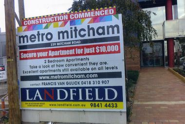 Whitehorse Historical Society Inc.
Photograph, 339 Mitcham Road, Mitcham, 2013
5 Coloured photograph (a -e) of apartments being built at 339 Mitcham Road.mitcham road, mitcham. no.339, apartments, housing -
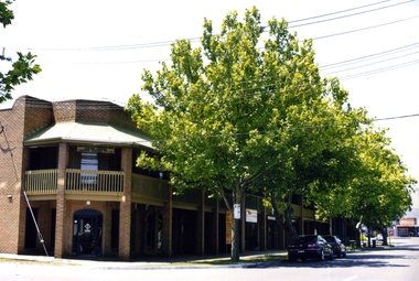
 Whitehorse Historical Society Inc.
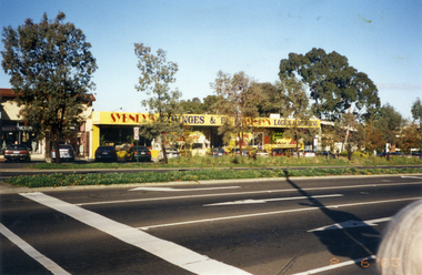
Photograph, Whitehorse Road, Mitcham
Coloured photo of Whitehorse Road, Mitcham, west of Station Street. Taken 2003whitehorse road, mitcham -
 Whitehorse Historical Society Inc.
Photograph, Quarry Road Mitcham, 2006
Coloured photo of Guarry Road bridge near boundary of Whitehorse and Manningham municipalities.quarry road, mitcham, bridges -
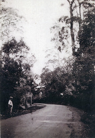 Mt Dandenong & District Historical Society Inc.
Photograph, Main Road, Kalorama, c1930
Boy standing at side of Main Road, Kalorama with sign post and house in background.kalorama, main road -
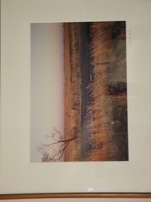 Brimbank City Council Art Collection
Photograph, Robert Pointon, West of Fitzgerald Road, 1990
Local SceneRobert Pointon. West of Fitzgerald Road. Colour photograph, 34 x 49cm -
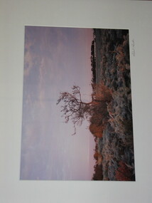 Brimbank City Council Art Collection
Photograph, Robert Pointon, East of Fairbaine Road, 1988
Local SceneRobert Pointon. East of Fairbaine Road. Colour photograph, 34 x 49cm -
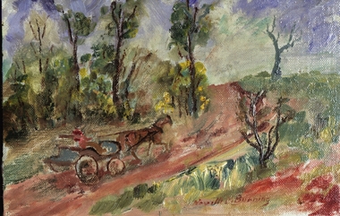 Federation University Art Collection
Oil painting, Neville Bunning, 'The Dalveen Braeside Road' by Neville Bunning
This item is part of the Federation University Art Collection. The Art Collection features over 1000 works and was listed as a 'Ballarat Treasure' in 2007.Small painting depicting horse and carriage with driver moving along a country road.Signed bottom centre Neville M Bunningart, artwork, to be framed, horse and carriage, neville bunning -
 University of Melbourne, Burnley Campus Archives
Plan, Road Diversions, 1881-1889
Sketch plan of Burnley College grounds showing road diversions in 1881 and 1889.burnley college -
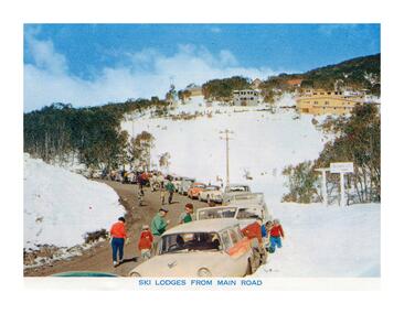 Falls Creek Historical Society
Postcard - Ski Lodges from main road
These photographs were taken in and around Falls Creek by Samuel Keith Pearce and printed for him as a foldout postcard by NuColor Vue. The postcards state they were printed for S. K. Pearce Pty. Ltd of Tawonga and Mount Beauty. Samuel Keith Pearce was born on 24 June 1917 in Armadale, Victoria. By the late 1940s he owned the Mt Beauty Supermarket, Newsagency, Drapery and Hardware store at Mount Beauty and also a store at Tawonga in partnership with his brother Gordon Cathew Pearce. For some time, they operated as Pearce Brothers. In the early 1960s Keith also opened a mini mart In Falls Creek. As well as being a keen photographer and an astute businessman, Keith Pearce was a well-known identity in the Kiewa Valley, making many contributions to the development of the area over a long period. This included serving as a member of the Bright Shire Council for many years. He worked hard to promote the interests of the Upper Kiewa Valley. As a sign of recognition and appreciation for his contribution to the community, the park opposite the grocery store in Mount Beauty was named the SK Pearce Gardens in his honour. Samuel Keith Pearce died on 7 July 1994 in Mount Beauty, VictoriaThis collection of postcards and image is significant because they were commissioned by a highly successful business in Falls Creek, Victoria.A postcard showing the view of lodges at Falls Creek taken from the main road.astra falls creek, falls creek accommodation, falls creek businesses -
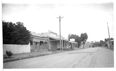 Tarnagulla History Archive
Photograph of buildings on Commercial Road, Tarnagulla, Buildings on Commercial Road, Tarnagulla, Late 1960s
Murray Comrie Collection. Burstall Hall is visible in the distant background.Monochrome photograph, streetscape. Commercial Road Tarnagulla between Poverty and Wayman Streets. tarnagulla, buildings, commercial road -
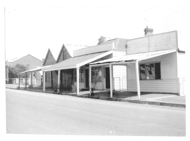 Tarnagulla History Archive
Photograph of buildings on Commercial Road, Tarnagulla, Buildings on Commercial Road, Tarnagulla, Late 1960s
Murray Comrie Collection. A good quality original print.Monochrome photograph, streetscape. Commercial Road Tarnagulla between Poverty and King Streets. tarnagulla, buildings, commercial road -
 St Kilda Historical Society
Photograph, Railway Tram, c. 1950s?
black and white photograph laminatedRailway Tram crossing Glenhuntly Road into Ormond Road -
 Melbourne Tram Museum
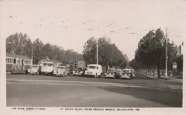
Postcard, Rose Stereograph Co, "St Kilda Road, from Princes Bridge Melbourne Vic", c1950
Postcard - Black and White - Rose Series P13352, titled "St Kilda Road, from Princes Bridge Melbourne Vic", featuring a traffic in St Kilda Road, all stopped (by a traffic policeman) at the intersection with City Road - has 7 motor vehicles all neatly stopped in a line and two tramcars (W2). Includes three black and white taxis - tow of the FJ Holden type. The City Road tram tracks are in the foreground. On the rear - has a divided back, and "A Real Photograph" " & Produced in Australia".On the rear has the stamp of Graeme S Breydon - see image i2.trams, tramways, melbourne, princes bridge, st kilda rd, city rd -
 Melbourne Tram Museum
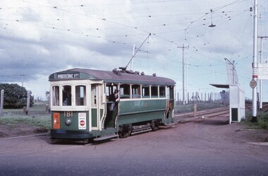
Photograph - Digital Image, T class 181 in Wests Road Maribyrnong, 1950's
Digital image of T class 181 in Wests Road Maribyrnong at the junction with Raleigh Road and Cordite Ave. The destination sign set at Pyrotechnic Factory with is behind the tram at the Williamston Road terminus. It shows a former connection that allowed trams from Williamson Road to turn to go the Explosives Factory. The Essendon Drive In theatre screen is behind the tram. Photo used in a detailed article on the Wartime tramways that appeared in the June 2018 issue of Bellcord. Photo provided Ron Scholten from his slide collection.trams, tramways, west maribyrnong, world war 2, t class, explosives factory, t class, pyrotechnic factory, tram 181 -
 The Beechworth Burke Museum Research Collection
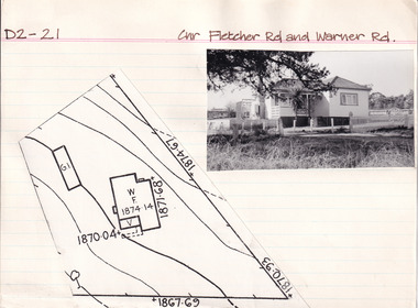
Card (Series) - Index Card, George Tibbits, Cnr Fletcher Road and Warner Road, Beechworth, 1976
George Tibbits, University of Melbourne. Faculty of Architecture, Building and Town & Regional PlanningIndex system that support the research for Beechworth : historical reconstruction / [by] George Tibbits ... [et al]Arranged by street names of BeechworthEach index card includes: street name and number of property, image of property, allotment and section number, property owners and dates of ownership, description of the property according to rate records, property floor plan with dimensions.beechworth, george tibbitsbeechworth, george tibbits -
Whitehorse Historical Society Inc.
Map, Burwood Road, Box Hill City, 15/02/1952 12:00:00 AM
Detailed map of subdivision along the north side of Burwood Road, Box Hill between Station Street and Middleborough Road.Detailed map of subdivision along the north side of Burwood Road, Box Hill between Station Street and Middleborough Road. Shows many block owners, types of buildings, nature of fencing. Marked as 'Survey Plan No 5440'.Detailed map of subdivision along the north side of Burwood Road, Box Hill between Station Street and Middleborough Road. maps, burwood road, burwood, andrews street, greenwood street, tennyson street, middleborough road, station street -
 Whitehorse Historical Society Inc.
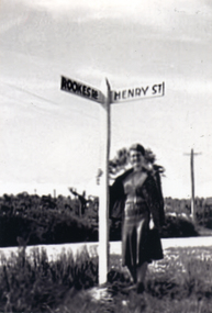
Photograph, Road signs - No roads
Sent to a parishioner at Christ Church Mitcham, by Phyllis Grant who lived at the Migrant Hostel in Mitcham in 1952-54, where her husband did development work under the P.M.G.Black and white photograph of road signs in Rooks Road. Note spelling of Rookes which is incorrect and Henry Street which no longer exists. It is presumed that it pointed to a street which lost its identity with the development of the Migrant Hostelrooks road mitcham -
 Whitehorse Historical Society Inc.
Postcard, Blackburn Road Blackburn
2 Black and white copies of Postcards of Blackburn Road looking South from Railway Road 1918. Reproduced from 'Blackburn A Picturesque History' by Robin Da Costa, Pioneer Design Studio P/L, Lilydale.blackburn road, blackburn -
 Surrey Hills Historical Society Collection
Photograph, Union Road, Surrey Hills in 1982 (3), 1982
Taken in January 1982; very similar to SHP0628 & SHP0635. Surrey Family Hotel (McNeill's Family Hotel) was built in 1888 by Alexander McNeill. It closed as a hotel after the Local Option vote in 1920. The Surrey Squash Courts were built in what had been the Surrey Theatre. The facade of the ANZ Bank building documents the past history of the building having earlier been the ES&A Bank. Black and white photo of Union Road at the intersection of Canterbury Road. On the right the edge of Dartnell's Pharmacy building on the SE corner can be seen and McNeill's Family Hotel building (pre-renovation) on the NE corner. Distinguishable advertising signs include the ANZ Bank and Dalkeith Office Supplies on the west side of Union Road beyond the intersection; also the Surrey Squash Courts.businesses, shops, union road shops, dartnell's pharmacy, mcneill's family hotel, surrey family hotel, anz bank, surrey gardens, dalkieth office supplies, surrey squash courts -
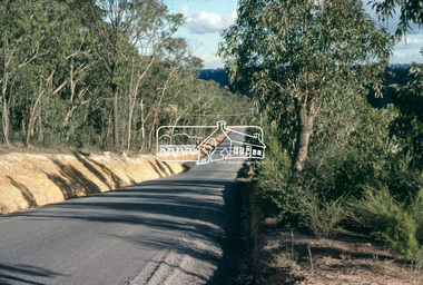
 Eltham District Historical Society Inc
Slide, Road sealing: Para Road, Briar Hill, Jun. 1981
Road sealing operations undertaken throughout the Shire of Eltham35 mm colour positive transparency (1 of 4) Mount - Kodak Kodachrome Cardinfrastructure, para road, road maintenance, road sealing, briar hill -
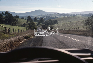
 Eltham District Historical Society Inc
Slide, Road sealing: Eucalyptus Road, Eltham, Jun. 1981
Road sealing operations undertaken throughout the Shire of Eltham35 mm colour positive transparency (1 of 4) Mount - Kodak Kodachrome Cardinfrastructure, road maintenance, road sealing, eltham, eucalyptus road -
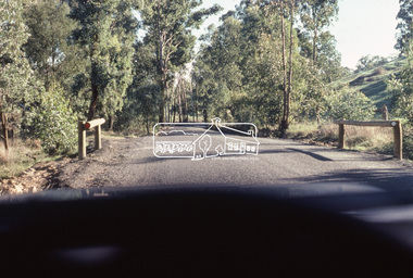
 Eltham District Historical Society Inc
Slide, Road sealing: Cottlesbridge-Strathewan Road, Jun. 1981
Road sealing operations undertaken throughout the Shire of Eltham35 mm colour positive transparency (1 of 4) Mount - Kodak Kodachrome Cardinfrastructure, road maintenance, road sealing, cottles bridge-strathewen road, mount sugarloaf -
 Eltham District Historical Society Inc
Slide, Road sealing: Cottlesbridge-Strathewan Road, Jun. 1981
Road sealing operations undertaken throughout the Shire of Eltham35 mm colour positive transparency (1 of 4) Mount - Kodak Kodachrome Cardinfrastructure, road maintenance, road sealing, cottles bridge-strathewen road -
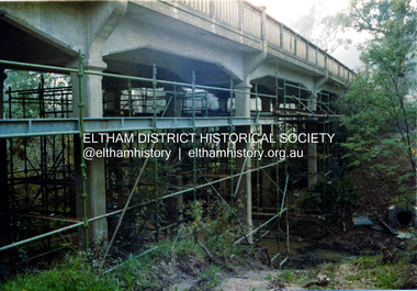 Eltham District Historical Society Inc
Photograph, Ruth H. Pendavingh, Reconstruction of Main Road from Main Road Bridge to Mount Pleasant Road, Eltham, 1984
The original timber bridge over the Diamond Creek was built around 1840. It was destroyed by floodwaters in October 1923. A temporary bridge was rigged up but further damaged in April 1924. A new concrete bridge was built and opened in October 1926. The bridge decking was widened along with Main Road to Dalton Street by the Road Construction Authority in 1984. The upgraded bridge was re-opened October 25, 1984, 78 years after its original opening. (EDHS Chronology of known local events 1835- early 2000)Three colour photograph prints 1984, bridge construction, diamond creek (creek), eltham south, main road, main road bridge, road construction -
 Marysville & District Historical Society
Photograph (Item) - Colour photograph, Unknown
A digital copy of a colour photograph taken along Falls Road in Marysville in Victoria.A digital copy of a colour photograph taken along Falls Road in Marysville in Victoria.falls road, marysville, victoria, photograph -
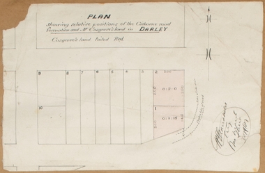 Bacchus Marsh & District Historical Society
Map, Plan showing relative positions of the Gisborne road formation and Mr. Cosgrove's land in Darley. 1907
No background information about the roadworks referred to in this plan has been found. The portion of land referred to as 'Cosgroves' in this plan is located close to the present day Darley Park Recreation Park in Darley, near Bacchus Marsh. The land indicated appears to be close to the corner of Grey Street and Gisborne Road. James Cosgrove who died in 1923 aged 65 owned a farm of 52 acres in this area of Darley.Single page map showing a proposed deviation of the Gisborne road in Darley and its position relative to land owned by Mr. Cosgrove. The land owned by Cosgrove is shaded in pink. No scale indicated. Part of a set of maps which are pasted into a bound volume containing 76 maps or plans in total. High resolution digital image stored on BMDHS computer network. Signature (illegible), Eng, Bac Marsh Shire, 30/9/07bacchus marsh roads and streets, darley victoria maps -
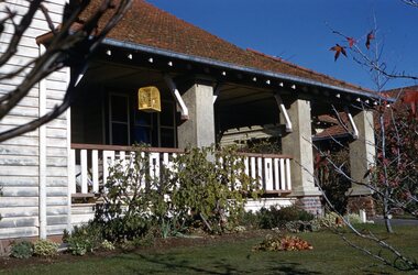 Surrey Hills Historical Society Collection
Photograph - Digital photograph, George L Coop, 688 Whitehorse Road, Mont Albert 1958, 1958
The donor George Lister Coop was about 21 years of age when he took this photo in 1958 of his family home. His parents were George Burton Coop (b c1906 Williamstown; died aged 54 years at Mont Albert) and Winsome Alice (MS: Trewartha) who married in 1936. They are first listed at this address in the electoral roll in 1937. They had 2 children: George Lister Coop - born St Georges Hospital, 8/10/1937 and Alison - born c1945. However the donor informed that he initially attended Chatham State School because his first home was the Spanish Mission style flats at 346 Whitehorse Road, opposite Brenbeal Street, Balwyn. When his grandparents died, the family moved to 688 Whitehorse Road and he then attended Mont Albert Central School. Alison being younger did not go to Chatham Primary. A digital copy of a colour photo showing detail of the front veranda of 688 Whitehorse Road. The house is white weatherboard in a modified Californian bungalow style with a tiled roof and the carport built within the roofline. The balustrades and finials of the veranda are simple with occasional feature planks with a tulip detail. A bird cage hangs from the veranda. The veranda is supported by rough-cast sturdy pillars.george l coop, whitehorse road, mont albert, uniting church, californian bungalow