Showing 1565 items matching " site plans"
-
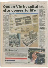 Queen Victoria Women's Centre
Newspaper excerpt, Queen Vic hospital site comes to life, 24 August 2003
newspaper articles Sunday Herald Sun page 28. colour photograph of the construction works bottom left of article's images. Graphic images of the the construction works and what would be included in the centre.town planning, historic building, retail trade, restaurants, construction and demolition workers -
 Surrey Hills Historical Society Collection
Document - Plans, Andrew Wood, Building plans associated with Andrew Wood, builder of Surrey Hills, 1920s
These plans were associated with Mr Andrew Wood, a contract builder who worked in the 1920s and built many Californian bungalows in Surrey Hills and surrounding suburbs. Andrew Wood was born in Chiltern in 1861 to Andrew and Ellen Wood (MS: Green). His father had emigrated from Falkirk, Scotland. As a young man Andrew worked as a carpenter in the mines in South Africa (c 1899). He married Eleanor Agnes Stuchbery in Hamilton, Victoria in May 1901. They had 5 children - Doris (M Roberts), Robert Andrew, Donald Allen, Jean (M Cowan), and Gwenyth (M Bray). The first 2 children were born in Hawthorn; the other 3 in Surrey Hills. The family home at 286 Canterbury Road, Surrey Hills (on the corner of Middlesex Road) was built by Andrew. Andrew died in 1940; Eleanor died in 1977, aged 100 years. After Eleanor's death the house was sold and demolished. Surrey Lighting was established on the site. Gwenyth May Wood (3 May 1917, Surrey Hills - 5 Jan 2004) married Leslie David Charles Bray (1921-1983). Gwenyth was the donor's mother. Andrew, Eleanor and one son Robert are buried in Box Hill Cemetery - B-071-0028. .1: Specifications & plans for the kinder hall, Howard Street, Mont Albert for the Mont Albert Methodist Church, May 1925 .2 Plans for a proposed villa, 48 Payne's Paddock, Highfield Road, Canterbury for Mr E H Sillifant, dated 22/4/1920 .3 Plans for a timber villa for Mrs J A Burchell at Riversdale Road, Surrey Hills, stamped 9/5/1922 .4 Plan of a garage at Victoria avenue, Canterbury; stamped 14/2/1922 .5 Building permit & receipt from City of Hawthorn re Lot 16 Homebush Crescent; dated 7/4/1925 .6 Plans for a concrete house at Camberwell for Mr H W Field andrew wood, builders, box hill cemetery, kindergartens, mont albert methodist church, building plans, highfield road, ernest horatio sillifant, victoria avenue canterbury, lot 16 homebush crescent, californian bungalows, h w field -
Stawell Historical Society Inc
Archive - CD/DVD, Gold Mining Relics of the Past - Surface and underground. Plan view of underground mine. Photographs of various mine sites. Underground workings of various mines, 2003
stawell, mines, relics, stokes, timbers -
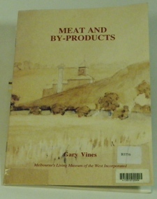 Melbourne's Living Museum of the West
Booklet, Melbourne's Living Museum of the West, Meat and By-Products, 1993
The meat industry and animal by-product works of Melbourne's West, in the series "Interpreting the Cultural Landscape", with the assistance of the Department of Planning and Development, VictoriaThe Australian Meat Preserving Company was established on the banks of the Maribyrnong River in 1870 on the site of boiling works dating from the 1840s.32 page booklet, A5, Cover illustration of Raleigh's boiling down works on the Maribyrnong River, from water-colour by Greeves C. 1850s Title: Meat and By-Products Author: Gary Vines Melbourne's Living Museum of the West Inc.western suburbs, meat industry -
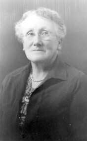 Surrey Hills Historical Society Collection
Photograph, Mrs Florence Margaret Tacey (nee Edwards)
Mrs Florence Margaret Tacey (nee Edwards) was the mother of Albert Arthur Tacey. She was born in 1863; died in 1943 in Camberwell. Her husband was William Tacey born in the Buckland Valley near Bright in 1857. There were many members of the Tacey family who were butchers. Various members of the family were associated with Tacey's Butchers at 629 Canterbury Road, Surrey Hills. According to a Context P/L heritage assessment of the property the land on which the business was built "was purchased by Edward Tacey on 16 September 1889. Edward Tacey was a butcher and the Sands & MacDougall street directory indicates that a butcher’s shop had been constructed on the site and was operating by 1890. It seems that the family lived for some time at a house located next door to the shop at 627 Canterbury Road (visible on the 1909 MMBW plan, but since demolished). On 15 June 1920 Edward Tacey transferred all three blocks of land to Joseph Tacey, most likely his son * and also a butcher, who carried on business from the same premises. Joseph Tacey died on 20 February 1933, after which administration of his estate (which included the three blocks of land) passed to his widow, Mary Dorothy Tacey." Edward Tacey (1863 - 1952) was the brother of William Tacey (1857 - 1920). The property passed to Joseph Charles Tacey (1887 - 1933), his nephew and son of William, not his son. His wife was Mary Dorothy Coates. Albert Arthur Tacey was a brother of Joseph Charles Tacey. The SHNCHC has a large framed photo collage of the Tacey butcher's shop at 629 Canterbury Road. It hung in various Tacey family-owned butcher's shops around Victoria before coming back to Surrey Hills. The donor was the daughter of Albert Arthur Tacey (1902-1959). A black and white photograph of an older lady. She has greying hair, is wearing rimless glasses, pearls and a jacket over her dress.surrey hills, butchers, mrs florence margaret tacey, miss florence margaret edwards, william tacey, joseph charles tacey, albert arthur tacey -
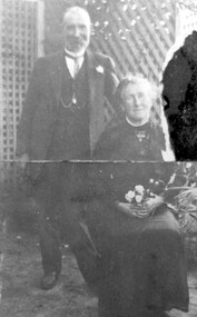 Surrey Hills Historical Society Collection
Photograph, Mr and Mrs William Tacey
William (1857 - 1920) was a butcher. William was born 7 Nov 1857 on the Buckland (River) near Bright, son of John Joseph Tacey and wife Elizabeth Cooper. This was just a few months after the Buckland River anti-Chinese riots. He had siblings Thomas (1856-1929), Mary Ann (1860-1920), Edward (1863-1952) and Arthur Edward (1870-1896). William died 30 March 1920, Camberwell. He married Florence Margaret Edwards in 1884. Both are buried in Box Hill Cemetery (CE-0162). They had 7 surviving children; 2 died in infancy. William was a butcher in Thornbury but moved to Camberwell with his brothers seeing the opportunity in the new suburbs. They set up shops in Canterbury Road, opposite Highfield Road, Surrey Hills; Burwood; corner of Elgar & Whitehorse Roads, opposite the Whitehorse Hotel and Canterbury Road, Surrey Hills just east of Surrey Hotel. The first directory entries are in 1888 & 1889 for the Surrey Hills shop & Elgar Road. In Surrey Hills a substantial property was developed on land which "was purchased by Edward Tacey on 16 September 1889. Edward Tacey was a butcher and the Sands & MacDougall street directory indicates that a butcher’s shop had been constructed on the site and was operating by 1890. It seems that the family lived for some time at a house located next door to the shop at 627 Canterbury Road (visible on the 1909 MMBW plan, but since demolished). On 15 June 1920 Edward Tacey transferred all three blocks of land to Joseph Tacey, most likely his son * and also a butcher, who carried on business from the same premises. Joseph Tacey died on 20 February 1933, after which administration of his estate (which included the three blocks of land) passed to his widow, Mary Dorothy Tacey." (Context P/L Heritage Assessment) Correction: *Edward Tacey (1863 - 1952) was the brother of William Tacey (1857 - 1920). The property passed to Joseph Charles Tacey (1887 - 1933), his nephew and son of William, not his son. His wife was Mary Dorothy Coates. Albert Arthur Tacey was a brother of Joseph Charles Tacey. Edward later moved from the area and continued in the business in a number of regional Victorian centres. In Surrey Hills the business was continued by other members of the family including Albert Arthur Tacey (1902-1959) who lived at 7 Sunbury Crescent, and daughter Stella Florence Tacey and her husband Roy Morris and their son Harry Tacey Morris. The donor of the Tacey collection of photos was Elaine Merle Tacey (1925-2003), daughter of Albert Arthur Tacey. She married Donald McKenzie. A black and white photograph of a couple in the garden. The man is standing and wearing a 3 piece suit whilst the lady is seated and holding a posy of flowers in her lap.(mr) william tacey, butchers, (mr) edward tacey, (mr) thomas tacey, (mr) joseph tacey, (mrs) stella morris, (mr) roy morris, (miss) florence margaret edwards, (mrs) florence margaret tacey, (mr) albert arthur tacey, (miss) stella tacey, (mr) harry tacey morris -
 Surrey Hills Historical Society Collection
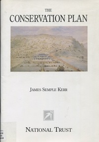
Book, The Conservation Plan: a guide to the preparation of conservation plans for places of European Cultural Significance, 1996
... . The result of these processes is a conservation plan. historic sites ...This guide is about gathering, analysing and assessing information that bears upon policy decisions and on the process of making those decisions. It offers a common ground for debate, a method and a common language to help resolve differences and achieve a balance between the old and the new. The result of these processes is a conservation plan.historic sites - australia - conservation and restoration, historic buildings - conservation and restoration - ausation of places of cultural significancetralia, monuments - australia - conservation and restoration, australia/icomos charter for the conserv -
Surrey Hills Historical Society Collection
Planning report, City of Boroondara, City of Boroondara planning report re 171 Union Road, Surrey Hills, 19/07/2004
171 Union Road was part of the Thomas Zeplin estate. It originally had a Victorian house on it built by the Zeplin family. This was leased by Dr Percy Liddle and then Dr James Landells Blakie. Dr Blakie purchased land diagonally opposite at 174 Union Road and had a purpose-built home / surgery constructed. Later the site was occupied by COR then a BP petrol station.A detailed proposal regarding the redevelopment of the petrol station site on the corner of Union Road and Montrose Street, Surrey Hills into a 2 storey office and shop building with basement parking and access from Montrose Street. It includes attachments showing plans, elevations and details regarding objectors. The application was granted subject to additional conditions being met. union road, redevelopment, shops, town planning -
 Vision Australia
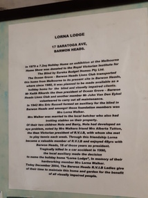
Photograph - Object, Lorna Lodge, 2004
This board was constructed to provide information about the history of Lorna Lodge and to display some photographs and a newspaper cutting relating to this. The photographs are (clockwise): Photograph of Lorna Lodge on December 26, 1969 with a man standing outside and three children on the ramp leading to the front door. Photograph of Miss Elizabeth Skene, oldest member, at the 60th anniversary of the Barwon Heads auxiliary. Newspaper cutting: Ocean Grove News. Luncheon to help the blind. Ocean Grove has its fair share of fundraising groups. And the Royal Victorian Institute for the Blind, Ocean Grove Auxiliary is up there with the most hardworking. Pictured at the auxiliary's recent meeting are president Lorna Walker, secretary Vera Montgomery and treasurer Grace Brown. Talking of fundraising, the auxiliary will hold a casserole luncheon at the Ocean Grove Bowling Club on Monday, June 6 at noon. Tickets are available at the door at $5. Photograph of 60th anniversary in 2002 of RVIB Barwon Heads Mrs Grace Brown President and Yvonne Conners of Geelong West with a cake marking the occasion. Photograph of Bonnie Cameron and Vera Montgomery, RVIB Members holding a picture of the boat shed at Barwon Heads. Photograph of RVIB Life Members Achievement Award, awarded in recognition of support from Barwon Heads Auxiliary. Presented by Governor of Victoria John Landy at Government House on March 26th, 2003. L-R: Lorraine Gleeson, Jill Smith, Bonnie Cameron, Alice Donally, Wyn O'Brian, Una Harding and Dawn White. Photograph of Mrs Lorna Walker. In 1979 a 7.2 sq holiday home on exhibition at the Melbourne Home Show was donated to the Royal Victorian Institute for the Blind by Eureka Budget Homes Pty Ltd. The Ocean Grove - Barwon Heads Lions Club transported this home from Melbourne to it's present site in Barwon Heads, where since 1980, it was planned to be made available as a holiday home for the blind and visually impaired clients. Mr Keith Rikards the then president of Ocean Grove - Barwon Heads Lions Club and another member Mr John Van Den Eykel volunteered to carry out all maintenance. In 1942 Mrs Eric Russell formed an auxiliary for the blind in Barwon Heads and amongst these foundation members was Mrs Lorna Walker. Mrs Walker was married to the local butcher who also had trotting stables on their property. Of their two children, Nola and Barry, Nola had developed an eye problem, noted by Mrs Walker's friend Mrs Alberta Tutton, the then Victorian President of RVIB, with whom she met to play tennis with each week. Through this friendship Lorna became a valuable member of the RVIB and enjoyed 48 years with Barwon Heads, 18 of those years as President. Tragically killed in a car accident in 1990, the local auxiliary made the decision to name the holiday home 'Lorna Lodge', in memory of their hardworking member Mrs Lorna Walker. Today December 2004, The Barwon Heads RVIB Ladies give of their time to maintain this home and garden for the benefit of all visually impaired people.Image of board with photographs, text and newspaper cuttinglorna lodge, royal victorian institute for the blind -
 Vision Australia
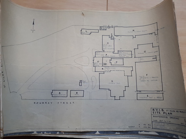
Plan - Image, RVIB Maintenance drawing, April 1963 - November 1966
... plans 9 pages of plans of buildings on St Kilda road site RVIB ...A series of maintenance drawings were made or copied by an architectural firm. These plans include: 1 - St Kilda Road Property - a site map of the buildings and grounds with the names of the various areas added. 2 - St Kilda Road Central Building (copied from a RAAF drawing) showing rooms on the ground floor. 3 - St Kilda Road Central Building (copied from a RAAF drawing) showing rooms on the first floor. 4 - St Kilda Road Central Building roof plan. 5 - St Kilda Road Factories showing the layout on the ground floor. 6 - St Kilda Road Factories showing the layout on the first floor. 7 - St Kilda Road building showing all three floors of the building rented out to Alfred Hospital. 8 - St Kilda Road caretaker, factory, fundraising and rehabilitation training buildings. 9 - Raleigh Street, Prahran hostel layout for both girls and boys.9 pages of plans of buildings on St Kilda road siteVarious - see individual plansmyer house, royal victorian institute for the blind, plans, raleigh street hostel, alfred hospital -
 Vision Australia
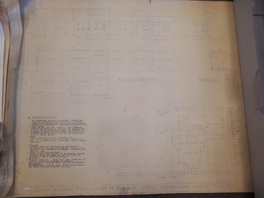
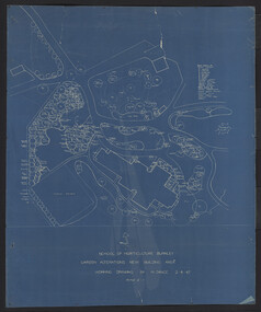
Plan - Image, Proposed additional nurses bedroom to "Myer Home" existing nursery, Blind Institute, St Kilda Rd, 23/8/1949
In 1949 an architect produced this plan to detail the addition of a bedroom for the nursing staff, who looked after children in the Blind Babies nursery. The plan shows a layout of the RVIB site, including the 'Myers Home' (the name of the nursery) where young children were cared for. The south and eastern elevations are detailed, as well as a plan of the nursery, which had 4 bedrooms, a living room, a dinning room , bathroom, 2 kitchen areas and the proposed additional nurses bedroom next to Bedroom 4.1 architectural plan of Myer House and proposed extensionPercy E Everett, Chief Architectroyal victorian institute for the blind, rvib nursery, plans, myer house -
University of Melbourne, Burnley Campus Archives
Plan - Sketch, Plan of Burnley Gardens, 1970-1980
... on the site. Plan of Burnley Gardens Plan Sketch ...Plans A and B. 2 identical hand drawn sketch plans of area bounded by manure bins, pumphouse to the east, milking shed and silo to the west: showing all buildings on the site.burnley gardens, buildings, burnley school of horticulture -
 University of Melbourne, Burnley Campus Archives
Plan, Hilda Marriott ( Dance), Garden Plans by Hilda Marriott (Dance), 1947-1981
... was also involved in the planning of this site.) (2) Tracing paper... was also involved in the planning of this site.) (2) Tracing paper ...Set of 8 plans, including blue-prints, of various gardens, dated c. 1947 - 1981. See paper catalogue for complete list.Plans by Hilda Marriott Dance (1) Sketch plan and 2 blueprint copies of School of Horticulture Burnley. Garden Alterations New Building Area, Working Drawing by H. Dance, Scale ⅟₂₀"=1', 2/4/47, on reverse handwritten,"Proposed Garden Lay-out for New School Building (H. Dance-plan)." (NB Emily Gibson was also involved in the planning of this site.) (2) Tracing paper, paper and blueprint copies of Ararat & District Hospital Garden Plan - MacDonald Memorial & Court, Landscape Architect - H. Dance, Scale 1 inch=8 feet. Includes handwritten note, "Replacement for Ararat Hospital Nov. 1979," list of plants. (3) Blueprint Proposed Design for Garden Watermill Farm, Newbury for Norman Gadsden Esq., Scale ⅟₄₀"=1 ft. (4) Sketch Plan for Garden, Barcombe, Buangor - January 1981 by Hilda Marriott, Scale - Approximate Only - 1:40. (5) Tracing paper copy of plan of Garden at Plumhill, Templestowe, for Mr. & Mrs. Colin Smith. Hilda Dance, Designer 26/4/47, Scale ⅛"=1'. (6) Blueprint Garden House - Sketch. (7) Tracing paper and paper copies Ararat Medical Centre Courtyard Garden, Landscape Architect - Hilda Marriott, Scale - 1:25, Date 8.5.79. (8) Tracing paper copy National Trust of Australia (Victoria) The Heights, Newtown, Geelong Garden Plan, Scale 1:250, Drawn by - Hilda Marriott, Date 12.10.79.(1): on reverse handwritten,"Proposed Garden Lay-out for New School Building (H. Dance - plan)." (2): Includes handwritten note, "Replacement for Ararat Hospital Nov. 1979," list of plants.hilda marriott ( dance), burnley school of horticulture, students -
 University of Melbourne, Burnley Campus Archives
Plan, M. Drake et al, Site Location Plan of Incubator Building and Random Sample Laying Test for Burnley Gardens, 1967
... Site Location Plan of Incubator Building and Random Sample..., Chief Architect. Site Location Plan of Incubator Building ...Plan by Public Works Dept., Melbourne. M. Drake (draughtsman), R. G. Wilson, Chief Architect.m. drake, g.r. wilson -
University of Melbourne, Burnley Campus Archives
Plan, Proposed Site for Plant Science Laboratory and Glasshouse Block, 1964
Plan on tracing paper.laboratory, glasshouse -
 University of Melbourne, Burnley Campus Archives
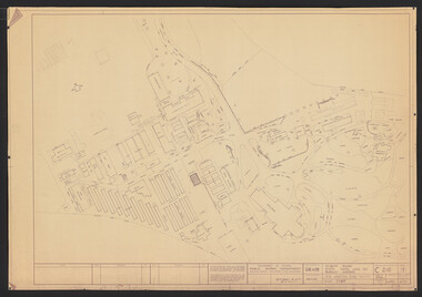
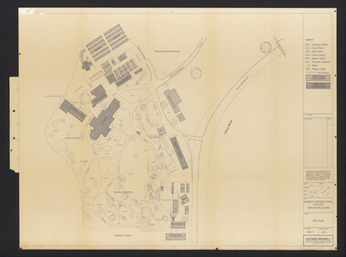
Plan, Burnley Horticultural College: Site Plan, 1983-1984
... Burnley Horticultural College: Site Plan.... B11.0599 SP/3. Burnley Horticultural College: Site Plan Plan ...Plans of the Burnley Campus, Ornamental Gardens from Plan 11.0715 by Alexander Metherell Pty. Ltd. Dated November 1983. Scale 1:500. (1) 5 copies, buildings shaded showing construction type. Job No BHC/1 Drawing No SP/1. Tree placements stamped on, includes legend. (2) 2 copies No SP/1c. In Description column, "A" Building Names 7/02/1984. Also see B15.0352 full report. B11.0715 originals. B11.0599 SP/3.ornamental gardens, burnley campus, burnley horticultural college, alexander metherell p/l -
 University of Melbourne, Burnley Campus Archives
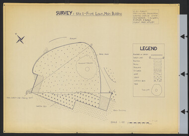
Plan, Survey: Site 1 - Front Lawn, Main Building, 1985
Plan of Front Lawn area with legend. V.C.A.H - Burnley Horticultural Engineering Surveying Exercise dated 10.09.1985. Group Members: T. Allworth, M. Appleby, B Barker (Student: Mary Appleby). Scale 1:100.vcah, lawns -
University of Melbourne, Burnley Campus Archives
Plan, Roh Cross, Lilydale Quarry Recreational Study for Landscape Studies, 1986
Plans on tracing paper and paper by Rob Cross Landscape Design. (1) Site Analysis No 1 dated 08.06.96. Scale 1:2400. (2.) Proposed Activity Zones No 2 dated 03.06.96. Scale 1:2400. (3) West Section of Valley No 3 dated 11.06.96. Scale 1:1000. (4) Concept Plan No 4 dated 11.06.96. Scale 1:2400. (5) Axonometric View No 5 dated 30.06.96. Scale 1:2400.lilydale, quarry, rob cross landscape design, landscape studies -
University of Melbourne, Burnley Campus Archives
Plan, C. van Zwel, A Blind Lady's Dream - Site Analysis, 1983
... colour photographs. A Blind Lady's Dream - Site Analysis Plan C ...Proposed garden for Mrs C van Zwol of 99 St Clem's Road East Doncaster 3109. Microclimates, Influences and Services by Jacinta Bartlet.t Drawing No 3/8 dated October 1983. Includes 7 colour photographs.jacinta bartlett, east doncaster, microclimates -
University of Melbourne, Burnley Campus Archives
Plan, Kirsten Strutt, Central Gardens Hawthorn, 1996
Plans by Kirsten Strutt (student) for Hawthorn City Council. Scale 1:500. (1) Site Analysis September 1986. (2) Tree Survey October 1986 Drawing No 2.kirsten strutt, hawthorn, gardens, central gardens hawthorn -
University of Melbourne, Burnley Campus Archives
Plan, Jacqueline Fraser, The Chivers House 34 Finlayson Street Malvern East, 1991
(1) Jacqueline Fraser - Site Inventory and Analysis dated 5.11.91, Conceptual Design dated 1.11.91, Planting Plan and Section Elevation dated 8.11.91. Scale 1:100. (2) Troy Watchorn - Site Analysis and Inventory, Concept Plan, Planting Plan, Section Elevation, dated 14.11.1991. Scale 1:100. (15 sheets)jacqueline fraser, troy watchorn, landscape design, malvern -
University of Melbourne, Burnley Campus Archives
Plan, Base Plan Residential Landscape, 1994
2 plans on tracing paper dated 17.03.1994 and 23.03.1994. Same site, different anotation. Scale 1:100. Drawn by J.K.landscape design, residential -
University of Melbourne, Burnley Campus Archives
Plan, Alexander Metherell Pty. Ltd, Report on Existing Site Conditions at Victorian College of Agriculture and Horticulture Burnley, 1983
... and B11.0599 for descriptions of plans. Report on Existing Site ...Report in plastic folder by Alexander Metherell Pty. Ltd., Melbourne dated November, 1983. Includes plans of Orchard and Campus. See B11.0716 and B11.0599 for descriptions of plans.alexander metherell, vcah, burnley -
 Vision Australia
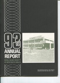
Administrative record - Text, 93rd Annual Report Royal Blind Society of N.S.W. (1973), 1973
Articles in the annual report include: the expenses incurred due to increased client numbers and wages rises, the need and inability to sell the Woollahra (Helen Keller hostel) site, the success of the fledging Reference Library seen as a model for other organisations, Matron Scott (Victor Maxwell nursery) received an M.B.E., plans to develop 3 more day centres to add to the five already operating, operations undertaken in the workshop, continued demand for places at Alexis Albert and Lighthouse hostels, recognition through the renaming of 2UW Blind Appeal to the 2UW Lions Blind Appeal which has been run since 1952, blind bowlers looking forward to being on the green at Enfield, Cricket club looking forward to when tip in Mitchell St is filled in so that it can be made into a home ground, and the collaborative relationship had with other blindness related organisations.1 volume of text and imagesroyal blind society of new south wales, corporation records -
 Vision Australia
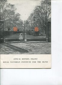
Administrative record - Text, Royal Victorian Institute for the Blind annual report 1957-1958, 1958
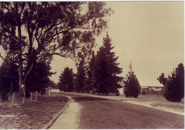
... approved revised sketch plans for 42 acre site at Box Hill... approved revised sketch plans for 42 acre site at Box Hill ...Events that occurred during the year : further expansion of nursery with 3 children under the age of 3 admitted, first Aboriginal child (Alexander Marks) was admitted, children gained 23 swimming certificates, some Scouts met Lady Baden Powell, Board approved revised sketch plans for 42 acre site at Box Hill, doubling of Talking Book Library service with additional 60 machines purchased at a subsidised cost courtesy of the Nuffield Foundation, Alberta Tutton is taking a break from Auxiliary President duties with J. A. Duncan filling the temporary vacancy, thanks to Mabel Nelson for acting as accompaniste to concert artists, resignation of Alban Whitehead as a Country Concert Party manager and appointment of Denis Bandel in the position, outgoing Council member Cr. W.J. Wrens was recognised as Companion of the Order of the British Empire, and Captain Semmens and crew of 'Triaster' provided play equipment for playground. Dick Sutcliffe led the blind orchestra as it played 'There'll Always Be An England" as Queen Mother drove by the Institute and stopped when she saw the crowd of blind children and workers waiting for her, accepting a bouquet of gardenias from Margaret Oliphant.1 volume of text and illustrationsannual reports, royal victorian institute for the blind -
 Vision Australia
Administrative record - Text, Royal Victorian Institute for the Blind annual report 1956-1957, 1957
... courses, and plans for Box Hill site have had to be re-drawn given..., and plans for Box Hill site have had to be re-drawn given decreased ...Events that occurred during the year : two day 'Olympic Fair' held at Ormond Hall, opening of a Community Mart at 382 Chapel St in conjunction with School for the Deaf, Alfred and Prince Henry hospitals, Penny Serenade program conducted by John Best on 3KZ and Janet Irving a Penny Serenade Ball has increased funds, six concerts held at Melbourne Town Hall, resignation of Country Concert Party director John Broadway and succeeded by Alban Whitehead, two stalls operated at Royal Agricultural Show, Easter Scout Camp at Gilwell Park, visit to Olympic Village, matinee performance by Dame Margot Fonteyn, opening of St Paul's School for Blind has decreased enrolments and two ex-pupils (Joan Ryan and Hugh Jeffrey) are on staff there, Keith Smith, Joan Ryan and Margaret Russell completed their university courses, and plans for Box Hill site have had to be re-drawn given decreased numbers due to opening of St Paul's - resulting in a delay to the start of building.1 volume of text and illustrationsannual reports, royal victorian institute for the blind -
 University of Melbourne, Burnley Campus Archives
Photograph - Sepia print, A.E. Bennett, Entrance Gates, 1894-1990
Note by E.B. Littlejohn, "Is the roadway the original Swan Street? Entrance gates to Gardens in the distance. Roadway leading to the Pavilion hidden behind the trees. No elms showing along the roadway," and by T.H. Kneen, "The roadway appears to terminate at the gates outside the Curator's Residence, sweeping past the Pavilion on the right. I have seen a plan which showed an attractive avenue of trees (pine) from the western end of the property (where the Stockman's Cottage was later sited.)" 2 copies sepia photograph. Copy of sepia photograph of the roadway to the Entrance Gates and Curator's Cottage seen in the distance, with the Pavilion on the right, in, "Prize Essays," Alfred E. Bennett, c.1894, after p 116. Pinus radiata avenue on each side of the road.entrance gates, prize essays, alfred e. bennett, curator's residence, pavilion, stockman's cottage, pine tree avenue -
University of Melbourne, Burnley Campus Archives
Work on paper (item) - Student Work, Luke Flanagan, Marriott Residence Landscape Design, 2016
Submitted as an assignment for HORT90035, 'Landscape Construction and Graphics,' coordinated by Andrew Laidlaw. assignment, landscape construction and graphics, landscaping, hort90035, burnley horticultural college -
University of Melbourne, Burnley Campus Archives
Work on paper (item) - Student Work, Perry Lane, Glenlyon RD Landscape Design, Uncertain, probably 2017-2018
Submitted as an assignment for HORT90035, 'Landscape Construction and Graphics,' a subject at Burnley Horticultural College coordinated by Andrew Laidlaw. It seems a third sheet of paper is missing, though one of the folders does contain a rubric showing the mark received for this project. assignment, landscaping, burnley horticultural college, landscape construction and graphics, hort90035 -
University of Melbourne, Burnley Campus Archives
Work on paper (item) - Student Work, Jane McKenzie-Smith, Ironbark Designs Landscape Design, 2015
The sheets were submitted as part of a landscape design project, most likely for HORT90035, 'Landscape Construction and Graphics,' a subject at Burnley Horticultural College coordinated by Andrew Laidlaw. It seems there is a third sheet missing that would have been the site analysis component of this project. assignment, landscaping, burnley horticultural college, landscape construction and graphics