Showing 10610 items
matching sites
-
 Ringwood and District Historical Society
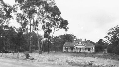
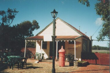
Photograph, House on Site of Ringwood Library, Warrandyte Rd, 1964 (Barrett / Polkinghorn)
3 copies of photographWritten on backing sheet of one copy, "Site of Ringwood Library, Warrandyte Rd, 1964. (Polkinghorn's House)." This contradicts the inscription on second copy which is "Barrett's home, Warrandyte, Rd. Ringwood. The site became Ringwood Library, and in 1998, the Maroondah Community Service Centre."(It is believed both families lived in this house) -
 Federation University Historical Collection
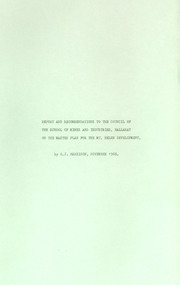
Booklet - Report, Report and Recommendations to the Council of the School of Mines and Industries, Ballarat on the Master Plan for the Mt Helen Development, 11/1968
A master plan for the campus was developed by L.H. Vernon and Associates. Geoff J. Harrison prepared a report and made recommendations on the master plan, including suggestions for improvement. Grey card covered, stapled, foolscap report on the Mount Helen Development. It included 14 typed pages and 6 plans. The report covers: Campus planning, Mt Helen Master Plan, retention of trees, sports fields, student accommodation, student amenities, library, car parking, site, landscape, land use study, Mt Helen Site, L.H. Vernon.mount helen master plan, masterplan, master plan, vernon, g.j. harrison, harrison, education, topography, survey, jd fisher, aa jeffreys, hugh mitchell, john vernon, geoff harrison, mount helen master plan, l.h. vernon, campus plan, mount helen campus -
 Bendigo Historical Society Inc.
Document - LONG GULLY HISTORY GROUP COLLECTION: LETTERS FROM THE LONG GULLY HISTORY GROUP
Letter dated 7th May 2002 to Councillor Willi Carney from George Ellis, Long Gully History Group requesting the council to consider the site in their original application for the marker to acknowledge the achievement of underground mining Linear Park Long Gully. The allocated site is unsuitable as the ground is unstable and work to stabilise the ground to stop it from tipping could double the cost.bendigo, history, long gully history group, the long gully history group - letters from the long gully history group, councillor willi carney, city of greater bendigo, george ellis -
 Kew Historical Society Inc
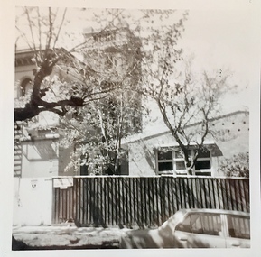
Photograph - 'Villa Alba', 44 Walmer Street, 1981
Villa Alba, a two-storeyed residence with rendered masonry walls and a slate roof, stands opposite Studley Park, overlooking the Yarra River. It is believed to have been first built before 1863, but substantially remodelled and enlarged in about 1882-83 for William Greenlaw, the Manager of the Colonial Bank of Australasia. Although the house and its tower must always have been a landmark in the area and the architecture is unusual, almost Norman in style, it is the interior which is the most remarkable feature of Villa Alba. (Source: VHD)Small black and white photographic positive of Vila Alba, 44 Walmer Street, Kew in 1981 when the original 1880s house was surrounded by hospital wards. The latter had been built by the Royal Women's Hospital after it acquired the site in 1950. The site wa Slater transferred to the Mount Royal Hospital before being purchased and converted into a museum of interior design.Verso: "Villa Alba 1981"villa alba -- 44 walmer street -- kew (vic.), mount royal hospital, henry pride wing -
University of Melbourne, Burnley Campus Archives
Plan, Irwin, Johnston & Partners Pty. Ltd, State College of Victoria, Toorak, 1977
Plans by Irwin, Johnston & Partners Pty. Ltd. dated July 1977. (1) Preliminary Site Services Plan: Fire, Cold Water and Gas Services. Job No 8482 Sheet No H4 of 4. Scale 1:200. Drawn by E.A.H. (2) Site Services Plan - Electrical, Fire, Cold Water and Gas Services. Scale 1:200. Drawn by E.A.H.state college of victoria -
 Falls Creek Historical Society
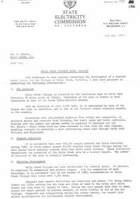
Document - SEC Information related to Tourist Hotel Project, 04.05.1967
Bob (Herman) Hymans (a former member of the Royal Netherlands Navy) was born in Bloemendaal, Holland on 30th September 1922. During World War II he fought against the Japanese in the Dutch East Indies (now Indonesia) and was imprisoned in Changi and on the Burma Railway. After gaining qualifications as a Ski Instructor, Bob arrived in Falls Creek in July 1950. Working as an Instructor and Supervisor at Bogong Lodge, Bob decided his future was in accommodation. He was successful in negotiating an indenture for land from the State Electricity Commission (SEC). It took Bob two years to build his Grand Coeur Chalet but, tragically, it was burned down in August 1961. Bob also built the first Chairlift in Australia. This was a single chairlift and the structure was built from wooden electricity poles. He was constantly full of new ideas and proposals for the village. Bob Hymans die on 7th July 2007. This Collection of documents and letters tells the story of Bob's endeavours to develop Falls Creek into the ski village it is today.This item is significant because it documents proposals put forward by Bob Hymans to develop facilities in the Falls Creek Tourist Area.A letter from the SEC to Mr Hymans outlining information related to the Falls Creek Tourist Hotel Project. Topics covered include: Tourist Potential; Existing Development in the area; information regarding the Site For Development; Liquor Licence; Lease; Process for submission of applications & Designs; References Required; Inspection Recommended prior to application. A general Plan & Aerial Photo of the proposed site was enclosed.falls creek tourist area management committee, falls creek administration, sewerage system falls creek -
Clunes Museum
Photograph - PHOTOGRAPH CLUNES 1860, CIRCA 1860
COLLAGE - CLUNES IN THE 1860's SIX REPRODUCED PHOTOGRAPHS MOUNTED IN WOODEN FRAME WITH BOLD EMBOSSED TRIM. CRITERION QUARTZ MINING COMPANY, PORT PHILIP & COLONIAL GOLD MINING COMPANY, VICTORIA QUARTZ MINING COMPANY. VIEW OF CAMP HILL , VIEW OF PORT PHILIP MINE SIGHT, VIEW OF THE LEVEL SITE OF BATTERY SEEN ON THE SITE ALONG STATION FLAT ROAD.local history, photographs, mining and township -
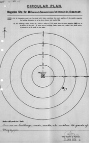 Ringwood and District Historical Society
Plan of magazine site, Mines Dept, Explosives Magazine Licence and Maps, Wonga Rd Ringwood. 1940, 1936, 1938-1940
Plans for the magazine site in Ringwood, located at Wonga Road, Ringwood. Magazine licence 2 pages. Area map showing Warrandyte, Ringwood and Deep Creek. -
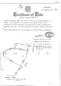 Eltham District Historical Society Inc
Document, Photocopy of Certificate of Title, Eltham War Memorial Trust, Lot 2, Plan of Subdivision No. 63242, Parish of Nillumbik; derived from Vol. 7073 Fol. 498, 18 May 1964, 1964
A4 photocopy Also Shire of Eltham plan of site with proposed security fence highlighted, c.1970 And Plan of Eltham Activity Centre, c.2010certificate of title, eltham war memorial, eltham war memorial trust -
 Phillip Island and District Historical Society Inc.
Photograph, 1944
One of a collection of over 400 photographs in an album commenced in 1960 and presented to the Phillip Island & Westernport Historical Society by the Shire of Phillip IslandPhotograph of Harmon West with his son and grandson at a Tree Planting on Cowes Esplanade in 1944. Mr West had attended a planting on same site in 1884.local history, photography, harmon west, the esplanade, cowes, black & white photograph, cowes esplanade, tree planting, john jenner, bryant west -
Glenelg Shire Council Cultural Collection
Photograph, View of Portland Harbour and port, 1960s
Port of Portland Authority archives.Front: (no inscriptions) Back: (no inscriptions)port of portland, lady bay -
Glenelg Shire Council Cultural Collection
Photograph - Sheet of 6 contact prints, 1964
Port of Portland Authority ArchivesFront: 87. 23-9-64 88. 23-9-64 89. 23-9-64 90. 23-9-64 91. 23-9-64 92. 23-9-64 (In white beneath each print.)port of portland archives, silo construction -
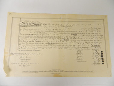 Kiewa Valley Historical Society
Deed, Batman's Melbourne Deed c1835, Original 6 June 1835. Copied 1966
Facsimile of the oriental in the Latrobe Library of the acquisition of 600,000 acres of land (sites of Melbourne & Geelong) between John Batman & Principal chiefs of Dutteallar native tribe.john batman. -
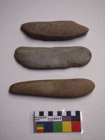 Bunjil Park Aboriginal Education & Cultural Centre
Sharpening stones
A set of 3 sharpening stones found on site at Bunjil Park. They are fine sandstone and range from 18cm to 19.5cm long and 4 to 6 cm wide. -
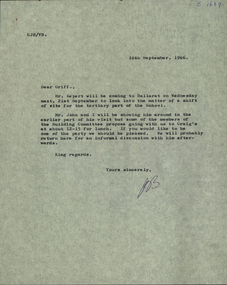 Federation University Historical Collection
Correspondence, E.J. Barker, Letter concerning the search for a new site for the Tertiary division of the Ballarat School of Mines, 1966, 16/09/1966
The tertiary division of the Ballarat School of Mines was built at Mt Helen. The sod was turned in 1967, and the first student attended the Mt Helen Campus in 1970.Typed copy of a letter from E.J. Barker, Principal of the Ballarat School of Mines, concerning the site of a new campus for the tertiary division of the Ballarat School of Mines. ballarat school of mines, tertiary division, mount helen campus, ballarat institute of advanced education, jack barker, e.j. barker, kepert, morgan b. john, craig's hotel -
Glenelg Shire Council Cultural Collection
Photograph - Photograph - Main Breakwater construction, Portland, Jan-60
Port of Portland Authority ArchivesFront: MAIN BREAKWATER PARAPET - View North at round head showing roundhead base completed and first two "bridge pier" Key blocks cast for straight parapet Jan '60 typed Back: Main Breakwater Parapet View N at roundhead, showing roundhead box completed and first two "bridge pier" key boxes cast for straight parapet. Written in blue biroport of portland archives, main breakwater, construction, portland, harbour, harbour development -
Glenelg Shire Council Cultural Collection
Photograph - Photograph - Main Breakwater construction, Portland, n.d
Port of Portland Authortity Achivesport of portland archives, main breakwater, construction, portland harbour, harbour development -
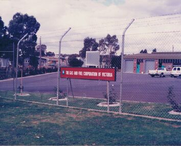 Bendigo Historical Society Inc.
Photograph - CASTLEMAINE GAS COMPANY COLLECTION: PHOTO GAS AND FUEL SITE
Photo of ''The gas and fuel corporation of Victoria'' site. Taken from outside barbed wire fence around perimeter, a building and 2 cars can be seen.business, retail, gas and fuel -
 Bendigo Historical Society Inc.
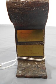
Ephemera - Cross section of tram track Bendigo 1890
BHS Collectionhistoric Bendigo tram track profile 1890 from original Tram depot in Mollison StreetOriginal No. 29 Battery Tram Track, Bendigo Tramways 1890. Dug up from Mollison Street, Bendigo, where the Tram Depot used to be sited. Brass tags note Bendigo Tramways 1890 and Original No. 29 Battery Tram Tracktramways bendigo, tram track profile 1890 -
 Bendigo Historical Society Inc.
Photograph - EDITH LUNN COLLECTION: MOLIAGUL GENERAL STORE
Moliagul General Store, relocated to Bendigo Pottery 13A exterior of the old store, sited at beendigo pottery 13B notice on the history of the old store and MoligulEdith Lunn -
 Bendigo Historical Society Inc.
Slide - RALPH BIRRELL COLLECTION: EIG SCHOOL, c1966
EIG School - Ralph Birrell Collection. Men and women gathered at site. C1966. Makings Kodachrome Transparency, in red print6 66M8, in yellow Made In Australia.Kodakeducation, tertiary, latrobe university bendigo, eig school - ralph birrell collection gatering people c1966 -
 Bendigo Historical Society Inc.
Slide - RALPH BIRRELL COLLECTION: EIG SCHOOL, c1966
EIG School - Ralph Birrell Collection. - Construction of Latrobe Uni. C1966. Bendigo Institute of Technology, Engineering School, Applied Science. Wattle growing on site.Kodakeducation, tertiary, latrobe university bendigo, eig school - ralph birrell collection. - construction of latrobe uni. c1966. bendigo institute of technology, engineering school, applied science. wattle -
Port Melbourne Historical & Preservation Society
Plan - Bayside development, Port Melbourne, Sandridge City Development Company Pty Ltd, 14 Jun 1989
Site plan DP-1.00. Proposal plan for Bayside development incorporating Princes and Station Piers, Missions to Seamen Building (on a canal) and 2 new hotels.Lower corner of face: '500m to radio mast', '400m to radio mast'town planning - proposals shelved - bayside, sandridge city development company pty ltd, scdc -
Port Melbourne Historical & Preservation Society
Photograph - Demolition of Swallow & Ariell Beach Street end and development of Anchorage apartments, Port Melbourne, Ron Laing, 1994 - 1996
Part of Ron Laing's collection of photographs recording Port Melbourne over a thirteen year period. Donated to the PMH&PS by the photographer.A set of 38 colour photographs covering the demolition of the old Swallow & Ariell biscuit factories at the Beach Street end of the site, and development of the Anchorage apartment buildingsbuilt environment - domestic, ron laing -
Port Melbourne Historical & Preservation Society
Photograph - Becton housing development, Gasworks, corner Graham and Pickles Streets, Ron Laing, 2000
Part of Ron Laing's collection of photographs recording Port Melbourne over a thirteen year period. Donated to the PMH&PS by the photographer.A set of 14 colour photographs covering the construction of the Becton housing development on the old Port Melbourne Gasworks site, corner Graham and Pickles Streets 2000built environment, ron laing -
Port Melbourne Historical & Preservation Society
Photograph - Aerial view Webb Dock and Beacon Cove site, Port Melbourne, 6 Sep 1997
(.01) Aerial photographic view of Webb Dock - September 1997 (.02) Aerial view of cleared site for future Beacon Cove project - September 1997piers and wharves - webb dock, built environment, beacon cove -
Port Melbourne Historical & Preservation Society
Photograph - View from demolition site of Housing Commission off Princes Street, Port Melbourne, Peter Libbis, 26 Dec 1990
Colour photograph looking toward Princes Street from Housing Commission Site, with St Joseph's Church and hall, and Swallow & Ariell factory in distance, 26.12.1990.built environment - public housing, demolitions, religion - roman catholic church (st josephs), swallow & ariell ltd -
Port Melbourne Historical & Preservation Society
Photograph - Sketch, original tent used by Holy Trinity Anglican Church, Port Melbourne
Damaged/darkened photos in original 1915 Jubilee display were copied by archival photographer in 1997 (through Scriptorium)Sepia copy of sketch from original set of four photographs mounted for Holy Trinity's Diamond Jubilee in 1915 - tent on the site of the Church of England 1853religion - anglican (holy trinity) -
Port Melbourne Historical & Preservation Society
Photograph - Sketch, original tent used by Holy Trinity Anglican Church, Port Melbourne
Damaged/darkened photos in original 1915 Jubilee display were copied by archival photographer in 1997 (through Scriptorium)Sepia copy of sketch from original set of four photographs mounted for Holy Trinity's Diamond Jubilee in 1915 - tent on the site of the Church of England 1853religion - anglican (holy trinity)