Showing 3852 items
matching surveyed
-
 Bendigo Historical Society Inc.
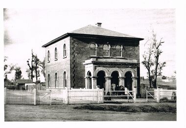
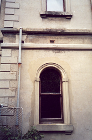
Photograph - WES HARRY COLLECTION: LAND OFFICE VIEW STREET
Black and white photo copy: image shows Survey office in View Street, known as Dudley House. Two storey brick building with verandah. Three arches in front portico facing street front. Picket fence on front of street, small buildings at rear.Batchelderplace, building, dudley house, bendigo, sandhurst, survey office, larritt, view street -
 Bendigo Historical Society Inc.
Book - 'BULLETINS OF THE GEOLOGICAL SURVEY OF VICTORIA NO. 30'. THE PEARL AND HERCULES AND ENERGETIC MINES, BENDIGO, 1914
Bulletins of the Geological Survey of Victoria No. 30. The Pearl and Hercules and Energetic Mines, Bendigo, with plans and sections. By W. Baraganath Underground maps of the 4 (four) mines referred to in this book. Priced six pence Inscribed on the front cover: A. Richardson, 29 Harrison Street, Bendigo.Department of Mines. By W. Baraganathbendigo, mining, early history., mining, pearl, hercules and energetic mines. -
 Bendigo Historical Society Inc.
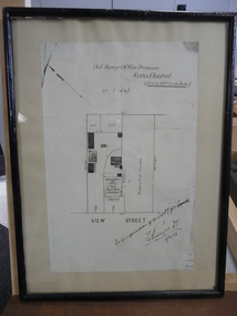
Document - DUDLEY HOUSE COLLECTION: PLAN OF DUDLEY HOUSE, 1888
Wooden framed copy of allotment plan of Old Survey Office Premises (Dudley House) Sandhurst, under glass in thin black wooden frame. Notation on bottom reads, For the information of the Secty for lands and signature of T.W.Pinniger D.S. (District Surveyor) 5/4/88T.W.Pinniger D.S.document, certificate, plan -
Bendigo Historical Society Inc.
Map - YARRAYNE : COUNTY OF BENDIGO, 6-1-32
Map. Yarrayne, County of Bendigo, Janiember Easr, Pompapiel, Salisbury, Bridgewater, Salisbury West, Powlett. Photo-Lithographed at the Department of Lands and Survey, Melbourne. Price 2/-. 6-1-32.By authority H.J. Green, Govt.Printer. (number 31 in map cupboard 1)H.J. Green, Govt.Printer.map, bendigo, yarrayne -
Bendigo Historical Society Inc.
Map - WANURP : COUNTY OF BENDIGO, 1-12-33
Map. Wanurp, County of Bendigo, Terrick Terrick East, Pannoobamawm, Milloo, Dingee, Mitiamo. Photo-Lithographed at the Dept. of Lands and Survey, Melbourne. Price 1/-. 1-12-33. By authority H.J. Green, Govt. Printer. (number 26 in map cupboard 1)H.J. Green, Govt. Printermap, bendigo, wanurp -
Bendigo Historical Society Inc.
Map - CORNELLA : COUNTY OF BENDIGO, 18-3-08
Map. Cornella, County of Bendigo, County of Rodney, Colbinabbin, Gobarup, Redcastle, Toolleen, Cornella Creek, Kangaroo Creek. Photo-Lithographed at the Department of Lands and Survey, Melbourne by T.F. McGauran. 18-3-08. Price 1/-. (number 122 in map cupboard 1)T.F. McGauranmap, bendigo, cornella -
Bendigo Historical Society Inc.
Map - TALAMBE : COUNTY OF BENDIGO, January 1956
Map. Talambe, County of Bendigo, Hayanmi, Dingee, Tandarra, Yallook, Pompapiel, Calivil. Drawn and reproduced at trhe Department of Lands and Survey, Melbourne. January 1956. Price 2/-. By authority W.M. Houston, Government Printer, Melbourne. (number 23 in map cupboard 1)W.M. Houston,Government Printer, Melbourne.map, bendigo, talambe -
Bendigo Historical Society Inc.
Map - WELLSFORD : COUNTY OF BENDIGO, 15-12-41
Map. Wellsford, County of Bendigo, Bagshot, Ellesmere, Axedale, Strathfieldsaye, Huntly, Sandhurst. Drawn and reproduced at the Dept. of Lands and Survey, Melbourne.15-12 41. Price 2/-. By authority H.E. Daw, Government Printer, Melbourne. (number 20 in map cupboard 1)H.E. Daw, Government Printer,Melbourne.map, bendigo, wellsford -
Bendigo Historical Society Inc.
Map - DERBY : COUNTY OF BENDIGO, 1-9-09
Map. Derby, County of Bendigo, Inglewood, Loddon River, Tarnagulla, Woodstock, Leichardt, Bridgewater, Bendigo to Inglewood Railway. Photo-Lithographed at the Department of Lands and Survey, Melbourne, by T.E. McGauran 1-9-09. Price 1/-. (number 55 in map cupboard 1)T.E. McGauranmap, bendigo, derby -
Bendigo Historical Society Inc.
Map - HUNTLY : COUNTY OF BENDIGO, August 1954
Map. Huntly, County of Bendigo. Whirrakee, Bagshot, Wellsford, Nerring, Neilborough, Township of Huntly. Drawn and reproduced at the Department of Lands and Survey, Melbourne, Victoria. August 1954. Price 2/-. By authority W.M. Houston, Government Printer. (number 42 in map cupboard 1)W.M. Houston, Govt. Printer.map, bendigo, huntly -
Bendigo Historical Society Inc.
Map - TALAMBE : COUNTY OF BENDIGO, 17-12-15
Map. Talambe, County of Bendigo, Hayanmi, Dingee, Tandarra, Yallook, Pompapiel. Photographed at the Department of Lands and Survey, Melbourne by W.J. Butson,17-12-15, Price 1/-. Albert J. Mullett, Govt. Printer, Melbourne. (number 17 in map cupboard 1)Albert J. Mullett, Government Printer, Melbourne.map, bendigo, talambe -
Bendigo Historical Society Inc.
Map - YARRABERB : COUNTY OF BENDIGO, 2-3-51
Map. Yarraberb, County of Bendigo, Salisbury, Yallook, Neilborough, Nerring, Leichardt, Bridgewater. L5373. By authority H.J. Green, Govt. Printer,Photo-Lithographed at the Deptartment of Lands and Survey, Melbourne. Price 2/-.2-3-51. (number 15 in map cupboard 1)H.J. Green, Govt. Printermap, bendigo, agricultural lands -
Bendigo Historical Society Inc.
Map - PANNOOBAMAWM : COUNTY OF BENDIGO, 1957
Map. Pannoobamawm, County of Bendigo. By Appointment W.M. Houston, Government Printer, Melbourne. Drawn and reproduced at the Department of Lands and Survey, Melbourne. Price 2/-.1957. Turrumberry, Terrick Terrick East, Wanurp,Pannoomilloo, Bamawm, Pannoobamawm. (number 2 in map cupboard 1)W.M. Houston, Government Printermap, bendigo, pannoobamawm -
Bendigo Historical Society Inc.
Map - NOLAN, COUNTY OF BENDOGO, 7-5-30
Map, Nolan, County of Bendigo, Egerton; Elmore; Goornong. Campaspe River, Elmore Estate, By Authority: H.J.Green, Government Printer,Melbourne.Price 2/-.Drawn and Reproduced at the Dept. of Lands and Survey,Melbourne,Victoria.7-5-30. (number 1 in map cupboard 1)H.J.Green,Government Printermap, bendigo, nolan -
Bendigo Historical Society Inc.
Map - NERRING : COUNTY OF BENDIGO, August 1952
Map. Nerring, County Of Bendigo. Yarraberb, Neilborough, Huntly, Sandhurst, Leichardt, Marong. Drawn and reproduced at the Department of Lands and Survey, Melbourne,Victoria. August 1952, Price 2/-. By Appointment J.J. Gourley, Government Printer, Melbourne. (number 0 in map cupboard 1)J.J. Gourley,Government Printermap, bendigo, nerring -
 National Vietnam Veterans Museum (NVVM)
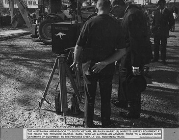
Photograph, Survey Equipment
A black and white photograph of The Australian Ambassador to South Vietnam, Mr Ralph Harry inspects survey equipment at the Phuoc Tuy Province Capital, Baria, with an Australian advisor prior to a Handing Over Ceramony Of Equipment, to the Provincial Chief Lt Col Nguyen Ba Truoc.photograph, mr ralph harry (australian ambassador to south vietnam), phuoc tuy province, baria, lt col nguyen ba truoc, gibbons collection catalogue -
 Villa Alba Museum
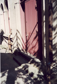
Photograph - Rear door from the alcove of the housekeeper's room, c.1987
Built for William and Anna-Maria Greenlaw in the early 1880s, and with interiors decorated by the Paterson Bros, Villa Alba remained in private ownership until 1949. From 1950, the house was owned by a number of institutions. By 1984, the Villa Alba Preservation Society had been formed, and three years later, the Mount Royal Hospital granted a 25-year lease to Kew Council. In 2004, the title to Villa Alba was passed by the Victorian Government to The Villa Alba Museum Incorporated. The Museum, at 44 Walmer Street, Kew, is now a cultural institution committed to the collection, study and display of 19th century interior decorative finishes, and the components of 19th and 20th century interior decoration.This is one of a number of historically and aesthetically significant photos of the interiors and exterior of Villa Alba when it was still owned by the Mount Royal Hospital, showing twentieth century accretions and deterioration of the historic fabric of the building. This was a benchmark survey against which future conservation and restoration activities can be measured.In December 1987, Mockridge Stahle & Mitchell Pty Ltd Architects prepared ‘Villa Alba Survey: A Report on the fabric for Mount Royal Hospital’ of which this photograph is a part. Photo of the painted wooden door leading from the alcove of the housekeeper's room at the back of Villa Alba.villa alba museum, conservation photographs, victorian architecture, external doors -
 Villa Alba Museum
Photograph - Ground and first floor windows, c.1987
Built for William and Anna-Maria Greenlaw in the early 1880s, and with interiors decorated by the Paterson Bros, Villa Alba remained in private ownership until 1949. From 1950, the house was owned by a number of institutions. By 1984, the Villa Alba Preservation Society had been formed, and three years later, the Mount Royal Hospital granted a 25-year lease to Kew Council. In 2004, the title to Villa Alba was passed by the Victorian Government to The Villa Alba Museum Incorporated. The Museum, at 44 Walmer Street, Kew, is now a cultural institution committed to the collection, study and display of 19th century interior decorative finishes, and the components of 19th and 20th century interior decoration.This is one of a number of historically and aesthetically significant photos of the interiors and exterior of Villa Alba when it was still owned by the Mount Royal Hospital, showing twentieth century accretions and deterioration of the historic fabric of the building. This was a benchmark survey against which future conservation and restoration activities can be measured.In December 1987, Mockridge Stahle & Mitchell Pty Ltd Architects prepared ‘Villa Alba Survey: A Report on the fabric for Mount Royal Hospital’ of which this photograph is a part. Photo of one of two arched, rendered widows with later additions such as exterior drain pipe and gate.villa alba museum, conservation photographs, victorian architecture, cement render, windows -
Whitehorse Historical Society Inc.
Map, Aerial photographs Nunawading, 1976
Department of Crown Lands and Survey, Melbourne, 1976 Project.Department of Crown Lands and Survey, Melbourne, 1976 Project. Runs 29 - 33 City of Nunawading. Frames numbered from South to North boundaries, each strip numbered from West to East. No index map. Sheets 30/8 and 30/9 missing.non-fictionDepartment of Crown Lands and Survey, Melbourne, 1976 Project. victoria. department of crown lands and survey, aerial photographs, nunawading, mitcham, blackburn, blackburn north, blackburn south, forest hill, vermont, vermont south, burwood east, box hill, ringwood -
 Hume City Civic Collection
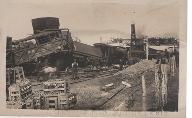
Photograph, 17th April 1919
On 17th April 1919 a stock train travelling north crashed head-on with a goods train coming in the opposite direction. The driver thought he had been given the all-clear to proceed into Sunbury and it was only when the train was approaching the Macedon Street bridge that he saw the red light and it was too late. The accident caused damage to rolling stack and disruption on the Bendigo and Maryborough lines. The train coming from Bendigo smashed onto the platform at Sunbury. The driver of the stock train was thrown under the van and suffered a broken arm and facial injuries. The fireman was thrown clear of the tracks. A local Sunbury doctor treated them before they were taken by a casualty train to hospital. A crew from Melbourne came to Sunbury to repair the damage. The track was cleared by that afternoon.This rail crash is one of a number that have happened in and near Sunbury over the years.A black and white photograph with a cream border, of a goods train smash at a railway siding. The carriages have 'jack-knifed'. Four men are on the tracks looking at the damage while a number of onlookers are surveying the damage from a footbridge. There are boxes of rabbit carcasses in crates stacked in the foreground.rail crashes, sunbury -
Bendigo Historical Society Inc.
Plan - SANDHURST BOYS CENTRE SITE PLANS: LISLE STREET UNITS
16 Working drawings including Floor Plans and Elevations Prepared by Michael DeVincentis, Architects; Wellington St Strathfieldsaye. October-November 1995. Scale 1:200. No 9538. Also Survey Plan for Lot 69D 3950 Sq m. Location unknown 16.02.2023.plan, bendigo, institutions, victoria. department of planning and development -
 Bendigo Historical Society Inc.
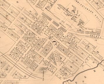
Map - MARKS COLLECTION: MAP SANDHURST 1867
Original map: Sandhurst 1867, shows central Bendigo and surrounds, including police camp, stockade, 'old cemetery', reserve for. On bottom of map: 'Lithographed at the Department of Lands and Survey by D. Henderson, 20 February, 1867'. On top RH corner 'Sheet No 1 Sandhurst'.map, bendigo, 1867 sandhurst map -
Bendigo Historical Society Inc.
Book - BELL TOPPER - THE SCHOOL ON THE HILL, 1985
54 page spiral bound soft brown cover book entitled 'Bell Topper, the School on the Hill. A Survey of Parental and Community Attitudes to Education at California Gully Primary School'. By Dr.A.Dudley and A.Potts of the Faculty of Education, Bendigo C.A.E. The study undertaken in Nov 1985.A.Dudley & A. Potts -
 Bendigo Historical Society Inc.
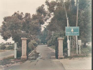
Photograph - FORTUNA COLLECTION - PHOTOGRAPH
Colour photograph of front entrance gate, with 2 column stone like pillars either side, and driveway to Fortuna Villa property, a sign to the right hand side of entrance reads ' Army Headquarers Survey Regiment' along with 2 smaller lines of writing underneath. -
 Bendigo Historical Society Inc.
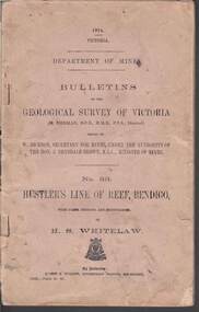
Book - STRUGNELL COLLECTION: DEPARTMENT OF MINES: 1914 GEOLOGICAL SURVEY OF VICTORIA. HUSTLERS LINE OF REEF, 1914
Book, Department of Mines, Bulletins of the Geological Survey of Victoria, No.33, Hustler's Line Of Reef, Bendigo, with plans,sections, and photographs, by H.S.Whitelaw. 13833, Price 2s.6d.`Back cover shows J.A. and J.A Strugnell , 12 Mulbar St Swan Hill 3585 .Albert J. Mullett, Government Printer, Melbourne.book, bendigo, hustler's line of reef -
 Lakes Entrance Regional Historical Society (operating as Lakes Entrance History Centre & Museum)
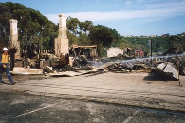
Photograph - Club Hotel Fire, LERHS, 2000
Date made December 2000Colour photograph showing aftermath of the fire at the Club Hotel. Photo taken from the carpark left foreground. Foreground shows fire brigade member surveying debris for outbreaks. Two brick chimneys remain standing, surrounding trees untouched. Lakes Entrance Victoriahotels, fire brigade, disasters -
 Bendigo Military Museum
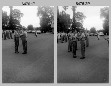
Photograph - Officer Commissioning and CO’s Handover Parade, Army Survey Regiment, Fortuna Villa, Bendigo, 1992
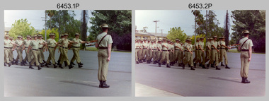
This is a set of 28 photographs taken at a CO’s Parade at the Army Survey Regiment, Fortuna, Bendigo in 1992. On this parade WO1 Bill Jones received his commission and by promotion to Captain from CO LTCOL Rene van den Tol. Command of the unit was handed over to LTCOL Rob McHenry. It is probable the commissioning and handover ceremonies occurred on the CO’s Parade. LTCOL Rene van den Tol was CO from 1989 to 1992 and LTCOL Rob McHenry was CO from 1992 to 1993.This is a set of 28 photographs taken at a CO’s Parade at the Army Survey Regiment, Fortuna, Bendigo in 1992. The colour photographs are on 35mm negative film and scanned at 96 dpi. They are part of the Army Survey Regiment’s Collection. .1) - Photo, colour, 1992. Headquarters Squadron marches past RSM WO1 Graham Ragless. .2) - Photo, colour, 1992. Cartographic Squadron marches past RSM WO1 Graham Ragless. L to R: unidentified personnel, WO2 Steve Hansen, CPL Roger Pearson, WO1 Gary Warnest, SSGT Dennis Learmonth, SSGT Greg Else, CPL Ian Bowes, SGT Stuart Symonds. .3) - Photo, colour, 1992. Lithographic Squadron marches past RSM WO1 Graham Ragless. L to R: unidentified personnel, WO1 Steve Egan, LCPL John Bragg, unidentified personnel, WO2 Rob Bogumil, unidentified personnel, SPR Corey Hill. .4) - Photo, colour, 1992. Air Survey Squadron marches past RSM WO1 Graham Ragless. L to R: unidentified personnel, WO1 Allan Hancox, SSGT Wolfgang Thun, unidentified personnel, WO2 Neil ‘Ned’ Kelly, unidentified personnel, SGT Dave Longbottom, SGT Brian Johnson. .5) - Photo, colour, 1992. Cartographic Squadron. L to R: unidentified personnel, SGT Stuart Symonds, CPL Col McInnes, CAPT Mary Anne Martinek in foreground, SPR Jodi Seith, unidentified personnel, SPR Avril (Bray) Lloyd. .6) - Photo, colour, 1992. Air Survey Squadron. L to R: unidentified officer, SSGT Bruce Hammond, SPR Tracy Tillman, SPR Rachel (Stanford) Scott, SPR Paula (Golding) Brinsmead, SGT Graeme Reany, unidentified officer in foreground, unidentified personnel, CPL Steve Coulson. .7) - Photo, colour, 1992. Cartographic Squadron inspection. L to R: RSM WO1 Graham Ragless, unidentified, OC MAJ Graeme Wastell, CO LTCOL Rene van den Tol, unidentified personnel, CPL Col McInnes, SPR Jodi Seith, SPR Avril (Bray) Lloyd. CPL Steve Ellis, SPR Ian Brown, SPR Andrew Lazdovskis. .8) - Photo, colour, 1992. Cartographic Squadron inspection. L to R: OC MAJ Graeme Wastell, CO LTCOL Rene van den Tol, SPR Avril (Bray) Lloyd, CPL Steve Ellis, SPR Ian Brown, SPR Andrew Lazdovskis, SPR Adrian Taylor, unidentified, SPR Mick Knight, SPR Dawn Hoadley, CPL Craig Kellet. .8) to .12) - Photo, colour, 1992. Officer Commissioning Ceremony. L to R: CO LTCOL Rene van den Tol, WO1 Bill Jones promoted to Captain. .13) - Photo, colour, 1992. Officer Commissioning Ceremony. L to R: ADJT CAPT Geoff Ford, RSM WO1 Graham Ragless, CO LTCOL Rene van den Tol, WO1 Bill Jones promoted to Captain. .14) - Photo, colour, 1992. Officer Commissioning Ceremony. WO1 Bill Jones promoted to Captain. .15) - Photo, colour, 1992. Commanding Officer Handover. CO LTCOL Rene van den Tol delivers speech. .16) to .17) - Photo, colour, 1992. Commanding Officer Handover. R to L: CO LTCOL Rene van den Tol hands over to incoming CO LTCOL Rob McHenry. .18) - Photo, colour, 1992. Commanding Officer Handover. L to R: RSM WO1 Graham Ragless, ADJT CAPT Geoff Ford, CO LTCOL Rob McHenry. .19) - Photo, colour, 1992. Commanding Officer Handover. L to R: ADJT CAPT Geoff Ford, RSM WO1 Graham Ragless, CO LTCOL Rob McHenry. .20) - Photo, colour, 1992. Cartographic Squadron marches off parade ground. L to R: OC MAJ Graeme Wastell, unidentified officer, CAPT Greg Oaten, LT Matt Jackson, CAPT Mary Anne Martinek, SPR Mick Knight. .21) & .22) - Photo, colour, 1992. Cartographic Squadron marches off parade ground. .23) - Photo, colour, 1992. Lithographic Squadron marches off parade ground. L to R: OC Bob Coote, unidentified officer, SPR Scott Cameron, unidentified officer, SSGT Russ Mollenhauer, SGT Brian Fauth. .24) - Photo, colour, 1992. Lithographic Squadron marches off parade ground. L to R: LCPL Janet Murray, unidentified, SPR Mick Muzeen, Allison (Ottaway) Wooldrage, SGT Keith Quinton, SGT Frank Lenane, SGT Laurie Justin, SGT Dale Hudson, LCPL John Bragg, unidentified, SGT Kim Reynolds, SPR Corey Hill, SPR Andrew Arman, SPR Ross Anza, WO1 Peter Coombes. .25) - Photo, colour, 1992. Parade guests. L to R: unidentified guests, MAJ Peter Jensen. .26) - Photo, colour, 1992. Parade guests. L to R: unidentified guests, CAPT Doug Arman, unidentified guests. .27) - Photo, colour, 1992. Parade personnel march off. L to R: unidentified, WO2 Ted Burgess, WO1 Ken Slater. .28) - Photo, colour, 1992. Parade personnel. L to R: unidentified, SPR Allan Blake..1P to .28P – There are no annotations.royal australian survey corps, rasvy, army survey regiment, army svy regt, fortuna, asr -
 Bendigo Military Museum
Administrative record - 1 Fd Svy Sqn Production Report - Carto Hydra Phase 2 1985, 13 may 1985
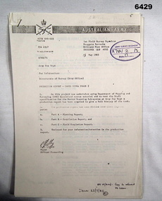
Report produced by 1 Fd Svy Sqn 13 May 1985 of Carto Hydra Phase 2. This project was undertaken using Department of Mapping and Surveying (DMS) Queensland source material and to test the Draft specifications for the Raster Scanning Sub-System at the Army Survey Regiment. This production Report has been compiled to give a full record of the task.photocopy of an A4 typed report produced by 1 Fd Svy Sqn royal australian survey corps, rasvy, fortuna, army survey regiment, army svy regt, asr, 1 fd svy sqn -
 Bendigo Military Museum
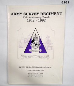
Booklet - Army Survey Regiment - 50th Anniversary Parade 1942-1992, Army Survey Regiment, March 1992
The booklet contains the programme for the Army Survey Regiment's 50th Anniversary Parade. Contains pen portraits of the Director of the Royal Australian Survey Corps, a history of the Corps, the City of Bendigo current and former Mayors, details of the Parade, various prayers, Directors of the Corps, Corps Colonel Commandants, Army Svy Regt Commanding Officers and a Nominal Role of Regt personnel.A4 soft covered booklet, glossy light card cover, paper pages, stapled. Unit Plaque design on cover.royal australian survey corps, rasvy, fortuna, army survey regiment, army svy regt, asr -
 Bendigo Military Museum
Photograph - Army Survey Regiment – CO’s Parade and Defence Force Service Medal Presentations, Fortuna, Bendigo, 1985
This set of 20 photographs were taken at a CO’s parade at the Army Survey Regiment, Bendigo in 1985. CO LTCOL Jorge Gruszka presented the Defence Force Service Medal to personnel in recognition of 15 years of efficient remunerated service, or the Clasp for 5 years of additional service. WO2 Russ Larsen’s Warrant was also presented at the parade. This is a set of 20 photographs of a CO’s parade and the presentation of the Defence Force Service Medal, at the Army Survey Regiment, Bendigo in April 1985. The black & white photographs are on 35mm negative film and are part of the Army Survey Regiment’s Collection. The photographs were scanned at 96 dpi. .1) - Photo, black & white, 1985. CO LTCOL Jorge Gruszka presents medal to MAJ Bob Roche. .2) - Photo, black & white, 1985. CO LTCOL Jorge Gruszka presents medal to WO2 Brian Partridge. In foreground L to R: SSGT Doug Gay, SSGT Peter Tangey, SGT Wally Chilcott. In background L to R: CPL Dan Cirsky, SPR Steve Coulson. .3) & .4) - Photo, black & white, 1985. CO LTCOL Jorge Gruszka presents medal to RSM WO1 Bob Mason. In foreground L to R: WO1 Dave Thomson, unidentified (x2), far right: CPL Paul Baker. In background L to R: CPL Ian Bowes, CPL Dan Cirsky, SPR Steve Coulson, MAJ Roger Rix. .5) & .6) - Photo, black & white, 1985. CO LTCOL Jorge Gruszka presents medal to WO1 Dave Thomson. In foreground: unidentified. In background L to R: CPL Ian Bowes, SPR Scott Payne, CPL Dan Cirsky, SPR Steve Coulson, MAJ Roger Rix. .7) & .8) - Photo, black & white, 1985. CO LTCOL Jorge Gruszka presents medal to WO1 Noel ‘Nesty’ Coulthard. In foreground L to R: WO2 Kevin Quinnell, WO2 Brian Partridge, SSGT Doug Gay, SSGT Peter Tangey, SGT Greg Anderson, SGT Wally Chilcott. .9) & .10) - Photo, black & white, 1985. CO LTCOL Jorge Gruszka presents medal to WO1 Bill Griggs. In foreground L to R: WO2 Kevin Quinnell, WO2 Brian Partridge, SSGT Doug Gay, SSGT Peter Tangey, SGT Greg Anderson, SGT Wally Chilcott. .11) & .12) - Photo, black & white, 1985. CO LTCOL Jorge Gruszka presents medal to WO2 Kevin Quinnell. In foreground L to R: WO2 Brian Partridge, SSGT Doug Gay, SSGT Peter Tangey, SGT Greg Anderson, SGT Wally Chilcott. .13) & .14) - Photo, black & white, 1985. CO LTCOL Jorge Gruszka presents medal to SSGT Doug Gay. In foreground L to R: SSGT Peter Tangey, SGT Greg Anderson, SGT Wally Chilcott. .15) & .16) - Photo, black & white, 1985. CO LTCOL Jorge Gruszka presents medal to SSGT Peter Tangey. In foreground: L to R: SGT Greg Anderson, SGT Wally Chilcott. .17) - Photo, black & white, 1985. CO LTCOL Jorge Gruszka presents medal to SGT Greg Anderson. In foreground: SGT Wally Chilcott. In background L to R: SPR Eric Nicholson, CPL Ian Bowes, SPR Scott Payne CPL Dan Cirsky, SPR Steve Coulson. .18) - Photo, black & white, 1985. CO LTCOL Jorge Gruszka presents medal to SGT Wally Chilcott. In background L to R: SPR Eric Nicholson, CPL Ian Bowes, SPR Scott Payne CPL Dan Cirsky, MAJ Roger Rix. .19) - Photo, black & white, 1985. CO LTCOL Jorge Gruszka presents medal to unidentified recipient. In background L to R: SPR Scott Payne CPL Dan Cirsky, SPR Steve Coulson, MAJ Roger Rix. .20) - Photo, black & white, 1985. CO LTCOL Jorge Gruszka presents Warrant to WO2 Russ Larsen. In background L to R: unidentified, SPR Eric Nicholson, CPL Ian Bowes, CPL Dan Cirsky, SPR Steve Coulson, MAJ Roger Rix. Far right foreground: RSM WO1 Bob Mason.There are no personnel identified. Date and occasion annotated on film negative sleeve.royal australian survey corps, rasvy, army survey regiment, army svy regt, fortuna, asr