Showing 1526 items
matching aerial photograph
-
 National Wool Museum
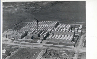
Photograph - Valley Worsted Mill, 1923
Photographic postcard depicting the newly constructed Valley Worsted Mill, c.1923.Photographic postcard, black and white. Depicts an aerial view of the newly constructed textile mill. A chimney stack and many saw toothed roofs can be seen.POST CARD / CORRESPONDENCE ADDRESS ONLY / KODAK / AUSTRALtextile mills, valley worsted mill foster valley mill pty ltd, aerial photography, factory, wool, industrial building -
 National Wool Museum
Photograph
Photographic postcard depicting the newly constructed Valley Mill, c.1923.Aerial view of the Valley Mill, c.1923.POST CARD / CORRESPONDENCE ADDRESS ONLY / KODAK / AUSTRALvalley worsted mill -
 National Wool Museum
Photograph
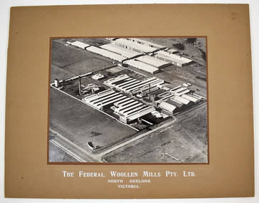
Black and white mounted photograph of the Federal Woollen Mill Pty Ltd, North Geelong, Victoria - aerial view showing all buildings and grounds which includes 2 tennis courts in the background and 1 basketball court in the foreground. Negative and proof available currently held as film 48 frame 18.Black and white mounted photograph of the Federal Woollen Mill Pty Ltd, North Geelong, Victoria.The Federal Woollen Mills Pty. Ltd. North Geelong Victoriawoollen mills history, federal woollen mills ltd, woollen mills - history -
 Whitehorse Historical Society Inc.
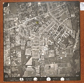
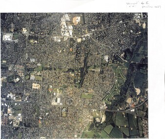
Map, Aerial Photographs Nunawading, 1970
... attached. State Aerial Survey Aerial photographs Nunawading Mitcham ...State Aerial Survey, Melbourne 1970.State Aerial Survey, Melbourne 1970. Project runs 34 - 39 - City of Nunawading. Frames numbered from South to North boundaries, each strip numbered from East to West. See table of index and photo numbers attached.non-fictionState Aerial Survey, Melbourne 1970.state aerial survey, aerial photographs, nunawading, mitcham, blackburn, blackburn north, blackburn south, forest hill, vermont, burwood east, vermont south -
Whitehorse Historical Society Inc.
Map, Aerial photographs Nunawading, 1972
... Lands and Survey Aerial photographs Nunawading Mitcham Blackburn ...Department of Crown Lands and Survey, Melbourne, 1972.Department of Crown Lands and Survey, Melbourne, 1972. Project runs 34 - 39 - City of Nunawading. frames numbered from South to North boundaries, each strip numbered from West to east. The series extends further West to Box Hill and East to Ringwood than the 1970 project. No index map. Sheets 39/2 and 34/28 missing.non-fictionDepartment of Crown Lands and Survey, Melbourne, 1972.victoria. department of crown lands and survey, aerial photographs, nunawading, mitcham, blackburn, blackburn north, blackburn south, forest hill, vermont, burwood east, box hill, ringwood, vermont south -
Whitehorse Historical Society Inc.
Map, Aerial photographs Nunawading, 1976
... . Department of Crown Lands and Survey Aerial Photographs Nunawading ...Department of Crown Lands and Survey, Melbourne, 1976 Project.Department of Crown Lands and Survey, Melbourne, 1976 Project. Runs 29 - 33 City of Nunawading. Frames numbered from South to North boundaries, each strip numbered from West to East. No index map. Sheets 30/8 and 30/9 missing.non-fictionDepartment of Crown Lands and Survey, Melbourne, 1976 Project. victoria. department of crown lands and survey, aerial photographs, nunawading, mitcham, blackburn, blackburn north, blackburn south, forest hill, vermont, vermont south, burwood east, box hill, ringwood -
Whitehorse Historical Society Inc.
Map, Canterbury Road, Vermont, c1970
... Photographs Enlarged aerial photo of intersection of Canterbury ...Enlarged aerial photo of intersection of Canterbury and Boronia Roads. State Aerial Survey, Melbourne 1970 project.Enlarged aerial photo of intersection of Canterbury and Boronia Roads. State Aerial Survey, Melbourne 1970 project.Enlarged aerial photo of intersection of Canterbury and Boronia Roads. State Aerial Survey, Melbourne 1970 project.canterbury road, vermont, boronia road, vermont, mitcham road, vermont, frances avenue, vermont, nurlendi road, vermont, webb court, vermont, vermont primary school, no. 1022, aerial photographs -
Whitehorse Historical Society Inc.
Map, Highbury Road, c1970
... Photographs Enlarged aerial photo of Highbury Park area. Enlarged ...Enlarged aerial photo of Highbury Park area.Enlarged aerial photo of Highbury Park area.Enlarged aerial photo of Highbury Park area.highbury road, burwood east, gareth drive, burwood east, blackburn road, burwood east, bennett avenue, burwood east, rae street, burwood east, joy street, burwood east, folkestone road, burwood east, burwood east primary school no. 454, aerial photographs -
Whitehorse Historical Society Inc.
Map, Springvale Road, c1970
... Nunawading Maroondah Highway Nunawading Aerial photographs Enlarged ...Enlarged aerial photo of intersection of Springvale and Whitehorse Roads, Nunawading.Enlarged aerial photo of intersection of Springvale and Whitehorse Roads, Nunawading.Enlarged aerial photo of intersection of Springvale and Whitehorse Roads, Nunawading.springvale road, nunawading, whitehorse road, nunawading, maroondah highway, nunawading, aerial photographs -
Whitehorse Historical Society Inc.
Map, Burwood Highway, c1970
... Burwood Highway Vermont South Aerial photographs Enlarged aerial ...Enlarged aerial photo of area South of Burwood Highway to Dandenong Creek, Vermont South.Enlarged aerial photo of area South of Burwood Highway to Dandenong Creek, Vermont South.Enlarged aerial photo of area South of Burwood Highway to Dandenong Creek, Vermont South.dandenong creek, morack road, vermont south, burwood highway, vermont south, aerial photographs -
Whitehorse Historical Society Inc.
Map, Mitcham Road, c1970
... School No. 2904 Aerial photographs Enlarged aerial photo ...Enlarged aerial photo of the intersection of Mitcham and East Doncaster Roads, Mitcham. Scale 1 inch : 40 feet.Enlarged aerial photo, c1970, of the intersection of Mitcham and East Doncaster Roads, Mitcham. Scale 1 inch : 40 feet.Enlarged aerial photo of the intersection of Mitcham and East Doncaster Roads, Mitcham. Scale 1 inch : 40 feet.mitcham road, mitcham, quarry road, mitcham, doncaster east road, mitcham, wooddale grove, mitcham, mitcham primary school, no. 2904, aerial photographs -
Whitehorse Historical Society Inc.
Map, Aerial maps, 2/04/1966 12:00:00 AM
... Mitcham melbourne aerial photographs blackburn blackburn south ...Melbourne 1966 project, runs 10A and 11A, lens 122 151.75 mm 9,800. Photo nos 77, 107, 109, 161, 163, 165.Melbourne 1966 project, runs 10A and 11A, lens 122 151.75 mm 9,800. Photo nos 77, 107, 109, 161, 163, 165. Areas and boundaries: Map no 77 W. Park and Cook Roads; E. Dubon Rd; N Oban Rd; S Reilly St. Map No 107. W. Indra Rd and Pakenham St; E. Rooks Rd & McLares Rd; N. Maroondah Hwy; S. Hawthorn Rd & Eley Rd. Map No 109 W. Elgar Rd. E. Blackburn Rd & McKean St; S. Eley Rd & Burwood Hwy. Map No 161. W. Elgar Rd & Huntingdale Rd; E. Blackburn Rd; N. Burwood Hwy; S. Waverley Rd. Map No 163. W. Blackburn Rd; S. Springvale Rd; N. Eley Rd & Hawthorn Rd; S. Glen Waverley Railway Line. Map No 165. W. Stanley Rd, Vermont South; E. Cathies Lane, Wantirna South; N. North of Burwood Hwy; S. High Street. Melbourne 1966 project, runs 10A and 11A, lens 122 151.75 mm 9,800. Photo nos 77, 107, 109, 161, 163, 165. aerial photographs, blackburn, blackburn south, forest hill, nunawading, box hill, burwood, burwood east, donvale, mount waverley, glen waverley, wantirna, vermont south, mitcham, ringwood north, ringwood -
 Whitehorse Historical Society Inc.
Map, Photo-map Ringwood A4A, 1945
... Mitcham melbourne aerial photographs box hill blackburn nunawading ...Aerial photo covering approximately from Box Hill to Mitcham (West to East) and Springfield Road to Hawthorn Road (North to south).Aerial photo covering approximately from Box Hill to Mitcham (West to East) and Springfield Road to Hawthorn Road (North to south). Names of main roads inscribed.Aerial photo covering approximately from Box Hill to Mitcham (West to East) and Springfield Road to Hawthorn Road (North to south).aerial photographs, box hill, blackburn, nunawading, forest hill, mitcham -
Whitehorse Historical Society Inc.
Document, 520 Mitcham Road, 2005
Papers relating to objections to development of 520-528 Mitcham Road Mitcham.Papers relating to objections to development of 520-528 Mitcham Road Mitcham. Includes: statement by Neil Edwin Kerby & Margaret Anne Kerby; Title searches for 449 Mitcham Road Mitcham and adjacent properties; plan of 1906 subdivision; ASIC extract of development company organisational details; aerial photos of the area; photographs of nearby properties and of Mitcham Road streetscapes and list of Mitcham objectors. CD copy at NP3771Papers relating to objections to development of 520-528 Mitcham Road Mitcham. mitcham road mitcham, nos. 520-528, kerby, neil edwin, kerby, margaret anne, mitcham road mitcham no. 449, 520 mitcham road pty ltd, listermay nominees pty ltd, land subdivision -
 Whitehorse Historical Society Inc.
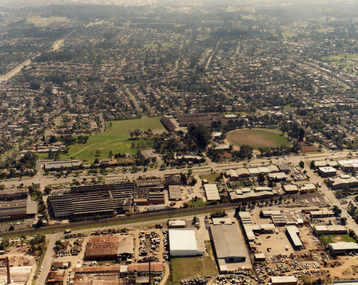
Photograph, Tally Ho Industrial Park, C.1995
Aerial Photo of Tally Ho Industrial Park. East Burwood Reserve and the Bill Sewart Athletic Track is in centre.tally ho industrial park, lend lease development pty ltd, east burwood reserve, bill sewart athletic track -
 Whitehorse Historical Society Inc.
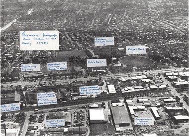
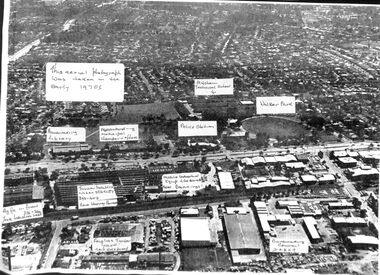
Photograph, Aerial View of various sites in Nunawading, C.1970's
2 Black and white copies of Aerial View of various sites in Nunawading. - Mitcham Technical School, Walker Park , Nunawading Police Station, Bunnings Warehouse, Mobile Industrial Equipment Ltd, Municipal Chambers, Nunawading Library, Turner Industries, Harvey Norman, Feiglins Timber Yard, Holeproof ,Agfa, York Industries and|City of Nunawading. Council Depot.mitcham technical school, walker park, nunawading police station, bunnings warehouse nunawading, mobile industrial equipment ltd., city of nunawading. council chambers, nunawading library, turner industries, harvey norman, feiglins timber yard, holeproof, agfa, york industries, city of nunawading. council depot -
 Whitehorse Historical Society Inc.
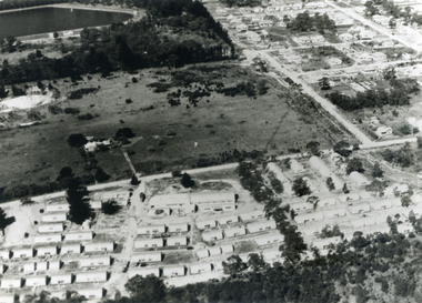
Photograph, Aerial View - Eastbridge Hostel, 1953
... . Aerial View - Eastbridge Hostel Photograph Photograph ...Black and white Aerial View of Eastbridge Migrant Hostel in Rooks Road, Nunawading (since demolished) taken in 1953. Donor's Family was first Family in Eastbridge and Donor was Housekeeper there for 2 years.jones, mrs, eastbridge migrant hostel -
 Whitehorse Historical Society Inc.
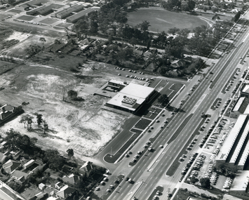
Photograph, Tally Ho Office Park, 1995
Aerial view of Tally Ho Office Park on corner of Springvale Road & Burwood Highway, East Burwood. Site partly developed. Shows East Burwood Reserve (part) and Bill Sewart Athletics Track. Photo taken facing Burwood Highway.lend lease development pty ltd, tally ho office park, springvale road burwood east, burwood highway burwood east, bill sewart athletic track -
 Whitehorse Historical Society Inc.
Photograph, Aerial View of Mitcham, C.1925
... . and their Quarry. Aerial View of Mitcham Photograph Photograph ...Large Aerial View of Mitcham showing Railway and South side. In particular, The Australian Tesselated Tile Co. Works and Quarry. Also Monarch Works, better known as Builders' Trade and Roofing Co. and their Quarry.australian tesselated tile co. pty ltd, aerial photographs, monarch pottery, builders trading and roofing co. ltd -
 Whitehorse Historical Society Inc.
Photograph, Aerial View of Vermont, 1968
... of Vermont. Mounted on Board. Aerial View of Vermont Photograph ...Black and white Aerial View of Vermont. Mounted on Board.gray, andrew -
 Whitehorse Historical Society Inc.
Photograph, Aerial View of Vermont and surrounding area
3 Copies of Aerial View of Vermont and surrounding area.vermont, arial view -
 Whitehorse Historical Society Inc.
Photograph, Nunawading Council Chambers
Coloured photo of Aerial view of Nunawading Council Chambers and librarymunicipal chambers, city of nunawading. council chambers, nunawading library -
 Whitehorse Historical Society Inc.
Photograph, Nunawading Civic Centre
Black and white photo of aerial view of Nunawading Civic Centre. 1 copynunawading civic centre, whitehorse civic centre -
 Whitehorse Historical Society Inc.
Photograph, Aerial View of Site for Nunawading Civic Centre, 12/06/1968 12:00:00 AM
Black and white photo of Aerial View of Site for Nunawading Civic Centre.nunawading civic centre -
 Whitehorse Historical Society Inc.
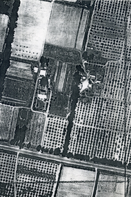
Photograph, Aerial View of Matheson Orchard, 1944
Poor photo copy of black and white photo of Aerial View of Matheson Orchard 'Strathdon', Springvale Road , Forest Hill.matheson, strathdon orchard, orchards -
 Rutherglen Historical Society
Newspaper - Image
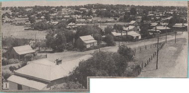
One of a group of photographs of Rutherglen collected from magazines (Pix or People or Post), then pasted onto orange paper, date unknown. This one is an aerial view of Rutherglenrutherglen -
 Ballarat Heritage Services
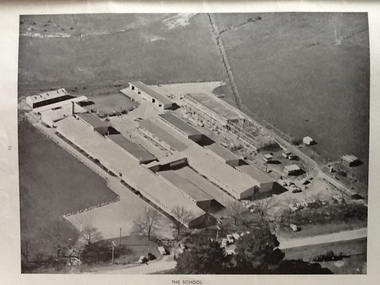
Photograph - Black and White, Ballarat East High School, aerial photographs
... East High School, aerial photographs Photograph - Black ...Three black and white photographs of the Ballarat East High School. ballarat east high school, education -
 Ballarat Heritage Services
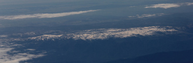
Digital photographs, L.J. Gervasoni, Australian Alps snow capped, 2017
australian alps, snow capped, aerial -
 Ballarat Heritage Services
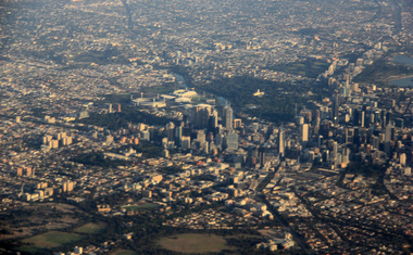
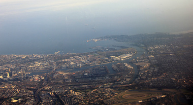
Digital Photograph, L.J. Gervasoni, Melbourne CBD on approach Melbourne Airport, 2016, 2016
Colour photorgraph showing the Melbourne Business District from the air.aerial, melbourne, cbd, domain, cityscape, parklands -
 Ballarat Heritage Services
Digital Photograph, L.J. Gervasoni, Melbourne CBD on approach Melbourne Airport, 2016, 2016
Digital Image showing the Melnourne Business District from the air.aerial, melbourne, mouth, yarra river, west gate bridge, inner west