Showing 2127 items
matching map of bendigo
-
 Bendigo Historical Society Inc.
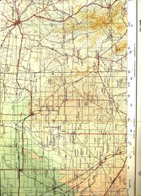
Map - ST ARNAUD MAP, 1968
... Inc. History House 11 Mackenzie Street Bendigo goldfields MAP ...Colour map of St Arnaud district printed by Royal Australian Survey Corps 1968Royal Australian Survey Corpsmap, victoria, starnaud -
 Bendigo Historical Society Inc.
Map - RAILWAY POSTAL & TELEGRAPH MAP OF VICTORIA, 1887
... Inc. History House 11 Mackenzie Street Bendigo goldfields MAP ...Railway Postal & Telegraph Map of Victoria 1887 printed on canvas in a fold out book form with name printed on back F.L.Outtrim, in a cardboard cover with red and blue pattern.Picturesque Atlas Publishing Co Ltd Sydney & Melbournemap, victoria, railway -
 Bendigo Historical Society Inc.
Ephemera - LYDIA CHANCELLOR COLLECTION: EPHEMERA
A wide variety of items all in a damaged and incorrectly labelled tennis ball box. It is labelled 'Authors Book Reviews.' Some items are ephemeral others are of historical importance. (I) A black exercise book titled 'Correspondence Golden Square Patriotic League.' Lydia Pethard Hon. Sec. This book has pages labelled 'inwards' and 'outwards' and details correspondence between Aug. 2nd 1918 and C1921. (II) A Secondary Infantry Bendigo Brigade Comforts Fund cash book. 1919. (III) A black exercise book titled 'Golden Square Patriotic League.' Contains the minutes of meetings held between November 26th, 1917 and August 5th, 1918. Also includes the 'Annual Report p resented at Public Meeting held August 15th, 1918 and presented by President Lydia Pethard, Hon. Sec. (IV) A black exercise book labelled 'Wilsons' Reed Branch 2nd Infantry Comforts Fund. Mrs. Geo Goulden. It contains information relevant to the members and is dated 26/7/17 to 28/12/18 and 3/8/17 to 13/12/18. In the centre of the book is a list of donations. (V) A black exercise book titled 'Red Cross Golden Square.' Contains meetings held from June 30th, 1915 to October 29th., 1917. (VI) A small black notebook titled 'Carnival Returns July 21st 1917.' Appears to pertain to raffle tickets. (VII) 20 booklets titled 'Austral-American Souvenir. The Glorious Fourth.' Reprinted in connection with Bendigo-Eaglehawk Australian Comforts Fund Effort, 4th July, 1918. Written in connection with the visit of the American fleet August 1908 (VIII) A small cream sympathy card for a lost soldier Bendigo, Oct., 1918. (VX) A small blue and white election advertisement urging 'yes' for Reinforcements on Dec. 20th. (X) 2 copies of the Australian Comforts Fund Bendigo Appeal June-July 1916 Receipts. (XI) 2 copies of an application for authority to make an appeal, or to collect. Pertaining to Patriotic Funds. (XII) 2 copies of parcel slips 'for our Australian Troops From the Lady Mayoress's Patriotic League.' (ix) small card circ 1917 -A christmas flash from the boys in the trenches -on Dec 20th for Reinforcements Hold up the light -the front of the card shows a picture of three soldiers in a trench shining a searchlight on a map of Australia .The back shows a searchlight with the words -vote yes - Authorised by the Reinforcements Referendum Councilorganization, club / society, australian comforts fund, lydia chancellor, collection, ephemera, golden square patriotic league, bendigo brigade comforts fund, wilsons' reed branch 2nd infantry comforts fund, red cross golden square, bendigo-eaglehawk australian comforts fund, war, world war i, clubs, clubs and societies, organizations, finance, history, australian history, australian comforts fund -
 Bendigo Historical Society Inc.
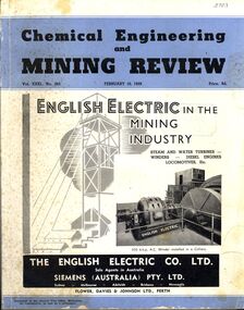
Book - CHEMICAL ENGINEERING AND MINING REVIEW, February 10th, 1939
Chemical Engineering and Mining Review February, 10th 1939 with photographs, maps and illustrations.books, technical, mining -
 Bendigo Historical Society Inc.
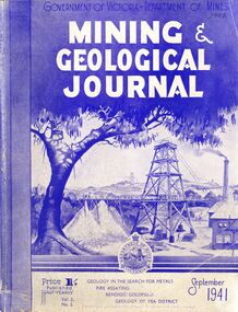
Book - MINING & GEOLOGICAL JOURNAL, September, 1941
Mining & Geological Journal September 1941, Geology in the search for metals, fire assaying, Bendigo goldfields, Geology of Yea district published half yearly by the Department of Mines Victoria contains photographs, maps and illustrations.gold, mining, journal -
 Bendigo Historical Society Inc.
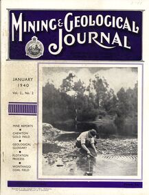
Book - MINING & GEOLOGICAL JOURNAL, 1940
Mining & Geological Journal January 1940 Vol.2 No.2 Mine reports Chewton Gold Field, Geological Glossary, Flotation Process, Wonthaggi Coal Field published hald yearly by he Department of Mines Victoria contains photographs, maps and illustrations.gold, mining, journal -
 Bendigo Historical Society Inc.
Document - JAMES LERK COLLECTION: BENDIGO CENTRAL BOTTLE CLUB NEWSLETTER
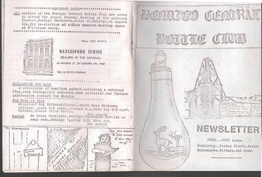
Bendigo Central Bottle Club Newsletter - James Lerk Collection (June /July 1976). Article on ''Old Inglewood'' (by Ken Arnold) - information on 1858 - 1860s with sketch map of gullies in area; Reference to bottle of T R Jones, Chemist of Bendigo (Pall Mall, near Allans Walk); list of some other bottle manufacturers in Bendigo. -
 Bendigo Historical Society Inc.
Document - JAMES LERK COLLECTION: BENDIGO CENTRAL BOTTLE CLUB NEWSLETTER
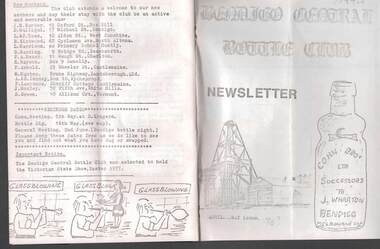
... Bendigo Central Bottle Club Newsletter - James Lerk... being once a main thoroughfare to Bendigo (with sketch map ...Bendigo Central Bottle Club Newsletter - James Lerk Collection (April 1976 by deduction). Reference to William Brude store owner/wine and spirit merchant. Involved in partnership in London Brewery and owned Norfolk Brewery - includes list of various bottles owned and used by William Bruce. Reference to Sheepwash being once a main thoroughfare to Bendigo (with sketch map) and information on two of the seven vineyards in area by 1855 - A. Derivan (sic) De Ravin and William Jones, Wine Merchant; article on Bendigo Breweries - reference in it to Albion Brewery, Phoenix Brewery (Pheonix sic), Lucan St Brewery, Thunder & Co, Thunders Sandhurst Brewery, A Thunder & Co, Tankard Malting Co, Bendigo Cognac Distilling Coy, Norfolk Brewery, BB Brewery, Union Brewery, Dublin Porter Brewery, Hindmarsh Brewery, Liverpool Brewery, Edinborough Brewery, Adelaide Brewery, the City Brewing Co, Anchor Brewing Co, Kent Brewery, Alpine Brewery, Sandhurst Brewery; Page listing know Bendigo aerated water manufacturers who used the Hamilton Patent - W Bruce, J Heffernam (sic) ,Hefferman?, G Pritchard, Hunter Bros, J Wharton, F G Beard, A Phillips, T Davies. -
 Bendigo Historical Society Inc.
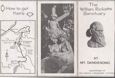
Document - LYDIA CHANCELLOR COLLECTION: THE WILLIAM RICKETTS SANCTUARY
A leaflet about the history and location of the William Ricketts Sanctuary at Mt. Dandenong. Is administered by The Forests Commission Victoria. C 1964 mapplace, public gardens, willilam ricketts sanctuary, mt. da, lydia chancellor, collection, tourism, geography, travel, map, the william ricketts sanctuary, dandenong, recreation, victoria, exploration, history, place -
 Bendigo Historical Society Inc.
Map - FRED COWIE COLLECTION: AERIAL MAPS OF HEATHCOTE/EPPALOCK, 28-9-60
... Inc. History House 11 Mackenzie Street Bendigo goldfields MAP ...Map, Heathcote C3, Aerial Survey of Victoria, Photo-map prepared by Department of Crown Lands and Survey from photographs taken in 1960.Copied photographically at the Central Plan Office. Date 28-9 60, C.P.O.Neg. No.21588.Campaspe River, Coliban River. Flower Hill. Fred Cowie,46 McIvor Rd.Bendigo (Not located 29.9.2022)Central Plan Office.map -
Bendigo Historical Society Inc.
Map - FRED COWIE COLLECTION: AERIAL MAPS OF HEATHCOTE/EPPALOCK
... Inc. History House 11 Mackenzie Street Bendigo goldfields MAP ...Map, Heathcote A3, Aerial Survey of Victoria, Photo-map prepared by Department of Crown Lands.Campaspe River , Wild Duck Creek, Knowsley, Eppalock Weir.Fred Cowie,46 McIvor Rd ,Bendigo.map -
Bendigo Historical Society Inc.
Map - FRED COWIE COLLECTION: AERIAL MAPS OF HEATHCOTE/EPPALOCK, 28-9-1960
... Inc. History House 11 Mackenzie Street Bendigo goldfields MAP ...Map, Heathcote C2, Township of Heathcote, Melbourne Road through town branching off to Bendigo & Echuca. Aerial Survey of Victoria. Photo-map prepared by Department of Crown Lands and Survey from photographs taken in 1960. Copied photographically at the Central Plan Office.Fred Cowie,46 McIvor Rd,Bgo..Central Plan Officemap -
Bendigo Historical Society Inc.
Map - FRED COWIE COLLECTION: AERIAL MAPS OF HEATHCOTE/EPPALOCK, 28-9-60
... Inc. History House 11 Mackenzie Street Bendigo goldfields MAP ...Map, Heathcote C4, Aerial Survey of Victoria,Photo-map prepared by Department of Crown Lands and Survey from photographs taken in 1960. Copied photographically at the Central Plan Office.Date 28-9-60,C.P.O.Neg.No.21590.Scale 4 inches to 1 mile. Fred Cowie,46 McIvor Rd,Bgo..Central Plan Office.map -
 Bendigo Historical Society Inc.
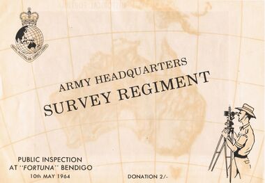
Document - ARMY HEADQUARTERS SURVEY REGIMENT, BENDIGO, 10 May, 1964
Army Headquarters Survey Regiment, Bendigo. Public Inspection at 'Fortuna', 10 May 1964. Donation 2/-. Includes photos of the Entrance Hall, Music Room and Villa. 3 army photos. In 1942 the mansion was occupied by the Australian Survey Corps and 'Fortuna' became the site of the base map production plant of the Australian Army for the remainder of the war years. During this period approximately sixteen million maps of Australian Territories and theatres of operation in the South West Pacific Area, were produced for use by the Allied Services. This function was continued as a peace time role in the post war years, and in 1951 ''Fortuna'' was purchased by the Commonwealth Government. As the largest unit of the Royal Australian Survey Corps, AHQ Survey Regiment carries out mapping in all parts of the Commonwealth and Territories including Papua and New Guinea. The Regiment is not only capable of doing its own field surveys but is responsible for the drawing and printing of map compilations from Royal Australian Survey Corps units in all States. . . . Includes map of grounds.buildings, residential, fortuna villa, army headquarters survey regiment, bendigo. public inspection at 'fortuna', 1964. photos of the entrance hall, music room and villa. mansion was occupied by australian survey corps and 'fortuna' site of the base map production plant australian army war. sixteen million maps australian territories and theatres of operation in the south west pacific area, were produced for use by the allied services. 1951 ''fortuna'' was purchased by the commonwealth government. royal australian survey corps, ahq survey regiment mapping commonwealth and territories including papua and new guinea. royal australian survey corps units in all states. map of grounds -
Bendigo Historical Society Inc.
Map - CAMPBELL COLLECTION: BENDIGO AND DISTRICT MAPS, 21-8-1972
... Inc. History House 11 Mackenzie Street Bendigo goldfields MAP ...Map. Shire of Strathfieldsaye Locality Plan. Scale 1 inch=1 mile. Drawn by M.Higgs 21-8-1972, Shire of Huntly, Shire of McIvor, City of Bendigo, Shire of Marong, Shire of Maldon, Shire of Metcalfe, Lake Eppalock, Axedale Township, Strathfieldsaye Township, Melbourne to Bendigo Railway Line, Big Hill Tunnel, Mt.Herbert 1596. (number 398 in map cupboard 1)M.Higgs 21-8-1972map, bendigo, locality plan -
Bendigo Historical Society Inc.
Map - CAMPBELL COLLECTION: BENDIGO AND DISTRICT MAPS, 21-8-1972
... Inc. History House 11 Mackenzie Street Bendigo goldfields MAP ...Map. Shire of Strathfieldsaye, Locality Plan. Scale I inch=1 mile. Shire of Huntly, Shire of McIvor, City of Bendigo, Shire of Marong, Shire of Maldon, Shire of Metcalfe. Lake Eppalock. Mileage markers on some roads. Melbourne to Bendigo Railway Line, Big Hill Tunnel, Mt.Herbert 1596.Axedale Township, Strathfieldsaye Township.M.Higgs 21-8-1972map, bendigo, locality plan -
Bendigo Historical Society Inc.
Map - CAMPBELL COLLECTION: BENDIGO AND DISTRICT MAPS, 10-5-29
... Inc. History House 11 Mackenzie Street Bendigo goldfields MAP ...Map. Mandurang, Scale 20 chains to an inch. Total area 5746 acres. Kennington, Township of Mandurang. To accompany my report of 10-5-29 R. Marshall, Forest assessor. Drawn by I.M.K. (number 399 in map cupboard 1)I.M.K.map, bendigo, allotments -
Bendigo Historical Society Inc.
Map - CAMPBELL COLLECTION: BENDIGO AND DISTRICT MAPS, 6-4-28
... Inc. History House 11 Mackenzie Street Bendigo goldfields MAP ...Map. Sedgwick, Parishes of Strathfieldsaye, Lyell, and Sedgwick. Scale 20 chains to 1 inch. Total area 5372 acres. Prepared in W.P.B. from C.L.and A. Plans by W.J.Galbraith 6-4-28. (number 400 in map cupboard 1)W.J.Galbraith.map, bendigo, agricultural lands -
Bendigo Historical Society Inc.
Map - CAMPBELL COLLECTION: BENDIGO AND DISTRICT MAPS
... Inc. History House 11 Mackenzie Street Bendigo goldfields MAP ...Map. Parishes and suburbs : North of Bendigo, Parish of Huntly, Parish of Nerring, Parish of Sandhurst, Sydney Flat, Myers Flat, Borough of Eaglehawk, Sailors Gully, Jobs Gully, Harvey Town, California Gully, Maiden Gully, Long Gully, St.Just's Point, Iron Bark.map, bendigo, parishes -
Bendigo Historical Society Inc.
Map - CAMPBELL COLLECTION: BENDIGO AND DISTRICT MAPS
... Inc. History House 11 Mackenzie Street Bendigo goldfields MAP ...Map. Sandhurst and suburbs, Parish of Sandhurst, Parish of Huntly, Parish of Nerring, Parish of Marong, Parish of Lockwood, Parish of Wellsford, Parish of Strathfieldsaye, Parish of Mandurangmap, bendigo, parishes -
Bendigo Historical Society Inc.
Map - CAMPBELL COLLECTION: BENDIGO AND DISTRICT MAPS
... Inc. History House 11 Mackenzie Street Bendigo goldfields MAP ...Map. Parish of Sandhurst, Parish of Huntly, Parish of Nerring, Parish of Marong, Parish of Lockwood, Parish of Wellsford, Parish of Strathfieldsaye, Parish of Mandurang. Scale approx 1:18,000.map, bendigo, parishes -
Bendigo Historical Society Inc.
Map - CAMPBELL COLLECTION: BENDIGO AND DISTRICT MAPS
... Inc. History House 11 Mackenzie Street Bendigo goldfields MAP ...Map. Parish of Sandhurst, Shire of Strathfieldsaye, Mandurang Parish, Junortoun.map, bendigo, city streets -
Bendigo Historical Society Inc.
Map - CAMPBELL COLLECTION: BENDIGO AND DISTRICT MAPS, 11-2-37
... Inc. History House 11 Mackenzie Street Bendigo goldfields MAP ...Map. Parish of Shelbourne, County of Bendigo. Scale 40 chains to 1 inch. Drawn and reproduced at the Department of Lands and Survey, Melbourne, Victoria. Price 2/-.11-2-37. By Authority H.J. Green, Government Printer, Melbourne.H.J. Green, Government Printermap, bendigo, agricultural lands -
Bendigo Historical Society Inc.
Map - DIGGORRA : COUNTY OF BENDIGO, 26-6-36
... Inc. History House 11 Mackenzie Street Bendigo goldfields MAP ...Map. Parish of Diggorra, County of Bendigo, Parish of Ballendella, Parish of Pannoobamawm, Pannoomilloo, Rochester West, Warragamba, Minto, Egerton, Elmore, Northern Railway to Echuca, Elmore and Cohuna Railway, Township of Elmore. By authority H.J. Green, Govt. Printer. Photo-Lithographed at the Deptartment of Lands and Survey, Melbourne. 26-5-36. (number 58 in map cupboard 1)H.J. Green, Govt. Printer.map, bendigo, diggorra -
Bendigo Historical Society Inc.
Map - DIGGORRA PARISH : COUNTY OF BENDIGO, 6-9-21
... Inc. History House 11 Mackenzie Street Bendigo goldfields MAP ...Map. Parish of Diggorra, County of Bendigo, Parish of Bamawm, Rochester West, Pannoomilloo, Warragamba, Minto, Egerton, Elmore, Northern Railway, Parish of Ballendella. Elmore /Cohuna Railway. Photo-Lithographed at the Department of Lands and Survey, Melbourne by W.J. Butson, 6-9-21, Price 1/-.. By authority A.J. Mullett, Government Printer. (number 57 in map cupboard 1)A.J. Mullett, Government Printer.map, bendigo, diggorra -
 Bendigo Historical Society Inc.
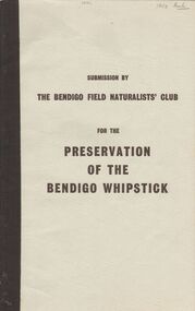
Book - 'PRESERVATION OF THE BENDIGO WHIPSTICK'' (SUBMISSION)
... Naturalists Club. Shire of Lodden Map. Bendigo Field Naturalist Club ...Preservation of the Bendigo Whipstick'' (Third Edition of a Submission by the Bendigo Field Naturalists' Club 1971). An application to the Forests Commission for two areas to be declared Forest Parks under the Appropriate Act. (The two areas are indicated on a map submitted under separate cover). Supportive material includes listings of various categories e.g. flora i.e Whipstick native plants; Additional Plant Species; Species of Birds; Mammals of the Whipstick; historical summary; Whipstick nuggets; Bendigo Whipstick 'Statistics'. .Bendigo Field Naturalist Club.government, state, whipstick, bendigo whipstick, the bendigo field naturalists club. shire of lodden map. -
Bendigo Historical Society Inc.
Map - HARCOURT, December 1951
... Inc. History House 11 Mackenzie Street Bendigo goldfields MAP ...Harcourt, County of Bendigo, Walmer, Castlemaine, Sutton Grange. Mt.Alexander Trig. Station, Barkers Creek, Faraday, Calder Highway, Northern Railway. By Authority J.J.Gourley, Government Printer, Melbourne,Drawn and Reproduced at the Dept. of Lands and Survey, Melbourne, Victoria. December 1951. Price 5/-per sheet. (number 35 in map cupboard 1)J.J.Gourley, Government Printer, Melbourne.map, bendigo, harcourt -
 Bendigo Historical Society Inc.
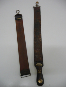
Accessory - RAZOR STROPS
Container (round flat box) of pink-coloured ('Peche') 'Cashmere Bouquet' Face Powder . Top of box ha Two razor strops. 'Gem' brand with attached metal clasp (opening clip); 'Malwa' brand with fixed clip; loose opening clip (from Malwa strop?). Shaped leather handle (detached) with the following in gold embossing - 'Specially Prepared'; '16' with surrounding wreath; map of Australia (with wreath). s product name and flower motif; back of box has manufacturer's details (Colgate Palmolive; Made in Australia etc.personal effects, shaving, razor strop -
 Bendigo Historical Society Inc.
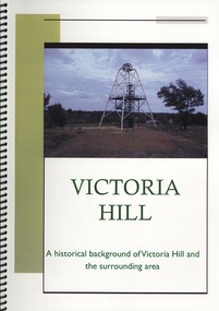
Book - VICTORIA HILL, A HISTORICAL BACKGROUND OF VICTORIA HILL AND THE SURROUNDING AREA, 2011
Victoria Hill a historical background of Victoria Hill and the surrounding area. Original article by Albert Richardson 1971 and revised and edited in 2012 by Philip Wilkin. Contains 26 pages with colour and black & white photographs and a map. Inside front cover is a 'Bendigo Miner' History Lives article by Jim Evans, dated 10 May 2012.Albert Richardson & Phillip Wilkinbendigo, mining, victoria hill -
 Bendigo Historical Society Inc.
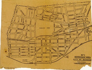
Newspaper - BENDIGO SEWARAGE AREA NEWSPAPER CUTTING, 1921
... showing map of the No 1 Sewerage Area City of Bendigo. 1921 ...Newspaper cutting showing map of the No 1 Sewerage Area City of Bendigo. 1921bendigo, planning, sewerage, bendigo sewerage