Showing 10629 items
matching maps
-
 Victorian Aboriginal Corporation for Languages
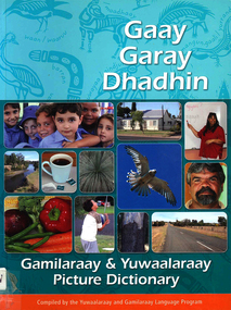
Book, Gaay garay dhadhin : Gamilaraay &? Yuwaalaraay picture dictionary, 2006
A wonderful source of reference for teachers and students alike. The seventh in this innovative series.Colour photographs, b&w illustrations, maps, word listsgamilaraay, yuwaalaraay -
 Victorian Aboriginal Corporation for Languages
Book, Jon Altman et al, Aboriginal people of the Northern Territory, 2004
Looks at the culture and history of some of the Northern Territory Aboriginal groups.colour photographs, b&w photographs, illustrations, maps, tables -
 Victorian Aboriginal Corporation for Languages
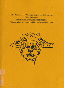
Book, Ian D Clark, The journals of George Augustus Robinson, Chief Protector, Port Phillip Aboriginal Protectorate : volume one : 1 January 1839 - 30 September 1840, 1998
Transcription of G. A. Robinson?s journals for the period 01/01/1839 - 30/09/1840. Includes some reproductions of sketches, and some wordlists of Aboriginal languages and Aboriginal personal and place names.maps, document reproductions, b&w illustrations, word listsgeorge augustus robinson, port phillip, colonisation -
 Victorian Aboriginal Corporation for Languages
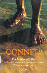
Book, Eve Mumewa D Fesl, Conned!, 1993
Language is power. It is used to describe and direct events fictional and true. This book describes how historians have manufactured a flattering Australian race relations history. Conned! challenges established perceptions of Indigenous Australians.maps, b&w illustrations, b&w photographs, chartsaboriginal languages association, atsic, education, electoral system, moravian -
 Victorian Aboriginal Corporation for Languages
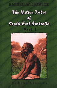
Book, A W Howitt, The native tribes of South-East Australia : part 1, 2003
Alfred William Howitt 1830-1908 was a pioneer anthropologist. ?The Native Tribes of South-East Australia? is not only a great classic anthropological work, it contains an enormous wealth of material of interest to anyone interested in Australian history, particularly the people of Koorie descent. His work has been presented here in total as originally produced.maps, b&w illustrations, b&w photographs, tablesdieri, wonkanguru, yuin, wonkamala, kulin, kurnai, wiradjuri, kamilaroi, wotjobaluk, wurrunjerri, wimbaio, yaurorka, urabunna, yantruwunta -
 Victorian Aboriginal Corporation for Languages
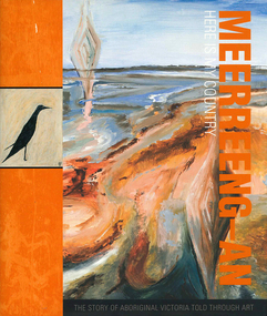
Book, Chris Keeler, Meerreeng-an here is my country : the story of Aboriginal Victoria told through art, 2010
maps, b&w illustrations, colour illustrations, colour photographsbangerang, bidawal, boonwurrung, dharwurd wurrung, dja dja wurrung, djab wurrung, gunnai kurnai, jardwadjali, jadawadjali, keerray woorroong, latji latji, peek wurrong, taungurung, wathaurung, wergaia, wotjobaluk, wurundjeri, yorta yorta -
 Victorian Aboriginal Corporation for Languages
Book, Nicholas Thieberger, Paper and talk : a manual for reconstituting materials in Australian Indigenous languages from historical sources, 1995
Collection of essays about language and language sources.Sheet music, b&w photographs, maps, word listslinguistics, murri, endangered languages -
Victorian Aboriginal Corporation for Languages
Book, Jon Altman et al, Aboriginal people of the Northern Territory, 1998
Looks at the culture and history of some of the Northern Territory Aboriginal groups.colour photographs, b&w photographs, illustrations, maps, tables -
Victorian Aboriginal Corporation for Languages
Book, Jon Altman et al, Aboriginal people of the Northern Territory, 1992
Looks at the culture and history of some of the Northern Territory Aboriginal groups.colour photographs, b&w photographs, illustrations, maps, tables -
Victorian Aboriginal Corporation for Languages
Conference proceedings, Jon Reyhner, Teaching Indigenous languages, 2012
Teaching Indigenous Languages is a compilation of papers presented at the Fourth Annual Stabilizing Indigenous Languages Symposium sponsored by Northern Arizona University's Center for Excellence in Education and Dept. of Modern Languages on May 1-3, 1997 at the University's du Bois Conference Center in Flagstaff, Arizonamaps, b&w illustrations, b&w photographs, gamesmaori, apache, arapaho, navajo, cherokee, language and literacy development, bilingual education, indigenous language teaching, language education and technology, language renewal -
Victorian Aboriginal Corporation for Languages
Conference proceedings, Nicholas Ostler, Endangered languages and literacy : proceedings of the Fourth FEL Conference, University of North Carolina, Charlotte, 21-24 September 2000, 2000
Main headings: Opening the book; Literacy from within; Choosing an orthography; Literacy & Dialect diversity; Promoting literacy; Cautionary notesmaps, b&w photographs, b&w illustrations, tablesendangered languages, language revival, orthography, literacy -
Victorian Aboriginal Corporation for Languages
Conference proceedings, Tjeerd de Graaf, Endangered languages and language learning : proceedings of the FEL XII, 24-27 September 2008 Fryske Akademy, It Aljemint, Ljouwert/?Leeuwarden, The Netherlands, 2008
Learning the details, Different approaches in the classroom, School contexts, Innovative methods, Multilingualism and diaspora, Policy overviewmaps, b&w photographs, colour photographs, tables, graphsmultilingualism, education, bilingualism, language endangerment, language transmission -
Victorian Aboriginal Corporation for Languages
Conference proceedings, Maya Khemlani David, Working together for endangered languages : research challenges and social impacts : proceedings of the XIth FEL Conference, University of Malaya, Kuala Lumpur, Malaysia, 26-28 October 2007, 2007
maps, b&w photographs, colour photographs, illustrations, graphsendangered languages, language revival, education, language research -
Victorian Aboriginal Corporation for Languages
Conference proceedings, Mary Jane Norris, Endangered languages beyond boundaries : community connections, collaborative approaches and cross-disciplinary research =? Langues en pe?ril au-dela? des frontie?res : connexions communautaires, approches collaboratives, et rechecrche interdisciplinaire : proceedings of the 17th FEL Conference Carleton University, Ottawa, Ontario Canada 1-4 October 2013, 2013
Session 1: Collaborations with language and cultural organizations, and governments Session 2: Collaborations with universities, researchers, institutes and schools Session 3: Strategies/issues across language, culture, geography, place and generations I: standardization and dialects Session 4: Strategies issues across language, culture, geography, place and generations II: Minority languages, regions and rural/urban areas Session 6: Language and culture connections: Health, well-being, and educational outcomes Session 7: Strategies/issues across language, culture, geography, place and generations III: Generations and families Session 8: Language assessment, documentation and diversity: Indicators of vitality, endangerment and the implications of data collection Session 5: Poster sessions I: Hard copy: Community connections, collaborative approaches, cross-disciplinary research Session 5: Poster session II: Electronic: Collaborative approaches with information and computer technologiesmaps, b&w photographs, colour photographs, illustrations, graphscollaboration, community involvement, cross disciplinary research -
 Victorian Aboriginal Corporation for Languages
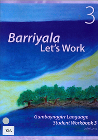
Book, Julie Long, Barriyala - let's work : Gumbaynggirr language student workbook 3, 2007
Workbook with songs, games and activities for primary school children.Colour illustrations, b&w illustrations, word lists, mapsgumbaynggirr, nambucca heads, junga-ngarraangala gumbaynggirr, muurrbay, primary school, workbook -
 Victorian Aboriginal Corporation for Languages
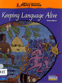
Book, Trish Albert, Keeping language alive, 2008
Maps, colour photographs, colour illustrations, sheet music, gamesguugu yimithirr, wiradjuri, torres strait creole -
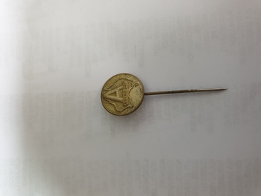 Clayton RSL Sub Branch
Button, Anzac pin
early metal WW1 Anzac Day pinbrass looking pin with round head and long pin. HYAMS, Frederick collection"A" embossed over a map of Australia with Anzac Day stamped under the "A" -
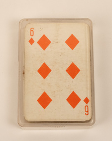 Stanley Athenaeum & Public Room
Leisure object - Euchre cards
757 Deer brand playing cards New Zealand Playing cards, emblem and map of New Zealand -
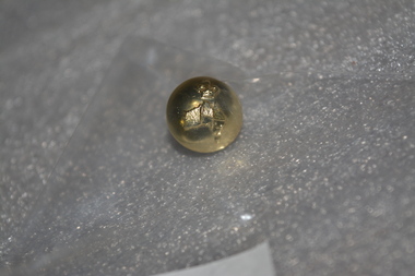 Wangaratta RSL Sub Branch
Button
Small gold coloured Australian Military Forces button.On front: Map of Australia with a crown on top. On back: Stokes Melbaustralian military forces, button -
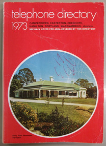 Warrnambool and District Historical Society Inc.
Book, Telephone Directory 1973, 1973
The numbers listed in this directory are under the heading of districts and the listings within the districts are again sub-listed under the various towns. So in the Warrnambool district there are listings under Winslow, Panmure, Orford, Port Fairy. Wangoom etc.This directory is of some importance as the names and addresses of those with telephones in 1973 in the local areas are listed. Most of the listings of the smaller towns give the names of the homes and properties. So this is a very useful tool for research purposes.This is a soft cover booklet with a red cover and an oval-shaped insert colour photograph of Stony Point Homestead, Darlington, on the front cover and a map of the telephone area on the back cover. Front cover – Telephone Directory 1973, Camperdown, Casterton, Edenhope, Hamilton, Portland, Warrnambool districts. See back cover for area covered by this directory Spine – Camperdown, Casterton, Edenhope, Hamilton, Portland, Warrnambool districts. See the pink pages for business & trade listings. VI- 1973 Back Cover – Country directory areas. The area covered by this Directory is the coloured portion of this map. See the pink pages for business and trade listings. warrnambool, warrnambool telephone directory 1973 -
Bendigo Historical Society Inc.
Map - BENDIGO, issued 1st January 1906
Map: Sketch map of Bendigo, including Eaglehawk and the Parish of Sandhurst. Issued by the Fire Underwriters Association of Victoria. Revised copy (number 317 in map cupboard 1)map, bendigo, city streets, map of bendigo, fire underwriters association of victoria -
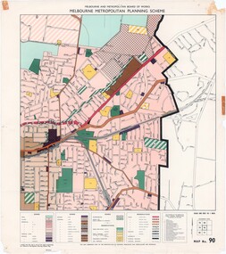 Ringwood and District Historical Society
Map - Melbourne Metropolitan Planning Scheme, Municipality of Ringwood area - circa 1970
Colour-coded map marking proposed and existing business, industrial, transportation, public reservation, etc. planning zones within the City of Ringwood. Includes (undated) certification that this map is one of the maps constituting the Melbourne Metropolitan Planning Scheme Map.Scale: 800 feet to 1 inch. -
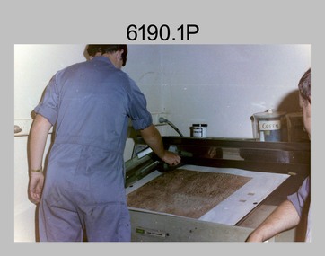 Bendigo Military Museum
Photograph - Lithographic Technicians preparing a Cromalin map proof at the Army Survey Regiment, Fortuna Villa Bendigo
These six photographs were most likely taken in the 1990s in Lithographic Squadron at the Army Survey Regiment, Fortuna, Bendigo. There is no annotation describing the date or personnel in the photographs. Cromalin proofing was a laminate and dry powder proofing system introduced in 1978. The system allowed the production of true to colour proofs, mainly for the proofing of orthophoto maps and process printed 1:250,000 JOG that used positive printing plates. It was upgraded in 1986. The pre-press proof was a cost-effective way of producing a one-off visual copy of the map or chart product. It enabled cartographers to perform a quality inspection and correct any faults before publication. The pre-press proof was deemed authoritative before its release to Print Troop for bulk printing and distribution.This is a set of six photographs of lithographic technicians preparing Cromalin map proofs at the Army Survey Regiment, Bendigo c1990s. The photographs were on 35mm negative film and were scanned at 96 dpi. They are part of the Army Survey Regiment’s Collection. .1) to .6) - Photo, colour, c1990s, printer technician SPR Shona Hastie, Lithographic Squadron. .1P to .6P – no annotationroyal australian survey corps, rasvy, army survey regiment, army svy regt, fortuna, asr, litho -
University of Melbourne, Burnley Campus Archives
Map, Melbourne and Metropolitan Planning Scheme, c. 1978
Maps showing Zones and Reservations in the Merri Creek area of Melbourne, prepared by the Drafting Department, Planning Branch, MMBW. (1) Map No 36, coloured. (2) Map No 37, coloured. (3) Map No 38, not coloured. (4) Map No 46. May have been used in planning the Native Garden Woodland Area. merri creek, management plan -
Bendigo Historical Society Inc.
Document - MARKS COLLECTION: MAP OF EAGLEHAWK/LONG GULLY AREA
Map of Eaglehawk and Long Gully area. Maps shows allotments and areas. Map is split down centre (torn ?) and in two pieces. Map was located in Fortuna papers, potentially belonged to G. Lansell. Section of map has been neatly cut out - area near Mt Korong Road and Victoria Hill. -
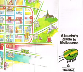 Melbourne Tram Museum
Pamphlet, The Met, "A tourist's guide to Melbourne", mid 1980's
... Maps ...Pamphlet, 14 fold printed in full colour on semi gloss paper, both sides. Gives a cartoon style map of the CBD, Melbourne suburbs and outer Melbourne, giving a list of places of interest and transport routes. Shows the vintage tram service along Batman Ave, Puffing Billy, Wattle Park, various precincts, shopping centres. Published by The Met, Metropolitan Transit and has the buzz logo on the front. Mid 1980's. Two copies heldtrams, tramways, maps, tourism, melbourne, wattle park, the met -
 Kew Historical Society Inc
Map, Robert Russell, Map Shewing the Site of Melbourne and the Position of the Huts & Buildings Previous to the Foundation of the Township by Sir Richard Bourke in 1837
Map shows the first layout of Melbourne by Government surveyor Robert Russell, who accompanied Governor Richard Bourke in 1837. The surveyed blocks extend from present-day Flinders Street to Lonsdale Street, and Spring Street to Spencer Street, with extensive vacant land west to a salt lake (afterwards Batman's Swamp, later drained), north beyond Flagstaff Hill and south towards South Melbourne. Vegetation coverage is indicated, and tracks and existing buildings and cultivated land are shown.Printed map was created by Day & Haghe, Lithographers to the Queen, sometime after 1838, when the company received its Royal appointment. Copies of the 1837 map exist in several major map collections in Australia; most are uncoloured. This particular map is the earliest in the Kew Historical Society's map collection. It is a nationally significant artefact. Black and white lithographed map hand-coloured in blue and yellow gouache of the town of Melbourne in 1837. In contrast to the original lithograph, the river and the township blocks are coloured blue and yellow. A similar, partly coloured copy is in the collection of the University of Melbourne.maps - melbourne - 1830s, governor sir richard bourke, robert russell - surveyor, cartography -
Whitehorse Historical Society Inc.
Document, Villa Residence, 11/12/1937 12:00:00 AM
Auction brochure for 'beautiful modern brick villa residence', with 4 1/4 acres of land, Mitcham Road Mitcham, Saturday December 11 1937.Auction brochure for 'beautiful modern brick villa residence', with 4 1/4 acres of land, Mitcham Road Mitcham, Saturday December 11 1937, under instructions from the executors of the estate of the late E. E. Walker. Frontages to Mitcham Road, Delhi Street and Agra Street. Auctioneers: Baillieu Allard in conjunction with Drake & Co. Original copy framed, located in Map Drawer.Auction brochure for 'beautiful modern brick villa residence', with 4 1/4 acres of land, Mitcham Road Mitcham, Saturday December 11 1937.walker, edgar edwardes, walker estate, mitcham road, mitcham, delhi street mitcham, agra street, mitcham, drake & co., baillieu allard pty ltd -
 Melbourne Tram Museum
Document - Report, Melbourne & Metropolitan Tramways Board (MMTB), "Passenger movements by public transport for the Central city Business area based on results of the 1964 Melbourne Metropolitan Transportation Study, Nov. 1965
... Maps ...Report - Foolscap landscape format, red tape binding - approx. 80 pages with notes, diagrams, charts, maps showing passenger traffic for parts of each route, including Railway Stations, passenger flows, titled "Passenger movements by public transport for the Central city Business area based on results of the 1964 Melbourne Metropolitan Transportation Study.In top right hand corner "Lees" in inktrams, tramways, mmtb, tramways, melbourne, surveys, passengers, railways, maps -
 Bendigo Military Museum
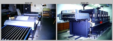
Photograph - Print Troop Equipment, Lithographic Squadron – Army Survey Regiment, Fortuna, Bendigo, c1990s
This is a set of 25 photograph of Print Troop Equipment in Lithographic Squadron, Army Survey Regiment at Fortuna, Bendigo, 1990. Photo .1P features the new Howson Algraphy Autoneg printing plate processor. It improved quality control and efficiency and allowed the conversion of printing plates for positive or negative use. The Heidelberg Speedmaster 102 shown in photos .2P to .4P was a computer-controlled five colour lithographic offset printing press. It provided the Royal Australian Survey Corps a vastly improved printing capability, as the five colours for a standard topographic map was printed in a single pass. The print room housing the Speedmaster printing press was named Wayzgoose Hall after a medieval printing house festival. Wayzgoose Hall and the Speedmaster printing capability was commissioned by the Commander of the 3rd Military District BRIG P. Davies AM, ADC on Wednesday 27th June 1990. This occasion is covered in more detail in page 145 of Valerie Lovejoy’s book 'Mapmakers of Fortuna – A history of the Army Survey Regiment’ ISBN: 0-646-42120-4. For additional photos, refer to item 6062.4P for more photos of the Heidelberg Speedmaster printing press. The Print Room’s Map Assessment and Colour Evaluation Stations in photos .5P to .12P provided the Printer Technician suitable viewing environments to perform quality assessments of map samples. See item 6151.34P for more information and photos of technicians using the equipment. The Print Room’s Map Handling Station in photo .15P to .20P provided ergonomic benefits to the Printer Technician and improved despatching productivity. See Item 6070.9P for more information and photos. The Wohlenberg MCS-2 guillotine seen in photos .21P & .22P was a heavy-duty guillotine integrated component of the Map Handling Station, to trim bulk printed map stock. See item 6069.6P for more information and photos of earlier types of guillotine equipment. This is a set of 25 photograph of Print Troop Equipment in Lithographic Squadron, Army Survey Regiment at Fortuna, Bendigo, 1990. The photographs are on 35mm colour slides and were scanned at 96 dpi. They are part of the Army Survey Regiment’s Collection. .1) - Photo, colour, c1990s, Howson Algraphy Autoneg printing plate processor .2) to .4) - Photo, colour, 1990. Heidelberg Speedmaster 102 computer-controlled five colour lithographic offset printing press .3) to .10) - Photo, colour, c1990s, Heidelberg Speedmaster CPC 1-04 control unit. .11) to .12) - Photo, colour, c1990s, Map Colour Evaluation Work Station. .13) to .14) - Photo, colour, c1990s, Linear printing plate registration punch. .15) to .20) - Photo, colour, c1990s, Print Room’s Map Handling Station. .21) to .22) - Photo, colour, c1990s, Wohlenberg MCS-2 guillotine. .23) - Photo, colour, c1990s, Print Room Power supply equipment. .24) to .25P - Photo, colour, c1990s, Print Room Crown Fork Lift..1P to .25P - There are no annotations stored with the 35mm slides.royal australian survey corps, rasvy, army survey regiment, army svy regt, fortuna, asr, printing, litho