Showing 14962 items
matching the white house
-
 Glenelg Shire Council Cultural Collection
Sculpture, URSULA DUTKIEWICZ, Vida Goldstein, c. 2007
I am a Melbourne based ceramic artist creating sculpture, murals, community art projects, commissioned works and residencies. I am a passionate facilitator of creativity and have extensive experience working, teaching and running workshops with in communities, schools and with people of all ages and abilities. My involvement with so many varied and interesting projects constantly informs my work and leads me to develop in new and exciting directions. The Arts of Suff-Rage (exhibition statement) In 2008 I joined forces with fellow artist Fern Smith in creating The Art of Suff-Rage traveling art installation. The project sees us roving Victoria dressed as suffragist giving out the latest edition of our newspaper. The installation celebrates the Centenary of Women’s Suffrage in Victoria and I have created one hundred ceramic suffragist sculptures each around 30cm in height. Fern has painted ten commemorative banners to honor the legacy of women campaigning for equality. Gasworks Arts Park has auspice the project and we received funding from the Department of Planning and Community Development Grants Program-Centenary of Women’s Suffrage. Thank you to everyone who has helped to get the project up and running. Fern and I ventured to Portland recently with The Art of Suff-Rage traveling art installation for an exhibition of our work. The exhibition consists of the entire body of work that we produced last year for the centenary celebrations of Victorian Women Vote 1908 – 2008. As Portland was the birth place of Vida Goldstein it was fantastic we had this opportunity to explore more of her adventures.Ceramic sculpture of Vida Goldstein, long black skirt, white blouse purple and white patterned jacket, hat with blue brim and purple and white patterned crown. She is holding posters in support of votes for women.Front: Inside base: "Ursula Dutkiewicz Vida 2007' - black textasculpture, vida goldstein, suffrage, womens rights victorian women -
 Glenelg Shire Council Cultural Collection
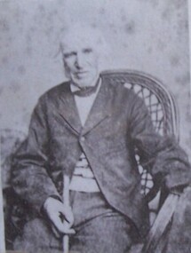
Print, Joshua Black, n.d
Black and white laminated laser copy. Joshua Black is sitting in a cane chair-holding walking stick. Wearing a one button coat. Card on front - Joshua Black.Front: W.L. Blac, photo, Portland. No. Copies may be had by sending number.joshua black, portland -
 Glenelg Shire Council Cultural Collection
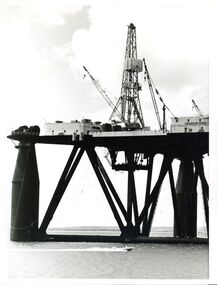
Photograph - Photograph - oil rig, Con Kroker, 1966
Con Kroker Private CollectionBlack & white photograph of a SEDCO Oil Rig in Portland Harbour. A speed boat in foreground.con kroker, kroker, photography -
 Glenelg Shire Council Cultural Collection
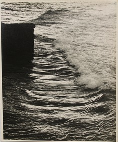
Photograph, Seascape, n.d
Con Kroker Private CollectionBlack & white photo of the sea, with a squarish rock formation on left. Wave has 'broken' & foam almost to rock.Back: LAT 5D - pencil, very faintcon kroker, kroker, photography, seascape -
 Glenelg Shire Council Cultural Collection
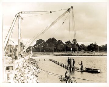
Photograph, Fisherman's Breakwater, n.d
Con Kroker CollectionBlack & white photograph showing construction at Fisherman's Breakwatercon kroker, kroker, photography, fishermans breakwater -
 Greensborough Historical Society
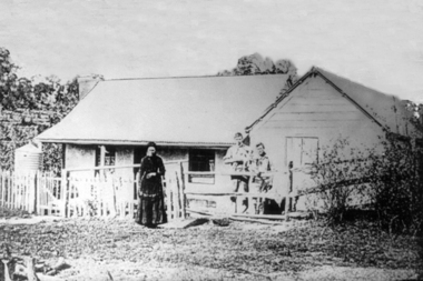
Photograph - Digital image, Mary Poulter, 1888c
Mary Poulter and sons in Greensborough. The boys could be William (b1865) and Arthur (b1867). Mary appears to be in mourning, her husband William died in 1888. William Poulter and his wife Mary arrived in Victoria in 1849 and settled in Greensborough in 1853. Descendants of the family still live in the area. The house was known as Bonnie Vale and located roughly in the middle of what is now Poulter Reserve.Greensborough pioneer family Digital copy of black and white photograph.mary poulter, poulter family, bonnie vale, poulter reserve -
![Sketch - Digital image, William Poulter's Bonnie Vale [sketch], 1925c](/media/collectors/4f729f5697f83e03086015b8/items/54d0485a2162f10e70db9490/item-media/54d0489e2162f10e70db9ed3/item-fit-380x285.jpg) Greensborough Historical Society
Greensborough Historical SocietySketch - Digital image, William Poulter's Bonnie Vale [sketch], 1925c
Copy of sketch of William Poulter's property "Bonnie Vale". William Poulter and his wife Mary arrived in Victoria in 1849 and settled in Greensborough in 1853, constructing "Bonnie Vale" soon after their arrival. The old house was completely destroyed by fire circa 1960. Bonnie Vale, if existent in modern times would have been found in south eastern centre of Poulter Reserve, over the Plenty River is the house property known as 'Blackjack' on 59 Hume Street.Greensborough pioneer family Digital copy of black and white sketch. -
 Greensborough Historical Society
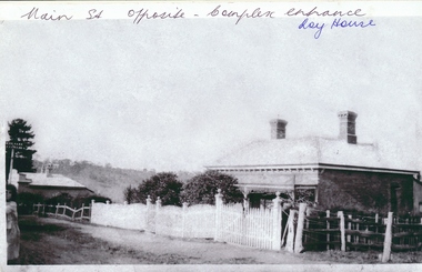
Photograph - Digital image, Roy house 1, 1930c
... and white photograph. Roy house 1 Photograph - Digital image ...Photograph of the Roy house in Main Street Greensborough. This house was situated opposite the present entrance to Greensborough Plaza, but has been demolished. An early view of the residential area which is now a commercial strip.Digital copy of black and white photograph.Written on front of photograph: "Main St. opposite complex entrance - Roy house"roy family -
 Greensborough Historical Society
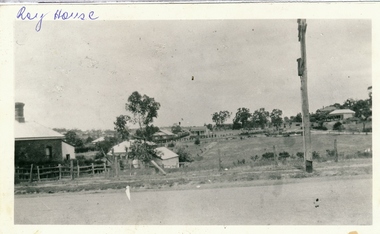
Photograph - Digital image, Roy house 2, 1930c
... of photograph: "Roy house" Digital copy of black and white photograph ...Photograph of the Roy house in Main Street Greensborough. This house was situated opposite the present entrance to Greensborough Plaza, but has been demolished. An early view of the residential area which is now a commercial strip.Digital copy of black and white photograph.Written on front of photograph: "Roy house"roy family, main street greensborough -
 Greensborough Historical Society
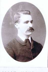
Photograph - Digital Image, Charles Partington Junior, 1898c
Photograph of Charles Partington Junior. [Verified by Faye Partington who built the house at 25 Haile Street that later had a room used for the Police Station]Charles Partington and family came to Melbourne in the 1840s and moved to Greensborough where they farmed along the Plenty River. Descendants still live in Greensborough.Digital copy of black and white studio photograph.partington family -
 Greensborough Historical Society
Photograph - Digital image, Marsh house 1973, 1973_
... . (Copy made 31/10/2011) This is a significant house ...Richard Marsh's family home on the corner of Hailes and Church Street Greensborough, taken in 1973. (Copy made 31/10/2011)This is a significant house in Greensborough, still standing today.Digital copy of black and white photograph.richard marsh, marsh house, hailes street greensborough -
 Greensborough Historical Society
Photograph - Digital image, Marble Hall, 1930-1940
Photograph of "Marble Hall", Greensborough. The Marble Hotel, Greensborough was located at the corner of Main Street and Para Road. The first licensed hotel in Greensborough and one of the earliest brick buildings was built by James Chapman in the early 1850s as a hotel and lodging house to cater for wood carters and those trying their luck at the gold fields but served many functions over the years including post office, general store, public hall, butchers, bakers, surgery, private dwelling and baby health care centre. It got its name due to its white washed exterior. This photo is from the Lorraine Coates Collection.Photograph of early Greensborough building, now demolished.Digital copy of black and white photograph.marble hotel greensborough, james chapman, marble hall greensborough -
![Photograph - Digital image, Greensborough Railway Station [2], 1930-1940](/media/collectors/4f729f5697f83e03086015b8/items/54435c822162f10ea4a1fd2b/item-media/54435ca72162f10ea4a1fe4b/item-fit-380x285.jpg) Greensborough Historical Society
Greensborough Historical SocietyPhotograph - Digital image, Greensborough Railway Station [2], 1930-1940
Photograph of Greensborough Railway Station, early 20th century, showing train and group of young people on platform. A car parked outside the Roy House on Main Street Greensborough [opposite the future entrance to the Greensborough Plaza] This photo is from the Lorraine Coates Collection.An early photograph of Greensborough Station.Digital copy of black and white photograph.greensborough station -
 Greensborough Historical Society
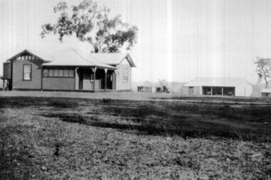
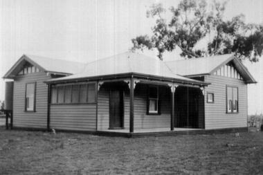
Photograph - Digital Image, Saxam exterior, 1896c
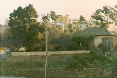
'Saxam' was the home of the Kaye family (1886-1888) then William Santon, a former councillor and Mayor of Heidelberg. Saxam Homestead is a distinctive and substantial timber homestead built in the late 1880s as one of the notable rural properties in the St Helena area. In 2014 the house still stands but is in poor condition with most interior features removed. Digital copy of black and white photograph. saxam, santon family, william santon, kaye family -
 Greensborough Historical Society
Photograph - Digital image, Saxam interior, 1896_
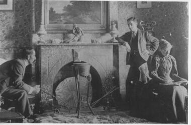
'Saxam' was the home of the Kaye family (1886-1888) then William Santon, a former councillor and Mayor of Heidelberg. Saxam Homestead is a distinctive and substantial timber homestead built in the late 1880s as one of the notable rural properties in the St Helena area. [Photo G. Studley]. Seated are Mr and Mrs Kaye, standing William Santon who was a local footballer, councillor and later Mayor of Heidelberg. In 2014 the house still stands but is in poor condition with most interior features such as this fireplace removed. Digital copy of black and white photograph.saxam, william santon, santon family -
 Greensborough Historical Society
Photograph - Digital Image, Diamond Valley Hospital, 1942c
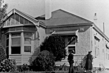
The Diamond Valley Community Hospital was established in 1942 in Grimshaw Street Greensborough. Prior to the hospital, health services in the area had been limited. The Hospital closed in 2000. This photograph is of the first hospital on the Diamond Valley Hospital site. This area on Grimshaw Street now houses many medical services in what was once the Diamond Valley Community Hospital.Digital copy of black and white photograph.diamond valley community hospital, genista house -
 Greensborough Historical Society
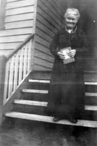
Photograph - Digital image, Mrs Mac Loused, 1935, 1935_
Part of a collection of photographs owned by Dorris McLaughlin who was born in Greensborough, in 1899 to John McLaughlin and Rosalie Ellen Whatmough. The collection contains photographs of friends and relatives from the Greensborough and Eltham areas. Photograph of woman on steps of house.Digital copy of black and white photograph.dorris mclaughlin -
 Greensborough Historical Society
Photograph - Digital image, Eltham, 1933, 1933_
Part of a collection of photographs owned by Dorris McLaughlin who was born in Greensborough; in 1899 to John McLaughlin and Rosalie Ellen Whatmough. The collection contains photographs of friends and relatives from the Greensborough and Eltham areas. This photograph shows a house and outbuildings in Eltham.Digital copy of black and white photograph.dorris mclaughlin, eltham -
 Greensborough Historical Society
Photograph - Digital image, Eltham, 1933, 1933_
Part of a collection of photographs owned by Dorris McLaughlin who was born in Greensborough, in 1899 to John McLaughlin and Rosalie Ellen Whatmough. The collection contains photographs of friends and relatives from the Greensborough and Eltham areas. This photograph shows a farm house in Eltham.Digital copy of black and white photograph.dorris mclaughlin, eltham -
 Greensborough Historical Society
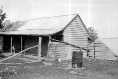
Photograph - Digital image, Old house, Eltham, 1933, 1933_
... mclaughlin eltham Digital copy of black and white photograph. Old ...Part of a collection of photographs owned by Dorris McLaughlin who was born in Greensborough, in 1899 to John McLaughlin and Rosalie Ellen Whatmough. The collection contains photographs of friends and relatives from the Greensborough and Eltham areas. This photograph shows the old farmhouse at John McLaughlin's Eltham property.Digital copy of black and white photograph.dorris mclaughlin, john mclaughlin, eltham -
 Greensborough Historical Society
Photograph - Digital image, John McLaughlin's Eltham farm, 1934, 1934_
Part of a collection of photographs owned by Dorris McLaughlin who was born in Greensborough, in 1899 to John McLaughlin and Rosalie Ellen Whatmough. The collection contains photographs of friends and relatives from the Greensborough and Eltham areas. This photograph shows a view of John McLaughlin's Eltham farm house. The McLaughlin family never lived in this house.Digital copy of black and white photograph.dorris mclaughlin, john mclaughlin -
![Photograph - Digital image, Loyola 1 [Chapel interior] 1934, 1934_](/media/collectors/4f729f5697f83e03086015b8/items/54a8ff672162f10f003491e0/item-media/54a8ffa02162f10f00349877/item-fit-380x285.jpg) Greensborough Historical Society
Greensborough Historical SocietyPhotograph - Digital image, Loyola 1 [Chapel interior] 1934, 1934_
Chapel Interior 1934. A collection of photographs of the Jesuit Seminary in Grimshaw Street Watsonia. Opened in 1934, this was a house of formation and study for the Society of Jesus. Loyola College (established 1980), now occupies the site and purchased the original building in 2002.Copies of official photographs taken to record the opening of Loyola in 1934.Digital copy of black and white photograph.loyola seminary watsonia -
![Photograph - Digital image, Loyola 3 [exterior main building] 1934, 1934_](/media/collectors/4f729f5697f83e03086015b8/items/54a900dc2162f10f0034ab7a/item-media/54a9011b2162f10f0034b112/item-fit-380x285.jpg) Greensborough Historical Society
Greensborough Historical SocietyPhotograph - Digital image, Loyola 3 [exterior main building] 1934, 1934_
Exterior Main Building. A collection of photographs of the Jesuit Seminary in Grimshaw Street Watsonia. Opened in 1934, this was a house of formation and study for the Society of Jesus. Loyola College (established 1980), now occupies the site and purchased the original building in 2002.Copies of official photographs taken to record the opening of Loyola in 1934.Digital copy of black and white photograph.loyola seminary watsonia -
![Photograph - Digital image, Loyola 4 [Dining Hall] 1934, 1934_](/media/collectors/4f729f5697f83e03086015b8/items/54a902542162f10f0034ca29/item-media/54a9027e2162f10f0034ce3d/item-fit-380x285.jpg) Greensborough Historical Society
Greensborough Historical SocietyPhotograph - Digital image, Loyola 4 [Dining Hall] 1934, 1934_
Dining Hall 1934. Part of a collection of photographs of the Jesuit Seminary in Grimshaw Street Watsonia. Opened in 1934, this was a house of formation and study for the Society of Jesus. Loyola College (established 1980), now occupies the site and purchased the original building in 2002.Copies of official photographs taken to record the opening of Loyola in 1934.Digital copy of black and white photograph.loyola seminary watsonia -
![Photograph - Digital image, Loyola 5 [Driveway] 1934, 1934_](/media/collectors/4f729f5697f83e03086015b8/items/54b9e5d62162f10918707b9a/item-media/54b9e67b2162f10918708382/item-fit-380x285.jpg) Greensborough Historical Society
Greensborough Historical SocietyPhotograph - Digital image, Loyola 5 [Driveway] 1934, 1934_
Part of a collection of photographs of the Jesuit Seminary in Grimshaw Street Watsonia. Opened in 1934, this was a house of formation and study for the Society of Jesus. Loyola College (established 1980), now occupies the site and purchased the original building in 2002.Digital copy of black and white photograph.loyola seminary watsonia, loyola college -
![Photograph - Digital image, Loyola [rear of main building] 1934, 1934_](/media/collectors/4f729f5697f83e03086015b8/items/54b9e7502162f10918708a15/item-media/54b9e7862162f10918708d3e/item-fit-380x285.jpg) Greensborough Historical Society
Greensborough Historical SocietyPhotograph - Digital image, Loyola [rear of main building] 1934, 1934_
Part of a collection of photographs of the Jesuit Seminary in Grimshaw Street Watsonia. Opened in 1934, this was a house of formation and study for the Society of Jesus. Loyola College (established 1980), now occupies the site and purchased the original building in 2002.Digital copy of black and white photograph.loyola seminary watsonia, loyola college -
![Photograph - Digital image, Loyola Seminary 1 [aerial view] 1934, 1934_](/media/collectors/4f729f5697f83e03086015b8/items/54b9e7f82162f10918709419/item-media/54b9e8272162f109187096d4/item-fit-380x285.jpg) Greensborough Historical Society
Greensborough Historical SocietyPhotograph - Digital image, Loyola Seminary 1 [aerial view] 1934, 1934_
Part of a collection of photographs of the Jesuit Seminary in Grimshaw Street Watsonia. Opened in 1934, this was a house of formation and study for the Society of Jesus. Loyola College (established 1980), now occupies the site and purchased the original building in 2002.Digital copy of black and white photograph.loyola seminary watsonia, loyola college -
![Photograph - Digital image, Loyola Seminary 2 [opening/dedication day crowd] 1934, 01/08/1934](/media/collectors/4f729f5697f83e03086015b8/items/54b9e8a92162f10918709e11/item-media/54b9e8e92162f1091870a1e3/item-fit-380x285.jpg) Greensborough Historical Society
Greensborough Historical SocietyPhotograph - Digital image, Loyola Seminary 2 [opening/dedication day crowd] 1934, 01/08/1934
Part of a collection of photographs of the Jesuit Seminary in Grimshaw Street Watsonia. Opened in 1934, this was a house of formation and study for the Society of Jesus. Loyola College (established 1980), now occupies the site and purchased the original building in 2002.Digital copy of black and white photograph.loyola seminary watsonia, loyola college -
![Photograph - Digital image, Loyola Seminary 3 [front facade] 1934, 1934_](/media/collectors/4f729f5697f83e03086015b8/items/54b9e95f2162f1091870a7b3/item-media/54b9e9942162f1091870a9d6/item-fit-380x285.jpg) Greensborough Historical Society
Greensborough Historical SocietyPhotograph - Digital image, Loyola Seminary 3 [front facade] 1934, 1934_
Part of a collection of photographs of the Jesuit Seminary in Grimshaw Street Watsonia. Opened in 1934, this was a house of formation and study for the Society of Jesus. Loyola College (established 1980), now occupies the site and purchased the original building in 2002.Digital copy of black and white photograph.loyola seminary watsonia, loyola college -
![Photograph - Digital image, Loyola Seminary 5 [From the Front Gates] 1934, 1934_](/media/collectors/4f729f5697f83e03086015b8/items/54b9ea702162f1091870b4cc/item-media/54b9eaa02162f1091870b660/item-fit-380x285.jpg) Greensborough Historical Society
Greensborough Historical SocietyPhotograph - Digital image, Loyola Seminary 5 [From the Front Gates] 1934, 1934_
Part of a collection of photographs of the Jesuit Seminary in Grimshaw Street Watsonia. Opened in 1934, this was a house of formation and study for the Society of Jesus. Loyola College (established 1980), now occupies the site and purchased the original building in 2002.Digital copy of black and white photograph.loyola seminary watsonia, loyola college