Showing 110176 items matching "roads"
-
 Melbourne Tram Museum
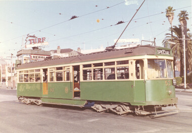
Photograph - tram VR 53 to MMTB 700 - set of 6, Norm Cross, 1975/76
Set of 6 photos by Norm Cross mid to late 1970s of VR class tram 53 and then MMTB 700 following its renumbering in 1975. 1 - VR 53 on an ARHS tour Carlisle St, St Kilda 21/3/1976 - has Turf and the Herald signs in the background. 2 - ditto in St Kilda Road, Nepean Highway with ARHS tour banners 3 - Tram 700 after repainting at Preston Workshops - June 1977 - note the route number. 4 - ditto 5 - Tram 700 Rosamond Road - running a Footscray Route 82 6 - Tram 700 at West Maribyrnong route 57Yields information about tram 53 and its conversion to No. 700 and the Essendon depot services that it was used on.Set of 6 colour photos, most with rounded corners.trams, tramways, vr class, tram 53, tram 700, st kilda, preston workshops, west maribyrnong, rosamond rd -
 Mt Dandenong & District Historical Society Inc.
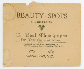
Photograph, Beauty Spots in Australia. Sassafras, c1913
This set of small photographs was produced by the Rose Stenograph Co. c1913 to be included in photograph albums. The area known as South Sassafras, was opened up for settlement in 1893 and the name was changed to Kallista in 1925.A small, paper envelope containing 12 photographs of Sassafras that are reproductions of Rose Series postcards. There are 10 different photographs, 32a and 32c have doubles.Envelope : BEAUTY SPOTS in AUSTRALIA 12 Real Photographs For Your Snapshot Album Published by the Rose Stenograph Co. Rear 17 Auburn Grove, Armadale, Vic 3.E.3 SASSAFRAS, VICTORIA Photograph 32a - THE ROSE SERIES P. 905 CLEMATIS AVENUE, SHERBROOKE, VIC. Photograph 32b - THE ROSE SERIES P. 1603 THE CASCADES, SASSAFRAS, VIC. Photograph 32c - THE ROSE SERIES P. 204 PANORAMA AT SASSAFRAS, VIC. Photograph 32d - THE ROSE SERIES P. 4046 MAIN ROAD, SASSAFRAS, VIC. Photograph 32e - THE ROSE SERIES P. 1502 SASSAFRAS CREEK, SASSAFRAS, VIC. Photograph 32f - THE ROSE SERIES P. 1501 TOURIST TRACK, SASSAFRAS, VIC. Photograph 32g - THE ROSE SERIES P. 4244 TOURIST TRACK, SOUTH SASSAFRAS, VIC. Photograph 32h - THE ROSE SERIES P. 2725 CLEMATIS AVENUE, SHERBROOKE, VIC. Photograph 32i - MAIN ROAD, SASSAFRAS, VIC. Photograph 32j - THE OLINDA - SASSAFRAS ROAD, VIC. rose series, rose series, sassafras, sherbrooke, sassafras creek -
 Glen Eira Historical Society
Document - Hawthorn Road, 284, Caulfield
Report dated 02/05/1988 about 284 Hawthorn Road, Caulfield by the Brighton Historical Society. It provides a history of this site from 1852 to 1974 including tenants and owners from 1923 to 1974. Handwritten working notes are included.hawthorn road, caulfield, mill road, maxwell nellie, glen john, stevens gar, watson george v.e., niblett thomas a., johnson stanley, williams millie, crawford walter h., usher gordon r., paton m.h. mrs., marriot, murray s., land sales, land subdivision, migrants, houses, tram services, bullock h. miss, landells r. miss -
Glen Eira Historical Society
Document - Hawthorn Road, 377, Caulfield
Valuation report dated 29/11/1965 for 377 Hawthorn Road Caulfield detailing land, improvements and general comments together with marked and rental values. This is a carbon copy with bottom of first page cropped and therefore is missing some lines.hawthorn road, caulfield, land use, factories, bakeries, bricks, rents and renting -
Glen Eira Historical Society
Article - Koornang Road, 51, Carnegie
A colour newspaper article identified as from the Property Review Weekly and dated 22/11/02, advertising the forthcoming auction of the dwelling and shop at 51 Koornang Road on 05/12/2002. The article includes a colour photograph of the building exterior.shops, carnegie, koornang road, carnegie railway station, auctions -
Glen Eira Historical Society
Document - Lovell House, Alma Road, 389 – 393
A photocopy of a typed extract from the Caulfield Conservation Study dated January 1995 by Andrew Ward regarding the history and architectural features of Lovell House in 389 – 393 Alma Road, Caulfield. A poorly copied photo of the exterior of the house is included.alma road, bagatelle, small major, caulfield, caulfield north, myoora, bruford martha, atta vista, cannon. m., small.c.h., bella vista, o’neil. lloyd, bruford elizabeth, adamsdown, grice john, lovell house, gilbert edith, schools, italianate style, oram william, independent schools, victorian style, mansions, gawler & drummond, macdonald hector, architectural styles, church of england, girl’s grammar school -
Glen Eira Historical Society
Document - Balaclava Road, 45, St Kilda East
Handwritten, undated and unattributed research notes on the architectural history and design of Balaclava Road, 45, St Kilda East. It describes the style of the house’s architect, Walter Burley Griffin and details the features and design of both the interior and exterior. Includes references.balaclava road, st kilda east, griffin walter barley, thompson henry, nichols e, houses, architecture, architectural styles, architectural features -
 Eltham District Historical Society Inc
Photograph, Jim Connor, Avenue of Honour, Main Road, Eltham, 3 Apr 2021
Former Eltham Courthouse, 730 Main Road immediately prior to major restoration works undertaken by Nillumbik Shire Council. The Courthouse is the oldest public building in the shire. It was built in 1860 and ceased operations as part of the Court of Petty Sessions in 1985.Tomorrow's history documented todayeltham, jim connor collection, main road, eltham gateway, eltham courthouse, eltham justice precinct, avenue of honour -
 Bendigo Military Museum
Souvenir - ADVERTISING CARD, The Fitzroy Tavern, C. WW2
Advertising card issued to visitors to the Fitzroy Tavern Windmill Street, Tottenham Court Road, London W.I. During and after WW2. Part of the Frederick Gardner Davey DFC RAAF collection. Refer Cat No 3536P for his service record..1) & .2) Rectangular cream paper with black type on front, type on front contains the business name, address and phone number. .1) On the back is a two verse poem. .2) on the back is a seven line ditty with an accompanying black silhouette picture of a man next to a car.souvenir, business card, tavern -
 Phillip Island and District Historical Society Inc.
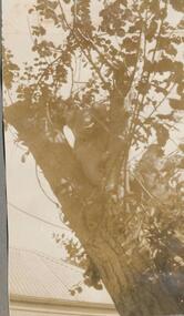
Photographs, 1926
Part of a collection of photographs cut from a photo album with multiple photos per page. Donated by Margaret Webster who's parents were Sir Charles & Lady McGrath. They lived near the RSL on Ventnor Road, Cowes Phillip Island.286-06 - Sepia photograph of a Koala in a tree in a backyard near a house. 286-07 - Sepia photograph of a motorcar and three people. 286-08 - Sepia photograph of a Koala in a tree in a backyard near a house. 286-09 - Sepia photograph of a group of 9 people outside the Continental Guesthouse in Cowes. 286-10 - Sepia photograph of the old sea baths at Cowes, Phillip Island. 286-11 - Sepia photograph of Cowes front beach at sunset. 286-06 - "Native Bears - Phillip Island" 286-09 - "Lovers' Walk Back Beach Cowes. The House Party Cowes." 286-10 - "The old baths - Cowes" 286-11 - "On the beach, Cowes. At sunset, Cowes."koala, wildlife - koala, the continental guesthouse, cowes sea baths, cowes beach, margaret webster -
 Mission to Seafarers Victoria
Photograph, Portland Guardian (1842-1964), 30 June 1962
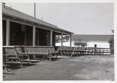
The Port of Portland opened in 1959. Straight after the Mission had the desire to establish a Mission at this location. A building was found in November 1961 on Cliff Road (AR 1961). After alterations and renovations, it was officially dedicated and opened the 30 June 1962. The Portland Mission was the fourth building to be opened in Victoria.small b & w photograph depicting outdoor empty chair setup for Mission to Seafarers outdoor service.stamp: K7020portland-victoria, 1962, dedication, opening -
 Mission to Seafarers Victoria
Photograph - Photograph, Black and white, Portland Guardian (1842-1964), 30 June 1962
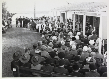
The Port of Portland opened in 1959. Straight after the Mission had the desire to establish a Mission at this location. A building was found in November 1961 on Cliff Road (AR 1961). After alterations and renovations, it was officially dedicated and opened the 30 June 1962. The Portland Mission was the fourth building to be opened in Victoriasmall b & w photograph depicting outdoor Mission to Seafarers church service, with attendees seated in chairs.stamp: "PORTLAND GUARDIAN" PHOTO / COPYRIGHTportland-victoria, 1962, victoria, opening, dedication -
 Mission to Seafarers Victoria
Photograph - Photograph, Black and white, Portland Guardian (1842-1964), 30 June 1962
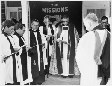
The Port of Portland opened in 1959. Straight after the Mission had the desire to establish a Mission at this location. A building was found in November 1961 on Cliff Road (AR 1961). After alterations and renovations, it was officially dedicated and opened the 30 June 1962. The Portland Mission was the fourth building to be opened in Victoria.Large rectangular (landscape orientation) monochrome photo, depicting 6+ clergymen gathered in a 'U' shape, conducting an outdoor servicePortland Guardian stampmission to seamen, portland, victoria, 1962, dedication, opening -
 Greensborough Historical Society
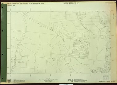
Map, Melbourne and Metropolitan Board of Works. Survey Division, MMBW, Yarra 2500 / 17.26. Hurstbridge, 1978_01
Melbourne and Metropolitan Board of Works. Yarra 2500 [base map] 17-26. Hurstbridge. Municipalities of Diamond Valley 257 and Eltham 238. Prominent streets include: Flat Rock Road and Heather Avenue. Includes Hurstbridge Railway Station.MMBW Map in 1:2500 [scale] series. Cream parchment with green tape reinforcing on edges and punched holes on left edge.mmbw, melbourne and metropolitan board of works, shire of diamond valley, hurstbridge - maps -
 Greensborough Historical Society
Correspondence and notice, Devonshire Road/Lambourne Road 5 storey development, 2004_03
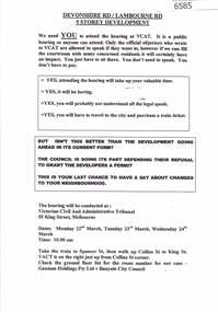
In 2003 an application by Gamut Holdings for a 5 storey building consisting of apartments, medical centre, shops and cafe on a site on the corner of Lambourn and Devonshire Roads Watsonia was approved by VCAT despite strong local opposition. These documents relate to the VCAT hearingCorrespondence relating to VCAT hearing P2461/2003, addressed to R Bray and notice to residents re hearingwatsonia, lambourn road watsonia, devonshire road watsonia -
 Greensborough Historical Society
Map, Melbourne and Metropolitan Board of Works. Survey Division, MMBW, Yarra 2500 / 16.27. Hurstbridge, 1977_10
Melbourne and Metropolitan Board of Works. Yarra 2500 [base map] 16.27. Hurstbridge. Parish of Greensborough 2724. Municipalities of Whittlesea 239 and Diamond Valley 257. Prominent streets include: Haleys Gully Road, Kendalls Lane and Bingley Avenue. MMBW Map in 1:2500 [scale] series. Cream parchment with green tape reinforcing on edges and punched holes on left edge.mmbw, melbourne and metropolitan board of works, shire of diamond valley, shire of whittlesea, hurstbridge - maps -
 Greensborough Historical Society
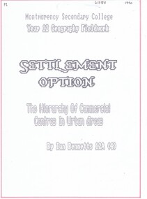
Folder, Ian Bennetts, Settlement option: the hierarchy of commercial centres in urban areas, by Ian Bennetts, 1990_
Year 12 Geography Fieldwork assignment aims: (1) to establish if there is a hierarchy of commercial centres in the Greensborough area, and (2) to establish the hinterlands of selected commercial centres in the Greensborough area. Centres studied are: Briar Hill, Greensborough, Looker Road and Montmorency47 p. typescript, coloured diagrams and photographs in looseleaf foldergreensborough, briar hill, montmorency, looker road montmorency -
 Yendon History Group
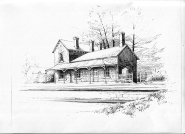
Ink drawing, Jenny John, 6:MMMM, 2010 (exact)
A pen and ink drawing by Jenny John of the Yendon Railway Station composed from photographs taken of five other stations of the same or similar design. Used as the picture on the interpretive sign installed at the station site, Harbours Road Yendon, in 2011.Pen and ink drawing of the Yendon Railway Station by artist Jenny John A3 in size.Signed by Jenny John at bottom right hand sideink drawing, yendon railway station, john jenny -
 Eltham District Historical Society Inc
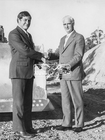
Photograph, Mr. B. O'Regan, Manager of A.N.Z Eltham with Cr. J.O. White, Eltham Shire President, 4 July 1973
Cheque being presented to Shire of Eltham Councillor J.O. White by the Manager of the ANZ Bank, Mr B. O'Regan. Funds were in the form of a loan (Loan no 99) part of which was to be used or reconstruction of the Kangaroo Ground-Wattle Glen Road.This photo forms part of a collection of photographs gathered by the Shire of Eltham for their centenary project book, "Pioneers and Painters: 100 years of the Shire of Eltham" by Alan Marshall (1971). The collection of over 500 images is held in partnership between Eltham District Historical Society and Yarra Plenty Regional Library (Eltham Library) and is now formally known as 'The Shire of Eltham Pioneers Photograph Collection.' It is significant in being the first community sourced collection representing the places and people of the Shire's first one hundred years.Digital image Print 21.5 x 16.5 cm (Held at Eltham Library)sepp, shire of eltham pioneers photograph collection, eltham, cr. j.o. white, presentation, cheque, finance, anz bank, b. o'regan -
 Eltham District Historical Society Inc
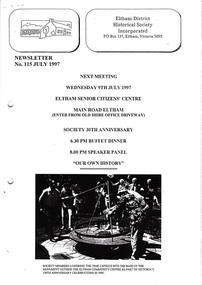
Newsletter, Newsletter, No. 115 July 1997
Contents: • Next meeting, Speaker Panel: Our Own History • 30th Anniversary Meeting • 728 Main Road • Constructing the Plenty Valley • Sweeneys • Andrew Ross Museum • A Thank You by Gwen Baker • Some Other News Items The Shire of Eltham Historical Society was formed in October 1967. The first newsletter of the Society was issued May 1978 and has been published continuously ever since on a bi-monthly basis. With the cessation of the Shire of Eltham in late 1994, the Society's name was revised to Eltham District Historical Society and this name first appeared with issue No. 103, July 1995. The collection of the Society's newsletters provides a valuable resource on the history of the Society's activities, office bearers and committee members, guest speakers and subjects of historical interest pertinent to the former Shire of Eltham and the Eltham District.A4 photocopied newsletter distributed to membersnewsletter, eltham district historical society, shire of eltham historical society -
 Eltham District Historical Society Inc
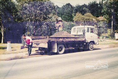
Photograph, Road Maintenance
One of a set of display images thought to be produced by the Shire of Eltham c.1979-1987. Council worker filling a pot hole on the side of a road with gravel from the back of a truck. There is a fire hydrant close by. Exact street location unknown.Illustrative of services provided by former Shire of ElthamColour photograph 20 x 29 cm mounted on green-painted chipboard 28 x 35.5 cm (string on back for hanging)Title printed on label adhered to board below photograph (replaced June 2017)road maintenance -
 Marysville & District Historical Society
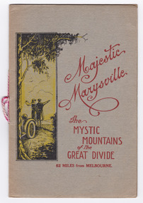
Booklet (Item) - Information booklet, Marysville Tourist Association, Majestic Marysville The Mystic Mountains of the Great Divide 62 Miles from Melbourne, Unknown
An information booklet on various attractions in and around Marysville and the district which was produced by the Marysville Tourist Association. The Association was formed in November 1907 to promote tourism within the area. This included the physical creation of signage, parklands, roads and walks to various attractions. An information booklet on various attractions in and around Marysville and the district which was produced by the Marysville Tourist Association.FRANK ENDACOTT/ Healesvillemarysville, victoria, mystic mountains, great divide, steavenson falls, keppel falls, cameron cascades, cumberland, mt cathedral, triangle, eildon weir, snob's falls, wolfram mine, mt strickland, keppel's lookout, mt kitchener, mt edgar, oxlee's lookout, mt gordon, nichol's lookout, michael dene, beauty spot, gilbert's gully, taggerty river, buxton road -
Glen Eira Historical Society
Document - Topp Family
Handwritten list of accomplishments and spouses of Topp family, notes from the VIC AND MET VZ pg. 505. Also includes handwritten page of research on history of Topp family in Shoobra road, written by Claire Barton, 19/02/2013shoobra road, topp charles alfred, topp samuel, topp louisa -
Glen Eira Historical Society
Document - Shoobra Road, 88, Elsternwick
This file contains one item: 1/Typed history of streets surrounding Shoobra Road, and brief history of area. Gives listings of owners of property from Brighton Historical Society researchers. Handwritten working notes also of same details.shoobra road, elsternwick, gisbourne street, glen huntly road, railway crescent, gladstone parade, ‘cavers carre’, riddell john carre (mla), riddell walter carre, riddell crescent, orrong road, riddell parade, brook samuel, morris albert e., moreland elizabeth mrs., scott w. thomas, burn mrs., lewis kenneth, bullock hilary, londells rosemary -
Stawell Historical Society Inc
Book - Guide Book, The Emigrant's Friend
Faxsimile Reprint of 1848 booklet printed in London J. Allen warwick, Paternoster Row: D. Francis Mile End Road. May be had of all Booksellers. Inlcudes what Emigrant must provide at minimum when on passage to the colonies.Paper Back, Fawn cover: Brown print Seals of Australia, New Zealand, Van Dieman's Land, and the Seal of Swan River.Seal of New Zealand Seal of Australia [Picture of Seal] [Picture of Seal] The Emigrants friend or Authentic Guide to South Australia Including Sydney: Port Philip or Australia Felix: Western Australia, or Swan River Colony: New South Wales: Van Dieman's Land; and New Zealand original published in London in 1848. Recreated by Reader's Digest Sydney [Picture of Seal] [Picture of Seal] Seal of Van Dieman's Land [Seal of Swan River] -
National Wool Museum
T-shirt
Australian womens top/t-shirt from the formal uniform for the Sydney 2000 Olympic Games. Manufactured by Blossom Road Pty Ltd from Colana yarn (a wool/cotton blend) from Rocklea Spinning Mills Pty Ltd.fashion, woolmark company blossom road pty ltd, sport, the woolmark company 2000 australian olympic display - exhibition (21/12/2001 - 24/05/2002) -
 Kew Historical Society Inc
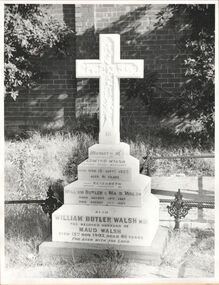
Photograph, Walsh grave, Boroondara General Cemetery, circa 1965, c. 1965
Dr William Butler Walsh was born in 1854. He bought from James Venn Morgan on the corner of Charles Street and Cotham Road and in 1886 built Wilton on this site. He was at one stage the only doctor between Melbourne and Lilydale.This work forms part of the collection assembled by the historian Dorothy Rogers, that was donated to the Kew Historical Society by her son John Rogers in 2015. The manuscripts, photographs, maps, and documents were sourced by her from both family and local collections or produced as references for her print publications. Many were directly used by Rogers in writing ‘Lovely Old Homes of Kew’ (1961) and 'A History of Kew' (1973), or the numerous articles on local history that she produced for suburban newspapers. Most of the photographs in the collection include detailed annotations in her hand. The Rogers Collection provides a comprehensive insight into the working habits of a historian in the 1960s and 1970s. Together it forms the largest privately-donated collection within the archives of the Kew Historical Society.Grave of the Walsh family in the Boroondara General Cemeterywilliam butler walsh, boroondara general cemetery, dorothy rogers, kew cemetery -
 Port Fairy Historical Society Museum and Archives
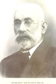
Photograph, Cr P McGrath Shire of Belfast President 1879-80-81, 82-83
Councillor P.McGrath lived on the Koroit-Woolsthorpe Road and engaged in farming pursuits. He gained fame by his masterly handling of the subdivision of the Shire into 3 Ridings practically of equal valuation and they remained that way until the amalgamation of the shire and the Borough council.Black and white portraitgovernment, belfast, president, portrait, shire, council, municipal, local-government -
 The Beechworth Burke Museum Research Collection
Card (Series) - Index Card, George Tibbits, Stanley Road, Beechworth, 1976
George Tibbits, University of Melbourne. Faculty of Architecture, Building and Town & Regional PlanningIndex system that support the research for Beechworth : historical reconstruction / [by] George Tibbits ... [et al]Arranged by street names of BeechworthEach index card includes: street name and number of property, image of property, allotment and section number, property owners and dates of ownership, description of the property according to rate records, property floor plan with dimensions.beechworth, george tibbitsbeechworth, george tibbits -
 Ballarat Tramway Museum
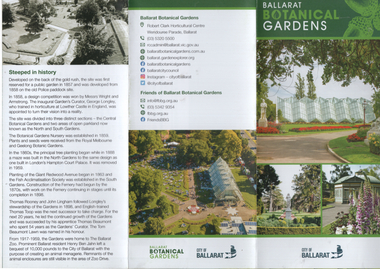
Pamphlet, Friends of the Botanical Gardens, "Ballarat Botanical Gardens", c2020
Pamphlet giving details of specific areas of the Ballarat Botanic Gardens, published by the Friends of the Ballarat Botanical Gardens, in conjunction with the City of Ballarat. Includes the Ballarat Tramway Museum with a small image of tram 40 on No. 3 road at the depot. Undated - c2020.Provides infomation about the Ballarat Botanical GardensSix fold A3 to DL pamphlet, full colour.trams, tramways, gardens, botanical gardens