Showing 1550 items matching " aerial photographs"
-
 Old Colonists' Association of Ballarat Inc.
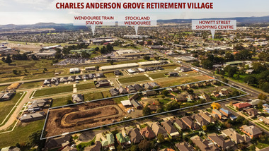
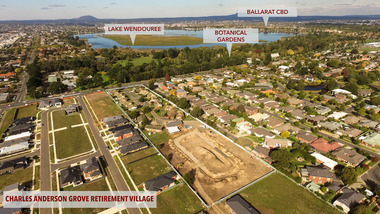
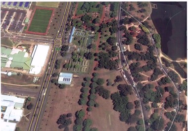
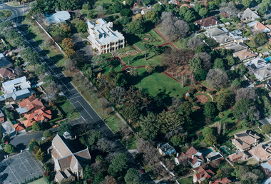
Photograph - Photograph - Colour, Aerial View of Charles Anderson Grove, Ballarat, 2017, 05/2017
Drone footoge featuring the Old Colonists' Association of Ballarat Inc., retirement village at Charles Anderson Grove. The area to the left is being prepared for 18 additional cottages to be built. old colonists' association of ballarat, drone footage, ballarat, aerial, charles anderson grove, retirement village -
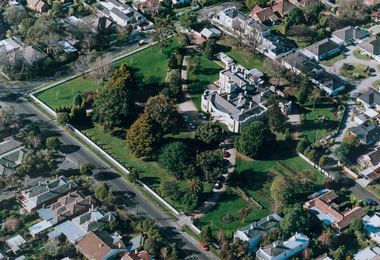
 Old Colonists' Association of Ballarat Inc.
Photograph - Photograph - Colour, Aerial View of Charles Anderson Grove Retirement Village, Ballarat, 2017, 05/2017
Drone footage of Charles Anderson Grove Retirement Village off Gillies Street, Ballarat.charles anderson grove, old colonists' association, ballarat, drone footage, aerial, ballarat, retirement village -
 Tramways/East Melbourne RSL Sub Branch - RSL Victoria Listing id: 27511
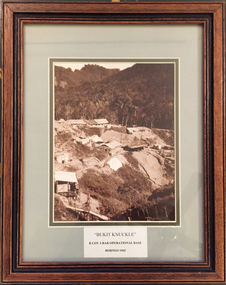
Picture, Bukit Knuckle
Framed print of a sepia photograph showing the camp at 'Bukit Knuckle', an operational base of the 3RAR in Borneo. Images shows an aerial view of the camp and surrounding landscape. Underneath the print is added 'BUKIT KNUCKLE' B COV 3RAR OPERATIONAL BASE, BORNEO 1965 On reverse is marked 'Donated by Keith Matthews 1995'bukit knuckle, sungei koemba, 3 rar, indonesia malaysia confrontation -
 Magnet Galleries Melbourne Inc
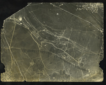
birdseye aerial photograph
... birdseye aerial photograph..., field, aerial view, aviation, bomb, bombing birdseye aerial ...world war 1, anzac, ww1, soldiers, australian, field, aerial view, aviation, bomb, bombing -
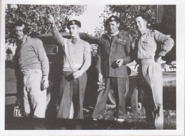 8th/13th Victorian Mounted Rifles Regimental Collection
Photograph
The 8th/13th Victorian Mounted Rifles was raised as a regiment of the Royal Australian Armoured Corps on 1 May 1948 with Headquarters in Melbourne and squadrons in Sale, Benalla/Wangaratta and Albury. In 1955 Regimental Headquarters moved to Wangaratta and a second squadron was located at Albury. The Sale squadron transferred to 4th/19th Prince of Wales’s Light Horse. In 1977 8/13 VMR Regiment was reduced to an independent squadron A Squadron 8th/13th Victorian Mounted Rifles and in 1991 was linked with 4th/19th Prince of Wales’s Light Horse forming the VMR Squadron of that regiment.Unique collection of photographs showing the first years of an armoured regiment of the post-Second World War era Citizen Military Forces showing equipment, uniforms, training and social activity and some personalities.Black and white photograph of four soldiers in variety of uniforms standing beside civilian utility vehicle. One is wearing winter service dress, one in khaki drill uniform, two are wearing V neck Army jumpers. One is wearing headphones, one haslength of radio aerial. One of a collection of photographs of 8th/13th Victorian Mounted Rifles Regiment between 1948 and 1951." Cunningham Alternative Command Vehicle. No. 1 Set Training. John Neale, George Atkinson, Bill Purcell, Ron Braddy. " -
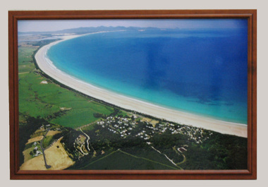 South Gippsland Shire Council
Photograph, Framed, 2003
... Framed colour photograph featuring an aerial view... gippsland Framed colour photograph featuring an aerial view ...Framed colour photograph featuring an aerial view of Waratah Bay, the beach and Sandy Point . Wilsons Promontory can be seen in the distance. -
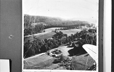 Southern Sherbrooke Historical Society Inc.
Photograph, Aerial view of Cotswold Valley
Aerial view of Cotswold Valley, Menzies Creek. B&W photos taken from light plane. Paddocks and treed areas are visible. Two houses are in the centre of the photo, presumably the Breen farmhouse on Jacksons Hill Road. The tip of the plane's left wing is also visible. -
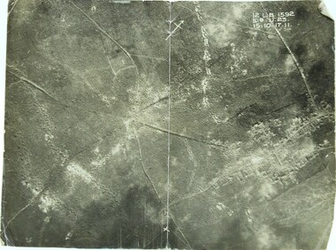 Ringwood RSL Sub-Branch
Photograph WW1, Aerial photograph
... Aerial photograph... melbourne 12 L.B. 1592 51B.U.23. 15.10.17.11 WW1 front line Aerial ...WW1 front line12 L.B. 1592 51B.U.23. 15.10.17.11 -
 Moorabbin Air Museum
Photograph (Item) - Assorted Aerial Photos Of Lae, Rabaul, Horn Island, Kahili, Buna, Gona , Ballale Island
... Moorabbin melbourne Assorted Aerial Photos Of Lae, Rabaul, Horn ... -
Moorabbin Air Museum
Photograph (Item) - Includes photos of Commonwealth aircraft Corp aerial photos, CAC photos of Macchi MB326H trainer Bell 206 Kiowa
-
 Ballarat Tramway Museum
Photograph - Colour Print, Google Earth, Jan. 2015
Yields information about the South Gardens Reserve and the BTM, including Depot Junction following its redevelopment late 2014.Laminated colour photograph of the South Gardens Reserve Precinct, showing the revised depot junction - completed late Dec. 2014, the fish hatchery, the tram depot with Solar panels, Nov. 2014. Image downloaded from Google Earth 31/3/2015. Has a single trucker on 2 road and 939 on 3 road. See images i2 and i3 for other digital photos prepared from Google Earth at the same time. Image i2 has the solar panels marked by a red arrow.trams, tramways, btm, depot junction, aerial views, solar panels, gardens, fish hatchery -
 Ballarat Tramway Museum
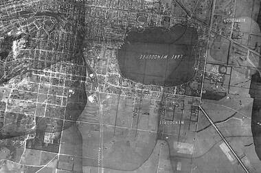
Photograph - Black & White Photograph/s, State of Victoria Lands Department, c1940
... Black and white photograph of an aerial view of the Lake... the development and Lake Wendouree from an aerial photograph c1940. Trams ...Yields information about the development and Lake Wendouree from an aerial photograph c1940.Black and white photograph of an aerial view of the Lake Wendouree and the northern part of Ballarat c1940. Shows the photograph join lines, has names of suburbs, Railway lines. Purchased from rusty via Ebay 16/5/2019.trams, tramways, lake wendouree, ballarat, aerial views -
Moorabbin Air Museum
Photograph (Item) - Photograph album pre WW 2 small prints aerial shots of Melbourne and assorted aircraft
-
 Ballarat Tramway Museum
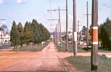
Slide - 35mm slide/s, Graham Evans, Sep. 1971
Agfa plastic mount (blue base, white cover) of a photograph of a bogie tram on the reserved track between Ophir St and the terminus - telephoto lens. Note tram stop signs, aerial phone lines, the condition of the track and the gravel crossings. Photo taken 9/1971. See also M. Plummer slides Reg. Item 2160 for similar photograph with No. 17. One of a set of 20 slides made by the Association of Railway Enthusiast Provincial Tramways film strip. Reference Item 2560 details the ARE Film Strip and provide references to other slides. Slide rescanned at 3200 dpi 25-10-2020, jpg replaced, tiff file retained. This file was scanned in 2003 and may show colour changes."BAS 70" in pencil.tramways, trams, albert st., sebastopol, ophir st -
 Ballarat Tramway Museum
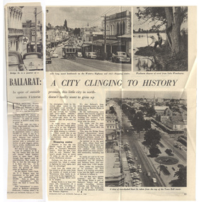
Magazine, Woman's Day, "Ballarat a City Clinging to History", 8/02/1960 12:00:00 AM
Yields information about the viewpoint of The Courier about the future of the Ballarat tramway system with reference to Geelong.Part page 14 and page 15 of an article titled "Ballarat a City Clinging to History" from the Woman's Day, 8/2/1960, featuring a photograph No. 30, descending Bakery Hill to Bridge St, an aerial view looking west from the Town Hall down and workmen pulling weed from Lake Wendouree. Item looks at Ballarat's history, population, future, Bridge St, the bottleneck of bridge St, quotes Deputy Town Clerk, F. Rogers, and whether the city should grow. Interesting views of traffic in Bridge St. Also quotes Paul Simon of the Bridge St Traders Association. Contained originally within Reg Item 5507 at the back of the binder. For items see btm5507 loose items list.pdftrams, tramways, ballarat, bridge st, bridge st traders -
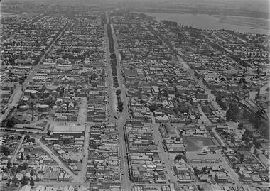 Ballarat Tramway Museum
Photograph - Digital image, c1925
... Ballarat c1925 from an aerial photograph looking west. Trams ...Yields information about Ballarat c1925 from an aerial photograph looking west.Digital photograph of Ballarat looking West c1925, aerial view, looking along Sturt St and Bridge St, taken from about Victoria St and Humffray St. Shows both the Alfred Hall and the Coliseum. Shows two single truckers at the east end of Sturt St. See email from Alan Bradley dated 28/7/2012 re date. See also Reg Item 5454 for another similar photograph.trams, tramways, ballarat, aerial views -
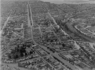 Ballarat Tramway Museum
Photograph - Digital image, c1925
... Ballarat c1925 from an aerial photograph looking west. Trams ...Yields information about Ballarat c1925 from an aerial photograph looking west.Digital photograph of Ballarat looking West c1925, aerial view, looking along Sturt St and Bridge St, taken from about Eureka and Kings St. Shows both the Alfred Hall, the Railway Station, Sunshine Biscuits and the Coliseum. Shows two single truckers at the east end of Sturt St and two at the west end of Bridge St or Grenville St. See email from Alan Bradley dated 28/7/2012 re date. See also Reg Item 5453 for another similar photograph.trams, tramways, ballarat, aerial views -
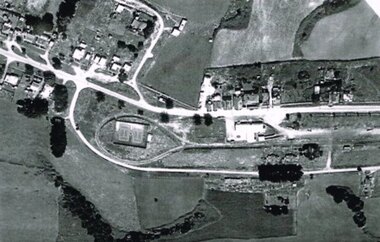 Otway Districts Historical Society
Photograph, R. Preston, Aerial view of Beech Forest railway station and yards, 1965, 13 February 1965
B/W. An aerial view of Beech Forest showing the balloon loop at the end of the station yard (enclosing the two tennis courts), two ex-departmental residences, the station buildings, and other aspects of the township.beech forest: railways; township; aerial; -
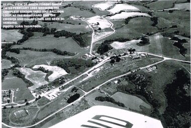 Otway Districts Historical Society
Photograph, R. Preston, Aerial view: Beech Forest, 1965, 13 February 1965
B/W. Aerial view of Beech Forest showing the complete station yard including the balloon loop (incorporating the two tennis courts), two ex-departmental residences, the station building and where the Colac and Crowes lines diverged. As well Beech Forest Hall, council offices and Shire Secretary's house, Denherts Track, and Main Road are shown.beech forest; railways; township; aerial; -
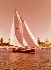 Queenscliffe Maritime Museum
photograph - Photo of Couta boat AERIEL at Portland, AERIEL at Portland, 1986
Couta boatsGarry Kerr's Couta boat AERIAL at Portland, under sail.5 x Colour photographs of the Couta boat AERIAL, owned by Garry Kerr, at PortlandReverse - " NIL "historical references -
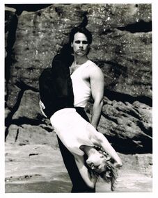 Bendigo Historical Society Inc.
Photograph - MERLE HALL COLLECTION: PHOTOGAPHS OF PAUL MERCURIO (AND PARTNER)
... is of eight performers in vibrant dance poses (mostly aerial). Two ...a. And b. Identical B&W photgraphs of Paul Mercurio and partner (different sizes) Both with typewritten annotation ''Paul Mercurio who will be touring Victoria with his own dance company is pictured with partner Jan Pinkerton. The Australian Choreographic Ensemble have already played a successful season in Sydney and will dance in Melbourne prior to the Victorian tour''. Picture of Mercurio (standing) holding a downwards facing partner in front of rock backdrop.c.: photo of ''the lively young and exuberant dance company formed by Strictly Ballroom star Paul Mercurio limber up before a rehearsal. Annotation - ''the company are preparing to dance their way around Victoria from March 15''. Photo is of eight performers in vibrant dance poses (mostly aerial). Two advertising brochures. -
 Bayside Gallery - Bayside City Council Art & Heritage Collection
Photograph - type C photograph, Newmark Aerial Photography, Kamesburgh, North Road, Brighton, 1996
... Kamesburgh North Road Brighton Historic House Aerial Photograph ...kamesburgh, north road, brighton, historic house, aerial, photograph, newmark aerial photography, anzac hostel, william kerr thomson, lloyd tayler, italianate, streets -
 Bayside Gallery - Bayside City Council Art & Heritage Collection
Photograph - type C photograph, Newmark Aerial Photography, Billilla, Halifax Street, Brighton, 1996
... brighton historic house aerial photograph newmark aerial ...brighton, historic house, aerial, photograph, newmark aerial photography, streets, billilla, weatherly, william weatherly, smith and johnson, walter richmond butler, halifax street -
 Bayside Gallery - Bayside City Council Art & Heritage Collection
Photograph - type C photograph, Newmark Aerial Photography, Brighton Town Hall, Wilson Street, Brighton, 1996
... brighton aerial photograph newmark aerial photography streets ...brighton, aerial, photograph, newmark aerial photography, streets, brighton town hall, brighton library, brighton court house, court house, library, gardens, wilson street, carpenter street, boxshall street, khyatt's hotel, council chambers, brighton police station -
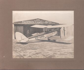 Bendigo Historical Society Inc.
Photograph - T.B.T. Aviation Co
The Bendigo Aero Club laid out the Myers Flat aerodrome in 1929 to serve as an airport for Northern Victoria and the Riverina. In May 1929, 12 machines arrived to give an aerial display to local citizenry.Black and white photograph glued to brown cardboard. Photo of a single engine propeller plane in front of a shed. The sign on the shed reads: T.B.T. Aviation Co. Passenger flights from 10 shillings every Saturday, Sunday and Holiday. Markings on the plane: VH-UHG Eaglehawk. Two men are standing, and one is in the cockpit of the plane. Part of the Barker's family collection.At "Drome" Myers Flat. Left to right: O'Halloran, Cyril James (brother of Emmie Barker nee James), J.S. Barker.myers flat, aviation, tbt aviation -
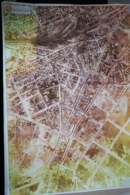 Bendigo Historical Society Inc.
Map - BENDIGO MAP AERIAL VIEW, 1934
... PHOTOGRAPH Aerial bendigo 1934 Map of Bendigo. Aerial View of Bendigo ...Map of Bendigo. Aerial View of Bendigo taken in 1934. Published by City of Great Bendigo.photograph, aerial, bendigo 1934 -
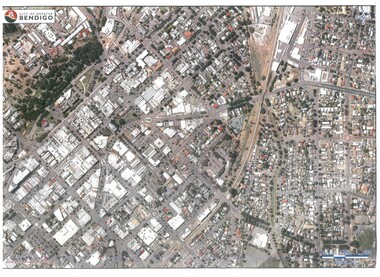 Bendigo Historical Society Inc.
Map - BENDIGO MAP AERIAL VIEW
... PHOTOGRAPH Aerial bendigo Map of Bendigo. Aerial View of Bendigo ...Map of Bendigo. Aerial View of Bendigo. Published by City of Bendigo. Undated.photograph, aerial, bendigo -
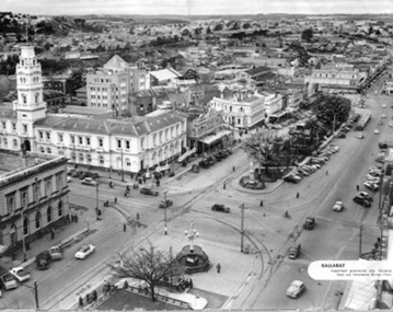 Ballarat Tramway Museum
Photograph - Illustration/s, News and Information Bureau - Photo, Ballarat view from Town Hall, Oct. 1958
Yields information about the Sturt and Lydiard St streetscape from the Town Hall, c1958.Photograph of intersection of Sturt St and Lydiard St from Town Hall. Looking north east to Black Hill. See also item with Reg. No. 667 of similar but earlier view. Photo is inside cover of ANZ quarterly survey, dated Oct. 1958. Shows four trams in City Loop and good photo of trackwork and motor cars of period. Not to be displayed - before copy neg made.Ballarat - important Provincial Citytrams, tramways, sturt st, black hill, aerial views, trackwork -
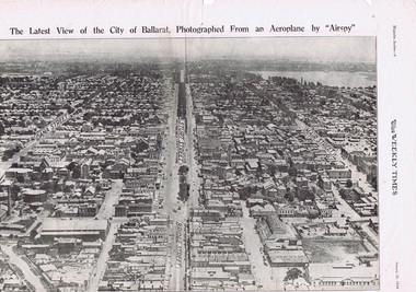 Ballarat Tramway Museum
Photograph - Illustration/s, Herald & Weekly Times Ltd, Sturt St. Aerial View, 1934, Jan. 1934
... . Sturt St. Aerial View, 1934 Photograph Illustration/s Herald ...Yields information about Ballarat from the eastern aspect of the city looking west in an aerial view dated 1934. Shows buildings such as the Gas Works and other buildings that no longer exist.Photographic reproduction of Ballarat looking west down Sturt St., page 6 of Magazine section of Weekly Times, Jan 20, 1934. On rear is two colour photo of Alexandria Avenue, Melbourne. Record updated and image added 21/9/2013.trams, tramways, ballarat, sturt st., aerial views -
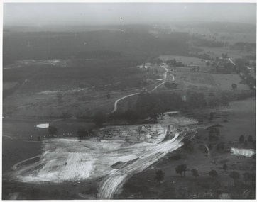 Buninyong & District Historical Society
Photograph - Original Photograph, N.L. Harvey and Sons, Ballarat, B/W photo of early site works Mt. Helen Campus of University of Ballarat, 13 May 1968
Educational historyB/W aerial photo of early site works Mt. Helen Campus of University of Ballarat.On rear, "Tertiary Institute site work at Mt. Helen commenced March 1968 (see A.R. 1967-68, p.8 Knowles and Stapleton had earthworks contract" also stamp " N.L. Harvey & Son Photographers 131 Sturt Street Ballarat"buninyong, mt. helen, ballarat university, campus, earthworks