Showing 10989 items matching " land"
-
 Eltham District Historical Society Inc
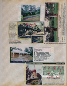
Newsclipping, Benwerrin, 24 Fordhams Road and 129 Mount Pleasant Road, Eltham South and Windmill Court Estate, Diamond Creek/Eltham North and The Oaks, 53 York Avenue, Ivanhoe
Contained in Volume 2 of a set of two spiral magnetic photo albums, each containing 10 leaves, 20 pages; Vol. 1 labelled "Houses - Eltham South" and Vol. 2 labelled "Eltham Houses". Newspaper clippings advertising house/land auctionseltham, real estate advertisement, houses, benwerrin, diamond creek, eltham north, fordhams road, ian reid real estate, ivanhoe, mount pleasant road, the oaks, windmill court -
 Eltham District Historical Society Inc
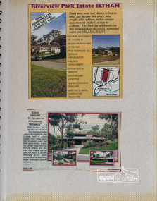
Newsclipping, Riverview Park Estate, Eltham
Contained in Volume 2 of a set of two spiral magnetic photo albums, each containing 10 leaves, 20 pages; Vol. 1 labelled "Houses - Eltham South" and Vol. 2 labelled "Eltham Houses". Newspaper clippings advertising house/land auctionseltham, real estate advertisement, houses, riverview park estate -
 Glenelg Shire Council Cultural Collection
Slide - Slide - Cashmore Airport, Portland, 1980s
Coloured photo. View of plane coming into land.portland airport, air travel, portland -
University of Melbourne, Burnley Campus Archives
Document, Resource Manual for Postgraduate Students, 2006
University of Melbourne, Faculty of Land and Food Resourcesstudents, postgraduates, university of melbourne, faculty of land and food resources -
Whitehorse Historical Society Inc.
Pamphlet, Blackburn Park, 1890
Copy of land sales brochure for Blackburn Park.Copy of land sales brochure for Blackburn Park.Copy of land sales brochure for Blackburn Park.freehold investment and banking company of australia ltd, morton, thomas richards burrowes, blackburn park -
Whitehorse Historical Society Inc.
Document, Schwerkolt's Cottage, 1970s
Typewritten description of the cottage history and surrounding land.Typewritten description of the cottage history and surrounding land.Typewritten description of the cottage history and surrounding land.schwerkolt cottage, schwerkolt's road -
 Federation University Art Collection
Print, Mary Wagenfield, Tugs, Ships and Control Towers, 2001
Mary WAGENFIELDA tug boat pulling away from the land.LL 1/3 Centre Tugs Ships and Control Towers LR mgw2000available, ships, tug boat, port -
 Melton City Libraries
Document, William John Clarke Lease, Unknown
Mr John Purchase came from Heidelberg, and was dairying on the east side of Melton, on the Footscray road, in the Braybrook Shire. His daughter married Mr Ralph Parkinson, J.P., Mr Purchase sold his farm to the late Sir William Clarke, and then went home to England with his wife; his son, John, stopped in Victoria.Copy of a William John Clarke's purchase of landlocal identities -
 Bendigo Historical Society Inc.
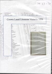
Archive - CROWN LAND LICENCES VICTORIA, 1856, 1856
DVD - Crown land licenses Victoria 1856crown land, licences 1856 -
 Bendigo Historical Society Inc.
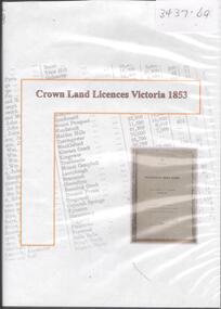
Archive - CROWN LAND LICENCES VICTORIA 1853, 1853
DVD. Crown land Licences Victoria, 1853. -
 Bendigo Historical Society Inc.
Archive - LAND SALES, 21 April 2016
DVD. Land sales to 21st April 2016. -
 Bendigo Military Museum
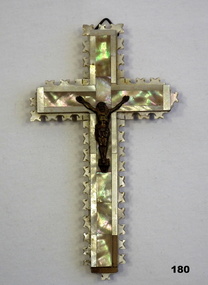
Souvenir - CRUCIFIX, 1939-45
Souvenir from The Holy Land brought home by Eric L. BUGGE VX6316. Refer 181 for his service history.Wooden crucifix, brass figure of Christ glued on front. 4 pieces of laminated wood with decorative edging, decorative top layer of mother-of-pearl. Lower right-hand corner & edge missing. Hanger at top.Souvenir from the Holy Land. Brought home by Eric L. Bugge.Rear: "Jerusalem" 14 circles with strange hieroglyphics.religion-christian, souvenirs, handcrafts -
Whitehorse Historical Society Inc.
Map, Nunawading. County of Bourke, 1878
Photocopy of map of Shire of Nunawading.Photocopy of map of Shire of Nunawading. Note: Fosters v President of the Shire of Nunawading. On Verso: Copied from the most up to date by the Dept of Lands, 1878. Laid before the Executive Council, 11 June 1878. Shows land holders.Photocopy of map of Shire of Nunawading.shire of nunawading, maps -
 Whitehorse Historical Society Inc.
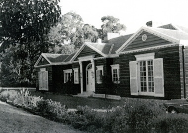
Photograph, Roger de Stoop
Roger de Stoop had the land cleared in 1952 and building started in 1953. He and his family moved in in 1954. The house has now been demolished but it was about 35 squares, was made of timber with blue slate roof, the slates having come from Belgium. Roger de Stoop had his outside timber walls painted in a dark colour.Black and white photocopy of house built by Roger de Stoop on land in Blackburn North (Henry Street - later 35 Middlefield Road). The house was called Middlefield House by local people.de stoop. roger. middlefield house -
 Sunbury Family History and Heritage Society Inc.
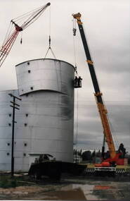
Photograph, Wheat silo, c1984
A wheat silo was erected on railway land adjacent to the Sunbury Station in 1967. Frank Millett handled the operations. As bulk handling was the preferred way to transport wheat, the silo gave local cereal growers to deliver their grain to the railhead. Over the years of the operation 200 grain wagons delivered wheat annually to the silo. In 1984 the silo was dismantled and removed.Cereal growing was one of the agricultural activities carried out in the Sunbury and surrounding areas for many years.A non-digital coloured photograph of a metal wheat silo being dismantled. A crane is beside the silo and two men are suspended from the crane in a basket to ensure that the sheets of iron land safely on the truck. wheat storage, silos, frank millett, cereal crops, sunbury railway station -
Linton and District Historical Society Inc
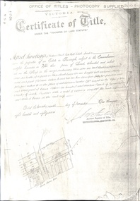
Certificate of Title, Certificate of Title: Allotment 36, Section 4, Township of Linton
Title of the land was transferred to James Adolphus Nelson and Theophilus William Nelson in 1955. James and Theo Nelson had already purchased adjacent allotments 27 - 30 in 1929.Copy of a Certificate of Title for an allotment of land situated between Grantley Street and Springdallah Creek in Linton. Copy comprised of three photostat sheets held together by tape. Most recent holders of the Title recorded as James Adolphus Nelson and Theophilus William Nelson.certificates of title, allotment 36 section 4 township of linton, james adolphus nelson, theophilus william nelson -
 Victorian Aboriginal Corporation for Languages
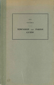
Book, Department of Crown Lands and Survey Victoria, Township and parish guide : Victoria, 1955
A alphabetical list of townships proclaimed under the Land Acts of Victoria. Shows the parish, land district and the municipality in which each is situated, and the particulars of Gazettal of Proclamation.victorian geographical names, victorian administration -
 Whitehorse Historical Society Inc.
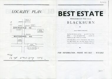
Document, Best Estate, n.d
sale of land at Best Estate, Blackburn North. Part of the original land holdings of R. de Stoop and R. Best of British Fur Co.Advertisement for sale of land at Best Estate, Blackburn North. Part of the original land holdings of R. de Stoop and R. Best of British Fur Co.sale of land at Best Estate, Blackburn North. Part of the original land holdings of R. de Stoop and R. Best of British Fur Co.land subdivision, best estate, blackburn north, chapman street, middleborough road, joseph street, nestor grove, vivian street, de stoop, roger, best, richard, british fur company -
 Whitehorse Historical Society Inc.
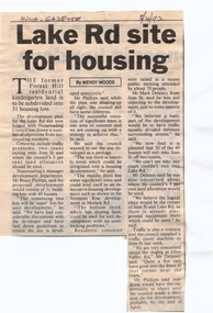
Article, Lake Rd Site for Housing, 8/04/1992 12:00:00 AM
Lake Rd Site for Housing.An article in the Nunawading Gazette on an objection by Mark Delaney on the traffic flow and hazards associated with the proposed development of land on the former Forest Hill Residential Kindergarten land.Lake Rd Site for Housing.land subdivision, forest hill residential kindergarten, lake road, forest hill, jean street, phillips, bruce, delaney, mark, glen valley road -
 Whitehorse Historical Society Inc.
Document - Land Title, Certificate of Title, 29/11/1887
Photocopies of land titles involved in subdivision of land on the north-west corner of Whitehorse Road and Mitcham Road including Britannia Street. A list of purchasers is included.mitcham road, mitcham, whitehorse road, britannia street, rawlings, alfred, frost, john, richards, thomas, leech, george arthur, smith, reed, richard louis, young, frederick, hughes, doery, george henry, mitcham primary school, no. 2904, land subdivision -
Lakes Entrance Historical Society
Book, Morrissey, D.W and Morrissey E.W, Lakes Entrance a Short History revised Edition, 1980
History of Koorie inhabitants through to fishing industry, timber industry, early settlers and survey and sale of land. The opening of the entrance to allow shipping industry to operate bringing much trade and movement of primary produce etc. Local schoolHistory of Koorie inhabitants through to fishing industry, timber industry, early settlers and survey and sale of land. The opening of the entrance to allow shipping industry to operate bringing much trade and movement of primary produce etc. Local schoolMargaret Campbell''land settlement, religion, aboriginals -
 Bendigo Military Museum
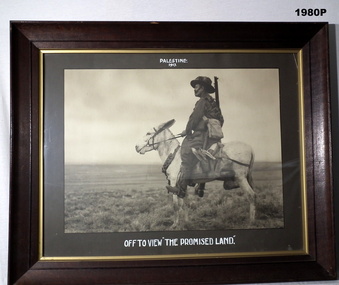
Photograph - PHOTOGRAPH WW1, FRAMED, c.1917
Heavy wooden frame, glass front, khaki coloured border, black & white photo of an Australian Light Horse Soldier on a donkey with a bandolier of extra ammunition around its neck.Top "Palestine 1917". Bottom, "Off to view the Promised land"photography-photographs, military history - army, palestine -
Coal Creek Community Park & Museum
Tin container, Stephen F. WHitman & Son Inc
Round tin with picture depicting city landscape.Whitman's Chocolates Land Sea and Air One Pound net....... -
 Charlton RSL Sub Branch
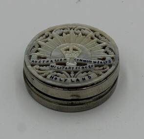
Souvenir - Souvenir ladies compact, Silver souvenir ladies compact/ utility box
Small silver souvenir ladies compact or utility boxAustralian Comm. Military Forces. "Made in Aden". Holy Land -
 Bendigo Military Museum
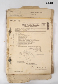
Manual - ARMOURERS COURSE NOTES, Jun 1943
Items related to the A.A.O.C. Armoured Courses for "Sgt P.L.JAMES". Refer Cat No 7446 for his service details.Loose collection of various documents and instruction that are loosely termed D.M.E. Technical instructions are of various sizes but all are bound together with two metal studs,Headed "Allied Land Forces Headquarters" - "D.M.E. Technical Instructions"armoury course, a.a.o.c. -
 Bendigo Historical Society Inc.
Document - PETER ELLIS COLLECTION: INFORMATION ON THE BARFOLD GORGE
Foolscap page of information on the Barfold Gorge, by Frank Robbins. Barfold Gorge is compared with the Sydenham Organ Pipes National Park. There is a description of the Gorge. Native vegetation growing there is also mentioned. Turning it into a National Park is mentioned but it is in private ownership and this would require buy back of the land and create access problems as it is a farming area.place, land, barfold gorge, peter ellis collection, barfold gorge, sydenham organ pipes national park, campaspe river, mitchell's falls, queen's falls, piper's creek, turpin's falls, land conservation council, victoria conservation trust, frank robbins -
 Surrey Hills Historical Society Collection
Photograph, 34 Union Road, Surrey Hills - home of the Kleinert family
This was built in 1905 and was the home of William and Emily Kleinert from 1905. William was a coach-builder, wheelwright and blacksmith. He moved from Prahran to Surrey Hills. His son Ernest worked with him as a coach painter and also worked as a painter undertaking intricate hand painting on early cars. Their other son Martin played for the Surrey Hills Football Club. In return for the support given to the club by Mrs Emily Kleinert, the club built a rotunda in South Surrey Park as a memorial to her. Alan Holt research: Lot 6 was sold to Martin Kleinert by Karl Richter in 1860 together with a portion of another adjacent lot. From 1860-1885 Martin worked it as a market garden leasing some land for grazing when it was not required for gardening. He died in 1898. In a formal document, William declared he was the son of Martin "who purchased land in 1860, died in 1898 and the land has been continually occupied by father and family since. It has been cultivated as a market garden; when not being used for gardening it was let for cultivation and grazing." William died in 1939 and the property passed to his sons Martin and Ernest. The Kleinert land extended from Union Road to Essex Road. They ran horses, ducks and fowls and Emily Kleinert grew flowers. The Kleinert property later became the South Surrey Park. The family sold the land to the Camberwell Council in the 1950s. Ernest and Ida Kleinert lived on the corner of Scotsdale and Warrigal Roads. The donor of the photo Nada Harris, nee Kleinert, was Ernest and Ida's daughter. Ida lived to a good age (> 93 years) and in later life lived in Burwood.Black and white photo of a Victorian cottage with a typical bull-nosed veranda. It is set behind a wooden picket fence with undeveloped grazing land studded with mature trees in the background. Taken front-on from the street. There appears to be a path but no formal curb to the road.south surrey park, union road, surrey hills football club, blacksmiths, wheelwrights, coachbuilders, rotunda, miss nada kleinert, mr william kleinert, mrs emily kleinert, mr martin kleinert, mr ernest kleinert, mr karl richter, mrs ida de vasy, mrs nada harris -
 Hume City Civic Collection
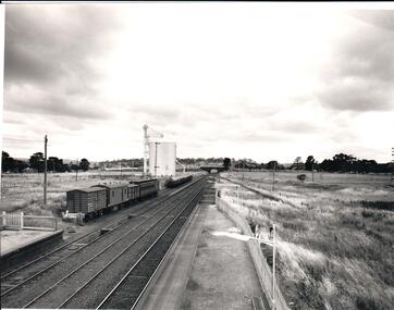
Photograph, 1/01/1971
The photograph was taken when railway land on either side of the tracks was used for recreational purposes and agricultural related activities. The local sports ground is on the RHS of the photograph and was used to stage a number of the town's events.A black and white photograph of a section of the two railway platforms and three sets of rail tracks with a stone bridge in the distance. Four rail carriages and eight goods trucks are on a railway siding near a wheat silo. There is open land on either side of the rail tracks.sunbury railway station, wheat silos, railways, macedon street rail bridge., george evans collection -
 Bendigo Historical Society Inc.
Administrative record - Application Register
The book is covered in a beige canvas to protect it. It has a leather spine with red and black labels. The pages in the volume are divided in columns: 1) Number of application, 2) Date of registry, 3) Date of application, 4) Surname, 5) Christian name and address, 6) Parish, 7) Allotment, 8) Section, 9) rea, 10) Local land board schedule, 11) Decision, 12) Special condition, 13) License, 14) References and remarks. Only two pages are used dated from 1908 are related to Swan Hill.On the spine red label with gold letters: Application register. A black label with gold letters: all other sections land act 1901. Also, on the spine in black texter 01 to 01 to - B - 145,187application register, land act 1901, 1908 -
 Whitehorse Historical Society Inc.
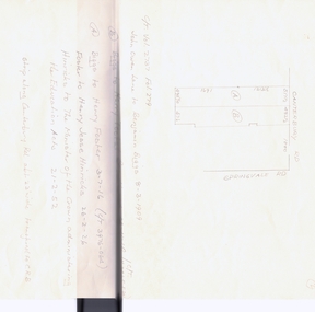
Legal record - Land Title, Forest Hill
Handwritten list of transfers of land in Forest Hill originally bought by H.R. Kefford in 1867.Handwritten list of transfers of land in Forest Hill originally bought by H.R. Kefford in 1867. Includes land of Nunawading High School and Forest Hill Shopping Centre.Handwritten list of transfers of land in Forest Hill originally bought by H.R. Kefford in 1867. springvale road, forest hill, canterbury road, kefford, h r, wakefield, john, hartnett, rhoda, reed, william, freehold investment and banking company of australia ltd., lane, john owen, mcarthur, henwood, draeger, carl julius otto, arthur herbert, loomes, vincent, biggs, benjamin, broadhurst, harry tootal, foster, henry, hinricks, henry jesse, barnes, john thomas, mary ann, jay, daniel, cuttle, thomas nathaniel, mock, walter edward, glebe street, forest hill chase, nunawading high school, land sales