Showing 10978 items matching " plan"
-
 Robin Boyd Foundation
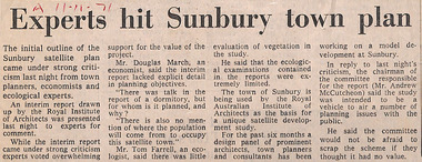
Newspaper - Clipping, The Age (possibly), Experts hit Sunbury town plan, 11.11.71
Robin Boyd conceived the idea of a satellite city in Sunbury, formulated through the Royal Australian Institute of Architects, Victorian chapter.A and date in red pen.sunbury, walsh st library -
 Robin Boyd Foundation
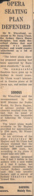
Newspaper - Clipping, Opera seating plan defended
Robin Boyd’s desk cupboard contained two exercise books (item D482.1-D482.2) and assorted articles, essays and other material regarding the building of the Sydney Opera House, inserted inside the front cover of Walkabout magazine, July 1966 (item P1377). This publication is one of those inserts. Many of these were collected by Boyd’s eldest daughter, Mandie, who recalls that her father was writing a book, but was very disillusioned with the way the entire Opera House saga unfolded.Newspaper clipping, torn edgessydney opera house, utzon, sydney opera house project, walsh st library -
 Robin Boyd Foundation
Map, Plan de Paris
walsh st library -
 Robin Boyd Foundation
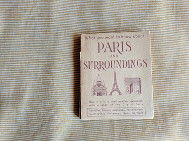
Book, Fernand Saimond, What you want to know about Paris And Surroundings : Here it is in a small practical guidebook with a plan of the City of Paris
Softcover, spine is exposed and torn, map attached at the back is ripped, stains at the back coverparis, france, travel, walsh st library -
 Robin Boyd Foundation
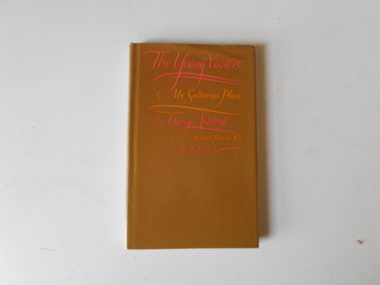
Book, Daisy Ashford, The Young Visiters or Mr Salteena's Plan, 1951
Hardcoverwalsh st library -
 University of Melbourne, Burnley Campus Archives
Document, John Patrick, Burnley Gardens Design & Management Plan 2. Educational Survey, 1980
Report by John Patrick, Dept. of Agriculture Victoria. 18 pp.john patrick, burnley gardens, design, management plan -
University of Melbourne, Burnley Campus Archives
Document, Royal Park Landscape Development Plan, 1984-1985
Draft, notes, Summary, Final Reportroyal park, landscape, development, plans -
University of Melbourne, Burnley Campus Archives
Document, Edinburgh Gardens Brunswick Street North Fitzroy Conservation Management Plan, 2003
Prepared for City of Yarra by Allom Lovell & Associates, and John Patrick Pty.Ltd.edinburgh gardens, brunswick strret, city of yarra, allom lovell and associates, john patrick pty tld, north fitzroy, conservation management plan -
University of Melbourne, Burnley Campus Archives
Document, Conservation Analysis & Management Plan for the gardens at Billila 26 Halifax Street Brighton, 1995
Work by Nan Herzberg for Graduate Diploma - Horticultural Project B, VCAH Burnley, 181 pp. nan herzberg, vcah, burnley, conservation, management plan -
University of Melbourne, Burnley Campus Archives
Document, Orchard Development Plan, 1981
Typed submission and associated correspondence. 4 items. Refer to paper catalogue.orchard -
University of Melbourne, Burnley Campus Archives
Document, Burnley Gardens Design & Management Plan, 1980
By John Patrick for Department of Agriculturejohn patrick, burnley gardens, design, management plan -
University of Melbourne, Burnley Campus Archives
Document - Report, E.M.Gibson, Report to accompany Master Garden Plan for Burnley Gardens, 1949
E.M.Gibson's reportmaster pla, burnley gardens, e.m. gibson -
Swan Hill Regional Art Gallery
Mixed media, TULLY, Ian, Shifting of Values (Farm Plan), 2000
-
Stawell Historical Society Inc
Map, Stawell Gold Mines Pty Ltd, Plan of Magdala Mine. May 1994, May 1994
Moonlight Junction, Big Newington Co. Pleasants Creek and Newington, Prince Patrick, North Cross Extended, Prince Alfred, Robson and Party, North Magdala, Galatea and Pioneer Co., Duke Magdal, Moonlight, Moonlight Extended, Sliding Shaft, Extended Cross, Crown Cross United, Great Northern, Sloanes and Scotchmans, Marinees, North Waterloo, Scothmans United, Waterloo, Scotchmans Iron Duke and Bulcher, Perthen Shire, Prince of Wales, Roberts, Shafts of Rose of Denmark, Emerald Isle Shafts, O'Donnels, Darlington,, Albion, Federal, Ulster, Goldenpoint and Wexford.AO Printed Map In Colour. Showing Underground Workings and PortalScale 1 : 2500 -
Stawell Historical Society Inc
Map, Stawell Gold Mines, Plan View of Township Area Showing Known Old Workings. 2003, 13/06/2003
Two AO Maps that Overlap Showing Old workings on Map of Town North of Patrick StreetScale 1 : 5000 -
Stawell Historical Society Inc
Map, Crowlands & Navarre Railway Construction Trust, VR Plan Showing Railway Construction District Crowlands to navarre Line 1916, 4 July 1916
Two (2) Very large Coloured Maps. Scale 40 Chains to 1 Inch. rail Line Drawn in RedShire of Kara Kara. Shire of Stawell Shire of Ararat 4 July 1916railways -
Stawell Historical Society Inc
Map, Fred W Wright Surveyor, Plan of the Borough of Stawell showing Mining leases & reefs 1870, 1870
Mining details. Including Tramways, Water Races. Crushing Mills. Reefs and Reserves.Copy of Original Showing Stawell Borough with details including mining leases Companies and MillsInsert with details of Sections 23, 34, 35 & 36. Fred W Wright 12 May 1870mining -
Stawell Historical Society Inc
Map, Plan of Division Line between Ararat and Stawell Shires 1877, 1877
Grampians Halls Gap Black Range Stawell Shire Ararat Shire Crowlands TownshipVery Large Map Printed on Linen with Table of bearingsExamined by H.C. Malcolm 28.12.77 Traced By D.H. Meike 28.12.77survey -
Stawell Historical Society Inc
Book - Report, Grampians National Park Draft Management Plan, 1985
For Public comment to National Park Service, Victoria. A Division of the department of Conservation, Forest and LandsSoft Cover with B/W Photo of aerial view of ranges of Grampians. Black taped Spine binding.$5 Barry Clugston -
Stawell Historical Society Inc
Map, Gold Mines of Australia, Stawell Investment Geological Plan. Mine Area showing Mineshafts
The Reefs Mine shaft locationsGold Mines of Australia Ltd mining, gold, map -
Stawell Historical Society Inc
Map, G C Birch Mining Surveyor, Magdala Cum Moonlight Co. Plan of Stawell Goldfield, c1900
Shows Sloanes & Scotchmans Coy AreaShowing underground drives. c1900G C Birch Mining Surveyor mining, gold, map -
Stawell Historical Society Inc
Map, Gold Mines of Australia, Plan of Stawell Goldfield. Mining Leases, 1952
And Shaft Locations 1952 G G Birch Mining Surveyormining, gold, map -
Stawell Historical Society Inc
Map, Stawell Joint Venture, Mine Site Detail Plan, September 1989
1989mining, gold, map -
Stawell Historical Society Inc
Map, H C Bates Surveyor, Plan of Underground Workings. 1888, 25/8/1888
goldMagdala Co Now Moonlight Co StawellScale 80ft to an inch H C Bates Mining Surveyor 25/8/88mining -
Stawell Historical Society Inc
Map, MPI Mines, Plan View of Township Area 2003, 13/6/2003
goldShowing known gold workings & Houses Stawell Gold Mines. 13 June 2003 1 : 7500 MPI Minesmining -
Stawell Historical Society Inc
Map, MPI Mines, Plan View of Township Area 2003, 13/6/2003
goldShowing known old gold workings Stawell Gold Mines. 13 June 2003 1 : 7500 MPI Minesmining -
Stawell Historical Society Inc
Map, Stawell Gold Mine, Plan Showing Wonga Pit and Underground Development, August 2001
Stawell Gold Mines Victoria Scale 1 : 2500mining, gold -
Koorie Heritage Trust
Book, Lo Bianco, Joseph, Victoria: Languages action plan, 1989
To our society and economy language skills overlap strongly with our multilingual population, our place in the Asian-Pacific region and our future as a trading nation in a multilingual world. We must now attend to increasing the availability and the appropriateness of the resources at our disposal..and matching these to our needs and objectives. With this action plan we have the framework to do this.98 p. : ill. ; 26 cm.To our society and economy language skills overlap strongly with our multilingual population, our place in the Asian-Pacific region and our future as a trading nation in a multilingual world. We must now attend to increasing the availability and the appropriateness of the resources at our disposal..and matching these to our needs and objectives. With this action plan we have the framework to do this.language policy -- australia. | english language -- study and teaching -- victoria. | education, bilingual -- victoria. | languages, modern -- study and teaching -- victoria. -
Koorie Heritage Trust
Book, Aboriginal Affairs Victoria in conjunction with the Kerrup Jmara Elders Aboriginal Corporation, Lake Condah Heritage Management Strategy and Plan, 1993
During its 1977/78 summer field school season, the (then) Victoria Archaeological Survey began recording and mapping the stone fish trap and 'house' sites along the southern margins of Lake Condah, near Portland Victoria. This and subsequent archaeological work at Lake Condah and in the general region demonstrates that, on the basis of a number of criteria, the Aboriginal heritage sites found here are significant.vii, 388 p., [11]. leaves. : ill., foldout maps. ; 30 cm.During its 1977/78 summer field school season, the (then) Victoria Archaeological Survey began recording and mapping the stone fish trap and 'house' sites along the southern margins of Lake Condah, near Portland Victoria. This and subsequent archaeological work at Lake Condah and in the general region demonstrates that, on the basis of a number of criteria, the Aboriginal heritage sites found here are significant.conservation of natural resources -- victoria -- condah, lake, region. | aboriginal australians -- victoria -- condah, lake, region -- antiquities. -
Malmsbury Historical Society
Photograph (Item), Malmsbury Church Floor Plan, Malmsbury
Buildings - Malmsbury Church