Showing 9729 items
matching reserve
-
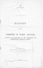 Melbourne Tram Museum
Document - Report, Parliament of Victoria, Report from the Committee of Public Accounts MMTB, Nov. 1927
Report - 10 pages - "Report from the Committee of Public Accounts (Accounts and Activities of the Melbourne and Metropolitan Tramways Board)", dated 24-11-1927. Looks at the accounts, causes of past deficits, financial position of the Board, statutory obligations, reserve funds, employee's benefits, use of buses, burdens borne, operating costs, use of buses, roads, cable tram conversions and has recommendations. Note: This document is available as a pdf on the Parliament of Victoria website.trams, tramways, tramways, cable trams, finances, conversion, buses, costs -
 Ringwood and District Historical Society
Map, Plan of the Parish of Warrandyte County of Evelyn - 1841
Blueprint copy of Survey Map W27 detailing original Selectors' names and property locations between Yarra Yarra River (Warrandyte) and Mullum Mullum Creek (Ringwood). List of Parish map references including property bearings, distances in Links, and markings on trees. Pound Bend area of Warrandyte marked as Reserve For Aborigines. Descriptive remarks include areas marked "scrubby, flat, sandy soil". Several other references faded and illegible.(Map) by T.H. Nutt Feb 3 1841. -
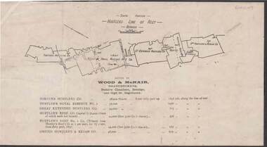 Bendigo Historical Society Inc.
Document - KELLY AND ALLSOP COLLECTION: HUSTLERS LINE OF REEF MAP, 30/07/1891
Document. KELLY & ALLSOP COLLECTION. Map of the Hustlers Line of Reef, Bendigo (South portion). Issued by Wood & McNair, Sharebrokers, Beehive Chambers, Bendigo and High St., Eaglehawk. Mines shown on map are Fortuna Hustler's Co., Hustler's Royal Reserve No.2, Great Extended Hustlers Co., Hustlers Reef Co., Hustler's Reef No.1 Co., United Hustler's & Redan Co. Number of shares is listed against each of these mines.Wood & McNairbusiness, stockbroker, kelly & allsop, kelly & allsop collection, hustlers line of reef map, wood & mcnair. -
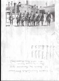 Bendigo Historical Society Inc.
Photograph - PHOTOCOPY OF A BLACK AND WHITE PHOTO OF THE CAMPBELLS FORREST CATHOLIC PARISH CONTINGENT
Photocopy of a black and white photo of The Campbells Forrest Catholic Parish contingent - St Patrick's Day Procession 1937 taken in the upper reserve (later called Queen Elizabeth Oval). Six men and a woman mounted on horses with some buildings behind them,they appear to be wearing top hats and a bowler hat . The names are given as Jo Ketterer, Victor Warde, Norma Farnele , Jack Keating, Jim Duggan, Jack Duggan, Vince Warde.photograph, person, the campbells forrest catholic parish contingent / st patrick's day procession 1937 / jo ketterer , victor warde , norma farnele , jack keating , jim duggan , jack duggan , vince warde -
 Bendigo Historical Society Inc.
Document - UNDERGROUND SURVEY OF BENDIGO MINES
Two page document, 'Underground survey of Bendigo, report on Constellation Company's Mine on northern extension of the Garden Gully line of reef. Report on the New Chum Railway Reserve Company and the Shenandoah Company, the New Chum Railway Co being immediately south and the Shenandoah Co immediately north of the railway line. Two maps Constellation Co. Mine shaft and New Chum Railway and Shenandoah auriferous reef below 2700 feet.Jems Stirling, geologist and W.H Cundy Underground Surveyor, Department of Minesbendigo, mining, garden gully line of reef mines -
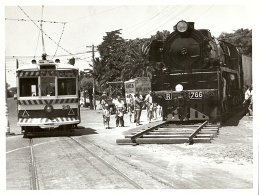 Bendigo Historical Society Inc.
Photograph - BASIL MILLER COLLECTION: TRAIN AND TRAM IN MITCHELL STREET, BENDIGO, early 70's
Black and white photograph of No 29 tram on Mitchell Street. On RH side of photo Train R 766 being shunted on improvised lines onto VRI reserve on Railway Place. Between tram and train, people observing movement of train. Trailer 'RW James, for hire' in view to rear of train. Stamped on back: 'copyright, The Bendigo Advertiser Newspapers'. Pencil written '4 1/2 x 5' 66% page 79' on back.Bendigo Advertiserperson, individual, basil miller -
Bendigo Historical Society Inc.
Document - VICTORIA HILL - RECOMMENDATION - MINING PROJECT
Two (a & b) typed copy of a recommendation for mining project, accepted Nov. 1967. Recommendation for Central Nell Gwynne area, now a public purposes reserve for preservation as a permanent reminder of the gold mining era. Victoria Hill Area mentioned for it's geographical and historical significance. The New Chum Hill area rich in historical and mining. Notes on development of the Central Nell Gwynne, Victoria Hill and New or Old Chum Hill areas.mine, gold, victoria hill, victoria hill, recommendation - mining project, central nell gwynne, jack barker, victoria hill area, big 180, victoria quartz, new chum hill (old chum hill), p. m. g. repeater station, mine's department, land's department, lansell, fortuna, a h q survey regiment, lazarus mine, b c v 8 television studio -
Bendigo Historical Society Inc.
Document - MCCOLL, RANKIN AND STANISTREET COLLECTION: SCRAPBOOK - WORLD WAR I, 1915
McColl Rankin & Stanistreet. Scrapbook WWI. Exercise book with newspaper cuttings about Australians in WWI. Australia Day, Bendigo Recruits Return, At Upper Reserve, The Receipts, Departure of Troops, Gallipoli, Returned Soldiers, A Woman in War, Bendigo Training Camp, Anzac Day, Bendigo Battalion, Pioneer Cabwoman on the Rank in Bendigo (Mrs Charlotte Jackson). Pictures from papers in articles. On display at library 21.2.19, in 'These are a few of my favorite things'organization, business, wwi, wwi australia day bendigo recruits return upper reserve the receipts departure of troops gallipoli returned soldiers woman in war bendigo training camp anzac day bendigo battalion pioneer cabwoman on the rank in bendigo -
 Greensborough Historical Society
Map, Melbourne and Metropolitan Board of Works. Survey Division, MMBW, Yarra 2500 / 12.23. Janefield and Kangaroo Point, 1977_10
Melbourne and Metropolitan Board of Works. Yarra 2500 [base map] 12-23, Municipalities of Whittlesea 239 and Diamond Valley 257. No streets marked on this map. Includes Plenty River, Kangaroo Point, Janefield Colony and Janefield Reserve.MMBW Map in 1:2500 [scale] series. Cream parchment with green tape reinforcing on edges and punched holes on left edge.mmbw, melbourne and metropolitan board of works, shire of diamond valley, plenty - maps -
Tatura Irrigation & Wartime Camps Museum
Photograph - original, N. R. McGeehan photographer, Cross Silver Wedding 1933, 1933 original
Original photograph of group of people celebrating the Cross silver wedding. 5 August 1933. Jack Welpdale (bottom right hand corner), Bertha (wife) next in coat with fur on collar and cuffs. Former residents of "Reserve" Tatura.Black and white photograph of the Cross silver wedding 1933.on back: Jack and Bertha Whelpdale, identified. -
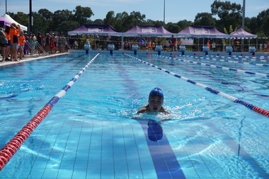 Galen Catholic College
Galen Catholic College Swimming Carnival, 2022
Galen Catholic College has a swimming carnival every year. This series of photographs captures the unbridled enthusiasm of the competitors and supporters alike. This swimming carnival was one of the first held at the new outside Olympic pool at the Barr Reserve in Wangaratta. galen catholic college, galen college, swimming, swimming carnival, 2022 -
Glen Eira Historical Society
Postcard - GLEN HUNTLY
This file contains 1 item about Glen Huntly: 1/1 colour postcard (150mm x 96mm) attributed to Margie McKenzie Photography, undated. It depicts Garden Avenue Reserve, Glen Huntly (Mel Ref 68F6)parks and reserves, glen huntly, garden avenue, garden avenue park, gardens -
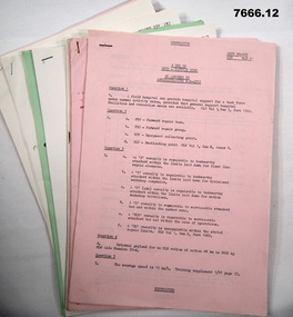 Bendigo Military Museum
Document - TRAINING NOTES - ARMY, 3rd Training Group
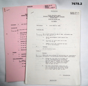
Notes relate to courses run by 3rd Training Group - Reserve Command and Staff college between May 1981 and May 1988. Part of the "Kevin John Herdman" No 397661 collection. See catalogue No. 5942P for his service details.1. - 12. A4 sized multi page documents, each stapled on top LHC. Text on each page in black type. Printing on one side of each page. Pages vary in colour - pink, cream, blue and green.Handwritten markings on various pages in red and black ink.training notes, army, 3rd training group, kevin john herdman -
 The Beechworth Burke Museum
Photograph - Postcard, c1900
The construction on Lake Kerferd began in 1862 however it wasn't completed until 1874 due to engineering and funding issues. The lake was named after George Briscoe Kerferd (1831–1889) who was responsible for Beechworth's water scheme. George Briscoe Kerferd was born on 21 January 1831 in Liverpool, England and arrived in Melbourne April 1853. He spent his first years in Australia in Bendigo before settling down in Beechworth as a wine and spirits merchant. He married Ann Martindale on 17th December 1853 at St James Cathedral, Melbourne and between them they had three sons and five daughters. Kerferd began his political and legal career in Beechworth when he was first elected to the Municipal Council in May 1857. Later he would be elected to the Legislative Assembly for the Ovens District in November 1864, and continued to represent the area until February 1886. This photograph is historically significant as it provides insight into the water reserves of Victoria. It also demonstrates the political identity of George Briscoe Kerferd and the Beechworth Municipal Council.Sepia rectangular postcard printed on paperObverse: Reverse: 83-131-1/ Post Card/ Correspondence / Address Only / BMM2997 / 53 / [Kodak Australia Stamp] lake kerferd, beechworth, water scheme, water reserve, reservoir, legislative assembly, hon. george briscoe kerferd, catchments, beechworth water reserve, beechworth catchments, municipal council, st. james cathedral, lakes, reserve, water supply, political projects -
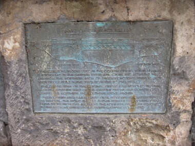 Greensborough Historical Society
Photograph - Digital image, Dennis Ward, Bridge Plaque - Pioneer Park Greensborough, 27/03/2010
Plaque at Pioneer Reserve Greensborough: "Shire of Diamond Valley. The bluestones used in the construction of this viewing platform and in the carpark entry structure and retaining wall are from the northern arch of Greensborough's first Plenty River Bridge built in the 1860s adjacent to this site. The centre span of the original bridge was removed in 1865 when the western half of the existing bridge was constructed leaving the northern and southern stone arches. The southern arch was retained until floods in 1874 necessitated its removal. The picnic shelter in this reserve was constructed using stone from this abutment. The northern arch was removed in 1983 when widening of the existing bridge commenced."Digital copy of colour photograph.plenty river, pioneer reserve greensborough -
 Bendigo Military Museum
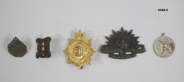
Badge - BADGES VARIOUS, 1) Wallace Bishop, 1) 1940, .2) pre 1939, .4) 1939 - 45, .5) 1945
.1) Badge metal 6 sided crown at top, centre has Coat of Arms, one lug on the rear and numbered. .2) Badge pressed brass squarish shape scroll at top and bottom, centre has a figure "8", two lugs on rear. .3) Badge pressed metal gold colour crown at top, centre has letters "ER" surrounded by circles and a wreath, two lugs on rear. .4) Badge pressed metal blackened with Rising Sun depiction crown at top. .5) Badge round silver colour, one side is map of Australia with person over, rear has map depiction of the world..1) On front, "Reserve Occupation", on rear, "A17936", "Issued by the Commonwealth Govt". .2) On front, "8th Aust Inf Regt, cede Nullis". .3) On front, "Royal Australian Army Service Corp". .4) "Australian Commonwealth Military Forces". .5) On one side, "1945", on other, "Victory Medal".badges, uniform, headwear -
 Dandenong/Cranbourne RSL Sub Branch
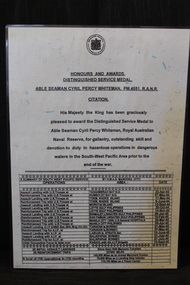
Document - Citation to PM4551 Able Seaman Cyril Percy Whiteman R.A.N.R, Citation to ABLE SEAMAN CYRIL PERCY WHITEMAN, PM445,R .A. N.R, unknown
WWII historical significanceCitation His Majesty the King has been Graciously pleased to award the Distinguished Service Medal to Able Seaman Cyril Percy Whiteman. the Royal Australian Naval Reserve, for gallantry, outstanding skill and devotion to duty in hazardous operations in dangerous waters in the South-Wes Pacific Area prior to the end of the war. -
 Greensborough Historical Society
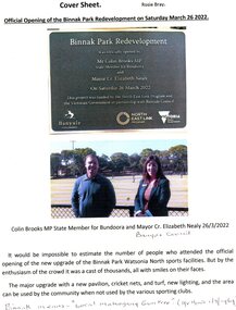
Article - Article and Leaflet, Rosie Bray et al, Official opening of the Binnak Park redevelopment on Saturday March 26 2022, July 2020 , November 2021 and March 2022
An upgrade at Binnak Park Watsonia will improve facilities for the Plenty Valley Cricket Club and Watsonia Sporting Club , which have been displaced from A K Lines Reserve by construction of the North East Link, Binnak Park to continue their activities5 p. comprising 4p. North East Link "Binnak Park Community Update" 2020, with Cover sheet by Rosie Bray and colour photograph of the park at openingbinnak park, banyule parks, binnak park watsonia, north east link -
Greensborough Historical Society
Newsletter, Greenhills and North Greensborough Progress Association, Community News: official journal of the Greenhills and North Greensborough Progress Association. 25th October, 1971. Edition No. 8/71, 25/10/1971
This edition includes report on the Progress Association October 1971 meeting, Councillors' reports, "Greenmeyer", The ten commandments of conservation, The all-purpose melaleuca, Letter to the Editor, School and Kinder news, Australia's heritage, Fishermen and Yandell Reserve, Personal news.Newsletter, 18 p., illus. greenhills and north greensborough progress association, greenhills -
 Bendigo Military Museum
Document - TRAINING NOTES, ARMY
1. 'Exercise Micro Log'. Third Training Group, Reserve Command and Staff College, MILOPS Wing. 2. Exercise 'Mini Log.' Part of the Kevin John Herdman, No.397661 collection. See Catalogue No.5942P for details of his service.1. Multipage document on A4 sized paper. Text on one side of each page in black. Pages are cream in colour and stapled together on top LHC. 2. Multipage document on pink coloured A4 paper, Text on one side of each page in black. Pages stapled together on top LHC.2. Handwritten on top RHC of first page; MASTER 81, Sec attached sheets.training notes, exercise microlog, exercise mini log, kevin john herdman -
Port Melbourne Historical & Preservation Society
Badge (Item) - Imperial League of Australia Badge, c.1950
The Imperial League of Australia badge returned service badge belonged to Robert Cornelius WATTERS, a member of the Royal Australian Naval Reserve. He served as a Leading Sick Berth Attendant from 11 September 1940 - 21 March 1944.Returned Soldiers Sailors Airmen, Imperial League Australia. 66robert cornelius watters, armed services - navy, royal australian naval reserve, imperial league of australia -
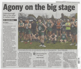 Greensborough Historical Society
Newspaper Clipping, Diamond valley Leader, Agony on the big stage, 25/09/2019
Greensborough fails to fire when it matters most. The seniors and reserves sides had lost just one game between them before Saturday, with both enduring stunning upset defeats in their respective NFL Division 1 grand finals.News article 1 page, black text.northern football league, greensborough football club, west preston-lakeside football club -
 Eltham District Historical Society Inc
Photograph, Liz Pidgeon, Heritage Excursion; East of Eltham, 6 Sep 2014, 20 May 2017
Newsletter No. 218, September 2014 September Excursion - East of Eltham Walk In Newsletter No. 197, March 2011, there was a brief history of Crown Allotment 15 Section 5 Parish of Nillumbik (CA 15) a parcel of land of a quarter of a square mile extending from Eucalyptus Road to Reynolds Road at the eastern extremity of Eltham. From the 1940s it was known as Stokes orchard. In later years it has been subdivided for residential purposes but leaving significant areas as power line and water supply reserves and bushland reserves that are habitat for the threatened For our excursion on 6th September we intend to walk through CA 15 to a bushland reserve east of Reynolds Road. The walk will traverse the boundary between suburban Eltham and the non-urban areas to the south and east. This is a pleasant walk through residential areas and bushland. Along the way we will discuss the early and more recent history of CA 15 as well as local natural history and geology. This walk is about 3.5 km in length and will take 2 to 2.5 hours. It will start at 2pm at the corner of Eucalyptus Road, Pitt Street and Nyora Road.Born Digitaleltham east, eltham district historical society, heritage excursion, activities, nyora road, reynolds road, gum tree road reserve, diosma road, stokes orchard, eucalyptus road -
 Eltham District Historical Society Inc
Photograph, Liz Pidgeon, Heritage Excursion; East of Eltham, 6 Sep 2014, 20 May 2017
Newsletter No. 218, September 2014 September Excursion - East of Eltham Walk In Newsletter No. 197, March 2011, there was a brief history of Crown Allotment 15 Section 5 Parish of Nillumbik (CA 15) a parcel of land of a quarter of a square mile extending from Eucalyptus Road to Reynolds Road at the eastern extremity of Eltham. From the 1940s it was known as Stokes orchard. In later years it has been subdivided for residential purposes but leaving significant areas as power line and water supply reserves and bushland reserves that are habitat for the threatened For our excursion on 6th September we intend to walk through CA 15 to a bushland reserve east of Reynolds Road. The walk will traverse the boundary between suburban Eltham and the non-urban areas to the south and east. This is a pleasant walk through residential areas and bushland. Along the way we will discuss the early and more recent history of CA 15 as well as local natural history and geology. This walk is about 3.5 km in length and will take 2 to 2.5 hours. It will start at 2pm at the corner of Eucalyptus Road, Pitt Street and Nyora Road.Born Digitaleltham east, eltham district historical society, heritage excursion, activities, nyora road, reynolds road, gum tree road reserve, diosma road, stokes orchard, eucalyptus road