Showing 113077 items
matching road
-
 Eltham District Historical Society Inc
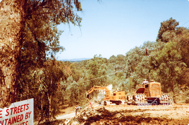
Photograph, Road construction near Progress Road, Ryans Road, Eltham North, 1983, 1983
Originally contained in a 'magnetic' photo album believed to have been donated by Mr Eric Stephenson, Jingalong, 110 Ryans Road, Eltham, Vic. 3095; relocated to archival safe storage.Four colour photographseltham north, road construction, ryans road, progress road -
 Kew Historical Society Inc
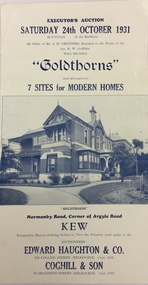
Document, Executor's Auction, Sunday 24th October 1931, "Goldthorns", Normanby Road, Corner of Argyle Road, Kew, 1931
Rare real estate brochure relating to the sale of a historically significant Kew mansion. The rarity the document is increased due to the photographs of the front of the house and of the extensive rear garden.Four page flyer advertising the sale of Goldthorns in Normanby Road, Kew in October 1931. The flyer contains a photograph of the front of the house, a list of its rooms, a site plan (including possible subdivisions). and a photo of the rear garden.goldthorns - normanby road, kew (vic), real estate - kew (vic), griffith family - kew (vic), gardens - kew (vic), subdivisions - kew (vic) -
 The Beechworth Burke Museum Research Collection
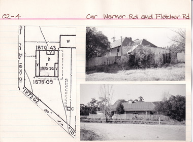
Card (Series) - Index Card, George Tibbits, Cnr Warner Road and Fletcher Road, Beechworth, 1976
George Tibbits, University of Melbourne. Faculty of Architecture, Building and Town & Regional PlanningIndex system that support the research for Beechworth : historical reconstruction / [by] George Tibbits ... [et al]Arranged by street names of BeechworthEach index card includes: street name and number of property, image of property, allotment and section number, property owners and dates of ownership, description of the property according to rate records, property floor plan with dimensions.beechworth, george tibbitsbeechworth, george tibbits -
 Ringwood and District Historical Society
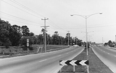
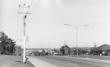
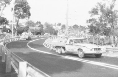
Photograph, Maroondah Highway East, Ringwood- 1969. Looking west towards Ringwood from Mt Dandenong Road intersection
Black and white photographWritten on back of photograph: "Nov 1969, Cnr Mt Dandenong Road and Maroondah Highway." -
 Ringwood and District Historical Society
Photograph, Maroondah Highway East, Ringwood- 1969. Looking west towards Ringwood from Mt Dandenong Road
Black and white photographWritten on back of photograph: "Cnr Maroondah Highway and Mt Dandenong Road. Nov 1969." -
 Kiewa Valley Historical Society
Postcard Circa 1950, Road to Bogong High Plains Kiewa Hydro Electric Project, Circa 1950's
This postcard was produced in the 1950's for the tourist trade in the Kiewa Valley and Alpine region. It encompasses the period when the State of Victoria was pressured by the ever increasing demand by industry and its population for electricity supplies. Hydro electricity was seen as an untapped natural resource to quench this demand. The Victorian Alps and the rivers flowing into its valleys was ideal for the construction of the Kiewa Hydro Electricity Scheme. The late 1940's saw the development of this scheme and the changing of sections of alpine landscape is covered by this and other postcards/pictures (tourists, construction workers, and established rural populations). This period in time was before the established wildlife and forest/nature groups became political activist who changed legislative acts to protect the environment.This rural region (Kiewa Valley/alpine plains) was at most only significant to a smaller group of winter sports, summer hikers/horse riders and rural farmers/graziers. The numbers of tourists and the increase in the local resident population was boosted by the construction of the Hydro Electricity Scheme. This influx to the regional population resulted in a corresponding diversity in services and brought about an environment that responded to a growing level of tourists and thereby permitting this industry to grow more rapidly than it would have naturally. This postcard details an attraction to the "cleaner" method of providing electricity. This postcard was purchased in 1950 by a surveyor at Landford's Gap.This black and white photograph on a Valentine's postcard is from a V2 Argus photograph.. It is on a 200g/m paper density photo side gloss. See 0480 (A) - (G) for other photos of similar postcards.In white lettering " ROAD TO BOGONG HIGH PLAINS KIEWA HYDRO-ELECTRIC PROJECT", V3secv, road making, victorian alps -
 Emerald Museum & Nobelius Heritage Park
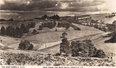
Photograph/postcard, Rose Series Postcards 'View from the Main Road, Emerald, Vic, circa 1930's - 40's
Early panorama of EmeraldPostcard from the Rose SeriesFront: The Rose Series P. 2774 'View from the Main Road, Emerald, Vicrose postcard series, emerald -
 Ringwood and District Historical Society
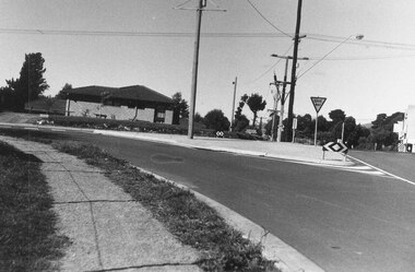
Photograph, The left turn lane from Oban Rd. into Warrandyte Road, North Ringwood 1981
Written on back of photograph, "The left turn lane from Oban Rd. into Warrandyte Road". -
 Ringwood and District Historical Society
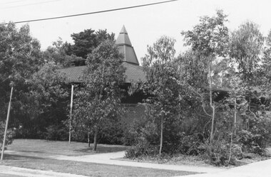
Photograph, Seventh Day Adventist Church, Mullum Road, Ringwood 1982
Catalogue card reads, "Ringwood, 1982. Seventh Day Adventist Church, Mullum Road." -
 Ringwood and District Historical Society
Photograph, The surfaced bypass for Mullum Mullum Creek, Warrandyte Road, Ringwood. Possibly 1987
Written on back of photograph, "Date ? The surfaced bypass for Mullum Mullum Creek, Warrandyte Road." -
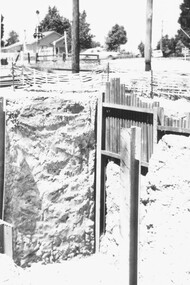
 Ringwood and District Historical Society
Photographs, 1979-80 MMBW pipe line project at Hubbard Reserve, North Ringwood � MMBW compound in Evelyn Road
Part of a 43-photo record of the MMBW�s engineering feat in drilling a 12 inch pipe line up to 40 feet deep through rock hardened by volcanic action associated with geological fault that occurs along the line. The work took place from October 1979 to May 1980 on the southern boundary of Hubbard Reserve, North Ringwood. The collection was presented to the Ringwood Historical Research Group by J Clarke on 9th June 1980.E563 N2 12 April 1980 A43 MMBW compound in Evelyn Road gully -
 Ringwood and District Historical Society
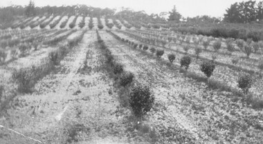
Photograph, H. E. Watson's Orchard. Ringwood East. Oxford Road (undated)
Black and white photographWritten on back of photograph- "H. E. Watson's Orchard. Ringwood East. Oxford Road."agriculture -
 Ringwood and District Historical Society
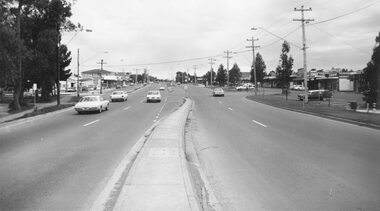
Photograph, Canterbury Road, Heathmont looking east from railway bridge. 1973
Catalogue card reads, "Canterbury Road, Heathmont looking east from railway bridge." -
 Ringwood and District Historical Society
Photograph - Collection, Warrandyte Road, Ringwood bridge opening, Tom Roper (MP) and Ringwood Mayor Cr. Lillian Rosewarne, May 1987 ( 9 photographs)
Catalogue card reads, 'Warrandyte Road bridge opening, Tom Roper, May 1987'. -
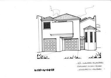 Hawthorn Historical Society
Drawing - Property Illustration, 2/5 Illawarra Road, Hawthorn
'After training as a Cartographic Draftsman within the mining industry, I worked as a property illustrator for real estate firms in the eastern suburbs of Melbourne for 23 years from 1983. I initially photographed houses with a Polaroid camera and made a 'thumbnail' sketch while there. The photos were used to scale off a sketch in pencil and then that sketch was overlaid with drafting film and the 'pen and ink' completed. The pens I used were the Rotring ‘Rapidigraph’ drafting pens. The ink was also made by Rotring (German).The film was ‘Rapidraw’, polyester drafting film, double matte. It takes a very fine line and doesn’t bleed. As well as house sketches, there were often floor plans and site plans ordered. Aerial sketches were ordered when the property needed an overall view.' (Margaret Picken, 2020)This property illustration is one of a series created by Margaret Picken for a range of real estate agents in Melbourne between c. 1983 and c. 2006. Each work is signed and dated by the artist.Gift of Margaret Picken, 2020pen and ink architectural drawing on drafting film.2/5 ILLAWARRA ROAD, HAWTHORN Margaret Picken ©2000 WOODARDS - HAWTHORNartist - margaret picken 1950- -
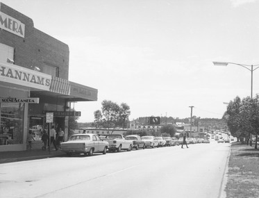 Ringwood and District Historical Society
Photograph, Maroondah Highway Central, Ringwood. Looking east towards Warrandyte Road, 1974
Black and white photographNil Image shows Hannams Camera store, and Safeway roof near Warrandyte Road. -
 Ringwood and District Historical Society
Photograph, Schwerkolt Cottage, Deep Creek Road, Mitcham - 1964
Black and white photograph- 2 images of front and back entrances of cottage. (2 copies of each image)Written on rear of backing sheet: "Schwerkolt Cottage, Deep Creek Road, Mitcham, 1964." -
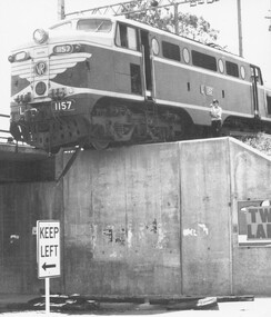 Ringwood and District Historical Society
Photograph, Diesel engine No. 1157 involved in derailment at Wantirna Road, Ringwood on Wednesday 29 January 1969
Black and white photograph, newpaper clippings and railway magazine extract.Diesel engine No. 1157 involved in derailment at Wantirna Road Bridge., on 29-01-1969 -
 Ringwood and District Historical Society
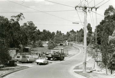
Photograph, Construction work Bedford Road railway crossing, Ringwood. 1977 - 11/77
Black and White PhotographRear of photo shows, "Construction work Bedford Road railway crossing. 11/77 -
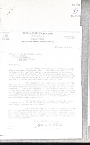 Whitehorse Historical Society Inc.
Letter - Correspondence, Land Acquisition - Mason Road, 21/04/1938
Letters between Real Estate Agent (T.R.B. Morton & Son) and Solicitor (W.B. & O.M. McCutcheon) concerning acquisition of land by the local municipal council from Mrs M.L. Wheeler at the corner of Mason Road and Blackburn Road, Blackburnland sales, wheeler, m. l. (mrs), blackburn road, blackburn, masons road -
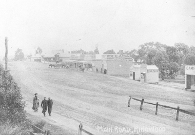 Ringwood and District Historical Society
Photograph, Maroondah Highway Central, Ringwood. Looking west from Warrandyte Road, 1910
Black and white photograph (2 copies)Written on rear of backing sheet of one photograph: "Main Road, Ringwood, looking west, Warrandyte Road coming in from right.". Image of central Ringwood including the E.S.& A. bank, Ringwood's first bank, 1910. -
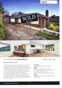 Greensborough Historical Society
Advertising Leaflet, Buckingham and Company Estate Agents, 2A Rattray Road Montmorency; and, 16 Looker Road Montmorency, 2018_08
Advertising for 2A Rattray Road Montmorency, 3 bedroom house, sold October 2018 for $670,000; and, 16 Looker Road Montmorency 3 bedroom house, sold October 2018 for $840,000; previous sales: February 1999 $145,000 and July 1998 $203,000. Colour page from real estate magazine, printed both sides.rattray road montmorency, looker road montmorency -
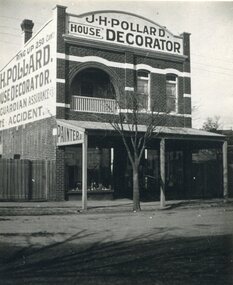 Surrey Hills Historical Society Collection
Photograph, Shop of J H Pollard, House Decorator, at 139 Union Road, Surrey Hills, 1930
This site was later occupied by Mitton's pharmacy. James Henry Pollard appears on the 1903 electoral roll as a painter in Canterbury Road (in one of the buildings that made up Hansen's Terrace.)The Union Road shops are covered by a City of Boroondara Heritage Overlay. This particular shop has changed very little with some alteration to the upper storey when it was repurposed for residential dwelling.Black and white photo of James Henry Pollard's shop at 139 Union Road, Surrey Hills in 1930. It is a 2 storey brick building with 2 glass display windows either side of the door and a corrugated iron roofed verandah supported on 3 posts. Above is a dwelling with 2 sash windows and an interior balcony within an arch. A wooden paling fence adjoins on the left. The side of the building and the front pediment carry advertising for the business. From this it appears that James Henry Pollard was an insurance agent for Guardian Assurance Company as well as being a house painter and decorator. There is a deciduous tree in the front of the shop.businesses, shops, mitton's pharmacy, guardian assurance company, union road shops, james henry pollard, painter, decorator -
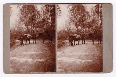 Marysville & District Historical Society
Photograph (Item) - Black and white bi-focal image, Unknown
An early black and white bi-focal image of men and packhorses on the Marysville-Wood's Point Road in Marysville in Victoria.An early black and white bi-focal image of men and packhorses on the Marysville-Wood's Point Road in Marysville in Victoria. This is now known as the Marysville-Wood's Point Road. The Marysville-Woods Point Road was originally part of the Yarra Track, constructed in the early 1860s to provide access between Healesville and the Woods Point Goldfields. Despite the steep terrain and engineering difficulties, the Yarra Track soon became a busy route used by pack horses, horse-drawn drays, and wagons. Today this sealed mountain road is a popular scenic drive between Marysville and Warburton.Packhorses on Wood'spoint Road/ Marysville/ Victoriapackhorses, wood's point road, marysville-wood's point road, marysville, victoria, yarra track, healesville, wood's point goldfields, warburton -
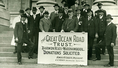 Lorne Historical Society
Photograph, Great Ocean Road Trust, taken at Geelong Town Hall 1918
Group photography Great Ocean Road Trust, taken at Geelong Town Hall 1918great ocean road. geelong town hall -
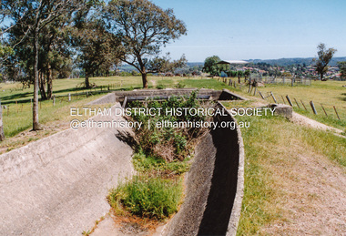 Eltham District Historical Society Inc
Photograph, Maroondah Aqueduct north of Allendale Road, Eltham North
Four colour photographs of abandoned Maroondah Aqueduct north of Allendale Road, Eltham Northaqueducts, maroondah aqueduct, allendale road, eltham north -
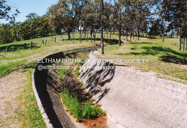 Eltham District Historical Society Inc
Photograph, Maroondah Aqueduct north of Allendale Road, Eltham North
Four colour photographs of abandoned Maroondah Aqueduct north of Allendale Road, Eltham Northaqueducts, maroondah aqueduct, allendale road, eltham north -
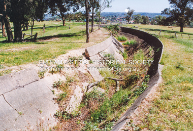 Eltham District Historical Society Inc
Photograph, Maroondah Aqueduct north of Allendale Road, Eltham North
Four colour photographs of abandoned Maroondah Aqueduct north of Allendale Road, Eltham Northaqueducts, maroondah aqueduct, allendale road, eltham north -
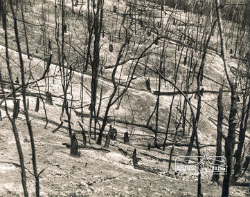 Eltham District Historical Society Inc
Photograph, George W. Bell, Laughing Waters Road Area, Mar 1965, 1965
Black and white photograph of bushfire aftermath, Laughing Waters Road area, Eltham 1965.laughing waters road, eltham, fires, bush fires, george w bell collection -
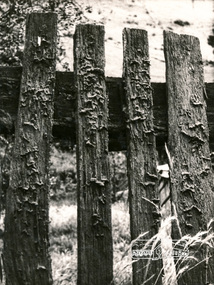 Eltham District Historical Society Inc
Photograph, George W. Bell, Fence, farmhouse, Yarra Glen Road
Black and white photograph of timber picket fence Yarra Glen Road Kangaroo Groundyarra glen road, kangaroo ground, fences, george w bell collection